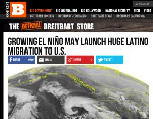
Last year, a website called “Breitbart” ran a piece about the growing El Niño in the equatorial Pacific, a climate pattern that shifts weather across much of the Earth.
Without evidence – let us be clear, the author of the piece offers a chain of cobbled together logical fallacies but zero evidence – Breitbart’s Chriss Street warns ominously that El Niño means “millions of impoverished peasants may soon be headed for the United States” – an evidence-free stretch to turn a normal piece of science journalism into racist clickbait, fueling and fueled by fear of a brown hoard of “other” poised on our southern border. It was true-to-form Breitbart – “a site known for its nationalist, racially charged, conspiracy-laden coverage“. Breitbark is a masterwork in hateful, but remarkably, frighteningly successful, propaganda.
The former proprietor of that site, Steve Bannon, was just named “chief strategist and senior counselor” to president-elect Donald Trump.
Evidence shows that more than 3 billion years ago Mars was wet and habitable. However, this latest research reaffirms just how dry the environment is today. For life to exist in the areas we investigated, it would need to find pockets far beneath the surface, located away from the dryness and radiation present on the ground.
So, not a lot of good reservoir sites, really no choice other than (unsustainable?) groundwater pumping.
Laura Paskus has a new piece touching on an issue that is one of the most important policy problems in western US water management – the tendency of water managers to overestimate future demand. In this case, it’s the Gila River basin in southwestern New Mexico, where planners are considering significant investment to build a new water diversion for use by the region’s communities. But will that water be needed in the long run? She’s quoting here Craig Roepke, prior to his retirement as the state of New Mexico’s manager for the Gila project:
But before the engineers laid out planning options for the board to consider, Craig Roepke, the New Mexico Interstate Stream Commission’s Gila Region Manager, set the stage. His remarks focused on the demand for additional water in the region. On a screen at the front of the room, he showed that water demand ranged from 45,000-160,000 acre feet of water (slide nine in this PowerPoint presentation).
Roepke called it a “rough cut” estimate of water needs in southwestern New Mexico.
“It doesn’t matter where you put a project or what it would be,” he told the board members. “Even if you could develop every acre of AWSA water, you couldn’t ever meet needs, even in any particular basin.”
That’s a lot of water needed. But when Laura dove into the details, the ISC could come up with no data to support those numbers, and, as she explains, there is some doubt that that much water will ever be needed.
As I wrote last summer in a piece for the Breakthrough Journal, we have a long history of overestimating future water demand and therefore overbuilding water infrastructure in response. This is a problem.
My University of New Mexico Water Resources Program colleague Bruce Thomson loves to point out that Albuquerque’s wastewater treatment plant is, in New Mexico, the second largest tributary to the Rio Grande after the Rio Chama. But as tributaries go, it’s a short one – under 100 yards/meters from the outfall to the main river channel. I’ve long harbored a not-so-secret dream/scheme – what if, rather than a short rock-lined channel, we could route that water through the nearby riverside woods, getting an increased benefit in riparian vegetation and habitat along the way?
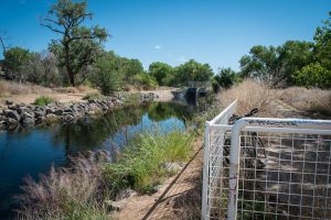
The long-dead Santa Cruz River could flow again within two years.
Tucson Water, which had opposed the idea for years, unveiled a blueprint last week for putting heavily treated wastewater in the river through downtown Tucson. Officials call the plan “Agua Dulce,” Spanish for sweet water.
The idea would be to pump the effluent uphill from a sewage treatment plant northwest of the city via an existing pipeline south to 29th Street. From there, effluent would run downhill through the city’s core; the Santa Cruz flows south to north. Officials don’t know yet know how far downstream the water would run.
There are big differences, but the underlying principle is similar – leverage wastewater for environmental benefit. Lots of hurdles in both cases. In Albuquerque, the most important one would be the water losses – the riparian vegetation my scheme would consume water.
If the deal goes through – and there are hurdles yet to clear – Arizona, California, and Nevada would all agree to further cuts in their use of Colorado River water. It would be the third major agreement among the states and the federal government in the last two decades, deals that have repeatedly sidestepped the risk of litigation over unsettled legal questions about who is entitled to how much of the river’s increasingly scarce water.
Under the deal Nevada and Arizona would take deeper cuts than those already locked in by a 2007 multi-state agreement. In addition, California (which has senior water rights and therefore the strongest bargaining position) would also agree to join in the reductions. Arizona, which pumps Colorado River water uphill from Lake Havasu to the farms and cities of the Phoenix-Tucson region, would take by far the biggest cuts. But having California join in the reductions is a huge breakthrough in finding a workable solution to the Colorado River’s problems.
The deal’s been talked about for some time, so much of what’s in the MWD staffpresentations is not new. But Monday’s public meeting begins the next step in the process, as the many agencies involved begin the process of formally approving the deal, so it’s worth digging down into the details at this point.
Why is this needed? Because water use has been consistently greater than water supply since the turn of the century. Lake Mead, which stores water for a vast region of the Southwestern United States, has dropped more than 140 feet since the late 1990s, and is now at its lowest levels since it was first filled in the 1930s.
It is not yet at critical levels, and modeling done in 2007 suggested that the risk of the supply/use imbalance pushing Lake Mead to critical levels was relatively low. But in the last decade, things have just gotten worse and worse. From the staff presentation to be delivered to Met board members tomorrow:
Elevation 1,020 is in the zone where things get really bad, a threshold beyond which it is difficult to maintain the basic structure and function of the communities depending on Colorado River water in Nevada, Arizona, and California. In 2007, the federal study used to support the interim shortage guidelines negotiated by the states suggested a bit more than a one in ten chance of reaching 1,020 by year 2026. By the summer of 2015, the modeling put that at something like one in five. But a “stress test” modeling run, using data that more closely matches the recent drought and the impact of climate change, puts the risk now at more than 40 percent absent action to slow Mead’s decline by reducing water use ahead of trouble.
That action, to slow Mead’s decline, makes up the most important piece of the deal.
The 2007 shortage sharing guidelines took the first steps in that direction, with Nevada and Arizona agreeing to specified cuts as Mead dropped. Those first cuts would kick in when Mead begins a year below elevation 1,075 feet above sea level, which hasn’t happened yet.
As outlined in this table being presented to Met board members tomorrow, the new agreement includes deeper cuts, sooner:
One of the tricks here is that agreement at the state level to reduce the amount of water taken from the Colorado River must then be sorted out at more local levels, among the various water users with claims on the Colorado River. California appears to have a deal among those using Colorado River water to apportion the cuts as follows:
That would mean, for example, that the Imperial Irrigation District would have to absorb 60 percent of the 200,000 acre foot cut that happens if/when Lake Mead drops to elevation 1,045, or 120,000 acre feet of water.
But here’s where the deal gets tricky. The amount of water not taken (by IID or whomever) would get its own line item in the Lake Mead accounting system, sort of like a piggy bank. Here are the rules for managing that water and in some cases getting it back out of the piggy bank:
What this means, in essence, is that if it gets wet again, users will be able to get their conserved DCP water back out of Lake Mead. And in the meantime, they have the option of using some of it on a short term basis.
There is some urgency to get this thing done. Folks in the current administration have made it clear that they want to have a deal in place before Jan. 20. Even with if Hillary Clinton wins next Tuesday’s election and we have relative continuity, a new administration would want to take a fresh look at a deal this important, which would mean significant delay. A change in party would mean even more uncertainty and likely delay.
With the California part of the deal looking relatively solid, there are two major areas of uncertainty remaining. (Nevada, with essentially one major water user, the Southern Nevada Water Authority serving greater Las Vegas, faces little controversy.)
The first is Arizona. There’s a scramble underway to figure out how shortages there would be allocated, and as near as I can tell no agreement yet on the details. (If you know different, text me, let’s talk!) Arizona faces an additional complication in that any agreement requires ratification by the state legislature. I’m told that could happen in early January if the parties within Arizona can come to agreement.
The second is the question of Mexico. Diplomats from both countries are in the midst of delicate negotiation over the final terms of an agreement that they also hope to have done before the Obama administration leaves office. This will determine the extent to which Mexico also shares in shortages as Lake Mead drops. It’s not at all clear to me where this stands, other than that a lot of work remains between now and Jan. 20.
By tradition, big deals like this are nailed down and publicly signed and sealed and speeched upon by the Secretary of the Interior at the annual Colorado River Water Users Association in Las Vegas, which this year begins Dec. 14. Here’s what to watch for: If Interior Secretary Sally Jewell is there for the usual Friday federal session, we’ve got a deal. If Deputy Secretary Mike Connor is on the agenda to speak in her stead, be nervous.
As Bruce Finley notes in today’s Denver Post, we are on the brink of the first shortage declaration on the Colorado River:
The next president could be faced with ordering a first-ever reduction in water siphoned from the river by 333,000 acre feet next August, a report by the Colorado River Future Project contends. That’s an amount equivalent to the water used in 666,0000 homes.
U.S. Bureau of Reclamation officials on Tuesday confirmed the finding. Federal models show a 48 percent chance that, without cuts, lower basin states Arizona, California and Nevada would face shortages starting in 2018.
What Finley is describing is the formal shortage declaration procedure. If next summer’s forecast calls for Lake Mead to drop below elevation 1,075 feet above sea level at the end of 2018, the federal government will declare a shortage, reducing deliveries of water to Arizona and Nevada.
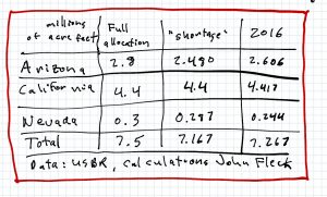
2016 Lower Basin water use
But in order to try to avoid mandatory cutbacks – a “shortage” declaration – we’re already seeing water users in Arizona and Nevada voluntarily cutting back. My rough estimate, based on munging together a couple of US Bureau of Reclamation datasets*, is that US Lower Basin water use this year will be about 7.267 million acre feet, the lowest it’s been since 2005. In other words, in order to avoid being forced to use less water, a number of the big water agencies are voluntarily using less water.
The current forecasts for the end of 2017 are close enough to the magic 1,075 line that a continuation of this year’s voluntary conservation efforts could very easily prevent a mandatory “shortage” declaration again next year.
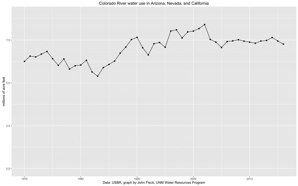
* a note on methods: Based on the keen observations of Tony Davis about the USBR’s methodology for forecasting water use, I’ve done some supplemental calculations here to come up with my own revised estimate of how much water will be used this year. It’s based on the official USBR forecast, combined with estimates from the agency’s 24-month study which capture anticipated diversions by the Metropolitan Water District and the Central Arizona Project that don’t show up in the official forecast until later. It’s still not “right” (danger, journalist doing math!) but close enough. Here’s the data graphed back a while:
Based at the Desert Research Center in Reno, Kelly carried the title of “Regional Climatologist” for the western United States, and it was a title that he lived. For decades as a newspaper reporter, I’d do the ritual of calling Kelly only to get his standard voicemail detailing his travel schedule for the week. He spent as much time on the road traveling the West talking to people as he did in his office.
The grueling travel schedule was purposeful. No scientist I know more fully lived his life at the interface between his science and the people who needed to use it. As a result, Kelly was the most skilled and gifted science communicator I know – because in significant part he spent his time listening to the people who needed to use his science, understanding what they needed.
His 2002 BAMS paper is a classic because it is informed by the deep understanding that came from those years of listening. His knowledge of the science, as an active researcher on western climate issues, was unsurpassed. But it was a science always informed by what the community needed of it.
Kelly died yesterday at his home in Reno. The outpouring of love the last 24 hours has been amazing. He was enormously generous with his time and intellect. He will be deeply missed, but the enterprise we are all engaged in is immeasurably richer for his contributions.
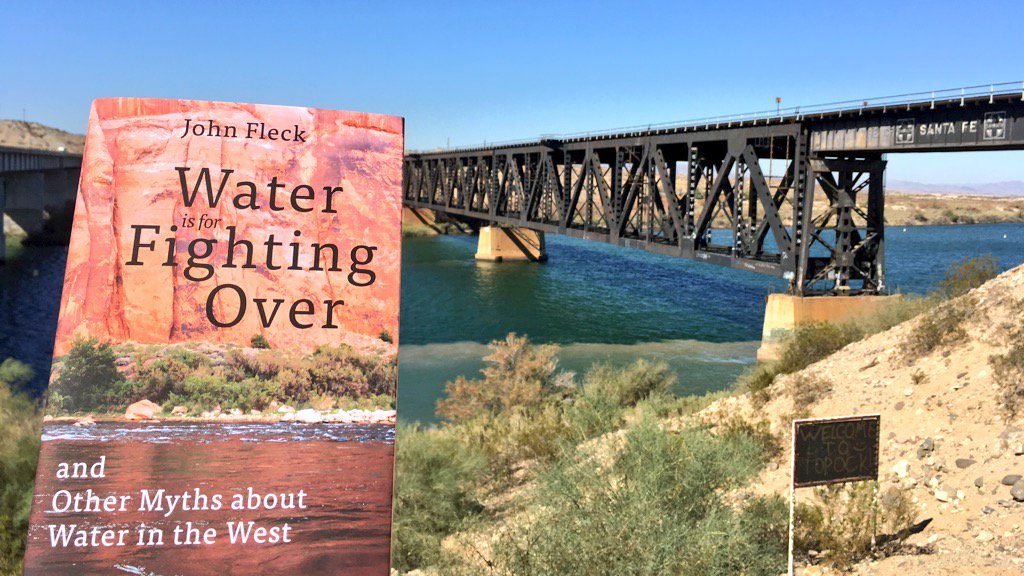
People have been sharing pictures of my book as it travels to interesting places. This makes me so happy.
Today Michael Thomas Bogan, desert fish and other aquatic critter researcher (don’t snicker, that’s a thing, desert fish are really important!) at the University of Arizona shared this one:
Folks in Nevada today are celebrating the 80th anniversary of Hoover Dam’s sort-of-semi-official power production.
Hoover Dam is such a dominant feature on the history of the west in the 20th century that it’s fun to contemplate what people thought about it before it happened. One of my fascinating side trips when I was researching my book was spent reading contemporary accounts from the vantage point of a nascent Las Vegas, a desert city built around some springs that was one of a hundred minor rail stops in the West until the 1920s:
The accident of Las Vegas’s geography, just miles away from the deep canyons of the Colorado River, was about to change that. The untouchable water was within reach, but the Las Vegas of the 1920s could not begin to grasp its implications.
“Action of 7 States Means Millions to Las Vegas,” the Las Vegas Age proclaimed on November 25, 1922, as it formally announced completion of the Colorado River Compact. The millions would come from building a dam that, thanks to “the Hand of Destiny,” would surely be built at the ideal dam sites in the canyons southeast of town. The Age
also trumpeted the importance of cheap power, which would help Las Vegas compete with big industrializing cities back East. If any thought was being given to the water supply a new dam might provide, the newspapers of the day did not mention it.
As I’ve written and spoken about many times, you can always begin to understand a city by considering its water – London falling at the point in the Thames estuary where it was first practical to land a boat headed upriver, for example, or New York as a port at the mouth of the Hudson. For Las Vegas it is clearly the Colorado, but in ways strange.
The leaders of Las Vegas imagined electricity to power factories and industry. Modern Las Vegas has made rather different uses of that power. They didn’t seem to think much at the time about the water at all.
In the 1908 case, Winters v. United States, the court ruled Indian tribes are entitled to sufficient water supplies for their reservations. But the Supreme Court has never specified whether those so-called “Winters rights” apply to groundwater in addition to surface water.Ian James writes about a fascinating case now making its way through the California courts:
Lawyers for the Coachella Valley’s largest water districts and the Agua Caliente Band of Cahuilla Indians presented their arguments to a federal appeals court in a water rights case that could set a precedent for tribes across the country.
The case hinges on the question of whether the Agua Caliente tribe holds a federally granted “reserved right” to groundwater beneath its reservation in Palm Springs and surrounding areas.
This case connects two really interesting gaps in US water law.
The first is the connection, or lack thereof, between groundwater and surface water. The law varies from state to state, but in many places the two types of water are treated separately under the law, even though they are clearly connected hydrologically. (Abrahm Lustgarten explains the disconnect here.)
The second gap is our inability to live up to the legal promises made when native communities were relegated to “reservations”. The word here needs to be considered carefully. The US Supreme Court in 1908 ruled that when the land was set aside for those native communities – the word is “reserved” – along with that land was the implicit legal right to use the land. Because without water, land in the arid West is substantially less useful. As James explains:
In the 1908 case, Winters v. United States, the court ruled Indian tribes are entitled to sufficient water supplies for their reservations. But the Supreme Court has never specified whether those so-called “Winters rights” apply to groundwater in addition to surface water.
The case in question here involves the Agua Caliente Band of Cahuilla Indians near Palm Springs. The implications stretch across Indian Country.