Working landscapes

PHOENIX – Drive south on Interstate 10 out of the Phoenix metro area, past Ikea, and the city ends abruptly, a sharp line between development and desert.

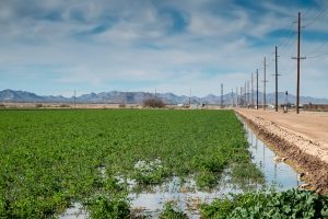
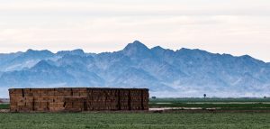
alfalfa fields, Stanfield-Maricopa Irrigation and Drainage District

Given its reputation for sprawl, Phoenix (when I say “Phoenix” here I’m talking about the whole metro area, not just the city itself) is remarkably compact. The realities of building a city in the desert – specifically the need for water – make it hard for a city to dribble beyond its margins. “The plumbing necessary to deliver water in support of people,” Grady Gammage wrote last year in his fascinating book on sustainability and Phoenix, “means that development in the desert is a phenomenon of concentration. A desert dweller cannot simply settle wherever he wants, drill a shallow and cheap well, and set up a subsistence farm. He needs access to communal systems.”

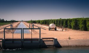
On the south side, the line is particularly sharp, as a spreading city bumps up against the Gila River Indian Reservation. But head southwest on Arizona 347 and the Sonoran Desert soon gives way to a working landscape. The Gila River Indian Community has turned its water rights into lush patches of farmland, as have the Ak-Chin, their neighbors to the south. And the Ak-Chin farmland blends seamlessly into the Maricopa-Stanfield Irrigation and Drainage District.

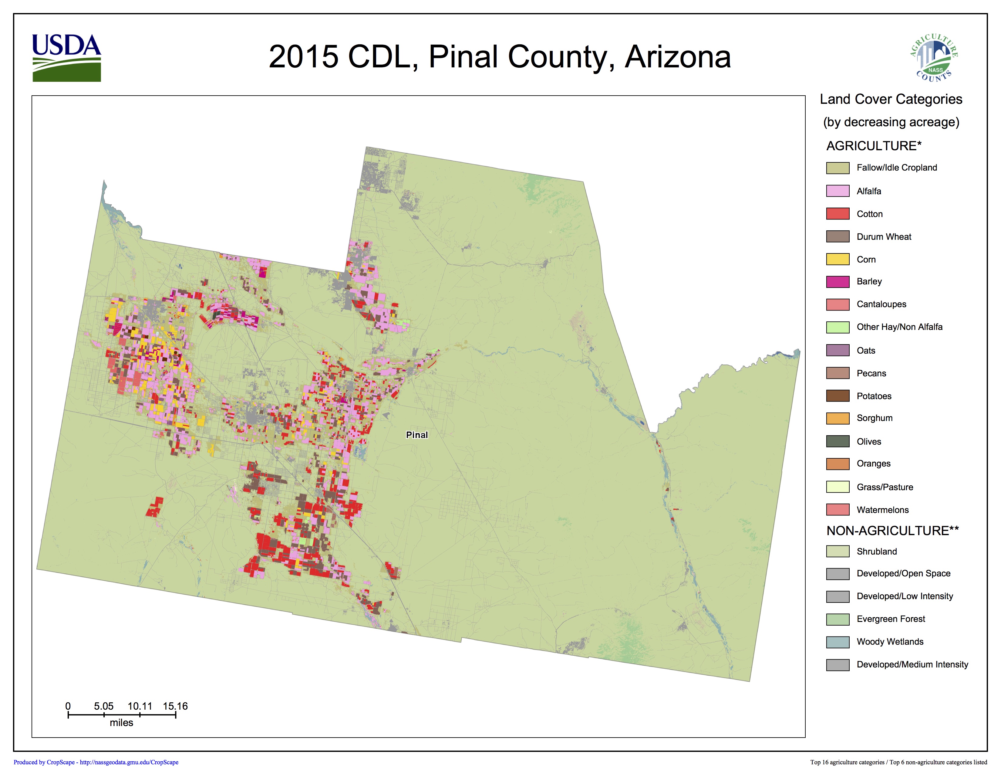
Pinal County crop coverage, courtesy USDA Cropscape

I’m in Phoenix this week for some meetings and to talk about my book, and I carved out some time to visit Pinal County, the stretch of mostly agricultural land that sits astride Interstate 10 between Phoenix and Tucson. When I say “mostly agricultural”, we’re speaking in relative terms here. It’s mostly desert, but to the extent there’s a human imprint, it comes in the form of alfalfa, cotton, and wheat, on Gila Indian, Ak-Chin, and Maricopa-Stanfield land.

At one point I pulled off to look at a recently irrigated alfalfa field and scared up a flock of sandpipers. They may have been yellowlegs, I didn’t get a good look, but as I stood taking pictures I heard the unmistakable squawking of killdeer, a bird from home, a call I recognize. There were a few dozen of each, lunching in the freshly watered landscape.

I tend to take for granted the categories of “nature” and “not nature”, but I’m intrigued by the conceptual blurring created by a flock of sandpipers in an irrigated alfalfa field and what that says about these coupled human-natural systems and the stories we tell about them. The old ecosystem services of a riparian wetland have been replaced by this alfalfa field. What does that mean?

In general, the “Sun Corridor” (the “megapolitan” region that includes both greater Phoenix and Tucson) has followed a pattern of evolution from old agricultural land to city. Because the urban development generally uses less water than the farms it replaces, this has simplified the region’s water problems – ag-to-urban water transactions by way of real estate deals rather than water policy maneuvering.

But a few significant agricultural regions remain in the land around Phoenix – the valley of the Gila River out west of the city and Pinal County to the south. These remain very much working landscapes – this is primarily agriculture as a business, not “custom and culture” farming. It is a landscape defined by:

  • agricultural economics, which determines which crops will likely be grown (the future of dairy here seems especially huge)
  • water policy questions – who gets how much water?
  • the law and policy around Native American rights to their own land and self-determination, and the resulting choices those sovereign communities make both about their own land and in their relationships with the communities around them
  • a changing climate
  • the changing shape of the economies of greater Phoenix and Tucson

All these things mash up together to create the future of that landscape. Seems like there’s a good story in here somewhere.

Throwback Thursday: the 1885 Riverside Citrus Fair

citrus displays at the 1885 Riverside Citrus Fair, Riverside, California, via Calisphere

Starting to think about what my next book might be, I’ve been reading about the history of citrus agriculture in the Southern California of my birth. My interest, in terms of the book, is the way the evolution of irrigation technology and governance maps onto the working landscape that was, for a time, the richest agricultural region in the country before evolving into one of the planet’s great megacities.

This whole marketing schtick – the citrus fairs, the romance of the orange crate labels – is a bit of a side road, but a fun one. Or maybe not? It’s impossible to separate the economics of citrus marketing from the change on the landscape that resulted.

Ignore this quite encouraging Rio Grande runoff forecast

It is only January. We have months and months of snow season left, which will determine whether we have a good runoff year on New Mexico’s Rio Grande.

So you should in no way click obsessively on the snowpack map every morning while you’re having your first cup of coffee. I repeat, do not click. Even worse, please don’t click to see if the NRCS has updated its automated daily regression forecast today. (For the record, they haven’t done this yet this morning.) And please don’t obsessively tweet about the latest numbers.

So please ignore the following excellent news out this morning from the NRCS:

  • median forecast for March-July runoff at Otowi: 715,000 acre feet, 99 percent of normal

UC Davis irrigation experiment shows big increase in alfalfa yield per acre foot of water

Cleverly managed deficit irrigation (when you significantly reduce water applied during the hot part of the year) substantially increased yield per unit water applied in a new study by researchers at UC Davis. In controlled side-by-side field experiments, Dan Putnam and his colleagues demonstrated that if you do it right, a big reduction in water applied will result in just a small reduction in yield.

The technique involves full irrigation for a good part of the year, but an irrigation cutoff in the hottest part of the summer. That’s the time of year when alfalfa can drink up a lot of water for not much additional yield. This reflects something farmers have long known – that alfalfa is a sturdy crop, offering resilience in a drought. When summer supplies run low, the plants hunker down. Yield drops, but they don’t die.

I talked about this in my book:

This opens up interesting policy options. If, say, the water saved was sufficiently valuable to a municipal water user to compensate the farmer for the lost yield in return for sending the saved water off to the city, you’d have the room for a deal that keeps the land in production and the farmer in business while also providing water to the city.

This sidesteps the biggest criticism of agriculture-to-urban water transfers—that they dry up land and community livelihoods. “Buy-and-dry” has become an epithet in the Colorado River Basin, and deficit irrigation provides an alternative if we can get the institutional arrangements right. By one calculation, widespread use of intentional deficit irrigation in alfalfa fields in Arizona and Colorado irrigated with Colorado River water could save nearly four times as much water per year as the annual consumption of the Las Vegas metro area.

The citation for that last bit leads to Michael Cohen and colleagues’ 2013 analysis of Colorado River Basin agriculture.

Beneath Wichita, a recovering aquifer

At least one community in the midwest has found a way to protect its dwindling aquifer:

Groundwater levels were generally higher in January 2016 than they were in January 2015. On average, in January 2016, groundwater levels in the shallow part of the aquifer were about 3.4 feet higher and groundwater levels in the deep part of the aquifer were about 3.8 feet higher than in January 2015. The volume of water stored in the study area decreased by about 74,000 acre-feet between predevelopment (the time period before substantial pumpage began in the 1940s) and January 2016; increased by about 121,000 acre-feet between the historic low in 1993 and January 2016; and increased by about 61,000 acre-feet between January 2015 and January 2016. About 62 percent of the storage volume lost between predevelopment and 1993 has been recovered. The increase in storage volume from January 2015 to January 2016 can probably be attributed to less pumping by the city of Wichita and irrigators, more recharge due to higher-than-average precipitation, and higher volumes of artificial recharge in 2015.

Wichita, Kansas, and the communities around it realized in the early 1990s that their aquifer was in trouble. Conservation and aquifer recharge followed, to good effect.

This is from Status of groundwater levels and storage volume in the Equus Beds aquifer near Wichita, Kansas, January 2016, a report by the USGS and the City of Wichita. (Via Brett Walton’s Federal Water Tap)

Melons, lettuce, and other things about 2016

On a personal level, 2016 has been pretty great.

I published a book, Water is for Fighting Over: and Other Myths about Water in the West, which has been well received.

When I was struggling three years ago to move from the general – “I want to write a book” – to the specific – “I want to write this book” – I set down a very particular goal. I wanted to write a book about a path through a water-scarce future, I told the folks at Island Press, that appealed to both the agricultural irrigation community and the environmental left.

desert farming, Blythe Calif., February 2015 © John Fleck

This was pure bluff. I had no idea how to do it.

At that point I could see, dimly, that the story I was trying to tell was both descriptive and prescriptive, of a collaborative problem-solving structure that crossed those boundaries. It was descriptive in the sense that, in my reporting, I had seen people do it. It was prescriptive in the sense that I had come to believe it was the only path forward in solving our problems. The people who thought desert farming was crazily unsustainable and needed to die were not going to win. The people who thought leaving water in rivers for the environment was crazy were not going to win. The people who were going to succeed were the ones who figured out a way to let both groups be right. I had a very particular image in mind, of a thing I saw one evening in early 2014 – of a three people I know, two environmentalists and a leathery old ag water irrigation guy, sitting together in a hotel bar.

The environmental left part was easy – those are my people. But one of the deeply learned lessons of my journalistic career was the task of “entertaining” a diverse set of ideas: “to keep, hold, or maintain in the mind” (Merriam Webster) or better “to hold mutually; to hold intertwined” (Oxford English). So I spent a lot of time trying to understand the people, the culture, the values of desert farming.

citrus irrigation system, Yuma Mesa, © John Fleck

I think I finally got it when I was walking with a Yuma lettuce farmer to the parking lot behind his office. But for the fact that it was surrounded by irrigated valley land, it would have looked like any modern small business office building. And also the tractors out back. “That was my Dad’s first tractor,” he explained, pointing to an old one, carefully displayed. “And that was my first tractor.” The space to the right, he explained, was set aside to display his son’s first tractor.

The book came out Sept. 1, and I could not be more happy with its reception. Wired Magazine named it one of the must-read science books of 2016. Folks at the Audubon Society invited me to speak to their membership.

But thing that made me happiest? Two weeks ago at the annual meeting of the Colorado River Water Users Association in Las Vegas, CRWUA president Bart Fisher, a melon farmer from Blythe, Calif., in his opening remarks at the meeting’s plenary session, told folks they should read my book.

Thanks, Bart.

Have we halted Lake Mead’s decline?

Boulder Harbor, Lake Mead, December 2016, © John Fleck

There’s a “half full/half empty” joke in here somewhere.

The reservoirs of the Colorado River Basin are 49 percent full/51 percent empty right now (data pdf). Despite another bad runoff year, that’s pretty much exactly where they were at the end of 2015.

Let’s go with half full then, shall we? We’ve come within a couple of inches’ elevation of halting Lake Mead’s decline. It still shrank, and absent further action it will continue to do so.

But we are close, and we can see what “further action” looks like. As I write this on New Years Eve, it looks like Mead will end 2016 at elevation 1,080 feet and change above sea level, just a couple of inches below where it ended 2015. Maybe the experience of the last couple of years suggests “inexorable” is no longer the right word?

Annual elevation change, Lake Mead

The year-end number is still a record – the lowest since 1936, when they were first filling the big reservoir. (Despair?) But in a year with below average precipitation in the Colorado River Basin (89 percent of average into Lake Powell), this represents real progress in managing the system. “Normal” for the 21st century (the median) is an annual drop of 12-plus feet in the reservoir. It’s only gone up twice since 2000. Both times were unusually wet years. A year in which, despite sub par runoff, Lake Mead doesn’t keep dropping is a step in the right direction.

Looking at the basin more broadly, total storage at years’ end sits at 29.453 million acre feet, just a tad below 29.693 million acre feet last year at this time. This despite Upper Colorado River Basin runoff that was more than 1 million acre feet below average.

A few things are going on here:

  • Arizona only took 2.61 million acre feet of water in 2016, 93 percent of its full allotment.
  • Nevada only took 235,000 acre feet, 78 percent of its full allotment.

Over the last couple of years, the combined conservation efforts of Arizona and Nevada are equivalent to about 8 feet of elevation in Mead – water that is currently sitting in the reservoir.

Lake Mead also has benefited from “bonus water” released from Lake Powell upstream. Under a deal the Colorado River Basin states cut back in 2007, in some years extra water is released from Lake Powell down through the Grand Canyon to Lake Mead, in an effort to balance the contents of the two big reservoirs. That has happened the last two years, and the forecast calls for it again in 2017.

The latest projections for next year suggest Mead will decline again absent bigger conservation measures. With a larger water conservation deal close and probably inevitable, we seem close to turning that important corner. A year in which Mead only dropped two inches despite below-average runoff suggests that it can be done.

When people have less water, as I have previously written, they use less water.