“I just found this route a couple weeks ago….”

One of the great joys of bicycling socially is route sharing.

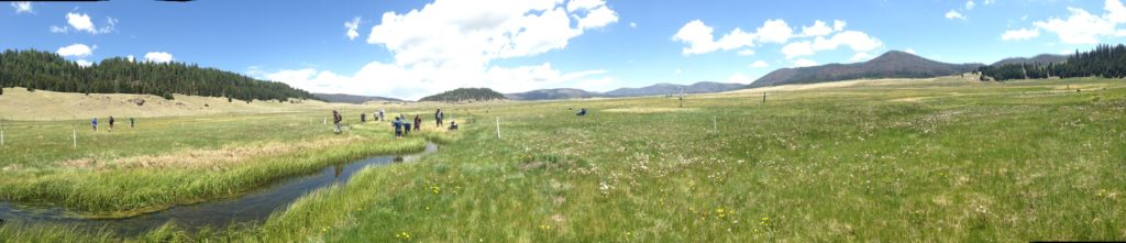
Albuquerque is a great bicycling city. We’ve got a nice network of trails that are completely separated from streets, including one along the Rio Grande that runs the whole length of the metro area. We’re seeing more and more facilities on the streets as well – protected lanes, bike boxes, that green colored pavement that acknowledges that the bikes belong here too.

With my new job at the university, I can commute by bike – it’s close, and the neighborhood has a high density of cyclists, which increases safety because drivers are used to us. Lots of my students ride.

But inevitably, as you build new bicycle infrastructure, that infrastructure has to end somewhere. The network is increasingly interconnected, but there will always be gaps. “So how do you get from X to Y?” is a common conversation among cyclists – where do you cross Lomas, how do you get up from the river through downtown, and most importantly, always, where do you cross the freeway?

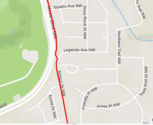
the trick to get from the “Powerline Trail” on Albuquerque’s West side to Atrisco

I still identify a lot of my rides with the people who shared their little tricks for stitching the network together. Last Sunday, my old friend Scot showed me where to “portage” across a big dirt patch to get from Tramway Boulevard to the bike trail that heads back down in my neighborhood. Today it was new friend Dan leading Scot and I through the zigs and zags to connect up the “Powerline Trail” on Albuquerque’s west side (it’s real name is something more poetic, but one of Dan’s tricks when the trail goes through a few awkward zigs and zags on the neighborhood streets was to watch the big overhead power lines – trails follow infrastructure).

The little kink in the route on the map to the right (yes, we are nerds, we GPS our rides) gets you from the Powerline Trail to Atrisco Dr., which you can then follow all the way back, with a few zigs and zags (thanks Dan and Scot!) to the Atrisco Neighborhood, down by the river. The city has a great bike system map, and Scot carries a paper copy. But the wisdom of the zigs and zags comes from the shared knowledge learned by a posse of Albuquerque riders working out the tricky bits and sharing what they learned.

The Copenhagen left

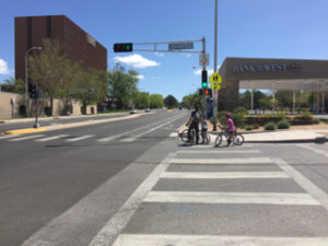
As we were passing under the railroad tracks on Tijeras-Martin Luther King Boulevard, we caught up with a dad riding the bike lane with his two young daughters. They were on their way to a birthday party. We dawdled and chatted before going our separate ways as the dad taught his daughters how to do a “Copenhagen left”.

Passing on the lore.

California’s remarkable resilience in the face of drought

We’ll be analyzing lessons from California’s drought for a while yet. But what I view as the most important lesson is already clear.

The L.A. Times’ Bettina Boxall, one of the state’s most experienced and respected water reporters, summed it up thus:

[O]n the whole, this intricately plumbed state proved to be surprisingly resilient in the face of what, by some measures, was the worst drought on record.

“We did remarkably well,” said Jay Lund, director of the UC Davis Center for Watershed Sciences.

Despite water shortages, agriculture — the state’s biggest water user — enjoyed record revenues in 2012, 2013 and 2014 thanks to soaring nut and dairy prices.

Though drinking supplies had to be trucked to some rural communities, the effect in most metropolitan areas was mainly limited to people boasting about every drop they saved, tsk-tsking at wasteful neighbors.

The water shortages barely put a dent in the state economy.

“How much reduction in the gross domestic product of California occurred because of a 25% reduction in urban water use? Almost nothing!” Lund exclaimed. “Nobody has even bothered to calculate it, it’s so small.”

slots still available for UNM Water Resources Program fall 2017

UNM Water Resources Program students at the Valles Caldera

We still have some slots available for fall 2017 in the University of New Mexico Water Resources Program.

When I left my career in journalism, it was for the chance to join a community of people at the University of New Mexico who are passionate about water. We’re looking for students who think that way too, who are interested in developing the skills and knowledge to help solve the problem of ensuring sustainable and resilient water systems in the West and around the world.

The program is fundamentally interdisciplinary. We’ve got students right now studying the complexities of climate dynamics with UNM’s Dave Gutzler; the challenge of wastewater reused with Caroline Scruggs; the complexities of water law with Reed Benson; the complexities of thinking through what we mean by resilience and how we achieve it with Melinda Harm Benson. The same students. Studying all of these things. We take “interdisciplinary” seriously. (And yes, your tuition includes not one but two Bensons.)

Our core curriculum includes a three broad survey courses.

Our introduction is called Contemporary Issues in Water Management, which I teach along with Bob Berrens, my predecessor as director of the Water Resources Program, with frequent cameos from Bruce Thomson, Bob’s predecessor. Bob’s an economist, Bruce is an environmental engineer, and I’m a former journalist turned professional water wonk. “An economist, an engineer, and a journalist walked into a bar, see, and….” As I said, we take “interdisciplinary” seriously. We cover a lot of ground in a course that’s rooted in an effort to tease out and make sense of water policy and governance is in all its messy complexity.

In the spring semester, students tie physical hydrology and human elements together in the development of a system dynamics model of a watershed. Working with hydrologist Jesse Roach and economist Jinjing Wang, the students this spring are building a computer model of the Gila River watershed in New Mexico to ask questions about human use of water in the region, including its economic and environmental components. Throughout the first two classes, I’m teaching communication at the interface between students’ technical work and the political/policy world in which they’ll be applying it. I’m convinced that understanding deeply how politics and politics work in real world settings is crucial to success in water management. This is my passion.

The third core course is a field course. Students learn to measure water, then spend several days up in the Valles Caldera doing a rapid watershed assessment. See picture above. ‘Nuff said.

With the core out of the way, we then dispatch our students across the campus, assembling what one of this years’ students smartly described as a “choose your own adventure” curriculum tailored to students’ professional goals and personal interests. We’ve got our tendrils in geography, law, engineering, biology, earth science, community and regional planning, and art. Yup. Art. As I said, we take “interdisciplinary” seriously. Water is no one thing.

Students’ capstone for their masters degree is a professional project, which in recent years have ranged from the use of remote sensing to help water managers understand agricultural water use to a look at the prospects for adaptive management of environmental flows on the Rio Chama. This is the coolest part. Lots of examples of our students’ work here.

Know anyone who might be interested? Share this link, and/or have them drop me a line: fleckj@unm.edu. Details on the program here, and if you’re serious our detailed Program Guidelines are here in pdf with info on admissions requirements, prerequisites, and the path through the university bureaucracy.


Does Las Vegas have the most reliable water supply in the Colorado River Basin?

David Owen makes an interesting point in this New Yorker piece:

Just as proximity makes people think that Las Vegas is the principal cause of the decline of Lake Mead, it also makes them think that any further decline in the lake will be a problem mainly, or even only, for Las Vegas. But that isn’t true, either. When the pumping plant for the third straw is completed, Nevada will be the only lower-basin user with the infrastructure required to draw lake water from below the level known as “dead pool”—roughly nine hundred feet above sea level, the elevation of the lowest openings in the four intake towers on the upstream side of Hoover Dam. Approximately a quarter of the water remaining in Mead is below that dead-pool line and, therefore, untappable by users below the dam.

This is a fascinating reality. The “dead pool” scenario involves a Lake Mead so low that water can’t get out. But with really deep intakes, Las Vegas will be able to get water if anything is flowing in. At this point, physical infrastructure would trump the Law of the River, and we’d all be wanting to move to Las Vegas.

OK, maybe not that. (I kid, Las Vegas, I love you!)

The article is based on Owen’s new book, which I’m excited to read.

Opening the spigot on the Rio Grande

My friend Lauren Villagran had a lovely piece in this morning’s Albuquerque Journal about what happens when you turn on a river:

Unlike in Albuquerque, where the river is always wet, the wide, sandy bed of the Rio Grande is almost always dry in southern New Mexico below the Hatch Valley until irrigation season begins. Every drop of river water is allocated under a more than century-old treaty – to Texas; then Mexico, and to the onion, chile, alfalfa and pecan farms of southern New Mexico’s Mesilla Valley.

Chasing the river’s advance is a strange thrill, both magical and unsettling.

I’ve known that strange thrill, and she is right in both regards – it is magic to see a river return to its bed, but also unsettling to realize it is doing so in this way only because we periodically turn it off.

In California, another aquifer turns the corner

Ian James on new work by USGS researcher Michelle Sneed on the aquifer beneath the Coachella Valley, west of California’s Salton Sea:

Since 2010, she said, groundwater levels have either stabilized or risen in many parts of the valley, in large part due to replenishment of the aquifer at percolation ponds.

“Every well I’ve looked at, this is the story: Either water levels are coming back up or the water level declines have slowed down,” said Sneed, who spoke during a water forum Tuesday at the University of California, Riverside’s Palm Desert campus.

Sneed, whose latest research has yet to be published, said that while the ground has continued sinking in parts of the valley, the ground level has stabilized in many areas. And in some places, she said, the land surface has risen as imported water has seeped underground to replenish the aquifer.

Sneed has also documented how the ground is rapidly sinking in parts of the San Joaquin Valley, and she said she rarely has an opportunity to present good news about land subsidence.

as war turned to peace

Robert Fleck at Bad Kissingen, Germany, June 1945

Martin Reber, a distant relative, tracked me down to share this picture of my father, for which I will be forever grateful.

We don’t know much about it, other than the scrawled message on the back suggesting it was taken within a few weeks of VE Day as my father’s unit moved into Germany. Dad was an artist, who had hauled his paints with him through war and into peace. He had found a porch, to paint in the natural light.

I have written before about my life amid art – “art as a verb – a thing not that has been done, but rather a thing that people do.”

See how his right hand, his brush hand, is blurred.

the federal role in water infrastructure

There are several federal programs with a demonstrated success in making infrastructure-related investments that support sustainable water use, healthy rivers and facilitate much-needed public-private partnerships. These include WaterSMART at the Department of the Interior; the Rural Utilities Service program at the Department of Agriculture; and the Clean Water and Drinking Water State Revolving Funds at the Environmental Protection Agency (EPA).

Collectively, these and other programs that focus on conservation and watershed improvements are the backbone of making efficient and sound infrastructure improvements that address today’s water resource challenges….

Water resource programs across Interior, Agriculture, EPA and the Army Corps of Engineers (COE) are critical elements of an overall strategy to leverage significant non-federal investments to implement durable solutions that stretch limited supplies, improve watershed health, support economic activity and contribute to investments needed for aging infrastructure.

Unfortunately, the Trump administration’s recent budget framework threatens many of these programs with cuts or elimination at a time when it is most important to support the infrastructure needs of communities. While the details are still unclear, the proposed 31 percent, 21 percent, 16 percent and 12 percent cuts to the EPA, Agriculture, COE and Interior, respectively, leave little room to adequately fund important programs to address the needs identified by ASCE.

That is former Deputy Interior Secretary Mike Connor in The Hill, the whole thing is worth reading.

Why should I conserve just so those other guys can have the water?

This story is a bit of a garble, but it illustrates one of the central challenges in making water conservation deals in the Colorado River Basin.

Here’s how I explained it in my book:

Within the network of state and water-agency representatives working on Colorado River Basin problems, there is a clear recognition that eventually some sort of “grand bargain” will be needed that finds a way to reduce everyone’s water allocation. To keep the system from crashing, everyone will have to give something up. But each of the participants in that core network also understands the dilemma that follows: each must then go home and sell the deal in a domestic political environment that views the river’s paper water allocations as a God-given right.

The story describes a Glendale City Council discussion of leaving water in Lake Mead, at which one of that community’s elected representatives said this:

“We are conserving water only for it to be consumed by other states,” said Councilmember Lauren Tolmachoff.

World Water Day on the shores of old Lake Bonneville

Flying into Salt Lake City this afternoon, I noticed the old shoreline benches of Lake Bonneville, the great Pleistocene inland sea that once filled a big chunk of what we now call the Great Basin. The benches are these big flat topographic features a few hundred feet above the valley floor. One one, south of town, they’ve built a neighborhood, a modern repurposing. It’s one of those geologic features that’s dead obvious from the air, but harder to see when you’re on it.

I’m at the University of Utah for the Wallace Stegner Center 22nd Annual Symposium – Water in the West: Exploring Untapped Solutions. With an hour to kill before dinner, I walked up the hill behind campus where there are signs for the Bonneville Shoreline Trail, which traces the counter of the old shoreline bench here.

I ended up at Red Butte Creek, which emerges from a culvert on the southern edge of campus before winding down to the Jordan River. It’s a little creek, but with the big snowpack to the east it was running full.

Red Butte Creek, Salt Lake City

Happy World Water Day from the Red Butte Creek watershed, on the shores of old Lake Bonneville.