irrigating less

In 1940, Los Angeles County had 250,000 acres of harvested cropland. By the end of World War II LA County was, by far, the most agriculturally productive county in California. In the most recent Census of Agriculture, conducted in 2012, acreage had declined to just 40,000 acres and LA County was but a minor contributor to California’s agricultural economy.

Water is only one of the reasons. LA got an oil economy early, it developed a rich and complex urban economy, and as a result agriculture was displaced by other types of economic activity. But water is an important part of the story. Much of the region’s early agricultural economy was based on unsustainable levels of groundwater pumping. As William Blomquist documents in the sadly rare Dividing the Waters (for the short and far less expensive version, I talk about this in my book), a big part of what happened is an early realization of that unsustainability, and moves to adjudicate and manage the region’s groundwater basins.
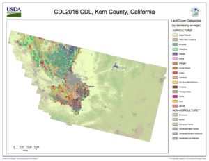
Kern County ag

In the evolution of California agriculture in the decades since, production greatly expanded in the state’s vast Central Valley. Kern County, at the heart of Central Valley ag, grew from 363,000 harvested acres in 1940 to 735,000 harvested acres in the 2012 Census. Accompanying the shift – unsustainable groundwater pumping.

It is inevitable, as Lois Henry reports in what is sadly her last water column for the Bakersfield Californian, that Kern’s irrigated acreage is going to decline. The proximate regulatory reason is California’s Sustainable Groundwater Management Act (“SGMA”, and yes we pronounce it “sigma”). But the deeper reality is that there just isn’t the water down there to keep pumping groundwater the way we are now:

In the best-case scenario, Kern could lose 185,000 irrigated acres.

SGMA or not, irrigated acreage in Kern and other places like it is going to decline. The question is how we manage our trip down the glide path, which is why I am so sad Blomquist’s book is rare and out of print. It provides some great examples of managing that process well.

a note on methods:

One of my UNM Water Resources Program students has been asking me about my research methods. I have had a hard time providing useful answers because my methods are chaotic. That is unhelpful. So let me document them here for this particular case.

  1. I was reading my Twitter water list with my morning coffee, and saw a link to Lois Henry’s column.
  2. The column
  3. Seeing acreage for Kern County discussed in the column, I turned to the Census of Agriculture, which has piles of agricultural data at the level of U.S. counties.
  4. In the upper left box on the 2012 Census of Agriculture is a pull-down menu for older census publications. This takes you to the USDA Census of Agriculture’s historical archive, which is a treasure trove of old ag data. For me, a dangerous, deeply addictive, wondrous trove of old ag data.
    1. Ag data is water data. Water data is ag data.
  5. I already knew the LA County water<->ag story (sorry Tom, not sure yet how to help you with this “already knew” bit), so I pulled up the 1940-1945 data for comparison purposes.
  6. For the picture, I used the USDA’s Cropscape tool

On the Colorado, the lowest water use in 25 years

Yes, a good snowpack helped us this year in the Colorado River. But the numbers are clear – reductions in water use made a far larger contribution to the good news on the river this year.

Projected year-end Colorado River storage

This week’s official Bureau of Reclamation declaration that we won’t have a 2018 Colorado River shortage got a lot of press, much of it attributing the success as Brandon Loomis did to a good snowpack in the Rockies:

A snowy winter in the Rocky Mountains helped Colorado River water users escape a shortage for the next year and likely for at least two more, federal water managers project.

But attributing it just to weather misses what I think is the most important part. Here’s Henry Brean:

Above-average flows in the Colorado River helped keep Lake Mead out of shortage for another year, but the real news is on the demand side.

Over the past year, Nevada, Arizona and California combined to use less than 7 million acre-feet of river water for the first time in 25 years.

Colby Pellegrino, Colorado River programs manager for the Southern Nevada Water Authority, said the decline in demand is proof that conservation efforts on the Colorado are making an impact.

The last time the three lower basin states combined to use less than 7 million acre-feet of river water was in 1992, when the region was home to roughly 7 million fewer people than it is now.

“We’ve successfully decoupled our economic prosperity from our water use,” Pellegrino said.

The numbers support this interpretation. Total runoff this year looks like it’ll end up at about 1.4 million acre feet above average. But total combined storage in Lake Mead and Lake Powell will end up about 2.7 million acre feet above average.

Total Lower Basin Colorado River water use – Arizona, Nevada, and California – is forecast to be 6.6 million acre feet this year, the lowest it’s been since 1992.

In the Upper Basin, in a year with supply 1.4 million acre feet above average, Lake Powell is rising by 2.1 million acre feet. In other words, even if this hadn’t been an above average year, we’d be ahead of the game.

This is a tricky time, because we can’t be complacent about this and use it as an excuse to relax and assume all is well and we can start taking more water from the river. See Udall and Overpeck on hot droughts and climate change for a reminder of the challenges ahead. But it’s a clear message that the things we’ve been doing over the last decade or more – read my book! – are moving us in the right direction.

What is it, exactly, about the Howitzers on Albuquerque’s Old Town Plaza that we should remember?

As is often my way, I wandered through Albuquerque’s Old Town Plaza at the tail end of my Sunday morning bike ride, stopping in the shade to enjoy the slow pace and people watching of the tourists mixed with Sunday church letting out.

That time they tried to bring the institution of legalized enslavement of human beings to New Mexico

On the west side of the plaza are a couple of replica Civil War-era canons, brass rubbed shiny by kids climbing and playing. There’s a plaque with a history that here in New Mexico we like to tell cute, about the westernmost battle of the Civil War, at Glorieta Pass, to the north of Albuquerque. Union soldiers routed a Confederate expeditionary force, and the fleeing Confederate soldiers buried their cannons in a field near what we now call Old Town so the Yankees wouldn’t get them.

The plaque’s mostly about how the Confederate officer who buried the cannons came back decades later, and they dug them up and made a display, and then later made replicas, which are what the kids have now rubbed shiny.

There’s nothing about why the cannons were here.

“A multi-ethnic democracy,” Yoni Applebaum wrote today in the Atlantic, “requires grappling honestly with the past.”

I sat for a while this morning and looked at the cannons and then, as I often do on my Sunday bike rides, wrote what you are now reading, in my head, tossing around the words and themes, as I rode back across town and up the hill to my house.

The plaque tells the story cute, about pieces of physical military hardware buried in a field, dug up, polished and mounted in a town plaza. There is no mention of the blood shed at Glorieta Pass. And, as often in the telling of this story, there is no mention of why those Confederate soldiers were here. But if we’re gonna grapple, it has to be with the reality that those soldiers were here to claim what is now New Mexico for the permanent legal enslavement of one group of human beings by another.

The Confederate troops who buried those cannons were from Texas. Here is the explanation Texans gave for joining the Confederate struggle:

She (Texas) was received as a commonwealth holding, maintaining and protecting the institution known as negro slavery – the servitude of the African to the white race within her limits – a relation that had existed from the first settlement of her wilderness by the white race, and which her people intended should exist in all future time.

I set the idea to write this aside until I got a text this afternoon from my child about a gathering this evening at 6 p.m. in solidarity with the people of Charlottesville.

It’s being held on the Old Town Plaza.

Collaboration to deal with thorny dairy water and waste problems

From Sandra Postel and National Geographic’s Freshwater Initiative, the story of a collaboration among a dairy farmer, an irrigation tech company, and an environmental group to improve water efficiency in growing dairy forage crops and reduce the impact of dairy waste:

A 2015 pilot of the system on a 40-acre (16.2-hectare) field of silage corn at De Jager Farms produced stellar results. Water use efficiency increased by 38 percent, nitrogen use efficiency by 52 percent, and corn yield by 15 percent.

While saving water was Ray’s initial motivation, the reduced leaching of nutrients into groundwater could have broad societal benefits if more dairies adopt this innovative system.

That time we built a dam in Glen Canyon

Lauren Steely, late of the Bren School, did a neat analysis a few days ago to help visualize Oroville Dam inflow data. She’s using R’s joyplot tool, which is all the rage these days as a new day to line up and visualize variability in datasets that have repeating patterns.

Like, for example, the annual hydrograph on a river.

Here is the way I had been looking at data from the USGS gauge at Lees Ferry, downstream from Glen Canyon Dam on the Colorado River:

Lees Ferry Gauge, Colorado River, data courtesy USGS

It tells a story. You can see the change when they completed Glen Canyon Dam in the early 1960s, and the huge flows in 1983 and for several years after. (See The Emerald Mile.) But it’s kinda squinty and dorky.

I’m not much of a programmer, but happily Lauren shared her code, which I adapted to my data problem. Here’s the same data in a joyplot:

joyplot of USGS Lees Ferry Gauge

The blank lines in the early 1960s are when they were first filling Lake Powell. The little nubs in the bottom right are the Glen Canyon Dam/Grand Canyon experimental environmental pulses.

The mountain ranges in the upper center are what a river looks like before you build the dams.

“springing condition subsequent”

Lawyers have the coolest language.

Consider the doctrine of prior appropriation. “Beneficial use,” the drafters of the New Mexico constitution explained, “shall be the basis, the measure and the limit of the right to the use of water.” It felt like poetry the first time I heard the New Mexico state engineer roll it out pit-a-pat, legal poetry, crisp and to the point. This is language that is doing real work, not just idle words, but language that is, to borrow from the field of legal geography, quite literally shaping the landscape. As with the best poetry, it says much, but also leaves us a trail of ambiguity as well. “I have seen the best minds of my generation….”

And so we have my new favorite legalism – “springing condition subsequent”.

Treaty of Guadalupe Hidalgo

I first heard this late at night last December in a Las Vegas bar, discussing the trick needed to sign a deal with Mexico over the Colorado River. The deal needed to go hand-in-hand with a parallel deal among U.S. states involving handling shortages and surpluses, and it was a chicken-and-egg problem. Each part – the international agreement with Mexico, the internal deal within the US – depended on the other to succeed.

Whichever went first had to be written in such a way that it was contingent on the approval of the other. As I wrote Tuesday, it looks like the Mexico agreement will go first, and is now very close to ready. It will take the form of a “minute”, tacked onto the 1944 U.S.-Mexico treaty governing the sharing of the Colorado River. And it concludes language that has been variously described as “contingent” or a “trigger” – a mechanism by which some of the terms of the deal only when certain conditions are met – in this case the subsequent approval of the parallel deal within the United States.

And that parallel deal? Let it be known as the “springing condition subsequent”.