Overcoming “use it or lose it” on the Colorado River

The “use it or lose it” problem in western water happens when water users who conserve are penalized by having the saved water simply go to another user.

A series of policy innovations over the last decade to overcome this problem are showing up right now in a big way in Lake Mead. In all, through these various mechanisms, more than 700,000 acre feet of water are being left in Lake Mead this year.

Without this water, Mead would probably be under elevation 1,075 right now, and we’d be having our first formal shortage declaration.

Not to alarm you further, but the Jan. 1 runoff forecast for New Mexico is really really bad

As I mentioned, this is the driest start to a water year in a century in Albuquerque. The preliminary Jan. 1 runoff forecast from the federal Natural Resources Conservation Service bears this out. The forecast, based on snow measurements, is stark. NRCS has 40 years of snow records, and for many sites, this is the driest start to a water year on record. In other words, it’s not just down here in the city. It’s up in the mountains of northern New Mexico and southern Colorado, where snowpack feeds New Mexico’s rivers.

With months of snow season yet to come, this should be considered very preliminary in nature. But the statistical probabilities suggest that, for many of New Mexico’s rivers, the chances of a record low year are higher than the chances of an average year.

Some numbers (all of these are median forecast numbers):

  • Rio Grande near Lobatos, near the Colorado-New Mexico border: 15 percent of average
  • Embudo Creek at Dixon: 16 percent of average
  • Rio Grande at Embudo:
  • Rio Grande at Otowi: 24 percent of average
  • Rio Grande at San Marcial, at the head of Elephant Butte reservoir: median forecast of essentially nothing, which is not plausible but the snowpack is so lousy that the model kinda breaks here
  • Pecos at Santa Rosa: 18 percent of average

A few things to remember.

First, it could snow a lot. These numbers could come up. The forecasts for the next month are “meh“, but this could happen.

Second, it could get worse. See previous link to “meh” forecast for the next month, and also recall that both the recent weather and the long term climate have trended on the warm side, which means that for a given amount of snow, paltry as it is, less water is ending up in our rivers.

Third, as I have written before, this is happening in the context of some very important changes in the approach to water management in New Mexico over the last few decades, in terms of conservation and diversification of supply, that leave our human water systems in a very resilient position. That resilience is likely to be very seriously tested this year.

A brief tutorial in how bad the Colorado River Basin snowpack is right now

Let’s look at the new Colorado Basin River Forecast Center graphic of projected runoff into Lake Powell, shall we?

Jan. 1, 2018 Colorado Runoff projection for Lake Powell inflows, courtesy CBRFC

The folks at CBRFC has done a lovely update of their graphical presentation. The story it’s telling right now – not so lovely.

Let’s take this step by step.

First, the green lines in the middle of the graph. Those are “average” for the April-July runoff, where the solid line is the mean, and the dotted line is the median. (UNM WRP students, there’ll probably be a question at some point on the quiz about the difference, and why you’d choose one or the other for policy discussions. Prof. Fleck is just kidding, right?)

The dark blue line is the automated forecast, based on current snowpack and some mathemagic the CBRFC uses that we all trust. The light blue band is essentially the error bounds, where the top of the bar says there’s a one in ten chance it’ll be that high, and the bottom a one in ten chance it’ll be that low.

Then, reading left to right, the X axis is the date of the forecast. So the fact that the blue line is below 4 million acre feet means that when they did their mathemagical incantations (I believe that’s the technical term) on Jan. 1, they concluded that there’s a wide range of possible runoffs, spread from just above 6 million acre feet to just above 2 million acre feet, with a midpoint a bit under 4 million acre feet of inflow into Lake Powell this runoff season.

But another way, this is really, really bad. Or, as one of the smart managers said in an email this morning, “sobering”.

Here’s the link, so you can join us in clicking obsessively while we worry.

Lake Mead ends 2017 not in shortage

Lake Mead ends 2017 at elevation 1,082.5, almost two feet above last year at this time. Lake Powell ends the year at 3,623, up more than 20 feet from a year ago. Combined storage in the two primary Colorado River reservoirs ends the year up more than 2 million acre feet.

Willow Beach on the Colorado River downstream from Hoover Dam, May 2017

This is in part the result of a good snowpack in the winter of 2016-17, but is more than that. Excess runoff into Powell this year from that snowpack was 1.14 million acre feet. The only way you get from there to an increase in storage of 2 million acre feet is by using less water. And that is perhaps the most remarkable piece of Colorado River news as we end 2017.

In the lower basin states of Arizona, Nevada, and California, this year’s preliminary estimate of total use – 6.77 million acre feet – is the lowest since 1987.

Consider:

  • Southern Nevada this year has taken just 81 percent of its full Colorado River allotment.
    • Its use of Colorado River water has dropped 25 percent since its peak in 2000, at time during which its population has risen 55 percent. This is not the result of a shift to groundwater, this is straight up conservation success.
  • Southern California (bolstered by a wet snowpack in the Sierra Nevada), is taking just 4 million acre feet of water.
    • That is its lowest Colorado River water use in the history of modern record-keeping on the river, which dates to the U.S. Supreme Court’s 1963 Arizona v. California decision.
    • Southern California’s use of Colorado River water this year is down 25 percent from its 2002 peak.
  • Arizona will use 2.5 million acre feet of Colorado River water this year, its lowest since 2005.

Part of this, of course, is the big Sierra Nevada snowpack. But it’s also driven by the remarkable decoupling of water use from population and economic growth in the arid southwestern United States. According to a new dataset of municipal water use published this year by the U.S. Geological Survey, total water use in the municipalities served with Colorado River water declined 7 percent from 2010 to 2015, even as population rose 10 percent.

Population is going up. Water use is going down. When people have less water, as I wrote in my book, they use less water.

If we were ending 2017 with Lake Mead’s elevation below 1,075, we’d be in shortage, there would be mandatory cutbacks, and we’d all be writing hand-wringing pieces about the looming apocalypse. The fact that it’s ending at 1,082.5 has largely gone uncommented upon, but if shortage matters, then the lack of shortage must be equally important.

Notes on sources:

Managing the Colorado River to use less, rather than take more

In the summer of 1931, as the Bureau of Reclamation was launching work on Hoover Dam, flows on the Colorado River dropped to what, at the time, were low flows unprecedented in the few decades’ records on the river. In retrospect it should have been a clue that there was not going to reliably be enough water in the Colorado River to meet the water supply numbers locked into law via the Boulder Canyon Project Act of 1928

Digging through archives yesterday afternoon for The New Project, I ran across this wonderful headline from the New York Times:

New York Times, Dec. 4, 1932

It sits atop a 1932 New York Times letter to the editor from M.J. Dowd, Chief Engineer of the Imperial Irrigation District, which even then I’m pretty sure was the largest user of Colorado River water. Down and his Imperial Valley community really wanted Hoover Dam – to protect from “the flood menace” (“menace” was a common word at the time to describe the river we all know and love).


With Lake Mead now hovering at low levels not seen since its first filling, shortly after Dowd’s optimistic missive, it is perhaps time for a rethinking of his confident premise.

Which, as Eric Kuhn points out in this piece by Luke Runyon on Colorado River “drought contingency planning”, seems to be what is happening:

Kuhn says the Drought Contingency Plan negotiations mark a change in how even the staunchest water managers, often criticized for a narrow focus on claiming as much water as possible and storing it in reservoirs, think about the Colorado River. In the past, he says, conversations were about who would claim the next drop of the river’s water.

“Now we’re talking about when we cut back, which we will probably have to, who’s going to take those cutbacks?” Kuhn says.

At the risk of putting words in Eric’s mouth (disclosure: We’re in the midst of writing a book together, so we’re quite literally in the midst of putting words in one another’s mouths, so to speak.) I think he’d agree that the pivot from conversations about claiming the next drop to talk about how to cut back have been underway since the 1990s. This stuff takes time, but as Eric points out, the current shape of the Drought Contingency Plan suggests most everyone (not all of everyone, knowing side eye glance at Utah) is on board.

New Mexico 2017 Water Year in Review

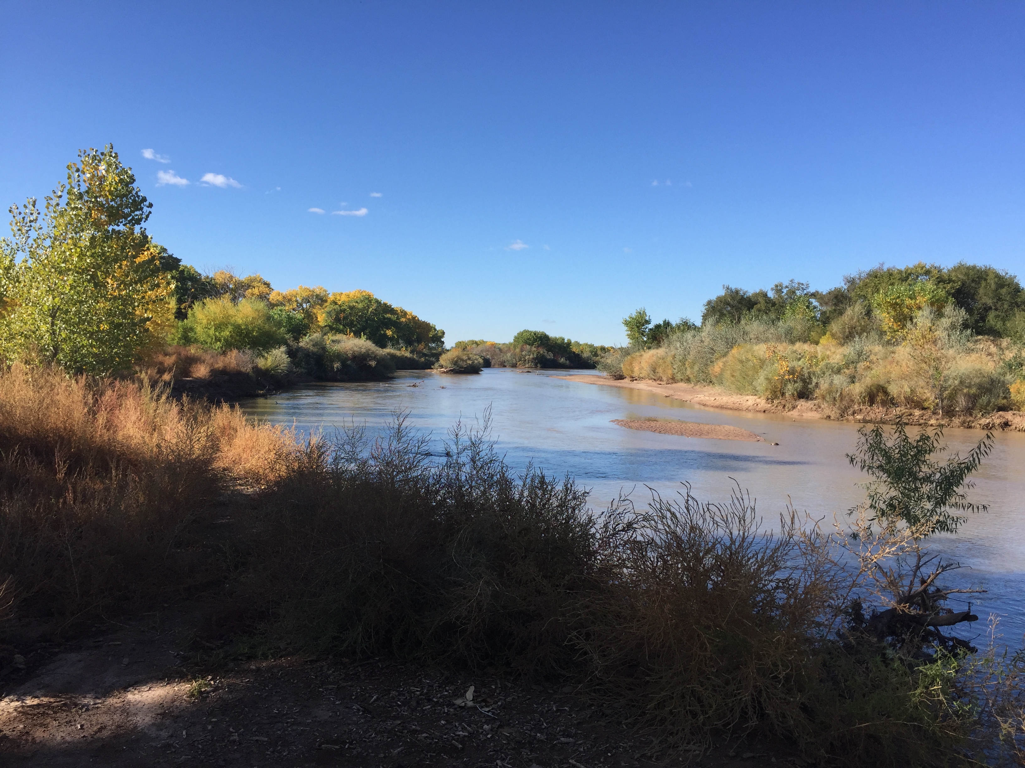
Rio Grande, Albuquerque, New Mexico, Oct. 20, 2017

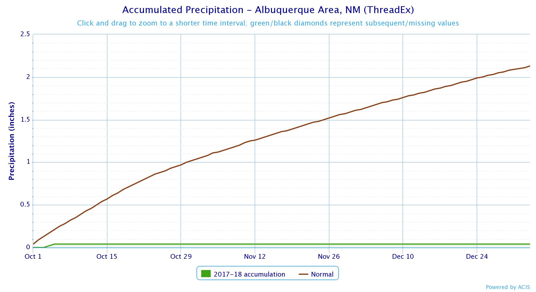
We’re up to 82 consecutive days without measurable precipitation at the Albuquerque airport, the 8th longest dry streak in more than a century of record keeping. And there’s nothing in the forecast out seven days, which is as far as it’s reliable to take it (butterfly effect and all). But OK, since you asked, the first glimmer of hope in the really-long-range-don’t-trust-them-but-this-is-just-a-blog-post forecast is Jan. 8., which would put this in the top five dry streaks on record.

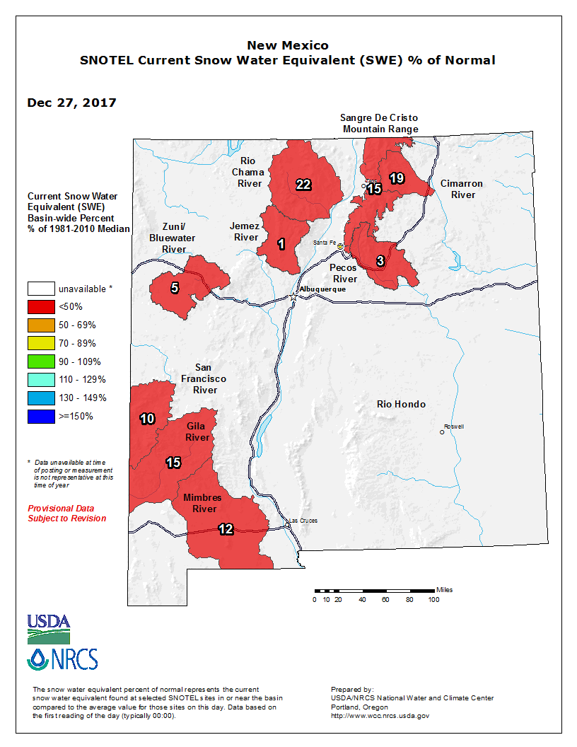
New Mexico snowpack, or lack thereof

Through yesterday, 2017 was tied for the warmest year on record in Albuquerque.

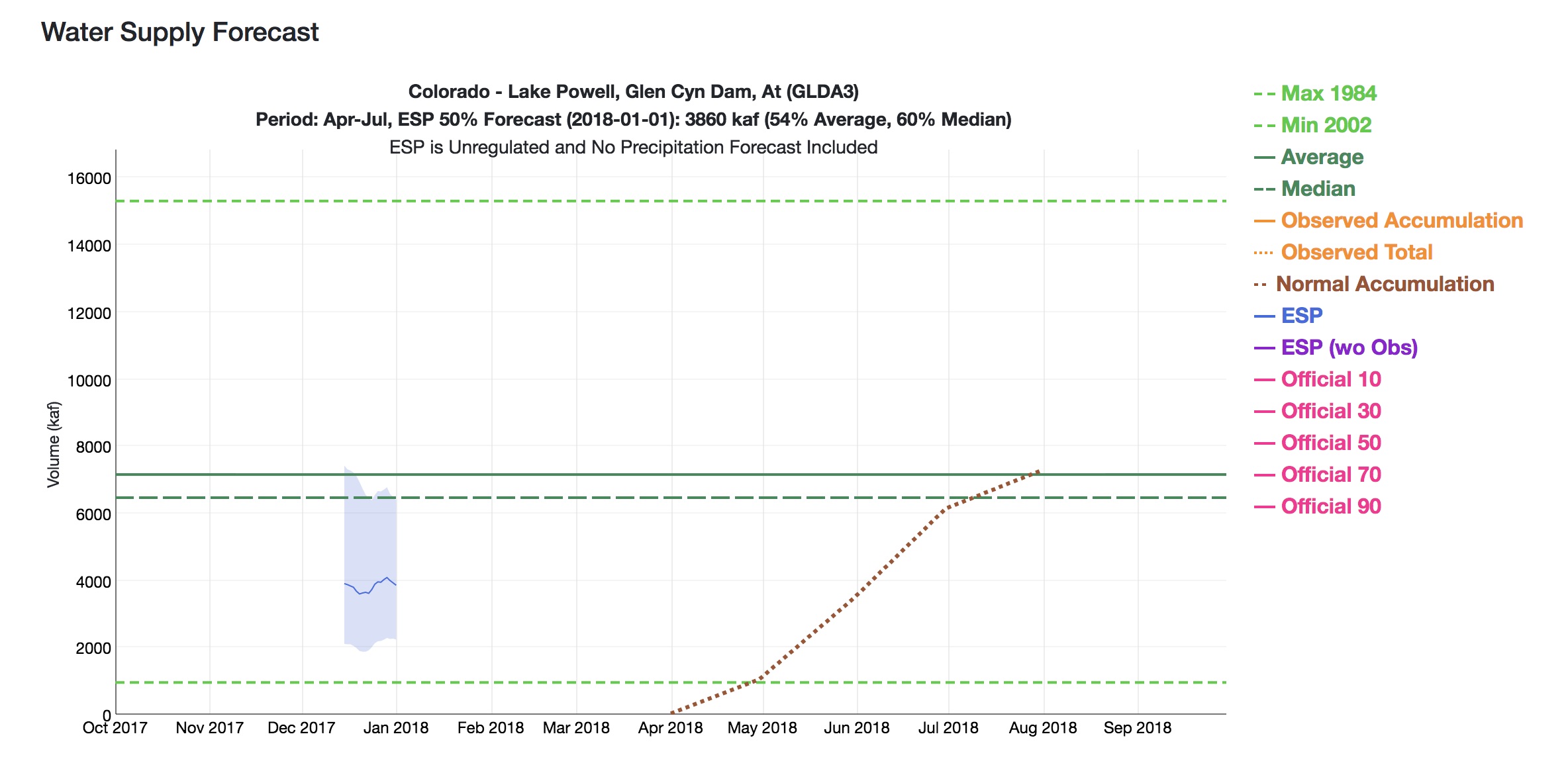
Snowpack in the northern mountains – important for water supply in the coming year – is lousy. The current regression forecast (an automated tool run by the NRCS to provide daily updates based on current snowpack) is just 34 percent of average runoff on the Rio Grande through central New Mexico. You shouldn’t stake a whole lot on forecasts done this early in the year (think of them as more like suggested possibilities – for the stats nerds the forecast at this time of year has an r squared value of 0.45) but neither should they be ignored. Every additional dry day makes it that much harder to catch up.

That said, however, we’re in remarkably good shape right now, the result of both a very good 2017, and significant water conservation and management efforts that leave our human water supply systems in decent shape to weather a bad snowpack.

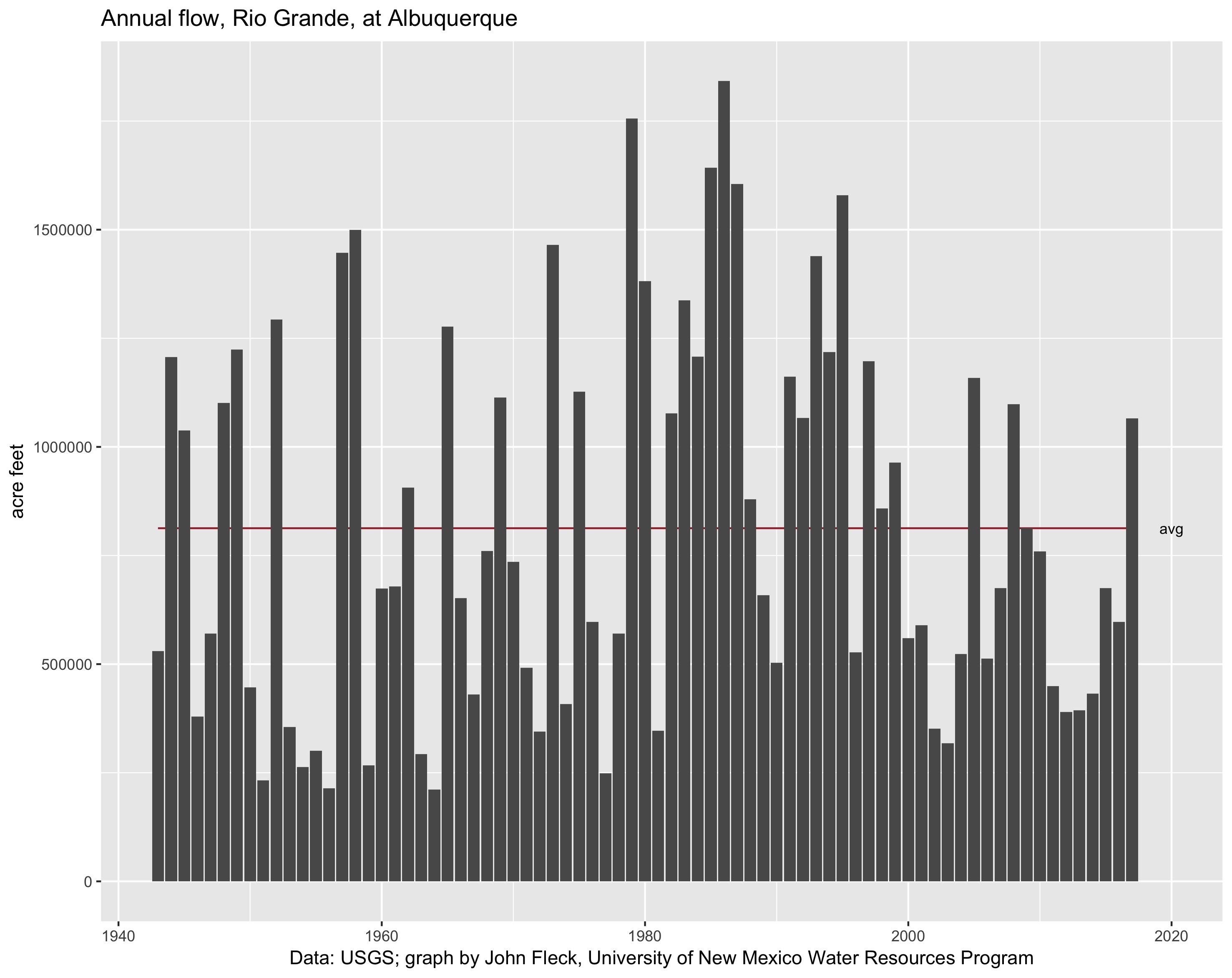
Rio Grande runoff, 2017

2017 runoff on the Rio Grande was outstanding – more than a million acre feet of water flowed past the Albuquerque gauge, beneath the Central Avenue bridge. But if you look at the graph to the left, you can also see how unusual a big runoff year is. This was only the third above-average year in the 21st century. “New normal” or whatever, this clearly requires an adjustment.

As a result of the big flow year, reservoir storage is in good shape. Elephant Butte, Abiquiu, El Vado, and Heron combined (the four primary reservoirs on the Rio Grande system in New Mexico) are up a combined ~300,000 acre feet over last year at this time. “Good shape” is relative here – Elephant Butte is still only 20 percent full, far from the glory days of the 1990s. But up is still up, and the Butte is up.

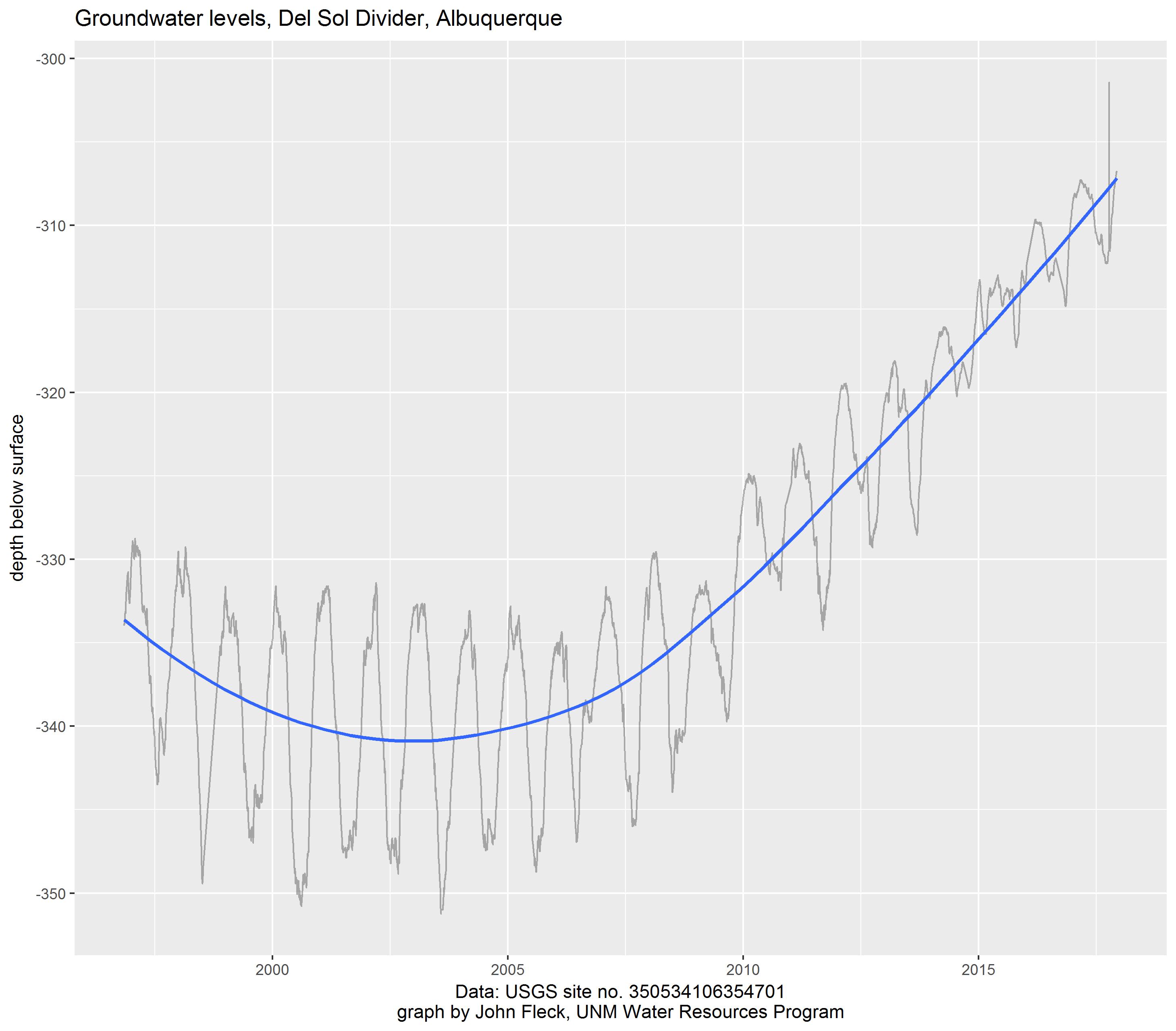
The most interesting thing, to me, is Albuquerque’s aquifer. This is the vast pool of water beneath the metro area, on which we’ve depended for much of the city’s modern life. A shift away from groundwater pumping to the use of surface water from the Colorado River Basin (via the San Juan-Chama Project), combined with significant conservation measures, have led to a rebound that seems unmatched among major urban aquifers in the western United States. Modeling done by the New Mexico Office of the State Engineer suggests aquifer storage is rising by 20,000 acre feet or more a year. Beneath my house, it’s risen more than 30 feet since our 2008 water management shift began.

Albuquerque’s rising aquifer

But that’s the human part. With reservoirs and aquifers and pipes and pumps, the humans will do OK even in the driest of 2018s. The natural systems, not so much. Expect low flows on the Rio Grande to make life very tough for the fish and riparian ecosystem. A year as dry as this is very tough on our mountain forests. And rangeland, whether for natural critters or grazing cattle, could have a very tough year.