For central Arizona farmers, coming to terms with the reality that a Colorado River allocation is not an entitlement

As Arizona wrestles with the reality that its Colorado River supply as measured in actual wet water rather than the “paper water” doled out by the Law of the River, we’re getting a lesson in the difference between an “allocation” of Colorado River water and an “entitlement”. The place to watch this play out right now is in Pinal County, the stretch of rural desert dotted with cotton fields and alfalfa between Phoenix and Tucson.

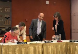
We’re hearing a lot of talk coming out of Arizona about a collaborative effort to settle conflicts and move forward in the lead-up to a public meeting scheduled for Thursday (June 28, 2018) in Tempe. Bret Jaspers characterized what’s happening now as a “reboot” of the tortured relationship between the Arizona Department of Water Resources and the Central Arizona Water Conservation District, the agency that manages deliveries of Colorado River water to central Arizona.

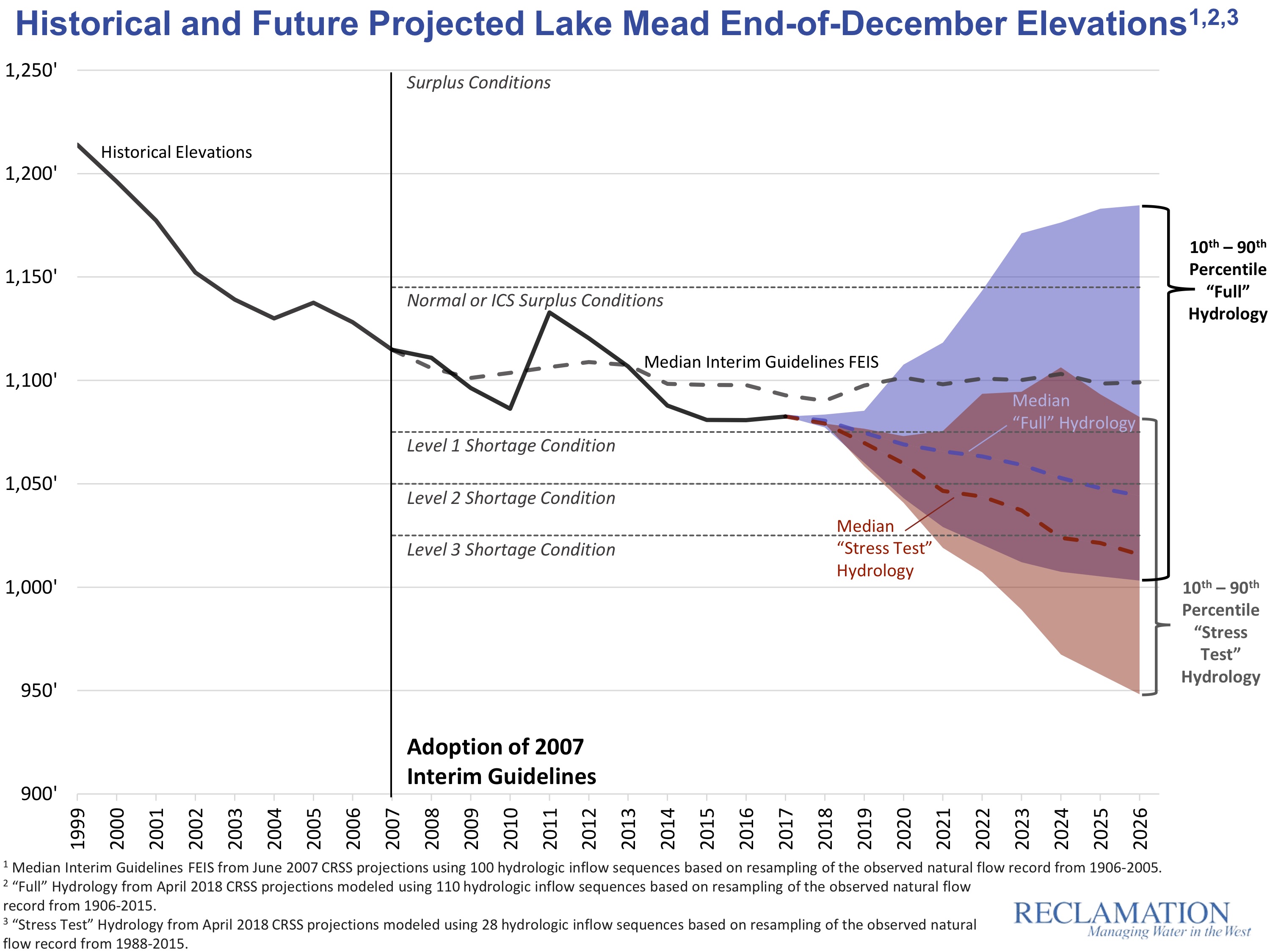
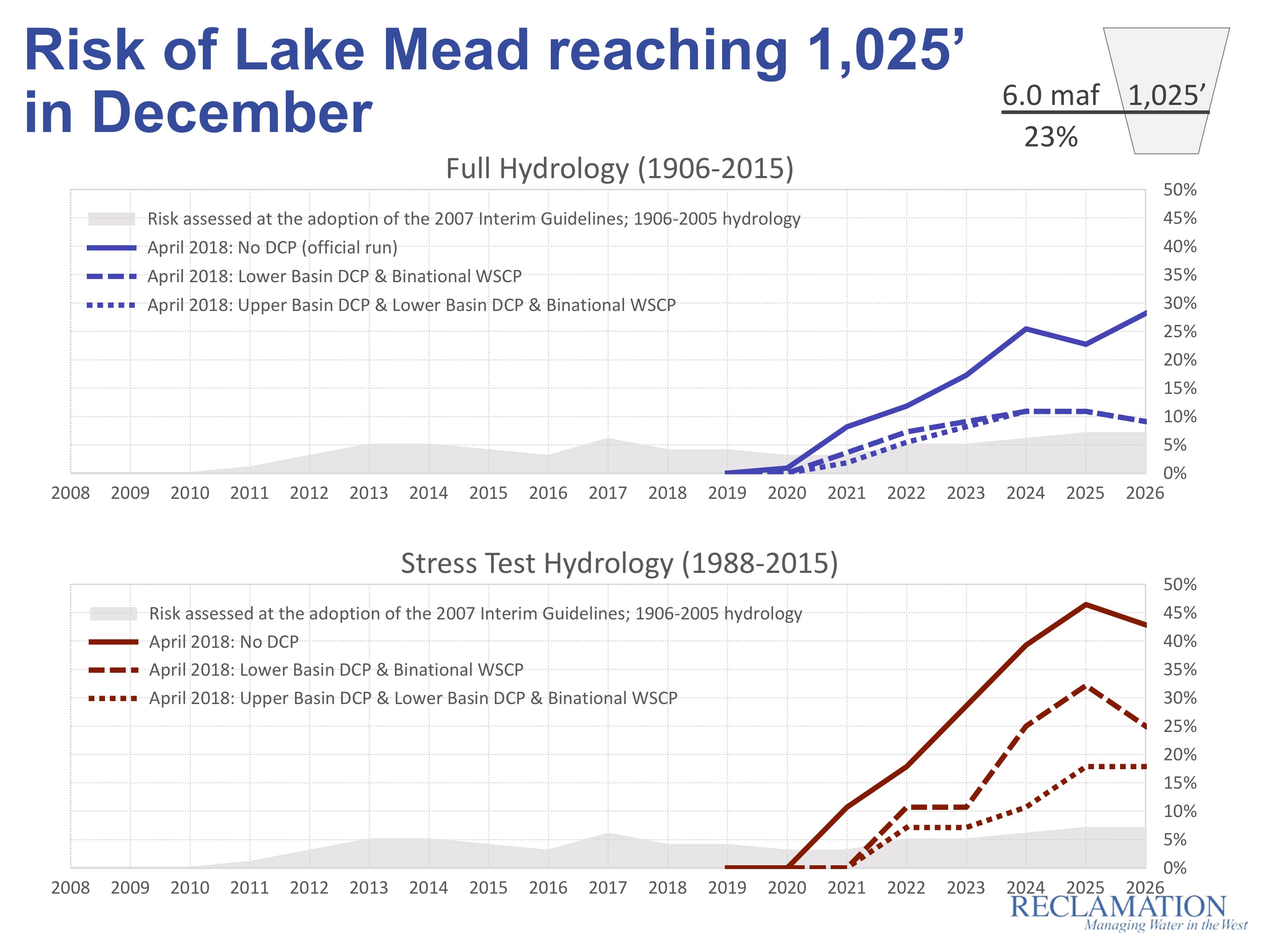
The meeting will be held in Tempe and live-streamed on the Internet. Commissioner of Reclamation Brenda Burman will be speaking to, in the words of the Arizona Department of Resources “discuss the risks to the system” which, as I wrote about a couple of days ago, involve crashing Lake Mead kinda soon.

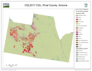
Courtesy USDA Cropscape. Red is cotton, pink is alfalfa

Pinal County is not exactly prime desert farming real estate, lacking the ready access to Colorado River water that you see in the valleys of Yuma, Imperial, Palo Verde, or on the Colorado River Indian Reservation. With little surface flow and an aquifer that cannot sustain farming in the long run, the only real alternative is imported Colorado River water via the Central Arizona Project, the canal that pumps water up from the Colorado River. But that is very expensive water, tough to afford without subsidy if you’re growing alfalfa and cotton.

And so subsidize we have (see this from Michael Hanemann for a history of CAP subsidies). Everybody’s irrigation water is subsidized in the West, but the Pinal County farmers’ water is subsidized a lot. Here’s how:

For the purpose of understanding Pinal County’s role in the current discussions, the key subsidy to look at is the deal signed by the counties’ ag interests in 2004 as part of the Arizona Water Settlements Act. Faced with high water costs even under the then-existing subsidy regime, the water districts signed a deal to essentially give up stronger water rights to free up water to meet Indian water rights settlement in return for yet more subsidy. Here’s how CAP explains it:

Irrigation districts that relinquished their long-term CAP entitlements under the terms of the Arizona Water Settlement Agreement were relieved of their federal distribution system debt—often referred to as 9(d) debt. In addition, CAWCD agreed to provide a pool of excess CAP water, subject to availability, to the relinquishing subcontractors at energy-only rates through 2030. This pool, referred to as the Agricultural Settlement Pool, was sized at 400,000 acre-feet initially, declining to 300,000 acre-feet in 2017 and then to 225,000 acre-feet in 2024. (emphasis added)

In return for what has been estimated at $343 million in subsidies since the deal was signed in 2004, the Pinal County farmers agreed to cheap water when it was available, but importantly this water was subject to availability. If water runs short, they’re among the first to see their supplies cut. The farmers were compensated in return for taking on greater risk. At least that’s the way the rules are written, and that’s the deal the farmers’ representatives cut, to the tune of about $25 million per year in subsidy – from the taxpayers of the greater Tucson-Phoenix area to the farmers of Pinal County to grow mostly cotton and alfalfa.

But the conversation right now, as Arizonans struggle with how to deal with shortage on the Colorado River, suggests that as that “subject to availability” shifts from the abstractions of white papers and legal documents to a risk of actual wet water cutbacks, thinking about the Pinal County farmers has shifted to treating that water as an allocation of water subject to availability based on the variability of the system (the way the classic structure of prior appropriations works) to an entitlement to a firm supply. The resulting discussions involve considering whether farmers should be compensated should supplies run low and they can’t get the water. Here’s the key bit from Bret Jaspers’ KJZZ piece last week, quoting Central Arizona Project general manager Ted Cooke:

One sticky subject is what to do about farmers in central Arizona, who would take a big hit under the current rules.

“How do we find a way to make things less painful for them?” Cooke asked. “Not completely painless, but less painful.”

This is not the only issue to be sorted before Arizona comes to terms on a Colorado River Drought Contingency Plan (or my new favorite moniker, a Use Less Water Plan – ULWP, pronounced “uhlp”). The Pinal bit is one piece of a deeper argument over who in Arizona gets to decide what happens to the state’s “excess” Colorado River water (an increasingly weird term).

But the fate of Pinal County farmers gets to the heart of our struggle to figure out how to live within a shrinking Colorado River supply.


New USBR modeling suggests a bigger risk of Colorado River shortage than y’all might think

The conventional calculation of Colorado River shortage risk, which people like me frequently report, shows a 51 percent chance of Lake Mead dropping into “shortage”, below the magic trip line of elevation 1,075 at which mandatory cutbacks kick in, in 2020. But a new approach to modeling risk, which lots of folks (*cough* me *cough*) think more accurately represents the changing climate, shows a significant risk of a much quicker drop in Lake Mead’s levels, blowing quickly past 1,075, with a greater than 50 percent chance of dropping below 1,050 sometime in 2020. Absent actions to reduce water use, Lake Powell has a greater than one in four chance of dropping near power pool (the level at which it could no longer generate electricity) by the mid-2020s.

It is to the Bureau of Reclamation’s credit that they’re not only running the new modeling methodology in parallel with the more traditional approach, but that they’re doing this in a very public way, presenting both last week at the Basin States principals meeting in Santa Fe as part of the federal effort to get negotiations over water use cutbacks back on track.

Here’s the Mead graph showing the traditional modeling approach (the blue) and the newer “stress test” (shown in red):


I like this graph (kudos to Carly Jerla and the other wizards at the Bureau for coming up with such a clear visualization) because of how intuitively it shows how different the answers are when you use the two different approaches. Especially visually striking is the probability “cloud” showing the statistical range of possibilities. The old blue approach shows a decent chance of wetness refilling reservoirs. The newer red approach not only offers no such blue bits of optimism, but shows some statistically credible chances of Lake Mead seriously tanking very soon.

The difference between the two modeling approaches gets to the heart of the importance of the “period of record” you use to analyze river flows in support of decision-making.

The traditional (blue) approach uses historic river flows from 1906 to 2015 as the basis for a statistical simulation of the range of possible futures given current reservoir levels. This is classic “stationarity” – assume the future will be like the past. The specific model then uses what’s called the “index-sequential method” (ISM), which is a bog standard way of modeling the statistics of river flows.

The new approach (red), which has come to be known as the “stress test”, is based on the view of some water managers and scientists that the old full-record approach is understating risk, because the past climate – especially in the case of the Colorado River that exceptionally wet first quarter century of the record – is putting more water in the river in your simulations than we can realistically expect any more because of a warming climate. The stress test still uses the ISM, but instead of the full record, it uses 1988-2015, which seems more like a modern climate than the full thing back to 1906.

the debut of the “stress test”

The “stress test hydrology” was pioneered by Eric Kuhn of the Colorado River District and John Carron of Hydros Consulting (disclosure I have worked with both of these people and Eric and I are writing a book about, among other things, the importance of the choices of the period of record used in the analyses that underpin today’s Law of the River). Eric and John began developing the technique in 2013 in response to then-Interior Secretary Sally Jewell’s call for the development of more robust drought contingency planning in the Colorado River Basin, and Eric first talked about it at the 2013 meeting of the Colorado River Water Users Association. (see Homer Simpson, right)

It’s important to understand that neither the full period of record, nor the stress test,  is “right” in any objectively specifiable way. The question for water managers is whether the method you’re using is giving you an honest feel for the range of futures you have to manage for. It seems pretty clear to me that the red lines are telling us something really useful about the risks of climate change in our near term decision making that the blue lines miss, and that they are a more helpful way of thinking about what we should expect than the blue lines. In including these model runs in the presentation done by Bureau staff and Reclamation Commissioner Brenda Burman at Tuesday’s Basin States principals meetings, federal officials are sending a similar signal.

The point of all this is to inform decisions about getting the stalled “Drought Contingency Plan”, which would reduce water use and protect levels in Lake Mead and Lake Powell, back on track. Here’s a red line/blue line representation of the risks of Mead hitting 1,025, a level at which deep cuts will be inevitable. The solid line is the risk without a DCP, the dotted lines are the risks with various flavors of DCP:

And lest we forget, those of us in the Upper Basin face risks, too. Here’s the blue line/red line risk of Lake Powell reaching 3,490, which is the point at which Glen Canyon Dam can no longer generate electricity – a trip line we in the Upper Basin prefer not to approach, let alone cross:

Rio Grande at Embudo – “slouching towards intermittency”

A shape with lion body and the head of a man,
A gaze blank and pitiless as the sun,
Is moving its slow thighs, while all about it
Reel shadows of the indignant desert birds.

– William Butler Yeats

A friend sent me a note last night with the memorable subject line – “slouching towards intermittency” – along with a report from the USGS noting that the agency’s famed Embudo gauge on the Rio Grande, oldest in the system, had slipped below 175 cubic feet per second.

Yesterday’s daily average reported flow for the gauge – 178 cfs – is the lowest for that date in a history (with a data gap of a few years in the early 20th century) going back to 1895.

slouching towards intermittency – Embudo on the Rio Grande

At these low levels it is too much, despite their excellent work, to expect the sort of precision from the USGS stream gaugers to unequivocally call this “the lowest flow”, but within the margin of error it is statistically indistinguishable from the lowest flows ever recorded at this point in the year on New Mexico’s Rio Grande.

1902, 2002, and 2018.

When people find out how cheap their water is, they use more of it

The conventional wisdom (and by “conventional wisdom” I guess I mean “what Fleck thought until just now”) is that giving water users better information about their usage and the price they’re paying could be a useful water conservation tool.

Well, maybe not, according to some interesting new research by Daniel A. Brent of Pennsylvania State University and Michael Ward of Monash University. Brent and Ward ran an experiment with Yarra Valley Water, which serves greater Melbourne, to see how better informing customers about their water use and cost might change their behavior.

Melbourne, water nerds will remember, became kinda famous for its conservation behavior during the Millenium Drought. So this isn’t some water-wasting high GPCD test case like Beverly Hills or St. George. This is a place where people have been taking water conservation seriously.

Brent and Ward ran a large survey and behavioral experiment trying to understand what people already know (or thought they knew) about their water use and its cost. Then they provided the utility’s customers with actual data about their water use and cost:

Half of our sample of 30,000 single family homeowners are randomly sent a survey that asks questions about the water bill and the costs of water-use activities (e.g. the cost of taking a shower), and subsequently provides the correct information. Results show that consumers have poor information about the marginal price of water and overestimate the costs of using water. Respondents are relatively better informed about their total bill and water consumption. In aggregate, respondents increase water use in response to the survey, potentially due to learning that water is cheaper than they previously thought. Increased consumption is concentrated among low users who are more likely to over-estimate the costs of using water. (emphasis added)

Brent and Ward are presenting their findings this week at the Inaugural JEEM Conference in Environmental and Resource Economics.

Upper Colorado River Commission ending participation in the System Conservation Pilot Program

The Upper Colorado River Commission, at its meeting this afternoon (Wed. June 20, 2018) in Santa Fe, voted to end its participation in the Colorado River System Conservation Pilot Program, in which water users, mostly farmers, were compensated for conservation measures in an effort to create “system water”.

“System water” is a tricky concept, and therein lay the problem. Saved water simply stays in the system, flowing down rivers until either a user downstream takes it out themselves, or until it makes its way unmeasured and unaccounted for into Lake Powell, at the bottom of the Upper Basin. This is great! Leaving water in rivers, eventually getting it to Lake Powell, is a good thing! But not having an accounting system to track who put it there makes its use in long term management of the Upper Basin’s obligations under the Colorado River Compact problematic, removing the big incentive for people to do it in the first place. “Any water that is currently conserved,” the UCRC resolution explained, “is subject to use by downstream water users or release from existing system storage prior to being needed in response to emergency drought conditions, thereby defeating the intended purposes of Demand Management.”

(l-r) Felicity Hannay, Amy Haas, Don Ostler, and Karen Kwon at the June 20, 2018 meeting of the Upper Colorado River Commission. It was Ostler’s last meeting as UCRC executive director. Haas takes over the position July 1.

“It does not,” said the UCRC’s resolution approved this afternoon, “provide a means for the Upper Division States to account, store, and release conserved water in a way which will help assure full compliance with the Colorado River Compact in times of drought.”

This highlights a thorny but common water management dilemma – whose water is conserved water. Bruce Lankford has dubbed this problem the “paracommons” (I wrote about it here, in a blog post that was a rough draft for the explanation of this issue in my book). Here’s Lankford:

In a scarce world, society is increasingly interested in the efficiency of resource use; how to get more from less. Yet if you ‘save’ a resource, what does that mean and who gets the ‘saved’ resource? In other words who gets the gain of an efficiency gain?

The problem the Upper Basin states – Wyoming, Utah, Colorado, and New Mexico – are trying to avoid is a “call” on their Colorado River Compact obligation to deliver 75 million acre feet of water past Lee Ferry every ten years (lawyer fine print alert: maybe it’s really 82.5 million acre feet every ten years if you include water for Mexico and whatever you do don’t call it an “obligation to deliver” because Upper Basin lawyers will wag their fingers and explain that it’s really an obligation not to deplete). If Lake Powell drops too low too fast, this could be a problem, so some sort of planned, staged conservation effort ahead of time might help forestall the risk. But without some way to earmark and account for the water, the Upper Basin states have been leery of expanding the effort.

Wyoming State Engineer Pat Tyrrell, who took the lead at this afternoon’s meeting explaining the decision, drew a distinction between “system water” and “state water”. What the Upper Basin states are looking for, he explained, is some way of tagging the water saved as it builds up in Lake Powell, so that if a Compact call were ever to come, it would be clear who had contributed what to meeting the Upper Basin’s obligations.

In the Lower Colorado River Basin, new rules negotiated in 2007 created a category of conserved water called “intentionally created surplus” (ICS) – big water agencies, especially the Metropolitan Water District of Southern California, could conserve water and leave the savings in Lake Mead, earmarked with Met’s name on it in the Colorado River accounting system for future Met use. This was a big deal at the time, removing the conservation disincentive created by the problem that without such an accounting system, conserved water simply reverted to other users as “system water”.

The Upper Basin states would like something similar, and there was apparently some progress at this week’s meetings in Santa Fe on that front. Creating some sort of an ICS-like water bank in Lake Powell (or somewhere else in the Upper Basin reservoirs) would take approval of all seven states and, likely, formal authorization by Congress. There appears at this point to be general agreement on the concept among the Lower Basin states (Nevada, Arizona, California), but with a lot of details to work out. But it sounded like there was a green light coming out of the closed-door Santa Fe meetings of Basin States principals, which is an optimistic note in an otherwise somewhat tense time in Colorado River water management.

It’s important to remember the word “Pilot” in the program’s name. This effort, begun four years ago, was an experiment to understand how much it might cost, how to manage a pretty complex effort, how to account for the savings, and what the institutional structure around it would need to be to accomplish the goal of heading down this path to reduce Upper Basin water use. It’s that last point that is important. In coming to terms with the on-the-ground, practical difference between “system water” and “state water”, we’ve learned a great deal that is useful in figuring out where to go next with this stuff.

In the meantime, Upper Basin System Conservation is on the shelf.

“We’re in uncharted territory”

Luke Runyon had a piece over the weekend about the latest Bureau of Reclamation 24-month study, the increasingly bleak monthly modeling run that shows Colorado River reservoir levels dipping and diving in a way that the Metropolitan Water District of Southern California’s Jeff Kightlinger described thus:

“We’re in uncharted territory for the system,” says Jeff Kightlinger, general manager of the Metropolitan Water District of Southern California, the water wholesaler for the greater Los Angeles area, which relies on the Colorado River for a portion of its supplies.

“Everything is new, and it is all bleak. None of it is positive,” Kightlinger says.

In one of those small world coincidences, I was on a bike ride yesterday afternoon, wandering downtown Santa Fe, New Mexico, and bumped into (figuratively) Kightlinger. I interrupted his cell phone conversation to say “hi”, and he told me he was on the phone with Pat Mulroy, because of course on a nice warm Santa Fe afternoon one bumps into the Colorado River brain trust, connected.

Not so coincidental, really. Kightlinger and I converged with other Colorado River folks on Santa Fe for an Upper Colorado River Commission meeting this week. A bunch of side meetings are also underway to, in the words of one of the convergents, “try to jump start” the stalled Drought Contingency Plan discussions.

Kightlinger’s right about the “uncharted territory” thing. The DCP is an effort to cobble together a map of the water management terrain ahead as we’re speeding toward – well, speeding toward something that we’re not quite sure what it is but it’s probably really bad.

My main reason for tagging along to the Santa Fe meetings is the chance for some “side meeting” time with Eric Kuhn, my collaborator on a new book that is looking closely at how we got here. In particular, we’re looking at the “charts” (to borrow Kightlinger’s metaphor) that we did make beginning with the 1922 Colorado River Compact – the rules guiding how we would develop the river’s water, and our hydrologic understanding that was used to draw them. The reason this is so “uncharted” is because we (they?) didn’t do a good job at all of contemplating the “what if” scenario of river less than their rosy planning assumptions of a booming Colorado River with surpluses for all.

In fact, the framers did make a roadmap of sorts, with the Colorado River Compact’s long forgotten article III(f):

(f) Further equitable apportionment of the beneficial uses of the waters of the Colorado River System unapportioned by paragraphs (a), (b), and (c) may be made in the manner provided in paragraph (g) at any time after October first, 1963, if and when either Basin shall have reached its total beneficial consumptive use as set out in paragraphs (a) and (b).

So bad were their maps at the time that they actually thought there was not only plenty of water for full development of the farms and cities we now see, but that they would have to reconvene in 1963 to parcel out an additional allocation of more water!

By 1963, there was not only no discussion of a surplus, but active discussion of how to cope with the fact that there wasn’t enough water for even the basic allocations laid out in the compact. And yet, here we are today, 50 years later (and a nearly century after the compact was signed), still with no chart.

In addition to my happy accident of bumping into Kightlinger, I rode past a gauge on the Santa Fe River just downstream from downtown Santa Fe, forlornly waiting for water to measure. It was an omen, a nice literary device to support my hope that the DCP jump starting yields some progress this week.

Good news, or at least news that’s less bad, on the Gila

Not record low flows on the Gila after all

The U.S. Geological Survey took new measurements last week to calibrate the key gauge on the Gila River in New Mexico, and the rating curve has now been adjusted upward. The good news is that 2018 is no longer a record low year. Thursday’s revised flow of 14 cubic feet per second was still the lowest for that date in history, but is well above the all time record low of 9.77 cfs recorded June 22, 2006. And a rise in the river from the remnants of Hurricane Bud has pushed the Gila back to normal levels for this time of year.

The Sandias

Sandias over Albuquerque, June 2018

The remnants of Hurricane Bud blew through central New Mexico today, the first big rain we’ve had since forever. As the rains were clearing out, I hopped on my bicycle to check out the neighborhood flood control channel (as one does) and lucked into one of Albuquerque’s great sunset treats.

It happens when the sun drops below the clouds at sunset and lights up the Sandias, the mountain range that looms over Albuquerque to the east. When I say “loom”, I mean a mile of vertical elevation rising straight out of the city. Lit up with the magic of sunset.

Twenty-eight plus years here, and it never gets old.

Amy Haas to replace retiring Don Ostler as Executive Director of the Upper Colorado River Commission

Amy Haas, deputy director and general counsel of the Upper Colorado River Commission, will replace the retiring Don Ostler as the UCRC’s executive director July 1. Amy, formerly general counsel of the New Mexico Interstate Stream Commission, has been with the commission since last year, and has a long history of working within the interstate Colorado River governance process, including playing a central role in the negotiation of the recently signed U.S.-Mexico agreement known as Minute 323. From the official release:

Felicity Hannay, U.S. Commissioner and Chairman of the Upper Colorado River Commission, is pleased toannounce the selection of Ms. Amy I. Haas to be the new Executive Director of the Commission effective July 1, 2018. Haas replaces Don Ostler, who has been Executive Director since 2004 and will be retiring from full-time service at the end of June. Ms. Haas has been Deputy Director and General Counsel since June, 2017.

“Amy has shown great knowledge of the Commission and its work, and we are very lucky to have someone with her qualifications and experience stepping in behind Don,” said Hannay. “He leaves big shoes to fill, but the Commission believes Amy can jump right in and continue the important work of the Commission in its role with the Upper Division states.” The Upper Colorado River Commission was created by the Upper Colorado River Basin Compact of 1948, and is made up of Commissioners from CO, NM, UT, and WY, along with the federal chairman who is appointed by the President.

At Glenwood Springs, the fourth driest Colorado River flows in a half century

A typical John Fleck morning these days involves a cup of coffee (or two) and a curlup in the comfy chair as dawn creeps over my backyard while I wander the western United States looking at USGS stream gauges.

Today’s gauge-of-the-day is my friend and colleague Eric Kuhn’s, at Glenwood Springs, Colorado. It’s just downstream from the junction with the Roaring Fork. Flows of ~3,600 cubic feet per second on June 13 were the fourth lowest since gauging at that spot began in 1967.

Important to understand what this is telling us. This is the measure for the main stem of the Colorado as it flows out of the mountains over the divide from Denver. It is not what in overall basin management we think of as the “Colorado River” as a whole, which the water managers in the state of Colorado charmingly call the “big river”. At this point the “Colorado” is just one of three big tributaries – the Green, the Colorado, and the San Juan. To understand the overall health of the “big river” system, you need to look at all three. More on that tomorrow.

Colorado River at Glenwood Springs

The driest years, in order:

  1. 2012: 2,230 cfs
  2. 2002: 2,280 cfs
  3. 1977: 2,870 cfs

Median flow for this point in the year is ~9,600.*

* There’s a slight discrepancy between the numbers reported on the USGS web site when you click on the link above, versus the numbers I’m getting downloading the USGS data and doing my own analysis directly. Dunno. YMMV.

** Code here.