You can’t address the Colorado River Basin’s problems without addressing the Salton Sea

Red Hill Bay boat ramp, Salton Sea, Imperial County, California. June 2019

RED HILL BAY – I couldn’t resist the “abandoned boat ramp” trope when I visited the Salton Sea this week. No amount of channel dredging is going to get you to the Sea at this point. And all that recently exposed shoreline between the old boat ramp where I was standing when I took the picture and the Sea off in the distance represents a source of dangerous dust.

Conserve water on the farms of the Imperial Valley, and you reduce tail water flowing to the Salton Sea, which shrinks when evaporation is greater than inflows. When the wind whips up from the south, this place can be unbearable. We cannot address the Colorado River’s problems without addressing that dust.

Colorado River water flows down an Imperial Irrigation District canal

Imperial is a remarkable place, half a million acres of desert with a lattice of irrigation canals draped across it that has turned it into some of the most productive farmland in the United States. More than 40 miles from north to south at its longest, and nearly 30 miles east to west at its widest, it is a bustle of farming, even in the heat of summer.

The cultural and institutional nature of that lattice of irrigation canals makes Imperial one of the most water-aware communities you’ll find anywhere. Lots of communities are deeply connected to the Colorado River, but Imperial has a unique self-awareness about its relationship with the river that is fascinating.

My trip to the Lower Colorado this week coincided with Tuesday’s meeting of the Imperial Irrigation District Board of Directors, which as a longtime student of local government I found fascinating.

Folks from around the valley gathered for the ceremonial handing out of checks from the irrigation district to help fund local community pools. Dippy Duck, the district’s canal safety mascot, was on hand.

Dippy Duck and friends

I’m told Dippy is a big deal here.

The deputy general manager of the San Diego County Water Authority gave a presentation about a study his agency is launching to consider the feasibility of connecting a pipe from San Diego to Imperial’s system to move conserved farm water to the coastal city. (Wait, what? Ry Rivard has done the heavy lifting on this one. I don’t have much to add other.)

But to me, the most fascinating discussion involved 25 acres of currently unfarmed, unirrigated land that an Imperial farmer wants to turn into an olive orchard.

The farmer had filed a “petition for inclusion”, which would have brought the land within the district’s Imperial Unit boundary, making it eligible for water from the district’s Westside Main Canal. This was 25 acres in a district that’s half a million acres large. But however small the acreage, the discussion captured the tension between two important but seemingly irreconcilable positions: the importance of using water to irrigate land to support the community’s economy versus the reality, as the IID staff report on the issue noted, of “the ongoing 19-year drought on the Colorado River.”

Young Reservoir, Imperial Irrigation District

Tina Shields and Mike Pacheco, the Imperial Irrigation District’s water managers, gave me a great tour of the district yesterday. In addition to Red Hill Bay to talk about a proposed restoration site there (more on that in a moment) we stopped by Young Reservoir. On the scale of the Colorado River, Young is tiny – less than 50 acres of surface area, a 275 acre foot capacity. But in terms of institutions and policy, it is huge. In 1989, IID and the Metropolitan Water District of Southern California, the nation’s large municipal water wholesaler, signed an agreement through which Met paid for efficiency improvements in IID’s system in return for the saved water. A newly built interceptor catches tail water flowing out the ends of 11 laterals (about 31,000 acres worth of farmland) and pumps it to Young, from which it can be returned to IID’s Vail Canal and used by farmers. Had it not been caught, it would have simply flowed into the Salton Sea.

But that’s the thing, right? It would have flowed into the Salton Sea. Enough conservation efforts like this (and there have been many, and there could be many more) and we reduce inflows to the Sea to leave places like Red Hill Bay stranded, and the many thousands of acres of newly surfaced shoreline vulnerable to the desert winds. Out at Red Hill Bay, we’re about to see a few hundred acres of habitat restoration, which will cover a significant area of dust source. But it’s a drop in the bucket compared to the work that needs to be done.

Imperial Irrigation District is the largest water user in the Colorado River Basin. Any effort to roll back Colorado River water use to live with hydrologic reality will be very difficult without Imperial’s help.

We have to deal with the Salton Sea problem.

The untimely death and life of the Colorado River

YUMA – I brought a bicycle this week on a road trip to the Lower Colorado River, and left myself the morning today to ride out to Morelos Dam.

A rainbow unicorn on the Colorado River

After a quick morning of meetings yesterday in Tucson with the University of Arizona Press folks turning our words into a book, I drove on to Yuma for the night. Yuma is in the lettuce pocket at the bottom of the Colorado River, and it’s one of my happy places. I dumped my luggage at a riverside hotel (they got me a room facing the Colorado), drove to In-N-Out, and took my dinner and a camera down to Yuma’s Gateway Park.

I love this park. Families families were picnicking and floating, including a rainbow unicorn (right).

This morning I rode west, juggling gravel levee road and paved (and narrow) farm road to get to Morelos. It’s six miles by line of site, but I logged 20 there and back with the jogs this way and that wandering down narrow farm roads and gravel levees.

Morelos is the last dam on the Colorado, sending what’s left of the river at this point to the west, to the farms and cities of the Mexicali Valley.

My trusty bicycle, Morelos Dam on the U.S.-Mexico border, June 18, 2019.

I first came here in the spring of 2010, was struck by seeing the end of the Colorado River:

The first time I saw this, I was stunned. Driving the Yuma County levee past Morelos Dam in 2010, I saw the last trickles of water from leaks in the dam and a shallow water table disappear within a few miles into a sandy, dry channel. This great river, the Colorado, around which I have spent much of my life, whose water I have showered with and drunk, which has grown the food I eat and floated my boats for hundreds of miles, simply disappears into the desert sand.

That’s from Water is For Fighting Over, which came out in 2016. I quit a job to write that one, got a new job, wrote a new book (Science Be Dammed, also about the Colorado River), and now I’m back for more.

Morelos remained striking for me when I rode my bike out there this morning, but in ways that grow have only grown more complicated since I first saw it in 2010. I was playing a game with the paragraph above that remains my unfinished business – setting my “OMG the river ends!” against the benefits I have received – “whose water I have showered with and drunk, which has grown the food that I eat”. I’m spending time on this trip with people who do the food-growing piece – in the Imperial and Palo Verde valleys.

The Colorado River at Yuma, where I took a dip to cool off after my bike ride, was flowing at ~1,100 cubic feet per second this morning. Downstream from Morelos, that drops to ~0 cfs. Upstream from Yuma, the All-American Canal is running at about 5,000 cfs. I got an email from my collaborator Eric Kuhn, who did a similar bike ride this morning where he lives, in the mountains of western Colorado – bankful at 17,000 cfs. It’s a complicated system.

Colorado River at Glenwood Springs, June 18, 2019. By Eric Kuhn


Powell forecast up a million acre feet

The Bureau of Reclamation’s monthly storage model runs, based on the latest Colorado River Basin runoff forecasts, show Lake Powell ending the water year (Sept. 30) at 13.8 million acre feet. That’s an increase of more than a million feet over the May estimate, and 2.8 million acre feet above the Sept. 30, 2018 number:

Mead-Powell storage, end of water year

Updated data here.

Study: Small increases in Upper Colorado water use would cause big shortage risk

Increasing Upper Colorado River Basin water use by just 11.5 percent would double the risk that the Upper Basin fails to have enough water to meet its obligations under the Colorado River Compact, according to a new modeling study to be rolled out in a big meeting in Grand Junction, Colorado, next week.

The study hammers home an important point former Assistant Secretary of the Interior Anne Castle has been making: new uses on the Upper Colorado increase risk for existing users.

The analysis, done by John Carron of Hydros Consulting for Colorado’s four West Slope Basin Roundtables, suggests that even without increased use, the risk is high – 46 percent over the next 25 years based on hydrological assumptions chosen to take climate change into account. But Carron found that “an increase in annual Upper Basin Consumptive Use averaging 11.5% (approximately 500,000 acre-feet roughly doubles the risk.” The study’s results are being circulated in state of Colorado water management circles in preparation for a big meeting June 20 in Grand Junction.

(Disclosure: I worked with Carron on early phases of this work, as a consultant to the Colorado River Water Conservation District. I was not involved in the current work

.)

The risk is basically this: taking more water for new uses leaves less of a margin, increasing the risk that the Upper Basin will not have enough water in storage during a spell of dry years to meet its obligations under the Colorado River Compact to deliver 82.5 million acre feet of water in each 10 consecutive years (7.5 million acre feet per year the Upper Basin owes the Lower Basin under the compact, plus an additional 750,000 to meet U.S. treaty obligations to Mexico). If that happens, all sorts of hell could break loose, in court and/or as Colorado and other states scramble to cut back uses to meet downstream delivery obligations.

To be clear, smart Upper Basin lawyers will argue that we don’t really owe all that water to the Lower Basin and Mexico, but the Lower Basin has smart lawyers too. I’d prefer not to go there.

There are tons of assumptions in the study that matter – Carron’s slides open with the famous George Box quote we use with our water resources modeling students: “All models are wrong, some are useful.” In particular, the key conclusions are based on the “stress test hydrology.” This is a technique developed by Carron and my book co-author Eric Kuhn that attempts to be more realistically pessimistic about the threat of climate change. I am not unbiased here – I think the stress test is a great “some models are useful” tool.

Water folks in Colorado will find the details of what Carron has done particularly useful, looking at the details of where within that state the vulnerabilities lie, based on a new analysis of the web of water rights seniority on the Colorado and its tributaries. This is a great model for what other states and the Upper Basin as a whole probably need to be looking at to better understand our water supply reliability risks. I’ve been trying to understand, for example, where similar vulnerabilities lie in my own state of New Mexico.

Details here.

All water is local. Sort of.

Putting in downstream from the Taos Junction Bridge. June 8, 2019, photo John Fleck

TAOS JUNCTION BRIDGE – I took back roads upon back roads this weekend to get home from Boulder, where a bunch of us had gathered for three very socially and intellectually intense days talking Colorado River stuff.

I ended up on one of those “what happens if I turn here?” digressions, off US 285 onto NM 567/570 (I’m confused about the numbering). The road drops via zany unpaved switchbacks onto the Rio Grande in Taos Gorge, crossing at Taos Junction Bridge, circa 1930.

I stopped for a few minutes at the boat ramp on the far side of the bridge, lurking and watching as happy families rigged their boats for a float down a pretty robustly flowing Rio Grande. It’s the biggest flow at this point in the year since 1997. After three days of thinking about water management at the scale of the entire Colorado River Basin, it was a great reminder that at its root all water – this day, this river, this reach, these families – is local.

Sort of.

As I was leaving the University of Colorado School of Law Friday afternoon, headed for the San Luis Valley near the Rio Grande’s headwaters, one of my friends said, “Buy up all the water rights you can!”

My friend’s crazy scheme is that “we” (someone, who?) should buy up water rights in the San Luis Valley and retired them. The water would be sent down the Rio Grande to Albuquerque, which could use it in lieu of importing Colorado River Basin water via the San Juan Chama Project.

This is of course a crazy scheme. I first heard my friend float it over breakfast at a meeting in Phoenix. Sitting at the table with us were a couple of senior water managers from Arizona and Colorado. They noted that, what with interstate compacts involved (one on the Rio Grande, a second on the Colorado), this would be a tricky transaction that their states would have to approve, but would not look upon kindly. And of course the good folks of the San Luis Valley might have something to say about this as well.

As I said, it’s a crazy scheme. But as Utah State’s Jack Schmidt said during a talk Friday in Boulder, we stand on the shoulders of some pretty crazy schemes in the Colorado River Basin.

On the drive Friday to Alamosa in the San Luis Valley, I passed one of them, the outlet of the Roberts Tunnel, which diverts Colorado River Basin water 20-plus miles beneath the Continental Divide dumping it into the North Fork of the South Platte (yeah, they really call it that) for use in Denver.

US 285 climbs out of the South Platte drainage, eventually crossing into the Arkansas River Valley. By the time the highway joins the Arkansas at Buena Vista, that river has already been augmented by another transbasin diversion. The Fryingpan-Arkansas Project (“Fry-Ark”!) takes water from the headwaters of the Fryingpan, a tributary of the Roaring Fork, which is in turn a tributary of the Colorado.

Standing on the shoulders of crazy schemes, as Jack said.

Blythe, Todd L., and John C. Schmidt. “Estimating the Natural Flow Regime of Rivers With Long-Standing Development: The Northern Branch of the Rio Grande.” Water Resources Research 54.2 (2018): 1212-1236.

As I stood at the Taos Junction Bridge this morning watching families rigging boats, the Rio Grande was flowing at about 3,700 cubic feet per second. Given that, as I said, it’s the most at this point in the year since the late 1990s, it feels to us like a lot of water. But up in the San Luis Valley, a lot of water is being diverted right now for farming. At Del Norte, where the Rio Grande enters the San Luis Valley, flows today were more than twice that which finally reaches Taos Junction Bridge.

Jack and one of his students, Todd Blythe, published a neat paper last year trying to estimate how much water would be flowing down the Rio Grande absent upstream dams and diversions. In the stretch I visited today, they concluded, modern flows are about half what flowed before we started all our crazy schemes.

The result of all these crazy schemes is that no water is ever really local. But one of the corollaries of my friend’s admonition to buy up San Luis Valley water rights is that less land in the valley would be farmed and more water would flow every year past the Taos Junction Bridge.

In essence, then, no water is really local. It’s all interconnected.


Is there a “Grand Bargain” to be had in the Colorado River Basin?

By Eric Kuhn and John Fleck

With the Colorado River’s “Drought Contingency Plans” now completed, basin water managers are turning to the question of what happens next. That question, as we see it, is:

  • Is there a chance at a “grand bargain” that addresses the unresolved questions head on?
  • Or can the problems continue to be finessed, addressed at the margins, or put off into the future (the “incremental approach”)?

In preparation for this week’s Getches-Wilkinson Center summer conference at the University of Colorado, we have prepared a draft working paper sketching out some of the implications of the conclusions in our upcoming book on the relationship between the Colorado River’s hydrology and its management rules (Science Be Dammed: How Ignoring Inconvenient Science Drained the Colorado River).

The “what happens next” question is currently focused on 2026. That is how long the 2007 Interim Guidelines, DCPs, and Minute 323 last, and discussions are already underway about what sort of management regime will follow.

The DCPs go a long way toward reducing the imbalance between the river’s available supply and the allocation rules written over the previous century. But everyone knows they do not go far enough.

We suggest there are three salient, interconnected, unresolved Law of the River questions left by past failures to take the river’s hydrology seriously:

  • Uncertainty over the Upper Basin’s legal obligation to Mexico under the Colorado River Compact
  • Lower Basin overuse of its Compact allocation
  • The lack of a definition of “extraordinary drought” in the U.S.-Mexico treaty

Each represents a serious issue left unresolved by the incrementalism of past Colorado River rule modifications. We believe that, taken together, they offer an opportunity for a “grand bargain” for the post-2026 Colorado River management regime.

What is the obligation of the Upper Basin to Mexico under Article III(c) of the Colorado River Compact?

The mistaken presumption circa 1922 that there was a surplus of unallocated water in the Colorado River beyond the 16 million acre-feet of apportioned to the Upper and Lower Basins has left a lingering legal ambiguity about the Upper Basin’s obligation to contribute water at Lee Ferry to help meet the U.S. obligation to Mexico.

Under the several different possible interpretations of Article III(c) of the Colorado River Compact, the Upper Basin’s annual deliveries to meet its share of the U.S. obligation to Mexico could be as low as nothing to as high as 800,000 acre-feet per year. The dispute has never been addressed by the Supreme Court. Since the promulgation of first Long-Range Operating Criteria (LROC) in 1970, Glen Canyon Dam has been operated as if the Upper Basin’s obligation to Mexico is 750,000 acre-feet per year, a “minimum objective release” of 8.23 million acre-feet per year.  Under the 2007 Interim Guidelines, annual releases are more flexible, varying from 7.48 to 9.0 MAF (7.0-9.5 in the bottom tier), but the 8.23 MAF release was intended to be the fulcrum. Over the life of the guidelines, the number of 7.48 MAF releases was designed to be about the same as the 9.0s. The States of the Upper Division have always objected to the 8.23 MAF release because they disagree with the interpretation of III(c) that requires a 750,000 acre-feet per year delivery to Mexico from the Upper Basin. But under the theory that they were not actually injured or impacted, they accepted it. Today, with the advent of demand management, that dynamic has changed. If for the post-2026 river guidelines the States of the Upper Division again accept the 8.23 MAF annual release and its implied interpretation of the Upper Basin’s Mexico obligation, and the hydrology the basin has experienced since the late 1980s continues or declines, the water supply available to the Upper Basin will be reduced and the cost of using water in the Upper Basin will be increased.

Will the Lower Basin continue to overuse its 8.5 million acre-feet apportionments under Article III(a) and (b) of the Colorado River Compact or will it implement a program to reduce its uses (including tributaries and reservoir evaporation) down to 8.5 MAF?

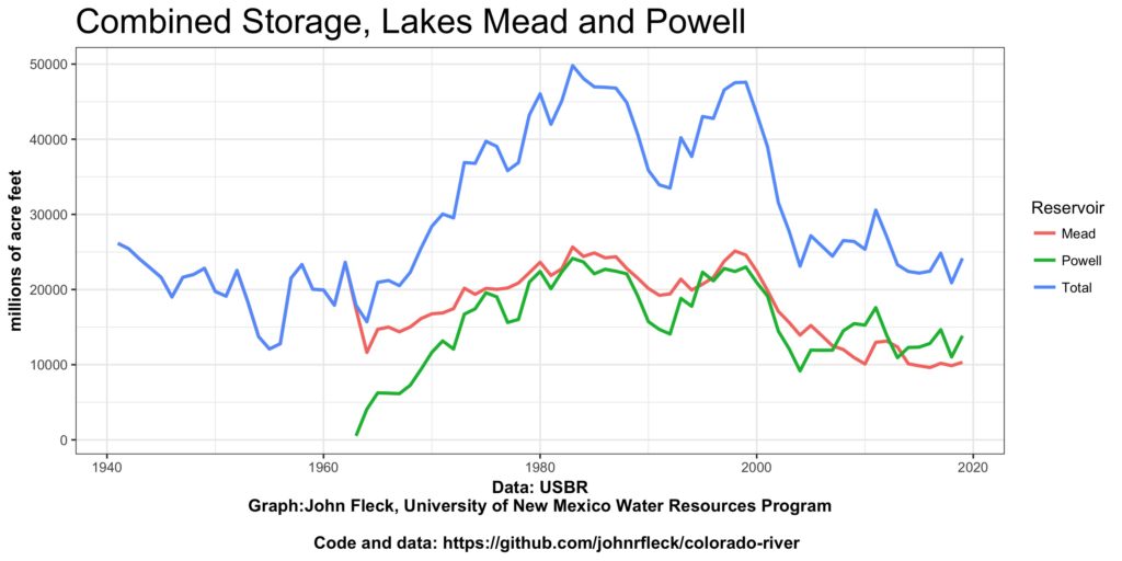
Based on the data available from the Bureau of Reclamation’s Consumptive Uses and Losses Reports, there is little question that, including tributary use and reservoir evaporation, the Lower Basin is using far more than its total 8.5 million acre-feet of apportionment under the 1922 compact. Based on the most recent data available, U.S. total Lower Basin use is at least 10 million acre-feet per year.* A compelling case can now be made that through the implementation of the Upper Basin DCP (with demand management) and Minute 323, Mexico and the Upper Basin are subsidizing this overuse. For the renegotiations, the Lower Basin has two basic approaches: It can continue to insist that the other two parties accept this overuse while its makes incremental progress toward reducing uses under a post-2026 version of their DCP (the incremental approach) or will it ask the Upper Basin and Mexico to accept some long-term level of overuse by offering them something of long-term major value (the Grand Bargain approach).

*To be conservative, we’ve assumed that Lower Basin main stem uses are ~7 million acre-feet per year -reflecting the recent conservation measures, ~1 million acre-feet per year of reservoir evaporation and system losses as water is delivered downstream from Lake Mead, and ~2 million acre-feet per year of tributary water use, reflecting the 2000-2004 period of extremely low water availability.

Can Mexico and the United States agree on a definition of “extraordinary drought” under Article 10 of the 1944 Treaty with Mexico?

The U.S.-Mexico treaty includes language that would reduce deliveries to Mexico under an “extraordinary drought”. But the phrase has never been defined.

Under Minutes 319 and 323, Mexico voluntarily agreed to take shortages, avoiding the treaty question. Statistically, the case that the basin is currently in an extraordinary drought is difficult. The 2005-2017 natural flow at Lee Ferry averaged 13.87 MAF/year, only slightly below the long-term 1931-2017 average of 13.98 million acre-feet per year. The “stress test” period of 1988-2016, 13.19 MAF/year, is slightly wetter than 1953-77, 12.89 MAF/year, (USBR NFDB March 2019).  A second related policy question is that if climate change is slowly reducing the “normal” natural flow at Lee Ferry, how do we even know we’re in an extraordinary drought?  The question is directly related to the Lower Basin’s overuse of its compact entitlement and the disputed question of the Upper Basin’s obligation to Mexico under Article III(c).

As the post-DCP negotiations proceed, will the U. S. basins first negotiate their own deal, then hope Mexico can be brought along as an afterthought? Or can the basin consider an integrated approach that addresses the Lower Basin’s overuse, the disputed Article III(c), and provides more certainty for deliveries to Mexico under the “extraordinary drought” provision?

What comes next

We believe there are several different reasonable outcomes for the post-2026 river:

Incrementalism I

The current package of the 2007 Interim Guidelines (with a few tweaks here and there), the Upper Basin and Lower Basin DCPs, and Minute 323 could be extended for anywhere from 5 to 20 years.  The case for this approach is that it would maintain the recent momentum and give the basin more time to evaluate its effectiveness. Since this approach does not address the LB overuse and Article III(c) issues, it likely favors the Lower Basin at the expense of the Upper Basin and Mexico.

Incrementalism II

River operations could revert to the pre-2007 Long Range Operating Criteria-based operation (an 8.23 MAF minimum objective release plus occasional equalization releases) on a temporary or extended basis. This approach would not be a good outcome for the Lower Basin. The recent 9 million acre-feet per year releases have kept Lake Mead out of shortages. It’s not a great option for the Upper Basin because it continues the 8.23 MAF/year releases, but it may be a step that the Upper Basin should seriously consider if the Lower Basin is unwilling to address the overuse and Article III(c) issues.

The Downside of Incrementalism

The basin disputes, including but not limited to the Lower Basin’s overuse and Article III(c), could escalate to a point where one or more of the states decides to initiate interstate litigation. The conventional wisdom is that both basins would likely be losers in any actual Supreme Court litigation and the big winner could be the power of the secretary of the Interior. Several states, however, may view the threat of litigation as a useful negotiating tactic.

The Grand Bargain

The basin could take a broader approach to develop a more long-term sustainable solution that settles the disputed issues, a “Grand Bargain”. For discussion purposes, we’ve identified two sample grand bargain solutions, one based on a proposal made by Colorado in 2005 at a meeting in Albuquerque (Kevin Wheeler will presenting an analysis in his Boulder presentation) and a second one based on a simple compromise of the Article III(c) dispute.

We refer to our first sample as the Updated Albuquerque bargain. Under this suggestion the Upper Basin would agree to not object to the Lower Basin’s overuse and some form of an Upper Basin use cap. In return the Lower Basin would agree that the Upper Basin had no flow obligations at Lee Ferry (no threat of a compact “call”). Lakes Mead and Powell (and possibly other Upper Basin reservoirs) would be operated to maximize the yield and certainty of supplies for the Lower Basin and Mexico and address environmental issues.  The three Lower Basin states and Mexico would share shortages in a manner similar to the current DCP and Minute 323.

Our second sample bargain is not as far reaching.  We refer to it as the Article III(c) compromise. Under this this solution the basins would agree that the Upper Basin’s long-term obligation to Mexico is 375,000 acre-feet per year for a total ten-year Upper Basin delivery obligation of 78.75 million acre-feet and the new minimum objective release would be 7.785 million acre-feet per year. The Upper Basin would not challenge the Lower Basin overuse. Mexico would accept a proportional reduction in its normal year delivery of 50,000 acre-feet per year, a total of 1.45 million acre-feet per year.  The extraordinary drought provision would be triggered whenever the Upper Basin can’t meet its ten-year obligation (78.75 MAF) without curtailing uses.

The Importance of Process

To be clear, we are not wedded to the specific details discussed in our examples of what a “Grand Bargain” might look like. As we explain in our forthcoming book Science be Dammed, “The process by which such a grand bargain might happen may be every bit as important as the technical details of what it would entail.”

The key here is to recognize that the problem the Colorado River Basin faces goes beyond a simple recognition that water is over-allocated, and uses need to be reduced. We must pursue that process in full recognition that the over-allocation became embedded in basin rules in very specific ways that remain unresolved today, and it is those specifics that must be fixed.

Further reading

For details, including more detailed historical and technical arguments underpinning the discussion above, see the latest draft of a work in progress, “The Upper Basin, Lower Basin, and Mexico: Coexisting on the Post-2026 Colorado River”, one of a series of working papers exploring the policy implications of Science be Dammed, available via SSRN. Links to this and other titles in the working paper series also will be posted on Inkstain’s Colorado River page.

Final Lower Colorado River accounting for 2018

The 2018 Lower Basin accounting report is out, and if you’re interested in understanding what’s happening on the Colorado River, it’s a gold mine. Did you know, for example, that California’s annual Colorado River water use is down 21 percent from its peak in 2002? Or that the Gila Monster Farms on the Arizona side of the river used 4,536 acre feet of water in 2018, up from 4,197 acre feet last year? (I am not making this up, there really is a Gila Monster Farms, read this report and you will be a hit at parties.)

I swear I did not just make up “Gila Monster Farms” to see if you were paying attention.

In all seriousness, there’s some fascinating detail on the river’s operations in the report, a requirement of Article V of the Consolidated Decree of the United States Supreme Court in Arizona v. California,547 U.S. 150 (2006).

It is where you will learn, for example, that

  • Las Vegas is so flush with water that it has now banked 613,596 acre feet of water in aquifers in Arizona and another 330,225 acre feet similarly in California.
  • The states of the Lower Basin have banked 1.742 million acre feet of “intentionally created surplus” water (yes, we call it “ICS”) in Lake Mead since the option to do so was created in 2007.
  • We “bypassed” 122,569 acre feet of water into Mexico via the Welton-Mohawk drain, water too salty to leave in the river, but which is plenty nice to feed the Cienega de Santa Clara wetland.


In the next round of Colorado River negotiations, who will be at the table?

From a fun Q & A I did recently with Tara Lohan at The Revelator:

One of the biggest difficulties is figuring out who gets to participate — who’s in the room when these deals are negotiated. And it’s just not at all clear what the process is going to look like for renegotiating guidelines.

We’ve clearly reached a point where we need to expand the notion of who gets to be a stakeholder. There’s this sort of rigid hierarchy where states get to be at the table and states then get to sometimes be represented by — or inclusive of — their big water users. But who is the person at the table representing air quality and poor people in Imperial Valley? Or who gets to be at the table representing tribes, especially tribes that have a lot of water rights, have a lot of legal and moral entitlement, but don’t have a lot of financial capacity for participation?

I don’t know the answer to this, but this is something I’ve been thinking about a lot. We don’t really know what the process is going to look like.

I said other things as well, including some stuff about what Eric Kuhn and I are working on right now – in the new book and beyond it, thinking about the way our misuse of scientist left huge unresolved issues in the fabric of the Law of the River.

John Wesley Powell at 150: How Can We Tell Better Stories?

A guest post by historian Sara Porterfield:

“May 24, 1869—The good people of Green River City turn out to see us start. We raise our little flag, push the boats from shore, and the swift current carries us down.”

This photograph is of Powell’s 2nd expedition in 1871-2, but he squished both expeditions together in his published journals, so this is somewhat fitting.

Today marks the 150th anniversary of John Wesley Powell’s 1869 expedition down the Green and Colorado rivers from the town of Green River, Wyoming to the confluence of the Colorado and the Virgin on the downstream end of the Grand Canyon. The sesquicentennial of this journey of more than 900 miles into what Powell called “the Great Unknown” has, in the year leading up to today, garnered attention from water wonks, whitewater boaters, scholars, and casual observers, and it will undoubtedly continue to do so over the course of this year—and rightly so. Already, Powell’s journey has spawned op-eds, books, and replica journeys (albeit, undertaken with modern rubber boats rather than the ill-suited wooden boats Powell commissioned), all of which is unsurprising and even fitting given the larger-than-life status Powell has come to inhabit in the minds of conservationists, Western water stakeholders, and those of us who occasionally like to run the rapids of the Colorado River Basin.

Anniversaries—particularly one as significant as 150 years—provide a ready-made opportunity to celebrate and remember individuals, their actions, and their legacies. But in commemorating Powell, his expedition, and his contrarian vision of Western settlement that grew out of his firsthand experience in the Colorado Basin, we’ve missed an opportunity to reflect critically on the American response to and memory of Powell over the past century and a half. Rather than unquestioningly celebrating Powell and his legacy, this year gives us the chance to think about a couple of points:

  • First, how are we telling Powell’s story now, and how have we told it in the past? Is it, and has it been, accurate and useful?
  • Second, whose stories have we excluded, ignored, and forgotten about in the focus on Powell?

When we start to answer these questions, the sesquicentennial of Powell’s journey becomes an opportunity to explore new and different ways of thinking about the Colorado River and Western water.

I will be the last person to say that Powell wasn’t a deeply impressive person who provides us twenty-first-century dwellers ample fodder for celebration of his legacy. He planned, funded, staffed, and executed (on a shoestring budget) a months-long expedition into a region unknown to Euro-Americans. In perhaps his most oft-quoted passage, Powell captured this sense of looking past the edge of the known world: “We have an unknown distance yet to run, an unknown river to explore. What falls there are, we know not; what rocks beset the channel, we know not; what walls rise over the river, we know not. Ah, well! We may conjecture many things.” To make this feat even more impressive, Powell had only one arm. He was a disabled military veteran, having lost his right arm at the elbow after a Confederate minié ball shattered his wrist at the Battle of Shiloh.

Powell’s legacy may have been fairly well assured had he returned to teaching college courses on natural history upon his return from the Colorado, but he did not rest on his laurels. Instead, he became a bureaucrat in the nation’s capital, where he pushed back against the boosterism of his day that promoted the West as a limitless and idyllic Eden where “rain follows the plow” and settlers would find easy success. Based on his experience in the “Arid Region,” Powell advocated caution instead of a headlong rush to populate the West, arguing that the region couldn’t sustain the population boosters advertised because of its climate. This debate produced what is probably the single most recognizable image in Western water history—Powell’s map of Western states drawn by watershed—and cemented his legacy as a progressive thinker who understood the concept of environmental limits.


Yes, these are reasons to celebrate Powell. But remembering him in this way has created its own set of problems.

First is the celebration of Powell’s journey into the “unknown.” Unknown, one might ask, to whom? Certainly the Indigenous people of the region knew the river and its environs intimately—it was unknown only from a Euro-American perspective.

Second, focusing on Powell also creates an image of the nineteenth century Colorado River from the viewpoint of a white, male, colonial character, a perspective that has persisted throughout the twentieth century and is only beginning to change (haltingly) in the twenty-first.

Third, the mythic proportions Powell’s battle against the boosters has taken on makes it the origin story for a history of Western water defined by conflict—the un-usefulness of which I don’t have to explain if you’re reading John Fleck’s blog. Finally, because Powell provides such an epic and charismatic figure, his viewpoints and actions are too often misremembered, distorted, and molded to fit the present day. See my review of a recent book about Powell for further discussion of the problems of presentism and inaccuracy.

So what have we missed in focusing on Powell? He is, it must be said, yet another dead white guy who’s been lionized in the intervening 150 years. Whose stories have we ignored in retelling his over and over? At the top of my list are the stories of the Indigenous peoples of the Basin. Yes, Powell was also an ethnographer and worked to record tribal customs and language—but only because he thought it inevitable that they would die out in the face of Anglo advancement into the West. What would an Indigenous history of the Basin look like? In this vein, what about a women’s history of the Basin, or a history of race and water? Westerners, those of us involved in water, in particular, are storytellers. Let’s tell better, more accurate, and more helpful stories that can help welcome a more diverse range of stakeholders to the table (while acknowledging they’ve been present the whole time), and that can encourage a larger portion of the population to see themselves in the history of how the Colorado came to be what it is today.

To this end, my colleague Dr. Adrianne Kroepsch, at the Colorado School of Mines, and I have started a Google Doc to build a better, more diverse repository of sources for Colorado River Basin history. Please feel free to browse, add to, and share the document, available publicly at this link: https://docs.google.com/spreadsheets/d/1P2Bcg-xzNi8GgmDuSdIZfPGM9CACJSyLGTEE7N7WKIs/edit?usp=sharing

What the Colorado River Drought Contingency Plan means in practice

Correction appended, I was off by 5kaf on the Nevada numbers, also fixed a badly garbled sentence, thanks to the alert reader who brought this to my attention

With the backdrop of Hoover Dam, an assembly of Colorado River dignitaries signed the Drought Contingency plan yesterday afternoon.


Now that we have a DCP, what does this mean in practice?

According to the most recent Bureau of Reclamation 24-month study, Lake Mead is projected to end 2019 at elevation ~1,085 feet above sea level. Prior to the DCP, Lower Basin water users (Mexico, Arizona, Nevada, California) got a full allocation of water as long as Lake Mead’s elevation was above 1,075. Under the DCP, a new shortage tier has been added between elevations 1,090 and 1,075. The result is that, for the first time in the history of Colorado River management, there will now be mandatory water use reductions on the Colorado River.

What does this mean in practice? I ran down a quick summary this morning of the relevant data, comparing recent use with the cuts mandated under the DCP. It shows that, at this first tier of shortage, permitted use is mandatory reductions are less than the voluntary cuts water users have been making since 2015:

in millions of acre feet Arizona Nevada California total
2015-2019 average, without DCP 2.578 0.242 4.234 7.054
2020 permitted, with DCP 2.608 0.292 4.4 7.3

In other words, all of the states are already using less water than contemplated in this first tier of DCP reductions.

The details, by state:

Arizona

Arizona’s full allocation is 2.8 million acre feet of water per year. In this new first year of shortage, Arizona will only be allowed to take 2.608 million acre feet of water, a 192,000 foot reduction.

This year, without any DCP, Arizona plans to voluntarily take larger reductions. The current forecast puts Arizona’s 2019 draw on the river at 2.515 million acre feet. Last year, Arizona took 2.639 million acre feet, according to the Bureau of Reclamation’s preliminary year-end accounting.

Here’s a summary of recent years:

Arizona Without DCP:

  • 2015: 2.601 maf
  • 2016: 2.613 maf
  • 2017: 2.510 maf
  • 2018: 2.640 maf
  • 2019: 2.515 maf

Arizona with DCP:

  • 2020: 2.608 maf

Nevada

Nevada’s full allocation is 300,000 acre feet of water per year. In this new first tier of shortage, Nevada will only be allowed to take 287,000 acre feet of water.

This year, without any DCP, Nevada plans to voluntarily take larger reductions. The current forecast puts Nevada’s 2019 draw on the river at 263,000 acre feet, but because of the way the forecasting is done, that will almost certainly go down. Last year, Nevada took 244,000 acre feet of water.

Nevada without DCP:

  • 2015: 220 kaf
  • 2016: 238 kaf
  • 2017: 243 kaf
  • 2018: 244 kaf
  • 2019: 263 kaf (but likely to drop)

Nevada with DCP:

  • 2020: 292 kaf

California

California’s full allocation is 4.4 million acre feet of water per year. California takes no cuts in this first tier of shortage

This year, California plans to take significant voluntary reductions. The current forecast puts California’s 2019 draw on the river at 4.064 million acre feet. Last year, California took 4.253 million acre feet of water.

California without DCP:

  • 2015: 4.494 maf
  • 2016: 4.381 maf
  • 2017: 4.026 maf
  • 2018: 4.253 maf
  • 2019: 4.064 maf

California with DCP:

  • 2020: 4.4 maf