The Bicycle of Theseus and the Paradox of Identity

Screenshot, Smart, Brian. "How to reidentify the ship of Theseus." Analysis 32.5 (1972): 145-148.

Smart, Brian. “How to reidentify the ship of Theseus.” Analysis 32.5 (1972): 145-148.

In the fall of 2003, I bought a new bicycle.

I wore spandex and those practical (albeit a bit silly) cyclist’s shirts with pockets on the back for snacks.

the bike of Theseus

In the years that followed, I rode that bicycle a great deal. While my data are imprecise (my crazy data nerd spreadsheet has all the miles, but does not distinguish which of my bicycles I was riding on any given day), I can comfortably say I rode that bike the equivalent of more than once around the circumference of the earth.

I love(d?) that bike.

I am older now, enough so that the sort of zooming I did then – “light and quick” is how I described it – is of less importance. A change was appropriate. I settled on a new steel frame from All-City, and ace mechanic Brett at Two Wheel Drive took all the kit – wheels, shifters, handlebars, etc. – from the old bike and put them on the new bike.

Or was it a new bike?

“Oh, like the ship of Theseus?” said Reed.

Me: “Umm, yeah, I guess?” (Further research was needed.)

The story is that Theseus, back in the day, did awesome stuff, really heroic (slaying of monsters and the like), in a ship. Anchored in Athens harbor post-monster slaying as a sort of monument, it began to decay, as ships do. The Athenians, in a quest to preserve it, replaced the bits as they decayed, until over time none of the original ship remained.

So was it still the ship of Theseus?

Since I bought the bike you see above back in 2003, I’ve replaced bits and pieces. Two years ago, with a new frame, it had reasonable “new bike” credentials. But the wheels I ride today are the same ones I rode in 2003, as is the seat post.

A couple of weeks ago, Brett replaced the derailleurs for me – I’ve now got super low old man climbing gears – and today I finally gave in and bought a new seat bag for my goathead response kit.


the bike of Theseus

Worth noting: the cactus in the background. Also the same?

Colorado River water reduction rules: not quite voluntary, not quite mandatory – “vandatory”!

After Friday’s blog post and some intemperate tweeting about whether the Colorado River Drought Contingency plan cuts about to go into effect were voluntary or mandatory, a friend involved in the negotiations explained that they actually came up with a word for this: “vandatory”.

The idea was that everything they all agreed to in DCP was voluntary to enter into. But once signed, fulfilling its terms then becomes mandatory (i.e. contractually binding and now mandated by congressional directive to the Secretary).

I’m gonna get my “CLOSE IS NOT DONE” tattoo lasered off and replaced with one that says “VANDATORY”.

A decent (not great, but decent) water year on the Colorado was not enough to stave off mandatory cuts

a screenshot of the actual historic text message

Walking across the University of New Mexico campus yesterday afternoon on my way to orientation for our incoming UNM Water Resources Program students, at precisely 3:10 pm MDT, a friend sent me a historic text message: “1089.4”.

Translated from the native language of the Colorado River Water Nerd, “1089.4” means “The surface of Lake Mead in the Bureau of Reclamation’s August 24-month study is forecast to end the year at less than 1090 feet above sea level, triggering the first mandatory cuts in the long history of the Law of the Colorado River.”

Below we will discuss quibbles with two of the words in that sentence: “first” and “mandatory”. But in my struggle to distill the complex into overly simple messaging that I can bang home in the style of the newspaper writer I once was – yes, this is historic.

This almost didn’t happen. When the DCP was signed in May, the Bureau of Reclamation was forecasting that Mead would end the year at elevation 1084.9, more than five feet below the trigger for mandatory cutbacks. Yesterday’s forecast was nearly five feet higher, just barely below the cutback trigger. But we’ve had a really wet year, haven’t we?

But 2019’s been really, really wet, right?

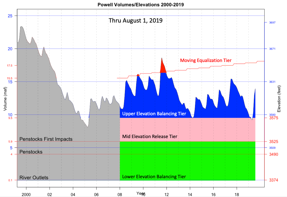
Not exactly. Some really helpful back-and-forths by email and telephone the last few days with Colorado State’s Brad Udall and my coauthor Eric Kuhn (buy our book, soon) has convinced me that a lot of the rhetoric about a giant snowpack and booming runoff, including some of my own, has not held up terribly well. Here’s a super helpful graph Brad made showing elevations in Lake Powell:

Elevation of Lake Powell, courtesy of Brad Udall

Yes, Powell is up this year, but it’s just a 22 percent above the long term average, nothing like 2011 and not all that much higher than 2017. I guess it seemed to me like a lot of water because the 21st century has been so dry.

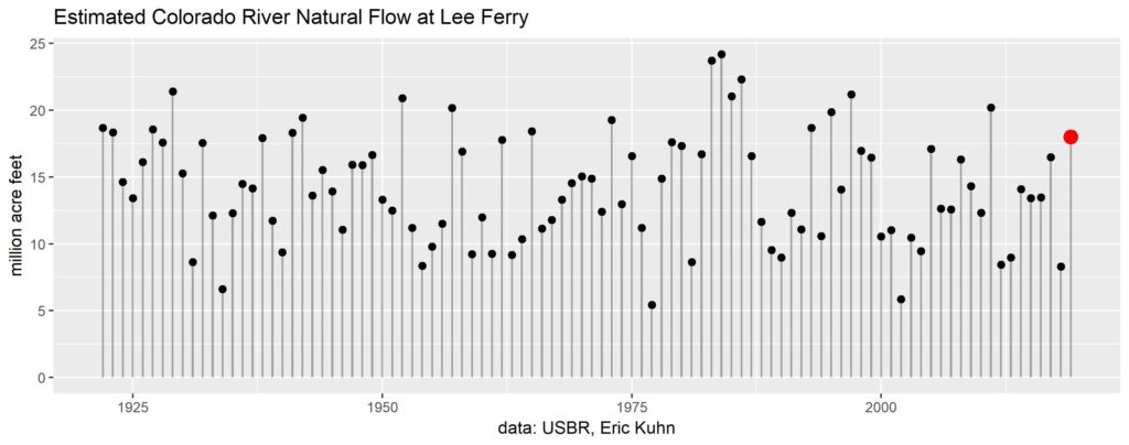
Long term Colorado River flow

The main reason Mead is ending the year so much higher than the May forecast is a) a reduction in Lower Basin use as compared to the May forecast, and b) an increase in tributary inflow below Glen Canyon Dam. That combination came within half a foot of Lake Mead elevation of saving me the need to write this tangled blog post.

I prefer to call the DCP cuts “mandatory”

There’s been a weird linguistic thing going on in the news coverage of 1089.4, with some writers characterizing the coming reductions of water use as “voluntary”. It’s easy to get sidetracked in a twisted binary linguistic argument about whether the cuts are “mandatory” or “voluntary”, which is best sidestepped by being explicit about the actual characteristics of the thing that is happening here.

In recent years, including this one, the states of the Lower Colorado River Basin have been doing a bangup job of using less water. No one is forcing them to, so the term “voluntary” seems to pretty clearly apply. Importantly, this means that they are not required to do this, and there are no guarantees that in coming years they would.

In May, all the states signed an agreement explicitly laying out rules that would cut their water use when Lake Mead is below 1090.  Lake Mead will be below 1090. So the rules now require Arizona, Nevada, and Mexico to reduce their water use. Rather than hope for voluntary reductions in 2020, we can all count on the cuts because the rules require them. This carries an important characteristic of “mandatoriness” to me.

Did the states agree to the rules? Yes. Does that make them voluntary? Sure, whatever, I guess this has some characteristic of voluntariness too. But by this linguistic argument, we’d have to call Interior Secretary Gale Norton slashing California’s deliveries to L.A. through the Colorado River Aqueduct Jan. 1, 2003 “voluntary” because California had agreed in 1928 to the rules Norton was invoking. All the mandatory cuts we can see out there in the future of the Law of the River – an Upper Basin Compact call being the most obvious – would under this linguistic interpretation count as “voluntary” because they grow out of enforcement of rules to which the states had previously agreed.

It is the case that the states did come together to agree to these cuts, and there is voluntariness about that process that matters. Still, the fact that we now have enforceable rules that create requirements seems the salient point here, whatever words we use to describe them.

But is this really the first time we’ve had mandatory cuts?

So I guess now that I think it through, that “first time” thing was a bunch of crap designed to sell newspapers. As I acknowledge above, Gale Norton forced California to reduce its Colorado River water use from more than 5 million acre feet to 4.4 million acre feet back in 2003.

In thinking it through to write this post (folks this is why I blog) I’ve clarified my own thinking from the bombastic “OF COURSE IT’S MANDATORY” thinking of intemperate afternoon tweets. The voluntariness of what is happening now, as compared to what happened with California in 2003, seems relevant.

Maybe we could call it the first time the states have voluntarily agreed to mandatory cuts?

* “Ill-named” because this isn’t about drought. This is about us using too much water.

Water is no one thing

fountain at the University of New Mexico

the cool of a fountain

Headed out across campus in a quest for coffee this morning, I had occasion to stop and rest at the little courtyard fountain on the south side of the University of New Mexico’s Zimmerman library.

In a neat thesis a couple of years ago, UNM geographer Susanna Diller identified three core values of fountains:

  • a proxy for nature
  • an aesthetic landscape feature
  • a site of relaxation

I’ve been thinking about fountains as I prepare for the arrival next week of a new cohort of UNM Water Resources Program students. As a communicator, I think a lot about “framing” – the importance of the first thing you say as you launch a communication process, the way it sets up all that follows.

The UNM Duck Pond as a Framing Device

The courtyard fountain is one of two on this part of campus, which sports a lovely patch of lawn and a duck pond. (Or maybe three fountains? The duck pond has two fountainy things spurting water.) We pump groundwater from an aquifer 400-plus feet below us to feed these fountains and water these lawns, and the question of their value – the value of water in this particular use – is the starting point for a lecture I’ll be giving in a couple of weeks.

I happen to love the fountains. This is, to me, a valuable use of water. Lots of people seem to agree. When I was writing my last book, I’d often spend weekend afternoons in the office writing, I’d always go for walks around the duck pond, and I’d always see people there enjoying them. These were people who had sought out the campus on a weekend to hang out by the fountains.

But I also understand that some people do not share my views – “an economic drain and an unethical space”, as one person argued.

That goes to the heart of the question the entering UNM Water Resources Program cohort of 2019 are about to tackle: given that water is scarce, how are we to balance the competing, often conflicting, values we all hold about water?

Alfalfa in the desert? Lawns?

I’m working out some schtick for the first lecture that I’d like to try out on y’all, if you don’t mind. It involves the duck pond.

As I said before, I find the duck pond to be of tremendous value. And it is a public good – I don’t have to pay a dime to enjoy it, and my use of the duck pond does not preclude others from using it as well. The duck pond is, to use the terminology we’ll be teaching this fall, “nonexcludable” (no one can be prevented from enjoying the pond) and “nonrivalrous” (the enjoyment of one pond user does not prevent its enjoyment by others). Water as a public good. (I hope you’re taking notes, WR571 students.)

But the value I find in that water is of a very particular sort.

On the tail end of a hot Saturday bike ride, I might find myself riding through campus on my way home (true this, I nearly always cut through campus on my bike rides, because duck pond). Should my water bottles be empty (true this, a common state of affairs at the tail end of a hot bike ride) I would place a great deal of value on water I could drink.

You’ve seen the duck pond, right? Ick! And the buildings are generally closed summer weekends, so refilling at a drinking fountain is not an option.* At that moment, I’m willing to shell out a buck fifty for bottled water at the Kwik-E-Mart. True this. I often refill this way when I’m out riding and there’s no public drinking fountains to be had.

So the value of water here is no one thing. It’s almost like the “duck pond public space enjoyment” and the “it’s hot and I’m really thirsty” are describing a relationship with two entirely separate things. We call them both “water”, but as we move through a complex discourse about competing values for “water”, we need ways of disentangling what we mean by “water” and its value.

We have:

  • water inside our houses (drinking, cooking, cleaning and the like)
  • water outside our houses (watering our yards)
  • water to grow crops
  • water left in the river for the river’s own sake

Historian Christopher Hamlin has written (sorry, not sure where there’s an ungated copy) about the 19th century linguistic transition between “waters” and “water” – between thinking of water as many things and an “essentialist view” of water as one thing.

This is the course we’re setting out on as a new group of Water Resources Program students arrive – to tease apart the differences and begin thinking about how water managers cope. It’s an exciting time.

* At this point, for Prof. Fleck’s clever lecture trick to work, he must ignore the fact that he has a key to the building where his office is located, adjacent to the duck pond. The drinking fountain at the end of the west hallway is definitely excludable as to the general populace, but not to a faculty member with a key. (Extra credit – there’s also a bathroom at that end of the hall. Discuss.)

The repartimiento – a deep history of sharing water

Preparing for the fall class I co-teach, I was sitting out by the shady fountain in the old Zimmerman Library courtyard this morning, when I had occasion to spill carne adovada from my breakfast burrito on my copy of Jose Rivera’s book chapter on “The historical role of acequias and agriculture“. (Technically it’s my co-instructor Bob Berrens’ copy of the book. The page is still readable so I’m hoping Bob won’t mind.)

There are nested metaphors here – Bob shares the book, about New Mexico’s deep history of sharing water, and I spill one of New Mexico’s treasured foods, a rich slow-cooked pork red chile yum, upon it.* The only thing better would have been if I’d actually been sharing a burrito with Bob too, but no way, I was super hungry, sorry Bob.

https://cdn.loc.gov/service/pnp/habshaer/nm/nm0300/nm0325/sheet/00003v.jpg

Modern engineering attempts to describe the acequia madre in La Bajada, New Mexico.

On the page right after the carne adovada stain, Jose (who used to lecture every year to our fall class before he retired) talks about the repartimiento, or dividing of waters, at the heart of New Mexico acequia culture. It is a deep institution brought from Northern Africa by way of Spain by European colonists in the 1500s.

In his book Enduring Acequias, the late Juan Estevan Arellano explained:

In times when there is plenty of water, nobody really cares about measuring it or about how much water an acequia uses…. But in times drought, like in the 1950s and in 2002, acequias have had to fall back on the ancient tradition of adhering to the repartimiento de agua, the sharing of water, based on la palabra del hombre (the oral word of man) and equality. When repartimiento is in force, the comisionados and mayordomos figure how many surcos are in the river at that time and then divide the number of surcos among the different acequias based on the number of peones (which should correspond to acreage) each acequia has.

It’s worked for a long time, but the overlay of modern water law institutions spanning boundaries beyond the communities along a single river reach are stressing the system. “How long the repartimiento system will last,” Arellano wrote in 2014, “no on knows.” One of the points Elinor Ostrom, whose thinking guides our fall class, makes is the importance to common pool resource management of what she calls “cross-scale linkages” – the interaction of a system with those around it. Arellano’s descriptions of acequias’ difficulties at the boundaries is a great example – with the overlay of New Mexico’s water law system, and a bunch of newcomers “who don’t want to follow the custom and tradition”.

The linkages to be managed cross both space and time.

For completeness sake, there is a less-talked-about parallel to “repartimiento” called “convite” – a tradition of sharing of food. “That disappeared with the coming of supermarkets,” Arellano wrote. So no, Bob, you can’t have any of my delicious carne adovada breakfast burrito.

* If you wanna go full New Mexico with this, full bridging-our-past-with-our-future, the breakfast burrito came from Twisters, which is “Los Pollos Hermanos” in Breaking Bad. Sometimes this stuff writes itself, and I’m just sitting in the back hoping it doesn’t crash.

Floods on the Colorado: If It Has Happened in the Past, It Can Happen

By Eric Kuhn

The University of Arizona’s Vic Baker on paleofloods of the Colorado River. Photo by Eric Kuhn

Last week I had the pleasure of exploring the banks the Colorado River near Moab, Utah with two of our most accomplished river scientists, Jack Schmidt (Utah State) and Vic Baker (U of Arizona), and hear a presentation by Dr. Baker on the science of studying past floods on the Colorado River system.  When a flood occurs, the river leaves evidence of the flood by depositing materials that are carried by the river high on the banks of the river or in caves adjacent to the river. His basic message is “if it has happened in the past, it can happen,” therefore, if we can use the evidence nature has provided to estimate the peak discharge of past floods, we can use that knowledge to be better prepared for future floods.

With the recent focus by the basin’s water management agencies on drought contingency plans, flooding has been given little attention.  In fact, there are now only very few of us around who were actively involved in river operations during the last major flooding event on the river; the high flows of 1983 and ’84.  By now the story of 1983 is well known. The large runoff caused by a wet winter and spring combined with higher than normal carry-over storage in Lake Powell caught the Bureau of Reclamation by surprise.  The resulting inflow quickly filled the reservoir and far exceeded the capacity of Glen Canyon Dam’s power plants and outlet tubes (44,000 cfs) requiring a large amount of water to be released through the emergency spillways.  Cavitating flow through the spillways caused considerable damage carving out a small building-sized hole in soft sandstone that surrounds the dam. Further damage was avoided by the installation of 8’ plywood panels on the top of the dam (they were quickly replaced by steel panels).  In theory, the emergency spillways have now been repaired and redesigned to reduce cavitation (and successfully tested with a short duration high flow), but clearly the reoccurrence of a large uncontrolled spill at a dam anchored in relatively soft sandstone (Glen Canyon) is an event we want to avoid.

The remarkable aspect of the 1983 and ’84 high flows is just how unremarkable and modest the peak flow levels were. The inflow to Lake Powell peaked at about 116,000 cfs in ’83 and 125,000 cfs in ’84.  Before Glen Canyon Dam the largest peak flow we’ve experienced and documented at Lee’s Ferry is about 250,000 cfs in 1884, twice the peak flow of 1984. We know 1884 was a very big year based on newspaper reports and the diaries of settlers, but the flow estimate is somewhat crude. It was made based on the memory of one of the ferry employees whose cat became stranded in a tree by the flood and had to be rescued. Based on Dr. Baker’s science, even this 250,000 cfs flow at Lee’s Ferry is far from the largest flow that has happened in the past 2000 years.  Based the field work of Baker and his students, evidence of flood flows on the Colorado River just upstream of Moab, Utah and the nearby Green River point to a flow as high as 300,000 cfs (each). The estimated past peak flow at Lee’s Ferry is about 500,000 cfs, four timed the 1984 peak!

But wait you say, don’t we believe that climate change is reducing, not increasing, the natural flow at Lee’s Ferry? The answer is yes, the best available science suggests that the long-term average annual natural flow at Lee’s Ferry is likely declining.  That does not mean, however, that future large flood flows will be less. In fact, because a warmer atmosphere can hold more moisture, science points to the possibility of much larger future peak flows. I can envision an above average runoff year (like 2011 or 2019) that makes a reasonable dent in the filling of Lake Powell (enough that because of our concern with drought, the Upper Basin would want to keep every drop of it in storage) followed by a super-wet year. Perhaps a year where the track of a series of warm and very moist atmospheric rivers comes in off the Pacific through Southern California with the bullseye on the Colorado and Utah Rockies for an extended period of time. The resulting runoff peaks with an inflow to Lake Powell of over 400,000 cfs and a total volume of near 50 million acre-feet (the climate models suggest it’s possible).  The potential impacts of such an event could be very serious. Even if Lake Powell was only half full, such flows would quickly fill the available vacant space, then possibly exceed the capacity of Glen Canyon Dam’s emergency spillways and over-top the dam. In theory, the dam might survive an over-topping event, but remember how a little imperfection in the service spillway at Oroville Dam resulted in huge damage to the structure (because of the immense erosive power of high velocity water).

Ultimately the flood waters would work their way down through the Grand Canyon, scouring the canyon and causing major environmental damage, into Lake Mead and the Lower Basin main stem reservoirs. The highest flows would be dampened by the lower river facilities, but still high enough to potentially cause major damage to communities along the river From the Mojave-Parker strip to Mexico. This stretch has seen considerable growth, but no high flows since the mid-1980s.  In the worst-case scenario, the flooding impacts might cause a dam failure. The results of which would be catastrophic. I’m not predicting such an event will happen any time soon. I’m only suggesting that with the dominant focus on managing the impacts of aridification, we would also be derelict for not considering and being prepared for future large high-flow events. Given the uncertainties of climate change, the basin’s water agencies would be wise to fund additional studies on the high-flow side of hydrograph while they continue their plans to live with reduced average flows.


The Salton Sea: “treat it as a real place that impacts real people’s lives”

Shorline left by a shrinking Salton Sea.

Salton Sea, June 2019

Imperial Valley resident (and Imperial Irrigation District board member) Jim Hanks:

The Salton Sea is a real place to me and I have always seen it as a lake, because that’s what it is. I also see it as hydrologically, geographically and morally connected to the Colorado River, and I appreciate the effort to place the Salton Sea issue in the context of a broader discussion within the river community, which is where I think it belongs.

“Hydrologically, geographically and morally connected” – that’s a nice bit of business there.

The biggest year since 1995 on New Mexico’s Middle Rio Grande

Near the peak – the Rio Grande near San Felipe, May 2019

Thanks to continued high flows, this is now the wettest year on New Mexico’s Middle Rio Grande since 1995.

My measurement point is the San Felipe gauge on the Rio Grande in north-central New Mexico. The measure is total flow to date this year, compared to total flows at this point in all previous years going back to 1927.

I use the San Felipe gauge for two reasons. First, it is one of the older gauges on the river, and the oldest in the reach that flows through the greater Albuquerque area. Second, it is above several significant diversions – one agricultural at Angostura, the other municipal at Alameda. Thus it more accurately captures flow into the valley before we start skimming off water to do stuff with.

San Felipe gauge

At the Central Avenue bridge, another important measurement point, we’ve had the largest year-to-date flow since 2005. With continued high flows, we may yet surpass 2005 at Central as well.