Conjure Water is a mage spell that provides the caster with mana-replenishing drinks. There is no limit to the amount of water a mage may conjure or carry.
Fetch us some mages. (source)

Conjure Water is a mage spell that provides the caster with mana-replenishing drinks. There is no limit to the amount of water a mage may conjure or carry.
Fetch us some mages. (source)
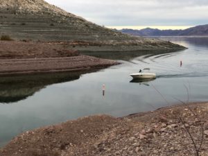
Up close with Lake Mead’s bathtub ring
LAS VEGAS – With Commissioner of Reclamation Brenda Burman’s ultimatum to the Colorado River Basin States at the just-completed Colorado River Water Users Association meeting in Las Vegas, it seems we’re going to get a Drought Contingency Plan, or something very much like it, in 2019.
This could be very messy, but it suggests that either voluntarily (through interstate agreement) or imposed by the feds, we’ll have new shortage guidelines in place by 2020 to slow the decline of Lake Mead. While the messiness will occupy a lot of our attention over the next year, we shouldn’t lose site sight of what comes next. DCP is a bridge, providing some stability while we launch the round of discussions needed to shore up the Law of the River.
Importantly, however, the messiness of the DCP discussions have provided some useful new clarity about what will be needed to solve the longer term problems, and also are building some of the tools we’ll need to solve them.
In broad terms, I see two big long term problems.
The malfeasance of the Law of the River’s framers in ignoring science (the subject of the new book Eric Kuhn and I are writing) left us with a web of water allocation rules based on a fictionally large supply of water. Part of the malfeasance was a failure to build tools to help manage downside risk, to cope with reallocation if and when the supply wasn’t that large.
Now, whether through ignorance or, again, malfeasance, we now have communities that have come to expect that fictionally large supply, and few rules to determine who gets less, and how much.
So yeah, climate change means less water. That makes solving Problem One harder.
The basin leadership came at us with a crisp talking point that I heard over and over again at CRWUA: “Close isn’t done.” Yes we’re close to a DCP, but we’ve been that way for a while. The longer we wait without getting to “done”, the bigger the risk gets.
Burman signaled that the federal government’s patience has run out. She gave the states of the Colorado River Basin until Jan. 31 to sign off on the DCP. If the deal’s not done, Burman said, the federal government will begin steps to take action of its own. “We will act if needed to protect this basin,” Burman said during an extraordinary Thursday morning address to a packed Caesar’s Palace ballroom.
This raises the question of “the secretary’s discretion” – under what conditions can the U.S. Secretary of Interior step in and reduce deliveries from Lake Mead under its Law of the River authorities? It is a huge unresolved legal question, and we now have the prospect of testing its boundaries in 2019.
Five of the seven Colorado River Basin states have essentially committed their states to the DCP, California is largely there save some last-minute hesitation regarding the perennial and largely unsettled question of mitigating impacts on the Salton Sea. Once Arizona’s ready, there’s little question California will fall in line. But Arizona? There was an unusually large contingent of Arizonans at CRWUA. I hope they noticed us all tapping our feet impatiently, arms folded, glaring at them.
Meanwhile the Metropolitan Water District of Southern California has increased the pressure with an ultimatum of its own. Absent a DCP, Met is at risk under the current rules of having its banked water stranded in Lake Mead. DCP would relax those restrictions, but without a DCP, Met has made clear it has no choice but begin taking that water out beginning in January. (Daniel Rothberg explains all this here.) This means Lake Mead drops faster, increasing everyone’s risk, but especially Arizona’s. (Tapping foot, glaring, arms crossed, at Arizona.)
If there’s no DCP come Jan. 31, Reclamation will begin a process aimed at coming up by summer with rules needed to slow the decline of Lake Mead. Given that the basic framework of DCP has general agreement, it’s easy to imagine that the Reclamation plan would not be that different:
In the next few months, the chaos resulting from the lack of DCP and the hustle to either finish it or cobble together a Reclamation-imposed alternative will seem all-consuming.
Given the number of brain cells being burned to exhaustion by the DCP process, one argument over the last year among basin insiders is the suggestion that we should just give up, let the current rules run while we begin the next step – renegotiation of what are called the “Interim Guidelines”.
Negotiated from 2005-2007, the Interim Guidelines are the current rule set for managing Lake Mead and Lake Powell. They govern how much water is released from Powell, and when. They govern the depth of cuts taken by Arizona and Nevada as Lake Mead drops. That famous “Arizona faces a COLORADO RIVER SHORTAGE when Mead hits elevation 1,075” rule? That’s the Interim Guidelines.
The guidelines expire in 2026, and also include a provision requiring renegotiation to begin in 2020. The fear is that those negotiations would be exponentially harder if you had no DCP and a plummeting Lake Mead.
Speaking to the Arizona Republic’s Ian James, Arizona’s Sharon Megdal put it this way:
“We’ve got to get this done so we’re prepared in 2020 to start renegotiating the shortage-sharing guidelines, and that’s really the future — a future of less water use,” Megdal said.
“What’s happening in the environment is happening in the environment, and we have to adapt to that,” Megdal said. “We’ve got to plan for less water.”
There are a bunch of thorny unresolved issues in the current rule set that will have to be sorted – issues that, because of the overallocation of the river, would be hard no matter what, but that are made worse by climate change.
On all these points and many more unsettled issues, everyone has clever lawyers with an interpretation that favors their interests. But clever lawyering won’t conjure water, which is the key to what Megdal is saying. We’ve got to plan for less water. DCP recognizes that, but the difficulties in coming to final agreement on the DCP suggests not all the basin’s water users grasp the new reality.
That, I think, is DCP’s most important lesson.
Mead, Elwood. (1903). Irrigation Institutions.
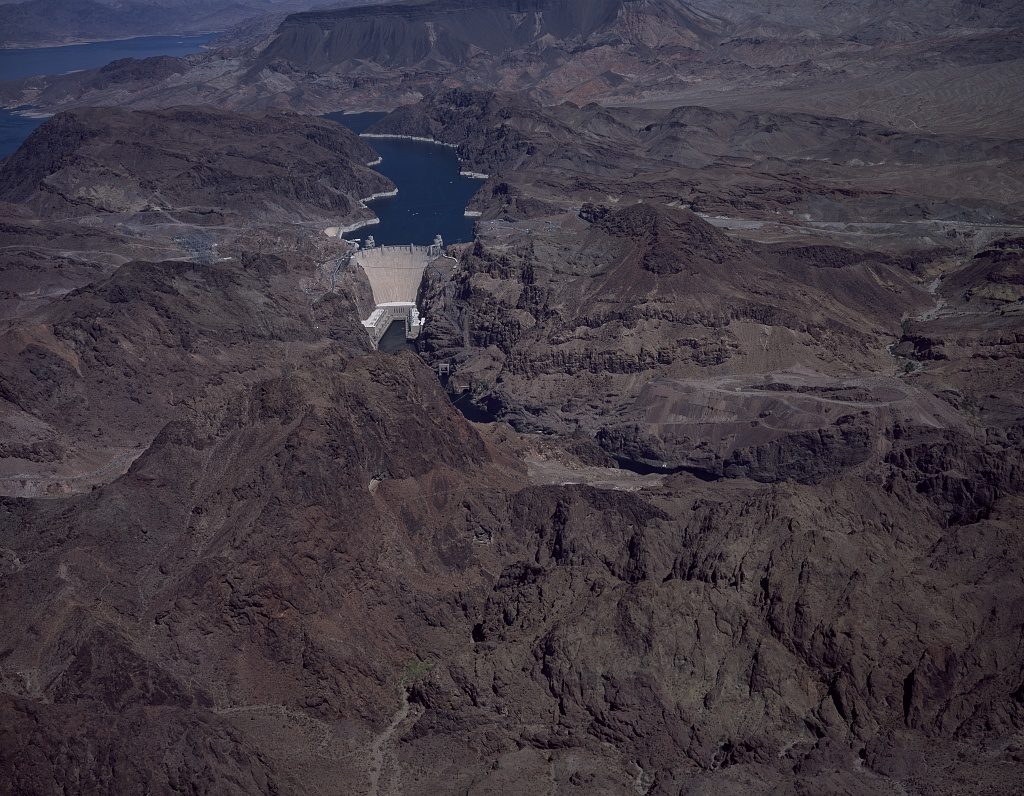
Aerial view of Hoover Dam, near Boulder City, Nevada. By Carol Highsmith
Looking for art for the new book, I ran across the above picture from the amazing Library of Congress collection of Carol Highsmith’s work. Hoover Dam as cultural icon is big and muscular, which is by design and also a function of the fact that it’s hard to get back and see the dam in context. Most pictures are taken from up close, and from that vantage point it really does look big and muscular.
But if you get back a bit to see its context, it looks tiny, and fragile. Which is a nice metaphor.
New data from the U.S. Bureau of Reclamation shows that total 2017 water use in the basin – 14.07 million acre feet – was the lowest since 1984.
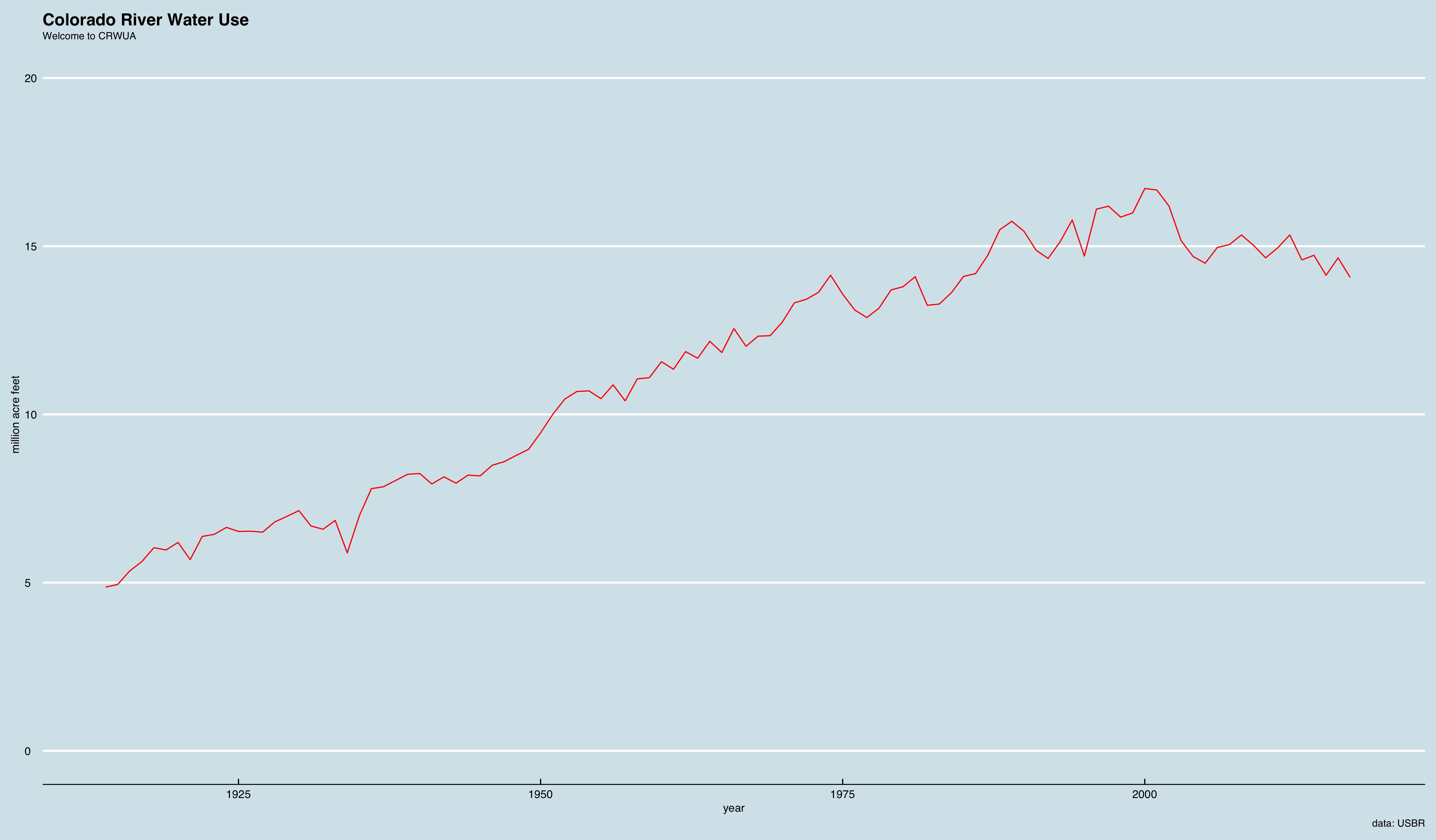
The total here includes estimated consumptive use in the Upper Basin, Lower Basin, Mexico, plus reservoir evaporation and estimated evapotranspiration by native vegetation.
A letter this afternoon from Arizona Department of Water Resources Director Tom Buschatzke to Central Arizona Project board members, also circulated to Arizona’s Drought Contingency Plan Steering Committee, suggests another hangup in Arizona’s efforts to agree on a plan to reduce its Colorado River water use. It involves the distinction between using water from on-river water users versus contributions from users in central Arizona, in regard to a proposal from CAP board member Karen Cesare:
Full letter is here.
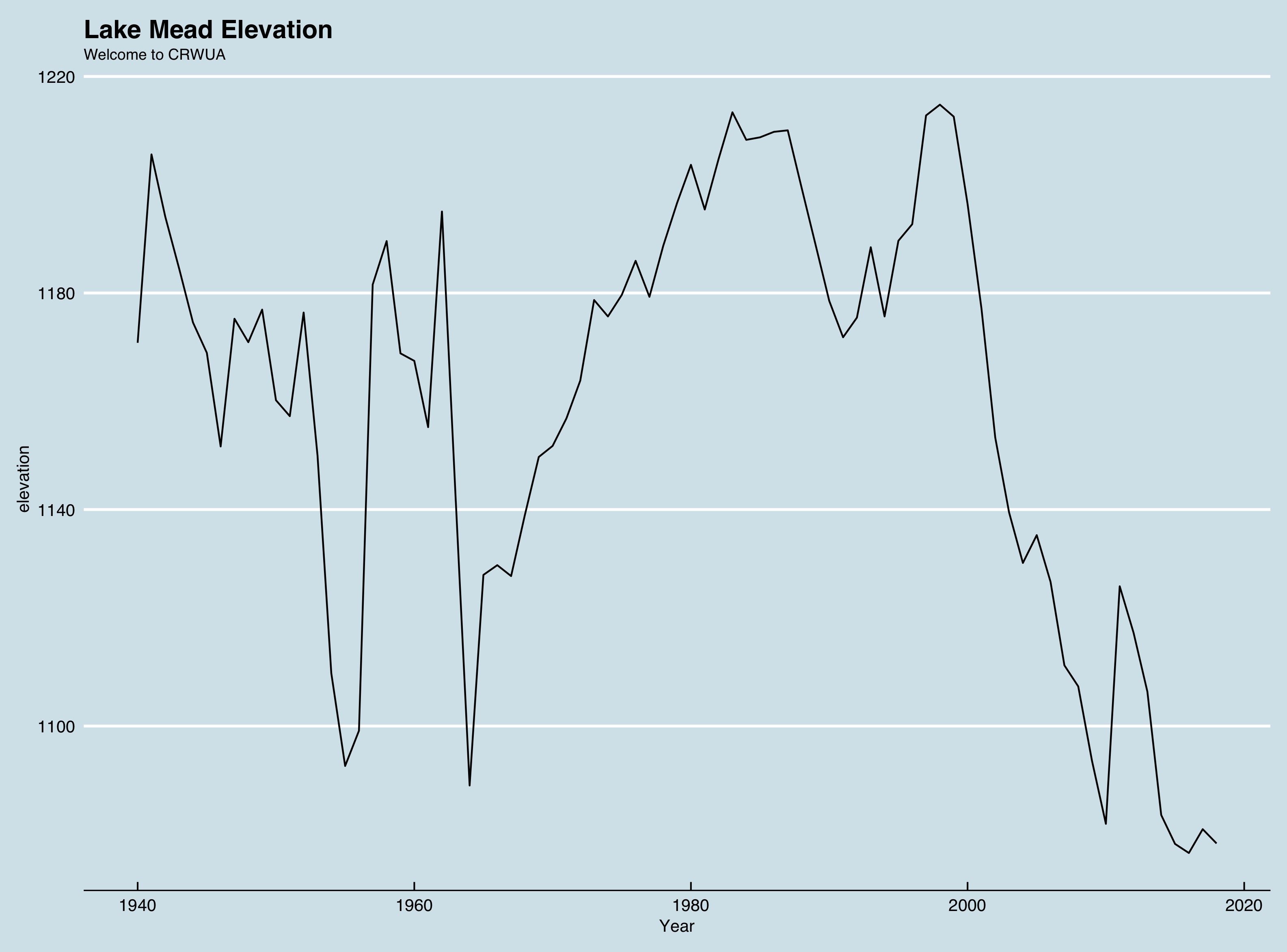
The surface level of Lake Mead, which holds water supplies for Nevada, Arizona, California, Sonora, and Baja, ended November 2018 at 1,078.32 feet above sea level. That is 2-1/2 feet below last year at this time.
I’m moderating a panel on the Lower Basin Drought Contingency Plan at this year’s meeting of the Colorado River Water Users Association in Las Vegas (NV) in a couple of weeks. What shall we talk about?
Arizona’s water agencies, cities, farmers and tribes haven’t quite sealed a Colorado River deal. But they’re getting closer.
The outline of a new compromise proposal emerged this week and was presented at a meeting on Thursday. The plan would help Arizona join in a proposed three-state Drought Contingency Plan by spreading the impacts of the water cutbacks, providing “mitigation” water to farmers in central Arizona while paying compensation to other entities that would contribute water.
That’s the Arizona Republic’s Ian James on the latest in Arizona’s struggle to find a way to scale back its water use as Lake Mead drops.
Here’s some scene-setting data as the Colorado River brain trust prepares to converge on Caesar’s Palace:
See you in Vegas.
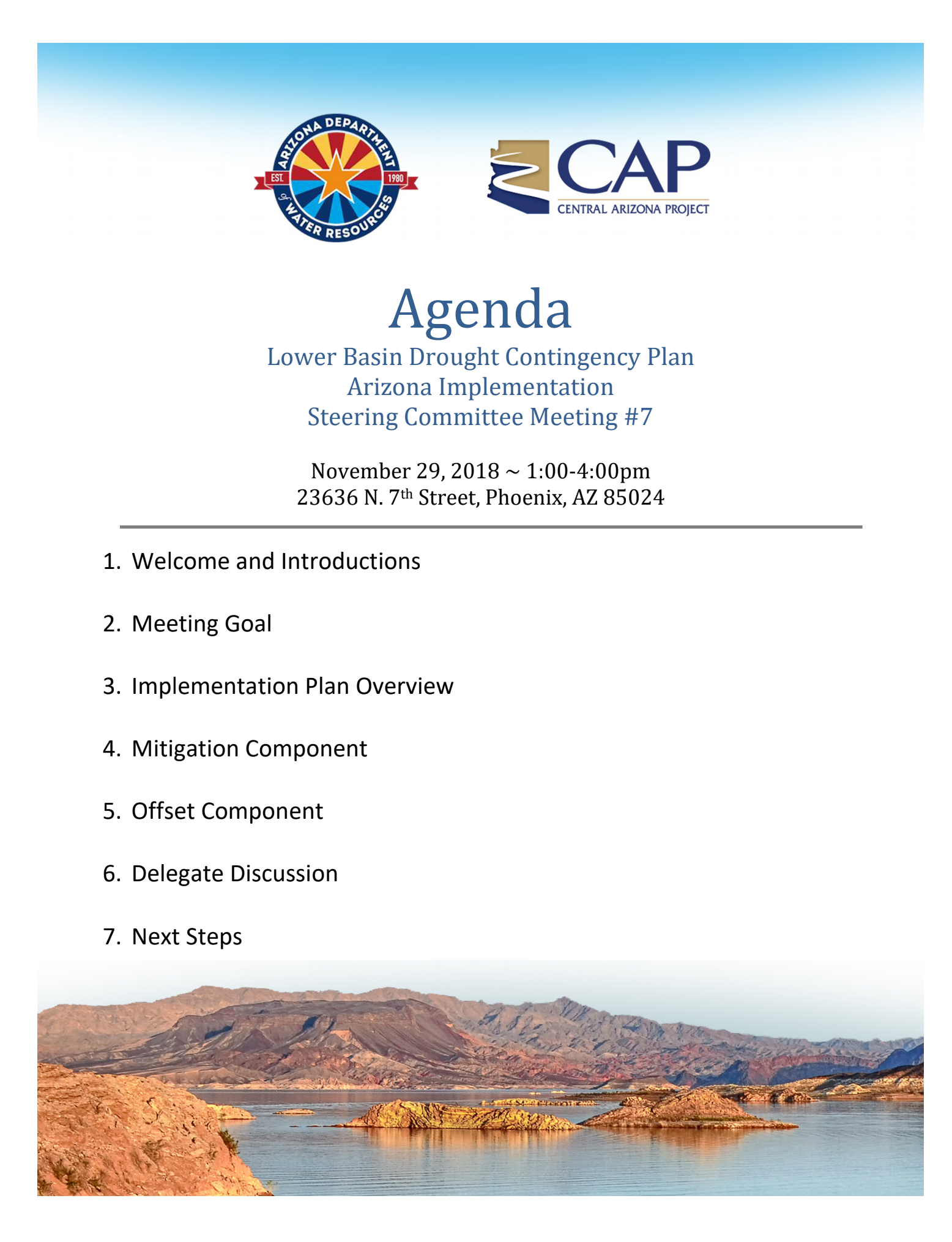
DCP meeting
Update: via Ian James from the Arizona Republic, here are the slides for today’s meeting.
Previously: With the announcement of a meeting this afternoon of Arizona’s Lower Basin Drought Contingency Plan steering committee, it appears we have the general shape of an agreement to settle the thorny issue of how to reduce Arizona’s use of Colorado River water.
Not a lot of details yet, but it appears that
With those three key pieces – GRIC/CRIT, cities, and Pinal County farmers – we seem to have the necessary agreement for a deal. But I have been wrong about Arizona before.
Not sure if the meeting will be livestreamed, and I’m in Albuquerque with a day job, so I’d be ever so appreciative if folks either in the comments here or on the twitters (#ColoradoRiver or the far less poetic #CoRiver) would add what they know.
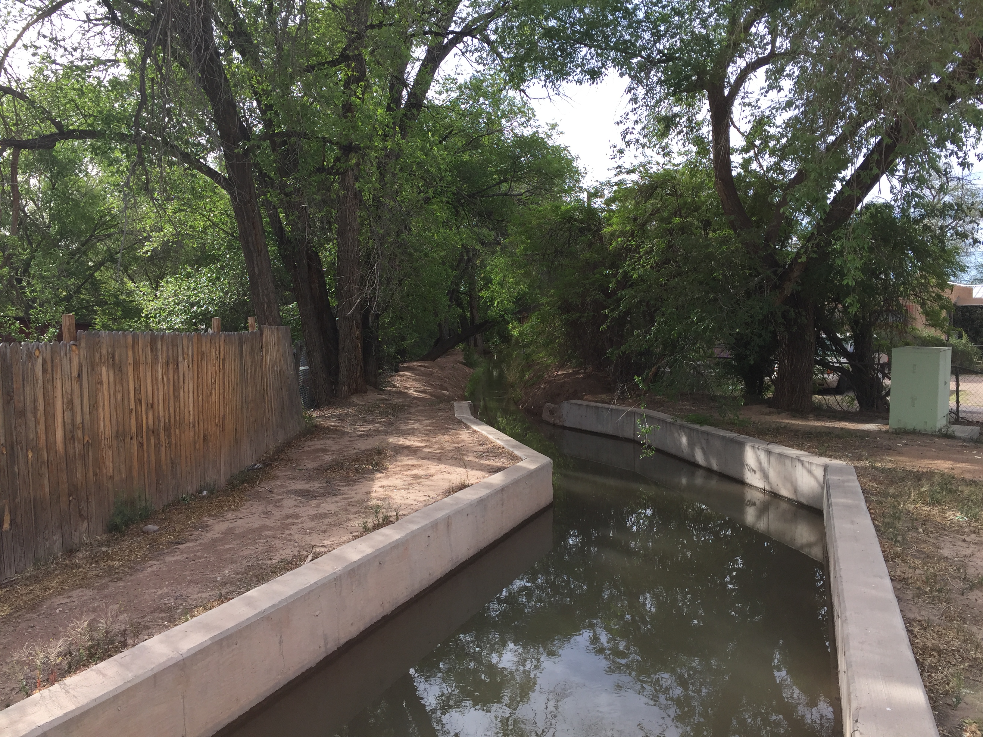
An old irrigation ditch in Albuquerque’s South Valley, updated
Driving in a pickup down a ditchbank on Albuquerque’s valley floor some years ago, Joey Trujillo pointed off to the west, to a line of trees snaking away into what is now a tony suburban neighborhood. It was the neighborhood we now call “Dietz Farm”, named after the Dietz family, affluent interlopers from the east who came to the area during the early decades of the 20th century. Like much of that era in Albuquerque’s history, the people who had the land before the Dietz’s have been erased, but the line of trees has not.
It was a late winter day. Joey was the head ditchrider for the valley, the people who keep the water flowing through the network of irrigation canals that have been here “forever”. I was watching as Joey’s crew carried out a version of a seasonal ritual that dates in this part of the valley to at least 1706, bringing the first water of spring to the valley floor. I say “at least”, because on the old irrigation system inventories maintained by the Middle Rio Grande Conservancy District, there are a bunch of ditches with a 1706 date attached. The implication – this is not the date the ditches first ran, but rather our first surviving inventory of their presence and use.
Walk or ride your bike down the ditchbanks today, and you’ll see modern amenities, as in the concrete intervention in the picture above, often needed to get the old ditches under roadways. You’ll see gates to meter and measure the water’s flow, aptly called “control structures”. But the ditches often still follow routes laid out centuries ago. They are lined with trees tapping into the water seeping into the shallow aquifer from their unlined sides and bottoms. And if you look closely, you can still see the lines of trees left behind when old laterals were abandoned in succeeding waves of suburban development.
I am grateful to the geographer Jeremy Schmidt, who in his fascinating book Water: Abundance, Scarcity, and Security in the Age of Humanity introduced me to the work and ideas of William John McGee, one of the 19th century “naturalists” who, alongside the likes of John Wesley Powell and Gifford Pinchot, framed a bunch of stuff in ways mostly unexamined by me. Until I’m forced to examine them.
I’m in the midst of three projects right now that are converging simultaneously on the questions raised by McGee and Joey Trujillo’s line of trees stretching out through that Dietz Farm neighborhood. The first is the book I’m writing with Eric Kuhn about the use and misuse of the science of the Colorado River, which has prompted a dive into the question of what we mean by “science”. The second is a University of New Mexico project focused on thinking about the “Grand Challenge” of sustainable water. The third is my endless delight in the ideas my students bring to me, in particular a group of students with fresh ideas about what the water problem is that we’re trying to solve. (Wisely, these students are not leaving it to Prof. Fleck to define the problem.)
McGee was secretary of the U.S. Inland Waterways Commission, appointed to the position by Teddy Roosevelt, when he wrote this in a 1909 essay called “Water as a Resource”:
Now is the time of conquest over nature in practical sense, of panurgy in philosophic sense – the day of prophecy made perfect in predetermined accomplishment.
“Panurgy” stumped me, and given the context I’m not sure McGee intended the sense I found when I turned to the Oxford English Dictionary for help: “Interference or mischief-making in all matters; knavery.” But the OED definition adds a nice flavor to our attempt to look back with our 21st century eyes to get a feel for what McGee was on about:
No more significant advance has been made in our history than that of the last year or two in which our waters have come to be considered as a resource – one definitely limited in quantity, yet susceptible of conservation and of increased beneficence through wise utilization. The conquest of nature, which began with progressive control of the soil and its products and passed to the minerals, is now extending to the waters on, above and beneath the surface. The conquest will not be complete until these waters are brought under complete control.
When I took over two years ago as director of the University of New Mexico’s Water Resources Program, one of my colleagues stopped by to congratulate me, talk about our shared passion for water, and to make a longstanding request: Could I please drop “Resources” from my program’s name? Putting water into the conceptual “resource” box constrains our thinking about it, she argued, in ways that are an injustice to the many other conceptual frames that suggest values for its own sake rather than the “conquest” envisioned by McGee a century ago.
I didn’t change the program’s name. But the seed planted has been growing, which I’m guessing was her point.
The university’s “Grand Challenge” risks putting water into the “resource” box again, but after two years teaching and working with my amazing watery colleagues – geographers, landscape architects, historians, economists, hydrologists, engineers, political scientists, artists – I’m beginning to get a feel for the plasticity required to navigate the interdisciplinary nature of thinking about water.
I’m particularly indebted to one of my smart students who’s thinking really hard about those valley ditches. They are rooted in a long tradition of resource exploitation in the style of McGee, turning water out of the Rio Grande and across the otherwise parched spring and summer valley floor, a “conquest of nature” in the 1600s as sure as McGee’s early 20th century conception.
We can ship soy milk in from Iowa now. Those ditches thread through the valley floor in a way no longer needed for the conquest. But they have become something far more than a “resource” in the sense McGee was talking about, something much closer to the broader conception my faculty colleague was getting at when she came to me asking that “resource” be dropped from my program’s name.
Joey Trujillo died a few years ago, but it seems reasonable that the ditches he so carefully helped tend will be here for a long time yet.