A good year on the Rio Grande

We ended up with 1.2 million acre feet of water flowing down the Rio Grande past Albuquerque this year, according to my quick and dirty calculations based on the USGS Central Avenue gauge. That would be the biggest flow through town since 1995.

graph showing high 2019 flow through Albuquerque on the Rio Grande

Rio Grande total flow

That’s 42 percent above the long term mean (this gauge’s data goes back to 1966, the first full year at the site) and nearly double the 21st century mean. Here’s the hydrograph of a good year on the Rio Grande.

Elephant Butte reservoir, the biggest storage on the Rio Grande, ended 2019 with ~557,000 acre feet, the most at years’ end since 2008, but still hovering around “drought of the ’50s” levels (which as you can see really stretched from the 1940s into the 1970s).

Elephant Butte storage, data via USBR

Not sure where we ended up in terms of meeting our Rio Grande Compact delivery obligation to folks downstream, but I’m speaking in a week at the annual New Mexico Water Dialogue, I’ll track down the answer and report back here.

And finally one of my favorite water measures, the aquifer beneath my house was up more than 3 feet in 2019. This is one of the metrics that, as I watched it over time, finally began to persuade me that not all was doom and gloom:

The aquifer rising beneath John Fleck’s house

California’s 2019 use of Colorado River water lowest since 1950

graph showing California's decling use of Colorado River water

Data: Metropolitan Water District of Southern California; USBR. Munging together of datasets by John Fleck, University of New Mexico Water Resources Program

While Colorado River water management eyes were focused elsewhere this year – on the big snowpack up north, or the chaos success of the Drought Contingency Plan – California has quietly achieved a remarkable milestone.

Its use of Colorado River water in 2019 will be 3.858 million acre feet. The last time it was below 4 million acre feet was 1950, as the state’s big diversions – the All-American Canal and the Colorado River Aqueduct – were ramping up.

In our new book Science Be Dammed: How Ignoring Inconvenient Science Drained the Colorado River, Eric Kuhn and I make the obvious plea that decision-making going forward must take seriously the hydrologic science: that the Colorado River never had the water the planners schemed for in the 1920s, and that climate change makes that reality worse. But we also include a plea for taking demand-side science seriously:

There also is an empirical reality on the water demand side that has been insufficiently taken into account, but which provides a significant opportunity to help solve the river basin’s problems once we are willing to take it seriously. The widespread presumption that population growth means growing water demand drives much of the politics of water planning in the Colorado River Basin. But it is wrong. Simply put, we are consistently using less water. In almost all the municipal areas served with Colorado River water, water use is going down, not up, despite population growth. Water use in the basin’s major agricultural regions also is going down, even as agricultural productivity continues to rise. This is not limited to the Colorado River Basin. Such “decoupling” among water use, population, and economies is common across the United States.

In the 2019 California data, I see four things going on, three on the municipal water use side and one on the agricultural.

Southern California municipal water management success

On the municipal side (which means the Metropolitan Water District of Southern California and its best pal the San Diego County Water Authority):

  • A good snowpack in the Sierra Nevada meant Met got a 75 percent allocation from the California State Water Project, which moves Northern California Water to “the Southland”, as we used to call the state’s populous Southern California coastal plain. That’s not a great allocation, but it is a good one.
  • Bangup water conservation success in Met’s service area – publicly available California data suggests total municipal water use across Southern California is essentially where it was back in the 1980s. It’s not clear where the floor is here, but California’s experience during their Big Drought of the teens suggests there is still room reduce water use even more.
  • Aggressive efforts to maximize local supplies – desalination, wastewater reuse, groundwater contamination cleanup, stormwater capture. Expect these numbers to continue to go up.

The result of all that is that the Metropolitan Water District of Southern California, which provides all the water to the coastal cities, will end the year at 536,726 acre feet of use, its lowest use of Colorado River water since 1958.

Southern California ag reducing its water use too

Meanwhile on the agricultural side, California’s big desert irrigation districts also are using less water. Total use this year by the “big three” – Imperial, Coachella, and Palo Verde – is 81 percent of the 2002 peak. A big part of that is the web of agreements among ag and municipal users that allowed California to step back in the early 2000s from its excessive past use of Colorado River water use. The deals are frequently characterized as ag-to-urban transfers, but the more accurate way of seeing them is finding ways to compensate ag communities for absorbing the cuts as California scaled back from 5-plus million acre feet a year of Colorado River water use to its legal entitlement of 4.4maf.

Not just California

California’s low use is the headline grabbiest, but Arizona and Nevada are also using less than their full allocation. As I write every damn chance I get, when people have less water, they use less water. This is the critical point in the bit I quoted above from our new book.

My lovely All-City bicycle atop Hoover Dam, with a bathtub ring in the background illustrating Lake Mead’s great emptiness.

This should in no way be read as a suggestion that all is fine. The obligatory pictures of Lake Mead’s bathtub ring I take every December while on my way to the Colorado River Water Users Association meeting show, well, a bathtub ring, seen from many angles. No way around that.

1,090.44

Mead is ending the year at elevation ~1,090 feet and a couple of inches above sea level (1,090.44 as of 6 p.m. Mountain time as I write this), which means the provisions of section III.E.6 of Exhibit 1 to the Lower Basin Drought Contingency Plan Agreement kick in:

In the event Lake Mead’s January 1 elevation in a given Year is higher than that projected in the preceding August 24-Month Study, any DCP ICS creation that would not have occurred in such Year if the DCP Contribution had been determined based on Lake Mead’s actual January 1 elevation rather than a projection will instead remain available as the type of ICS originally created to the extent such volumes are the result of conservation actions consistent with ICS Exhibits to the 2007 Lower Colorado River Basin Intentionally Created Surplus Agreement (2007 ICS Agreement).

I’ve read that paragraph now ~17 times and I’m getting a headache and that’s no way to spend New Year’s Eve, but it basically seems to be saying that all the August hoopla about the first mandatory DCP cuts is basically “meh” and we end up with more dusty regular old “intentionally created surplus” banked in Mead in the coming year, not the shiny new “DCP ICS” we’ve all been so excited about. But I am not a lawyer, and would be delighted if any of you who have passed the bar can help clarify my thinking.

An interesting exercise for the reader would be to look at the final pumping numbers to see if anyone backed off of their pumping in December to try to nudge the final number above 1,090. Arizona, for example, seems to have diverted ~100k acre feet from the river in December 2019, which is less than half of what it took in each of the previous five Decembers. An extra 100kaf would have been enough to keep Mead above the 1,090 threshold, but I haven’t looked closely at who within Arizona was taking what, nor thought through who might stand to benefit from section III.E.6. As I said, an interesting exercise for the reader.

Colorado River Basin storage – slightly more than half full

Total Colorado River system storage is ending 2019 at 52 percent of capacity. So slightly more than half full, or just a bit less than half empty, depending on your desired framing. My preferred framing is that we figure out how to walk and chew gum at the same time with this stuff – recognizing enormous success without losing sight of how large are the looming problems that remain.


#geographybybike

John Fleck’s 2019 Albuquerque bike rides

With a couple of days left in 2019 I’m at 4,303 miles bicycled for the year, so I made a map. My claimed mileage is almost certainly not accurate to that fourth significant digit, but since I GPS all my rides it’s probably close. There are a few hotel fitness center miles in there, and a few rides when I took my bicycle with me when I traveled (to Colorado, Arizona, and California). But the vast majority of the miles were ridden on the roads of my home town of Albuquerque, New Mexico.

lunch at El Mezquite

My friend Maria Lane (an actual geographer!) dubbed this #geographybybike, a sort of aimless wandering around looking at all the things. A lot of aimless wandering around. A version of the map sans arty black background would show Albuquerque’s river corridor, tracing the trails on either bank. Add a time element and you’d see more and more rides on the valley floor riding ditch banks. A Sunday-specific geography would chronicle a growing relationship with cheap tacos.

I’ve lived in Albuquerque nearly 30 years, and been riding my bike here for 20. I used to be all zoomy and fitnessy, but as I approach senescence I’ve increasingly been about looking around.

It’s given me a fresh sense of my city. There are no bad days on a bike.


great blue heron

great blue heron, Rio Grande Bosque, Albuquerque, New Mexico, December 2019

The first bird I formally identified, as in “sat down with the book and then wrote down the result” was a great blue heron.

The entry in the old family Peterson Field Guide to Western Birds, red ball point pen:

11/86 Sat on tiny island in Colorado River all morning, picking at its feathers

The book dates to the 1960s. Per the inscription in the front, it was a Christmas 1968 gift from my father to my mother. When Lissa and I were married it was passed down to us.

I cannot remember the November 1986 Colorado River blue heron campground with precision. It was on the Lower Colorado, the Blythe stretch I think (North of Blythe? South?) on the Arizona side, I think. There were a few tent spaces, but it was mostly RV’s. We were poor, and tent campers, and went often in the winter months from our home in South Pasadena to the deserts of the Lower Colorado.

When I was young and imagined being a writer (which is almost certainly what I was imagining on that trip in November of 1986 as I sat looking out at that river), I had a character in mind who lived in the desert – out near Joshua Tree, in a mobile home – and learned the names of birds. The naming of things has always seemed important to me:

And out of the ground the Lord God formed every beast of the field, and every fowl of the air; and brought them unto Adam to see what he would call them: and whatsoever Adam called every living creature, that was the name thereof.

The heron, if you believe in such things, has always been a spirit animal for me, following me on my travels. One swooped up into a cottonwood this morning as my friend Scot and I were riding our bikes up through the woods along the Rio Grande, kindly posing, that I might take their picture and remember their name.

How we got into our Colorado River mess (and how we get out of it?)

Bret Jaspers at public radio station KJZZ in Phoenix did a two-part piece starting with a nice overview of our new book, followed by a good dive, from the Arizona perspective, into the options we have for extricating ourselves from the Colorado River’s overallocation problems.

Arizona’s “great forgetting”

I returned to a message I’ve been hammering on regarding what’s going on in Arizona right now:

“In 1968 when the Central Arizona Project was approved, Arizona knew that there was not sufficient water to keep that canal full year in and year out,” Fleck said.

He points to testimony from then-Reclamation Commissioner Floyd Dominy, who told a House of Representatives subcommittee that “sooner or later, and mostly sooner, the natural flows of the Colorado River will not be sufficient to meet water demands, either in the lower basin or the upper basin, if these great regions of the Nation are to maintain their established economies and realize their growth potential.”

Fleck said Arizona knew that without augmentation, the water available for CAP canal customers would fluctuate.

“And somehow that was forgotten, and Arizona grew to depend on a full CAP canal every year,” Fleck said.

As John Berggren pointed out when I pushed on the same point last summer at a conference in Boulder, banging on this point may not be helpful at this point. Arizona did what it did over the last half century, and is where it is now, mistake or not.

It’s hard to disagree with him on this, but I still keep saying it.

Climate Change and rhetoric on the Colorado River

I could see the reporters at last week’s Colorado River Water Users Association meeting chafing at the rhetoric we were hearing regarding climate change. In my strange new role (kind of a reporter, I am writing another book,  and kind of not – I have this crazy university gig) I was invited into the news events, but tried to hang at the metaphorical back, letting the folks with daily deadlines and immediate needs ask most of the questions.

And regarding climate change, ask they did. Here’s how the Arizona Republic’s Ian James characterized the scene as he explained the comments made by Interior Secretary David Bernhardt:

He didn’t mention the words climate change during his speech at the conference. But during a press conference afterward, reporters asked Bernhardt about the role of climate change.

“I certainly believe the climate is changing,” Bernhardt said. “I spend a lot of time with our scientists, and I spend a lot of time with our models. And you know, what the scientists tell me is that the best thing we can do is make sure that if we’re using a model, we use multiple models and multiple ranges within each model. And so that’s what I’ve insisted on when we’re looking forward to the future.”

In projecting the river’s flows into the future, he said, “we absolutely follow best practices all the time.”

After Bernhardt’s news “gaggle”, I put on my university professor hat, echoing in part an argument I’ve been hearing articulated with increasing clarity by Brad Udall:

John Fleck, director of the University of New Mexico’s Water Resources Program, said Bernhardt’s comments reflect a dichotomy within the federal government in which officials are taking steps on climate adaptation but not on combating planet-warming emissions.

On the one hand, water managers at the Bureau of Reclamation are working with scientists and using climate models to assess risks and project the river flows into the future, Fleck said.

“They’re absolutely taking climate change seriously. It’s built into the modeling work they’re doing,” Fleck said. “You don’t find water managers doubting the reality of human-caused climate change and its effects. They’re seeing it in the flow in their systems, and they’re dealing with it.”

On the other hand, he said, there is a “disconnect” in that the Trump administration isn’t taking steps to reduce greenhouse gas emissions.

“So that increases our risk,” Fleck said. “That’s a problem because we need to reduce greenhouse gases to mitigate the effects on the Colorado River.”


Tribal Water and the Colorado River: thoughts on the recent CRWUA meeting

By Eric Kuhn

One of the central themes of last week’s Colorado River Water Users Association annual meeting was the was the role of the basin’s Native American Tribes in the many decisions that will guide and manage water use on the Colorado River over the next several decades (for example, the post-2026 Guidelines). CRWUA attendees heard a report on the Water and Tribes Initiative co-facilitated by Matt McKinney and Daryl Vigil.

Tribal Water Study

While our book, Science Be Dammed, is primarily about the science (hydrology) of the river – What did we know, when did we know it, and how did we use it? – the research John Fleck and I did has given us some interesting insights on the how the basin states and federal agencies that dominated the development of the river viewed the water needs and rights of the Tribes.

Those familiar with the Law of the River know that the 1922 Colorado River Compact addressed the Indian questions with a single sentence.  Article VII states “nothing in the compact shall be construed as affecting the obligations of the United States of America to Indian Tribes.” The provision was put in the compact at the insistence of Chairman Hoover.  His original suggested language was “nothing in the compact shall be construed as affecting the rights of Indian tribes.” The minutes give scant reason for the language change that Hoover himself suggested. (Hundley, Water and the West, pages 211-12).

Based on the compact minutes and Hoover’s 1923 report to Congress, he considered the federal obligations to Indians as similar to future treaty obligations with Mexico. He considered both as core federal interests. Before the compact negotiations began, Mexico requested that it be formally represented on the commission. At the request of the State Department, Hoover responded that the compact was solely a domestic matter, but Mexico need not worry. Its rights could be determined by a treaty and “such treaty rights” he noted “will override interstate arrangements” (Hundley pages 175-6). During the negotiations Hoover cautions that without Article VII, Congress would include a reservation to protect tribal rights under treaties (Minutes of the 21st Meeting). In his analysis of the compact for Congress he notes that the provision disclaims “any intention of affecting the performance of any obligations owing by the United States to Indians” and “it is presumed the that the States have no power to disturb these relations” (The Colorado River Compact: Analysis by Herbert Hoover, January 30, 1923, answer to question #24).

In Water and the West, Hundley is critical of the commission, concluding that “no attempt was made to discover how many Indians were in the basin and what their water needs were. The Commission simply assumed that the water rights of Indians were ‘negligible'” (pages 211-12). Here, as with our message in Science Be Dammed, reality is more complicated. While there is no reason to disagree that the commission assumed the rights were negligible, the available technical reports suggest that, at least in the Lower Basin, the future needs of Indian tribes were well recognized and far from negligible. The 1922 Fall-Davis Report, the Reclamation Service report that shaped both the compact and the 1928 Boulder Canyon Project Act, identifies over 140,000 acres of tribal lands adjacent to the river below Hoover Dam that could be irrigated, including the Colorado River Indian Tribes and Ft. Mojave Projects, very similar to the Indian rights that were finally adjudicated in Arizona v. California.

The conclusion of the recently completed Tribal Water Study that the water rights of the tribes exceed 2.9 million acre-feet might have surprised some, but it should not have. By 1944, when the Bureau of Reclamation’s comprehensive report on the development of the Colorado River was being finalized, the Bureau of Indian Affairs identified existing and future Indian projects that would divert (not consume) over three million acre-feet per year of water, including over 800,000 acre-feet in New Mexico (Proceedings of the Committee of 14/16, November 10-11, 1944).  Because it acknowledged that Indian rights would be “superior” to non-Indian rights, the Upper Colorado River Basin Compact Commission gave New Mexico an 11.25% share of the Upper Basin’s apportionment (New Mexico provides <2% of the river’s yield) so that it would be large enough to cover the future needs of its Native and non-Native Americans.

For most attendees, the convention’s attention to the basin’s Tribal needs was a welcome and perhaps overdue step. The message I heard was that the basin’s Native American communities are fully engaged and expect that they will be given the opportunity to meaningfully participate in the decision-making processes that will shape the future of the Colorado River.  In his remarks, Secretary Bernhardt appeared to offer them a seat at the table. Even so, history suggests, they will still have many challenges ahead of them.

Hoover Down: the next in a series

A frieze on Hoover Dam includes descriptions of all the dam's legally authorized uses

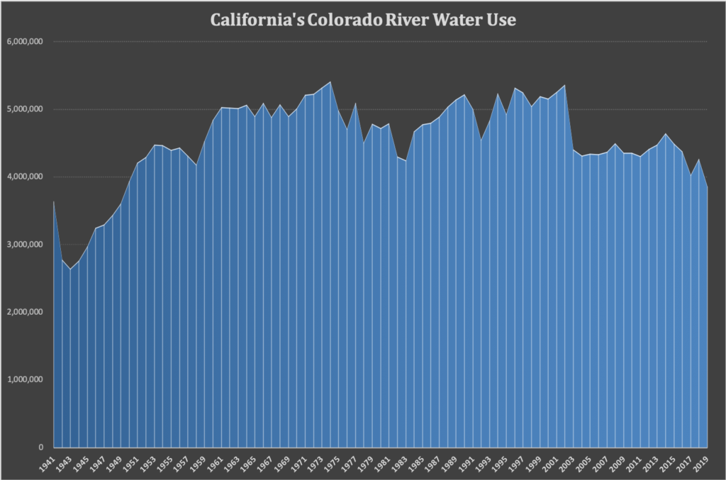
The Boulder Canyon Project Act, carved in stone

Touring Hoover Dam Friday afternoon, a friend deeply embedded in the “Law of the River” asked if I knew that Section One of the 1928 Boulder Canyon Project Act was carved in stone on one of the Dam’s iconic towers:

Be it enacted by the Senate and House of Representatives of the United States of America in Congress assembled, That for the purpose of controlling the floods, improving navigation and regulating the flow of the Colorado River, providing for storage and for the delivery of the stored waters thereof for reclamation of public lands and other beneficial uses exclusively within the United States, and for the generation of electrical energy as a means of making the project herein authorized a self-supporting and financially solvent undertaking, the Secretary of the Interior, subject to the terms of the Colorado River compact hereinafter mentioned, is hereby authorized to construct, operate, and maintain a dam and incidental works in the main stream of the Colorado River at Black Canyon or Boulder Canyon…. (emphasis added)

The carving (or maybe it’s cast concrete? further research needed) sits atop the Nevada side elevator tower, and as we were finishing our tour, we lingered on top of the dam, thinking about the implications.

I apologize for the picture. The light wasn’t great. I tried going back early Saturday morning, hoping sunrise light would highlight it better, but alas I think I need to return in spring or summer, when the rising sun might cast the shadows that would better highlight this institution carved in stone. (I do not view a need to return to Hoover Dam as a problem.)

I’ve got a couple of working titles for the next book on which I’m starting to work. “The Ghost of Water” has been my go-to in the last few months as I begin to sketch out the ideas, but as I toured the dam with old Colorado River friends Friday I added one to the mix: “Hoover Down“.

The idea is that we create institutions, and then those institutions shape the land. In between institutions and land sits Hoover Dam.

By “institutions” here I mean not government agencies, but the more expansive definition we teach University of New Mexico Water Resource Program students:

Institutions – the rules of the game, both formal and informal, that both liberate and constrain behaviors in repeated interactions

It’s wonky language, and it took me a while to get my head around the distinction between this expansive definition and the more traditional “institution = government agency” idea. At Hoover Dam, the institution in question is in significant part the Boulder Canyon Project Act of 1928. (The more traditional idea of what people mean when they talk about institutions, the Bureau of Reclamation, is in this case the tool we use to carry out the rules written down by Congress in 1928.)

In retrospect, there’s a thread in the three books I’ve written that leads in this direction:

  • The Tree Rings’ Tale, written for kids, was mostly, “Hey, science about water, how cool is that?”
  • Water is For Fighting Over tackled the interplay between the “formal” and “informal” parts of the definition of institutions, and the operation of “the network”. It’s my attempt to make sense of the institutions.
  • Science Be Dammed, thanks to the remarkable insights of my co-author Eric Kuhn, brought the science and the institutions together in a way I think frankly has never been done for the Colorado River.

Hoover Down

During our tour Friday, the kind folks at the Bureau of Reclamation took a group of us down on the power plant floor, where in our post-9/11 world tourist tours no longer go. Standing amid the massive generators on the Arizona side, it was weirdly quiet. There was very little water flowing through Hoover Dam. Why?

Hoover Dam

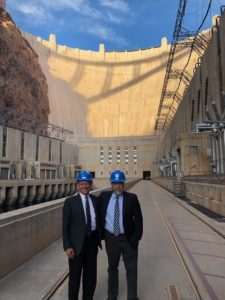
friends with the keys gave us a tour of the place

Part of the reason is the changing nature of the power grid. Hydroelectric power plays an increasing role in filling in behind renewable resources when they go off line, so Hoover’s generators tend to ramp up when the sun sets in California.

But part of the reason involves the shifting nature of water management uses and rules downstream. There is simply less water moving through the dam than there used to be. The complex tangle of rules – institutions – is successfully encouraging folks downstream to bank their water in Lake Mead rather than taking it out and spreading it across the land.

Mexico’s water agency notified the U.S. government that it wanted to cut its releases this month and store water in Mead, something that would have been impossible under the rules ten years ago. As I’ve written before, the Metropolitan Water District of Southern California will take less water out of Mead in 2019 than it has in any year since the 1950s.

The result is that the Bureau’s current operating plan calls for releasing just 225,000 acre feet of water from Lake Mead in December 2019. I went back through a decade of USBR records (more research clearly needed, this is fascinating!) and that is by far the lowest December release I found.

The idea behind “Hoover Down” is that the dam acts as a funnel that translates rules into moving water. Downstream, that water spreads out across the landscape. As the rules change, the volume of water flowing through the dam changes, and the landscape from Hoover down – not just the river corridor itself, but all the places beyond that use its water – changes as well.

There are a lot of places I could tell this story. I’m thinking about “Hoover Down” in significant part because of my love for that part of the Colorado River Basin – the basin of my childhood.

CRWUA – hitting “pause”

Friday’s tour was a coda to last week’s meeting of the Colorado River Water Users Association. Rules were the primary focus of the discussion, and a part of the work for “Hoover Down” will involve a close examination of the work over the next “n” years on a new, or newly revised, set of rules for how much water enters and leaves Lake Mead. The value of “n” itself is an interesting uncertainty in the whole thing. This book may take a while.

It was a “no big news” CRWUA, the kind where I was glad I wasn’t a beat reporter any more having to gin up a quick story. Ian James (who also joined the tour) turned a nice daily that focused on the key element. Rather than quickly going on to the next phase of “Law of the River” negotiations, Interior is hitting the “pause” button for a year long review of how the current river rules are working.

Speaking on the day’s final session, Interior Secretary David Bernhardt emphasized some interesting points, including the need for the next round of “Law of the River” negotiations to include Native American and environmental NGO interests. An Interior Secretary CRWUA speech is about signalling – that was a particularly important signal. How it translates into action remains to be seen, but the marker has been very publicly placed on the board.

As I think back to book two in “the series”, about how the network functions both formally and informally, I’m intrigued by the way the pause creates some space for informal discussions about what folks want the next round of rule discussions to look like and include.