Breaking through the Colorado River clutter: Science Be Dammed

Eric and I could not be more happy about this from John Berggren.

There are countless Colorado River resources available to learn about the history of how the river has been and continues to be governed. Hundreds of books, reports, studies, and papers have been written on the subject. Accordingly, it takes something quite new and novel—and credible—to break through the masses and rival Colorado River classics such as Norris Hundley, Jr. and Marc Reisner’s work. Eric Kuhn and John Fleck have undoubtedly done exactly that in their new book Science Be Dammed: How Ignoring Inconvenient Science Drained the Colorado River.

John, who did his doctorate at the University of Colorado studying Colorado River governance, now works for Western Resource Associates, and is one of the smart next generation of water thinkers whose help we need to get out of our current mess(es), argues thus:

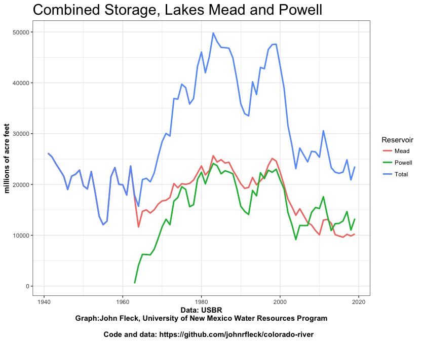
If you have ever seen a talk or lecture about the Colorado River, you have almost certainly heard the refrain: when the negotiators divvied up the river in 1922, their period of record for streamflow was unusually high. They believed the river’s annual flow was at least 17.5 million acre-feet (MAF) and able to supply what the states could reasonably develop in the coming decades. Unfortunately, that 17.5 MAF ended up being much higher than the approximate 14 MAF we see today and because of that, they accidentally over-allocated the river.

But as Kuhn and Fleck dug into the record, they discovered the reason for over-allocation was more complicated, nuanced, and ultimately political rather than scientific.

But that was not the only time….

What becomes especially troubling is that Kuhn and Fleck continue to find this trend throughout the rest of the 20th century as further agreements were decided upon, water infrastructure projects were proposed and built, and we saw the continued evolution of Colorado River governance, known collectively as the “Law of the River.”

The full review is in Water Alternatives, an interdisciplinary journal on water, politics, and development.

Some more Colorado River 2019 data updates

We’re diving into a semester studying (and modeling) Colorado River management in the University of New Mexico Water Resources Program. We’ve got a smart group of next-generation water managers, and we’ll be using the Goldsim modeling platform to build some system models. The students will be helping me think through the set of questions folks in basin management are grappling with as we think about what the management rules, due by the end of 2025, should look like.

Getting ready for class this week, I realized I hadn’t updated my datasets, which we’ll be using in class. I’ve put a few of them on Github, data I’ve assembled that isn’t easily accessible in a single place and that I find useful. One of the important things I’m trying to help students with is the endless and important task of data hustling in the service of policy analysis. Here’s an updated version of the graph of storage in Lake Mead and Lake Powell, with water-year end final numbers.

Water storage in Lake Mead and Lake Powell


Tracking the Colorado – flow at Lee’s Ferry

2019 flow on the Colorado River at Lee’s Ferry

One of the things I do with the students in my University of New Mexico Water Resources classes is try to develop the habit of paying attention, through repetition, to the available data on the systems we’re talking about.

We use USGS river gauges to do this – checking the gauges is a classroom routine.

This spring, we’ll be focused on the Colorado River. Class starts next week, and in getting into the rhythm myself I made the above graph of flow at Lees Ferry, the gauge just below Glen Canyon Dam, at the head of the Grand Canyon. It’s arguably the most important river gauge in the West (Eric Kuhn and I wrote a book about that and some other stuff, we have a whole section explaining why “Lees” has no apostrophe) but as I plotted the 2019 Lees Ferry flow I couldn’t help but feel like this is a very boring graph. Flows are, umm, stable.

Getting my students to start paying attention to this particular gauge may not achieve my pedagogical goals.

A rising Lake Mead? Or just hovering around a new elevation line

Lake Mead elevation. USBR graph

A member of the Colorado River brain trust argues that when you use reservoir elevation to define an action level of some sort, the reservoir remarkably ends up hovering around that level. The updated annual USBR Lake Mead elevation chart, just published with the 2019 data, nicely illustrates their point.

The 2007 Interim Guidelines set elevation 1,075 as the action level for the first tier of Lower Basin water use reductions. When the reservoir drops to that level (insert complicated rules about how and when the determination is made), cutbacks. You can see that in the years that followed, Mead dropped toward 1,075. In fact it actually dropped past it in 2015 and 2016 but bounced back sufficiently that we never actually triggered the cutbacks.

This year, the Basin community adopted new rules under the “Drought Contingency Plan” that created a horribly named “Tier Zero”, with cutbacks now triggered at elevation 1,090 (insert an even more complicated layer of rules about how and when the determination is made).

Mead’s lowest 2019 elevation was 1,081.47 on Jan. 1. Its highest elevation was at midnight Dec. 31, at 1,090.49.

Hovering around the line.

The risk of Southern California falling into “perfect drought”

Last year was, for Southern California water management, perfectly wet. By that I mean a good snowpack in the Sierra Nevada and the Colorado River Basin.

I’m stealing a wonderful phrase here from a new paper by the University of Arizona’s Connie Woodhouse (the full paper’s behind a paywall): “A Long View of Southern California Water Supply: Perfect Droughts Revisited.”

The impact of drought on water resources in arid and semiarid regions can be buffered by water supplies from different source regions. Simultaneous drought in all major source regions — or perfect drought — poses the most serious challenge to water management. We examine perfect droughts relevant to Southern California (SoCal) water resources with instrumental records and tree?ring reconstructions for the Sacramento and Colorado Rivers, and SoCal.

Woodhouse and colleagues found five “perfect droughts” in the 20th century, which they concluded was not unusual when they used tree rings to extend the record back in time. But….

Although the causes of perfect droughts are not clear, given the long?term natural variability along with projected changes in climate, it is reasonable to expect more frequent and longer perfect droughts in the future.

Megdal honored

picture of Sharon Megdal

Sharon Megdal

Happy to report that my friend Sharon Megdal, head of the University of Arizona Water Resources Research Center and a member of the Central Arizona Water Conservation District Board, has been honored with the University Council on Water Resources Warren A. Hall Medal.

Sharon’s a wonderful example (and role model for me as a new academic) of community-engaged scholarship, spanning the boundary between the university and the water management world.

A dry summer and fall means less water in the Colorado River in the coming year

a lousy monsoon

soil moisture heading into the 2020 runoff, courtesy CBRFC

Despite an above-average snowpack in significant parts of the Colorado River Basin, the initial 2020 forecast is for below-average runoff thanks to a dry summer and fall.

According to the Colorado River Basin Forecast Center’s Cody Moser, speaking in today’s first-of-2020 forecast briefings, the monsoon over the Colorado River Basin was the 9th driest and 3rd hottest in a record that goes back to 1895. That means very dry soil moisture heading into the snow season. And that dry soil must then soak up the first pulse of melt before water can get to the rivers.

With three months of snow season to go, the error bars are still huge, with a forecast mean flow into Lake Powell of 82 percent. Pictures here courtesy CBRFC, click for more forecast maps and information than you could every think of asking for.


The problems of a rising Lake Mead

The folks running Lake Mead’s marina – often a story line for folks like me writing about a declining western water supply as marina managers chase a shrinking reservoir’s shoreline – are running the opposite direction this year:

In 2003, they had to relocate the marina to the south 12 miles because the water was going down so quickly.

“We had to take the dock apart in pieces and put it back together and we had to put utilities and everything here, which we paid for too,” said Kaiser.

But now they have to deal with the higher waters, a new increasing out of the pocket expense.

“We’ve ordered in another section of walkway so hopefully we can just add walkway,” said Kaiser.


How big was Lake Mead’s “structural deficit” in 2019?

With Lake Mead ending 2019 at elevation 1090.49 feet above sea level – up 9 feet for the year – it’s worth visiting the Bureau of Reclamation’s classic “structural deficit” slide and seeing how it compares to 2019’s real world data. First, a reminder of where the oft-quoted “1.2 million acre foot structural deficit” comes from:

the structural deficit

Now, let’s compare that to 2019 data, and to a “what if” scenario:

Structural deficit slide20192019 with an 8.23 release
Inflow9.010.19.3
Outflow-9.6-9-9
Evaporation-0.6-0.5-0.5
Balance-1.20.6-0.2

Look, no structural deficit this year!

Well, sorta. In order for Lake Mead to rise that much (the biggest one-year rise since the monster runoff of 2011), we needed

  • reduced lower basin use (it’s the lowest it’s been since 1986, and in the case of California since 1950) and
  • the release of 9 million acre feet from Lake Powell – above the Law of the River-mandated 8.23 million acre feet and
  • a good year on the Colorado’s tributaries between Lake Powell and Lake Mead (they added ~1.1 million acre feet, above the recent average of ~800,000 acre feet)

Absent all that bonus water, the Lower Basin, despite its lowest use since 1986, would still have a deficit to deal with.