Retiring coal plants as a Colorado River Basin demand management strategy

OK, “strategy” is not exactly the right word here, but we take our water conservation where we can find it, eh?

Luke Runyon took a nice dive into the water supply implications of the West’s wave of coal plant retirements. Because coal plants use water. Here’s my coauthor Eric Kuhn on the implications:

“As a legal matter, the owners of the water rights, at least in Colorado, could do something else with them. As a practical matter, there’s not much else they can do with them,” said Eric Kuhn, former head of the Colorado River District and author of Science Be Dammed: How Ignoring Inconvenient Science Drained the Colorado River.

TriState has limited options with the water rights, Kuhn said. The energy provider could sell them to a local municipality, though communities along the Yampa River, like Steamboat Springs, Hayden and Craig, likely wouldn’t be able to use that much water all at once. TriState could offer them to local farmers, though most of the easily irrigable land has already been irrigated for a long time. They could turn them into in-stream flows. Or they could sell them to a user outside the Yampa basin, like a Front Range city. Any project proposed to pump the plant’s freed up water more 200 miles eastward would face significant political pushback and a multi-billion dollar price tag, Kuhn said.

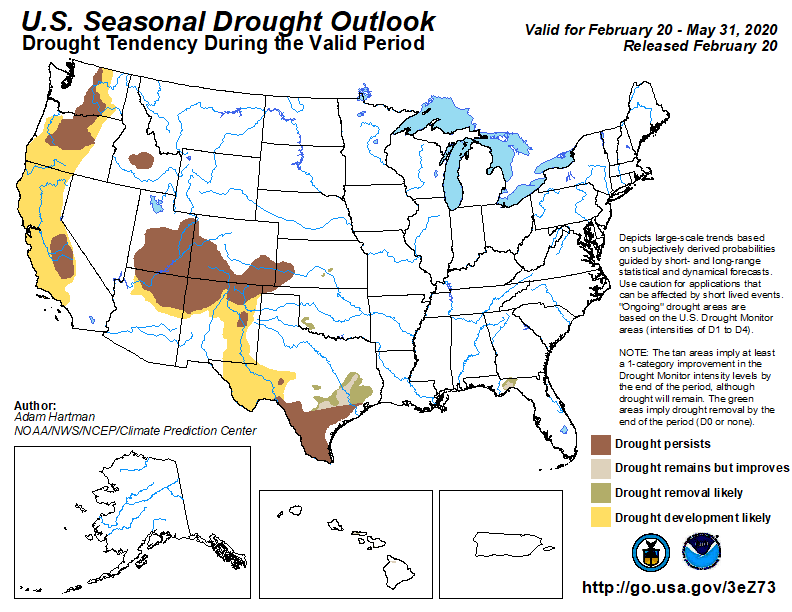
According to Kuhn, these coal closures also have implications for broader Colorado River management. The recently signed Drought Contingency Plans task water leaders in Colorado, Utah, Wyoming and New Mexico to begin exploring a conceptual program called demand management, where in a shortage, water users would be paid to use less. Coal plants using less water would alleviate the situation.

“What it’s going to do is take the pressure off of these states to come up with demand management scenarios, because where does that water go? It’ll flow to Lake Powell,” Kuhn said.

The Future Lake Powell: Feb. 20, Moab

update: It’s apparently at 6 p.m., not 6:30, thanks to alert reader!

My coauthor, Eric Kuhn, will be joining a bunch of other Colorado River smart people tomorrow (Thurs. Feb. 20, 2020) in Moab for an event organized by Utah State’s Center for Colorado River Studies:

February 20, 2020 — The Future of Lake Powell Forum

A forum discussion on what politics, policy, and climate change have in store for Lake Powell.

Since the Colorado River began filling Glen Canyon in 1963, the future of Lake Powell has been up for discussion. Climate change, politics and water-use policy all now factor into the fate of this vast reservoir in southern Utah. Water levels have continually dropped over the past two decades — and without a change in how the Colorado River is managed, water levels could eventually become too low to produce power, to go boating, to store water, and to meet downstream delivery demands.

Thursday, February 20, 6:30 6:00 pm

Historic Star Hall, Moab, Utah

Free and open to the public!

More on California’s 2019 Colorado River water use

A friend sent me an illuminating table that does a nice job of adding perspective to something I’ve written about several times here – California’s stunning reduction in its use of Colorado River water.


agency20022019change
MWD1,238535-703
PVID541353-188
Yuma (California side)6140-21
IID3,1532,562-591
CVWD33134615
other4216-26
Total5,3663,852-1,514

Data in thousands of acre feet.


“in tribute to a million acre feet” – Herbert Hoover and Arizona’s Gila water

“W.S. Norviel from Herbert Hoover – in tribute to a million acre feet and a fine associate”

My thanks to a friend who recently pointed me, as we discussed the appropriate ways to account for Arizona’s use of tributary Colorado River water, to the above bit of history.

In the official transcript of a 1946 congressional hearing, which was then gleefully repeated down through the years (you can see it on p. 281 here) is a hilarious memento of one of the most puzzling pieces of Law of the Colorado River history.

After the main bit of Colorado River Compact business, Article III(a), allocated 7.5 million acre feet each to the Upper and Lower Basins, Article III(b) slipped in some bonus water:

In addition to the apportionment in paragraph (a), the Lower Basin is hereby given the right to increase its beneficial consumptive use of such waters by one million acre-feet per annum.

What does that mean? Who gets the extra million acre feet? From where?

It’s Arizona’s water, of course, to allow it consume within its state boundaries the waters of the Gila River and its tributaries. (Eric Kuhn and I, with the help of the folks at the University of Arizona Press, spilled no small amount of ink on the accounting for, and implications of, the use of that water.)

But in the years that followed the negotiation of the Compact, Arizona was repeatedly at pains to remind everyone that III(b) was their water. The evidence was there, in the caption to the signed photo Herbert Hoover, who headed the commission that negotiated the compact, gave W.S. Norviel, Arizona’s representative.

By 1922, Arizona was already fully using the waters of the Gila and its tributaries, and Norviel was by all accounts emphatic that any Compact agreement not jeopardize that use. The negotiations behind III(b) are poorly documented. But we have the photo, and an accompanying note, sent two days after the Compact’s 1922 signing.

Hoover to Norviel

Levels of uncertainty on the Colorado River

One of the great lessons of the last two decades on the Colorado River is the futility of the “search for certainty”. No one number for “the flow of the Colorado River” can allow us to plan for the future. We face the formidable task of building a river new management framework that is robust to the challenges of deep uncertainty.

Jian Wang, David Rosenberg, and colleagues at Utah State’s Center for Colorado River Studies have a valuable new paper that provides a helpful framework for the task.

Deep uncertainty on the Colorado River

I’ve been involved a bit in the discussions as Wang, Rosenberg, and colleagues were developing the paper (I’m on the advisory panel for their Future of the Colorado River Project) and I’ve found their framework super helpful in thinking about the issues Eric Kuhn and I wrote about in our new book, both in terms of what happened in the past and in planning next steps.

The problems Eric and I describe in the development of the river over the first half of the twentieth century look an awful lot like a failure to squeeze the Colorado’s messiness into a “Level 1” certainty box. The river’s developers tried to estimate a single number for “the flow of the river”, and did so badly. It’s easy to see the mess created when they got the number wrong – trying to squeeze 17.5 million acre feet of allocation into a 13 million acre foot river. But the deeper problem was in thinking there was a single number at all.

By the 1960s, we began to see a more probabilistic approach, implicitly recognizing “Level 2” uncertainty. Folks had realized they didn’t have 17.5maf to work with, and further that the river’s ups and downs meant planning for a range rather than a single number.

River management does a far better job today of Level 2 thinking, with serious probability modeling that includes paleoclimate stuff (using tree rings) and climate change modeling of the future.

What we’ve not done is find our way to methods for Level 3 thinking – far more variable phenomena for which we don’t have the modeling tools to even build a meaningful probability curve. How do you develop management tools for that?

The new Wang et al. paper takes a helpful stab at framing that thinking.


In praise of rail lines and ditchbanks

an old pickup in Valencia County, New Mexico, in the Rio Grande Valley south of Albuquerque, repurposed as a water pump

Somewhere around Mile 22 of a long Sunday bike ride, my friend Scot motioned to a dirt road off to the left, crossing the railroad tracks. “We’re turning there,” he said.

Albuquerque<->Belen via bicycle and Rail Runner

The ride down New Mexico state highway 314, through Albuquerque’s South Valley, across Isleta Pueblo and into Valencia County, is a lovely one, urban giving way to rural clutter, the farm fields growing larger the farther south you get. But it is a long way, and I am old and slow, so I haven’t done it in ages.

Scot’s suggestion that we ride our bikes to Belen and catch the 12:45 Rail Runner commuter train back to town, combined with the warmest Sunday of the year so far, made for a fine outing. Public transit as a bike ride extender!

Scot and I have ridden together for many years, and in so doing have developed a trust in one another’s “let’s try this” ideas. The Rail Runner suggestion was smart – Scot’s “let’s turn left across the railroad tracks” was genius.

Off the highway (lovely, but it’s a highway) we spent much of the next 20 miles riding Middle Rio Grande Conservancy District ditchbanks, dirt roads that flank the district’s canals.

The District is the irrigation, flood control, and drainage agency in our reach of the Rio Grande, stretching from Cochiti in the north to the Bosque del Apache National Wildlife Refuge in the South. The District’s works support a narrow ribbon of green threaded through New Mexico’s largest population center. A central theme of the new book I’m starting to think about is the way water management institutions shape landscape – riding the MRGCD district’s is totally work related.

Highways are highways, you can see ’em anywhere. But the way the ditchbanks (and really the ditches themselves) stitch together irrigation communities is a different thing entirely. They feed water onto farm land – mostly growing alfalfa to feed livestock. They drain water away, or the valley floor would be a swamp in many places. And their roads are roads of a certain type – slow, and measured, and important.

They’ve been there nearly a century, and their predecessor infrastructures far longer, and I’ve been pondering what happens if we talk about them in the same breath as we talk about “nature”.

I’m not quite sure where we were when we came upon the slowly growing sound of sandhill cranes. Their honks are characteristic of the valley at this time of year, but this was a volume and intensity I rarely hear.

Sandhill cranes at a feed lot, Valencia County, New Mexico, February 2020

There were hundreds of them (500, a thousand? My bird counting skills were overwhelmed.), hanging with the cattle and in the adjacent waste pond. The picture above cannot do justice to the smell.

We build impressive wildlife and game refuges for the cranes. Also, feedlots. The boundaries we draw between “nature” and “not nature” yield usefully to inquiry.

Thanks to Scot’s wayfinding skills, we found our way back into Belen in time to grab some deli sandwiches at the Lowe’s Market on main street and catch the 12:45 Rail Runner home.

bikes on a train (technically from last week’s outing – this bike<->train thing is a thing – but the picture I took this week was jumbly)

The Rio Grande’s shrinking snowpack

A dry January in the Rio Grande headwaters means a shrinking runoff forecast.

  • Otowi (the Compact measurement point on which New Mexico’s Texas delivery obligation is based): 78 percent, which is down from 90 percent on January 1.

Still big error bars, because the most important variable is how much snow we get in February and March.

Taking New Mexico’s Gila water from the San Juan?

Old John Fleck would have happily explained to you why this from Bruce Babbitt is a terrible idea:

Damming the Gila River is a vampire proposal that would suck the life out of Southern New Mexico’s most treasured wild and scenic river.

Gov. Michelle Lujan Grisham wants to kill the project. Both of New Mexico’s U.S. senators have tried to withdraw federal funds. Public opinion is against it. But like the vampires of legend, it refuses to die.

A better alternative is to take New Mexico’s water entitlement from existing dams on the San Juan River in Northern New Mexico.

New John Fleck is intrigued, based on a recognition that we need to find ways to expand the policy option space for dealing with Colorado River governance in the coming five years.

On the “terrible idea” side of the ledger is the breaking of one of the Law of the River’s great taboos – moving water across the Upper Basin-Lower Basin Lee Ferry boundary. Taking Gila River water (Lower Basin water!) from the San Juan (an Upper Basin tributary!)? And then, once we get the water across the continental divide into the Rio Grande Basin, we have yet another boundary to cross in the form of the Rio Grande Compact’s bizarre rules surrounding water moving past Elephant Butte Reservoir to the places Babbitt is rightly suggesting have a need for the water.

The institutional challenges here, in terms of needed interstate political agreement and rules changes, are staggering. I have a whole family of “that’s too hard” arguments at the ready for things like this. This is Old John Fleck.

But as we head into the process of renegotiating the river’s operating rules over the next five years, New John Fleck is increasingly interested in expanding the range of policy options we consider, not shrinking them.

I’m not sure I’d have the guts to pitch this particular idea, but I’m intrigued. Better Bruce Babbitt than me!

Some other stuff I’m up to – climate change impacts research

Natalie Rogers did a nice writeup for the University of New Mexico on some work I’m doing with a group of University of New Mexico colleagues on climate change impacts and adaptation in New Mexico.

Working as part of a new affiliation between UNM researchers and the USGS-funded South Central Climate Adaptation Science Center, some students are I are taking a deep(er) dive into the evolution of agriculture in the Rio Grande Valley of New Mexico and southern Colorado over time as climate change reduces surface water supplies.

This is an outgrowth of conversations my UNM Economics colleague Bob Berrens and I have been having as we teach in the UNM Water Resources Program core. In particular, I’m interested in disaggregating agriculture – recognizing that “agricultural water use” is not one thing, varying significantly among the acequias of Northern New Mexico and southern Colorado, the cultural farming of the pueblos of the New Mexico’s middle Rio Grande Valley, and the money farming done in the pecan orchards of the southern part of the state. We’re convinced that lumping “agriculture” together misses distinctions that are important for thinking about climate change adaptation.

Interested in this sort of thing? We’re now accepting applications for fall 2020!