John Wesley Powell at 150: How Can We Tell Better Stories?

A guest post by historian Sara Porterfield:

“May 24, 1869—The good people of Green River City turn out to see us start. We raise our little flag, push the boats from shore, and the swift current carries us down.”

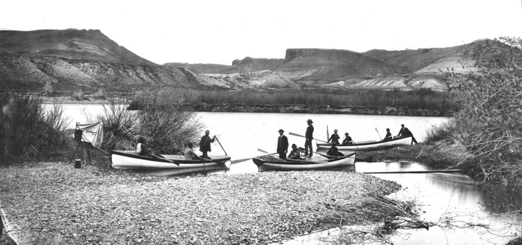
This photograph is of Powell’s 2nd expedition in 1871-2, but he squished both expeditions together in his published journals, so this is somewhat fitting.

Today marks the 150th anniversary of John Wesley Powell’s 1869 expedition down the Green and Colorado rivers from the town of Green River, Wyoming to the confluence of the Colorado and the Virgin on the downstream end of the Grand Canyon. The sesquicentennial of this journey of more than 900 miles into what Powell called “the Great Unknown” has, in the year leading up to today, garnered attention from water wonks, whitewater boaters, scholars, and casual observers, and it will undoubtedly continue to do so over the course of this year—and rightly so. Already, Powell’s journey has spawned op-eds, books, and replica journeys (albeit, undertaken with modern rubber boats rather than the ill-suited wooden boats Powell commissioned), all of which is unsurprising and even fitting given the larger-than-life status Powell has come to inhabit in the minds of conservationists, Western water stakeholders, and those of us who occasionally like to run the rapids of the Colorado River Basin.

Anniversaries—particularly one as significant as 150 years—provide a ready-made opportunity to celebrate and remember individuals, their actions, and their legacies. But in commemorating Powell, his expedition, and his contrarian vision of Western settlement that grew out of his firsthand experience in the Colorado Basin, we’ve missed an opportunity to reflect critically on the American response to and memory of Powell over the past century and a half. Rather than unquestioningly celebrating Powell and his legacy, this year gives us the chance to think about a couple of points:

  • First, how are we telling Powell’s story now, and how have we told it in the past? Is it, and has it been, accurate and useful?
  • Second, whose stories have we excluded, ignored, and forgotten about in the focus on Powell?

When we start to answer these questions, the sesquicentennial of Powell’s journey becomes an opportunity to explore new and different ways of thinking about the Colorado River and Western water.

I will be the last person to say that Powell wasn’t a deeply impressive person who provides us twenty-first-century dwellers ample fodder for celebration of his legacy. He planned, funded, staffed, and executed (on a shoestring budget) a months-long expedition into a region unknown to Euro-Americans. In perhaps his most oft-quoted passage, Powell captured this sense of looking past the edge of the known world: “We have an unknown distance yet to run, an unknown river to explore. What falls there are, we know not; what rocks beset the channel, we know not; what walls rise over the river, we know not. Ah, well! We may conjecture many things.” To make this feat even more impressive, Powell had only one arm. He was a disabled military veteran, having lost his right arm at the elbow after a Confederate minié ball shattered his wrist at the Battle of Shiloh.

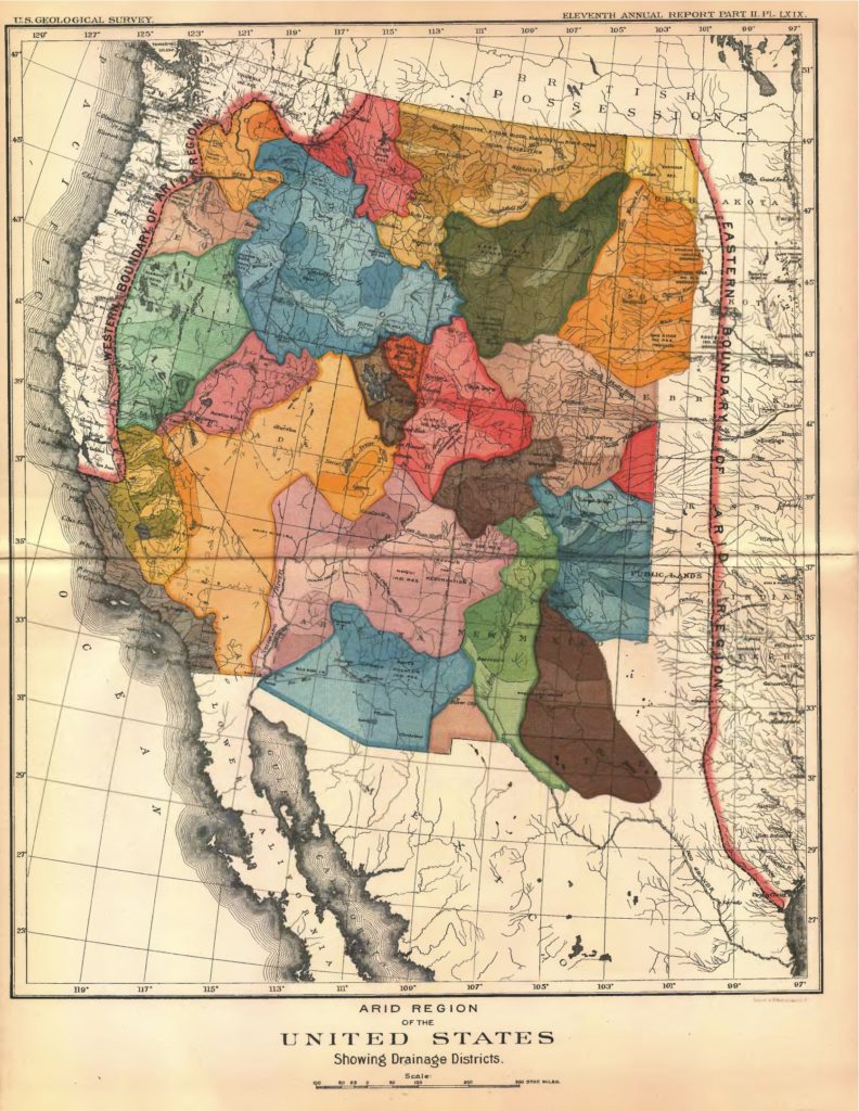
Powell’s legacy may have been fairly well assured had he returned to teaching college courses on natural history upon his return from the Colorado, but he did not rest on his laurels. Instead, he became a bureaucrat in the nation’s capital, where he pushed back against the boosterism of his day that promoted the West as a limitless and idyllic Eden where “rain follows the plow” and settlers would find easy success. Based on his experience in the “Arid Region,” Powell advocated caution instead of a headlong rush to populate the West, arguing that the region couldn’t sustain the population boosters advertised because of its climate. This debate produced what is probably the single most recognizable image in Western water history—Powell’s map of Western states drawn by watershed—and cemented his legacy as a progressive thinker who understood the concept of environmental limits.


Yes, these are reasons to celebrate Powell. But remembering him in this way has created its own set of problems.

First is the celebration of Powell’s journey into the “unknown.” Unknown, one might ask, to whom? Certainly the Indigenous people of the region knew the river and its environs intimately—it was unknown only from a Euro-American perspective.

Second, focusing on Powell also creates an image of the nineteenth century Colorado River from the viewpoint of a white, male, colonial character, a perspective that has persisted throughout the twentieth century and is only beginning to change (haltingly) in the twenty-first.

Third, the mythic proportions Powell’s battle against the boosters has taken on makes it the origin story for a history of Western water defined by conflict—the un-usefulness of which I don’t have to explain if you’re reading John Fleck’s blog. Finally, because Powell provides such an epic and charismatic figure, his viewpoints and actions are too often misremembered, distorted, and molded to fit the present day. See my review of a recent book about Powell for further discussion of the problems of presentism and inaccuracy.

So what have we missed in focusing on Powell? He is, it must be said, yet another dead white guy who’s been lionized in the intervening 150 years. Whose stories have we ignored in retelling his over and over? At the top of my list are the stories of the Indigenous peoples of the Basin. Yes, Powell was also an ethnographer and worked to record tribal customs and language—but only because he thought it inevitable that they would die out in the face of Anglo advancement into the West. What would an Indigenous history of the Basin look like? In this vein, what about a women’s history of the Basin, or a history of race and water? Westerners, those of us involved in water, in particular, are storytellers. Let’s tell better, more accurate, and more helpful stories that can help welcome a more diverse range of stakeholders to the table (while acknowledging they’ve been present the whole time), and that can encourage a larger portion of the population to see themselves in the history of how the Colorado came to be what it is today.

To this end, my colleague Dr. Adrianne Kroepsch, at the Colorado School of Mines, and I have started a Google Doc to build a better, more diverse repository of sources for Colorado River Basin history. Please feel free to browse, add to, and share the document, available publicly at this link: https://docs.google.com/spreadsheets/d/1P2Bcg-xzNi8GgmDuSdIZfPGM9CACJSyLGTEE7N7WKIs/edit?usp=sharing

What the Colorado River Drought Contingency Plan means in practice

Correction appended, I was off by 5kaf on the Nevada numbers, also fixed a badly garbled sentence, thanks to the alert reader who brought this to my attention

With the backdrop of Hoover Dam, an assembly of Colorado River dignitaries signed the Drought Contingency plan yesterday afternoon.


Now that we have a DCP, what does this mean in practice?

According to the most recent Bureau of Reclamation 24-month study, Lake Mead is projected to end 2019 at elevation ~1,085 feet above sea level. Prior to the DCP, Lower Basin water users (Mexico, Arizona, Nevada, California) got a full allocation of water as long as Lake Mead’s elevation was above 1,075. Under the DCP, a new shortage tier has been added between elevations 1,090 and 1,075. The result is that, for the first time in the history of Colorado River management, there will now be mandatory water use reductions on the Colorado River.

What does this mean in practice? I ran down a quick summary this morning of the relevant data, comparing recent use with the cuts mandated under the DCP. It shows that, at this first tier of shortage, permitted use is mandatory reductions are less than the voluntary cuts water users have been making since 2015:

in millions of acre feet Arizona Nevada California total
2015-2019 average, without DCP 2.578 0.242 4.234 7.054
2020 permitted, with DCP 2.608 0.292 4.4 7.3

In other words, all of the states are already using less water than contemplated in this first tier of DCP reductions.

The details, by state:

Arizona

Arizona’s full allocation is 2.8 million acre feet of water per year. In this new first year of shortage, Arizona will only be allowed to take 2.608 million acre feet of water, a 192,000 foot reduction.

This year, without any DCP, Arizona plans to voluntarily take larger reductions. The current forecast puts Arizona’s 2019 draw on the river at 2.515 million acre feet. Last year, Arizona took 2.639 million acre feet, according to the Bureau of Reclamation’s preliminary year-end accounting.

Here’s a summary of recent years:

Arizona Without DCP:

  • 2015: 2.601 maf
  • 2016: 2.613 maf
  • 2017: 2.510 maf
  • 2018: 2.640 maf
  • 2019: 2.515 maf

Arizona with DCP:

  • 2020: 2.608 maf

Nevada

Nevada’s full allocation is 300,000 acre feet of water per year. In this new first tier of shortage, Nevada will only be allowed to take 287,000 acre feet of water.

This year, without any DCP, Nevada plans to voluntarily take larger reductions. The current forecast puts Nevada’s 2019 draw on the river at 263,000 acre feet, but because of the way the forecasting is done, that will almost certainly go down. Last year, Nevada took 244,000 acre feet of water.

Nevada without DCP:

  • 2015: 220 kaf
  • 2016: 238 kaf
  • 2017: 243 kaf
  • 2018: 244 kaf
  • 2019: 263 kaf (but likely to drop)

Nevada with DCP:

  • 2020: 292 kaf

California

California’s full allocation is 4.4 million acre feet of water per year. California takes no cuts in this first tier of shortage

This year, California plans to take significant voluntary reductions. The current forecast puts California’s 2019 draw on the river at 4.064 million acre feet. Last year, California took 4.253 million acre feet of water.

California without DCP:

  • 2015: 4.494 maf
  • 2016: 4.381 maf
  • 2017: 4.026 maf
  • 2018: 4.253 maf
  • 2019: 4.064 maf

California with DCP:

  • 2020: 4.4 maf


“Fence Lake, you will some day fade away.”

Fence Lake, New Mexico. May, 2019, photo by John Fleck

On New Mexico Highway 36, beneath the sign announcing your entry into the community of Fence Lake, someone has appended a small hand-lettered sign announcing, “NO FISHING”. This is appropriate, as there is no lake.

Fence Lake is remarkably self-aware. There’s an obelisk-ish monument in front of the former Fence Lake school (now a “community center”) with these words:

This marker will remain to honor those people who first came, those who left, those who stayed and those who returned. Fence Lake, you will some day fade away. Until then, this serves as a remembrance of the heart, soul and spirit of those who passed this way.

The fading seems well underway.

The Institutional Hydrograh: Article VII of the Rio Grande Compact

If you’re following flows on the Rio Grande through New Mexico this spring, no doubt you noticed the big drop this morning in releases from El Vado Reservoir on the Rio Chama. (Of course you noticed, right?)

Welcome to what we in the UNM Water Resources Program have come to call “the institutional hydrograph”. It is when the rule, not the climate, becomes the dominant variable influencing flow in a river. It happens all the time.

Up until this morning, inflows and outflows from El Vado Reservoir were roughly in balance. The La Puente gauge, seen in brown, is the inflow. The green line is releases from the dam. You’ve got a nice diurnal cycle at La Puente, which the dam smooths out, but basically whatever water flowed in was simply being passed through the dam.

Rio Chama flows

The river is operated this way because of Article VII of the Rio Grande Compact:

Neither Colorado nor New Mexico shall increase the amount of water in storage in reservoirs constructed after 1929 whenever there is less than 400,000 acre feet of usable water in project storage….

“Usable water in project storage” is, roughly speaking, the amount of water sitting in Elephant Butte Reservoir. “Reservoirs constructed after 1929” includes El Vado and Caballo Reservoirs. Basically this means that when Elephant Butte is empty, we (Colorado and New Mexico) can’t store water upstream, we have to send it all down to Elephant Butte. The accounting rules here can get a bit arcane, but over the weekend “usable water in project storage” topped 400,000 acre feet, so – boom! – we can start storing water in El Vado, cutting flows on the Rio Chama instantly.

There’s so much water piled up at the next reservoir downstream, Abiquiu, that the cut in Chama flows shouldn’t be seen here in Albuquerque, where the river has been edging out to the levees with some of the highest flows in years. And there’s so much snow still in the upper elevations in the headwaters that this will be going on for a while.

So if you’re in Albuquerque, head out to the river, early and often. It’s an amazing sight.

Rio Grande, overbanking into the bosque, Albuquerque, New Mexico, May 12, 2019

Mo Hobbs on the interdisciplinary nature of water

“My research integrates elements of biology, hydrology, and geomorphology,” said Hobbs, who is currently working on her Masters’ in Water Resources in UNM’s Water Resources Program. “In New Mexico, the water is more spoken for than it is present. The use of water must be allocated amongst multiple users while also trying to maintain a life for aquatic organisms and habitats.”

Monika “Mo” Hobbs on her work on the Rio Chama., capturing, in a better nutshell than I’ve ever seen, what our program is all about.

I love our students.

When you cross a bridge, look down

on a bridge, looking down

When you cross a bridge, Craig Childs said at an American Rivers gathering in Santa Fe Friday evening, stop, and look down.

A couple of llamas stared in what I imagine was puzzlement this morning as I dropped my bike and walked out onto the planks bridging one of the irrigation ditches in Albuquerque’s South Valley. Today is my 60th birthday, and I took a long morning bike ride that (metaphor alert) included a lot of stopping on bridges and looking down.

for example, a llama pasture

This is a common feature of the valley ditches – a control structure that can be used to raise the water level to reach irrigation turnouts to divert water into, for example, a llama pasture. This particular ditch is nameless to me, part of the complex system through which the Rio Grande splays out across Albuquerque’s valley floor to irrigate, for example, llama pastures.

Sitting on a panel next to Craig Friday was humbling and a little intimidating. When I was first starting to write what became Water is For Fighting Over, floundering to find a voice, I visited Mesa, Arizona, and this 2007 High Country News Piece of Craig’s:

Phoenix seems either on the verge of unparalleled success or catastrophic failure. At this point, it might be hard to tell the difference between the two.

On Mesa’s mesa you can see the remnants of old Hohokam canals, and I lingered at a modern water drop from one of the Salt River Project concrete behemoths into some of the remnant citrus groves up against the now-mostly-dry Salt River’s bed.

What was quite literally the first draft I wrote was voiced in response to Craig’s piece, and I set out to try to answer the question he had posed – about Phoenix and all of the West. Which are we on the verge of?

I am not the poet, my gifts if I have them more technocratic. As I carried out Craig’s advice this morning (“When you cross a bridge, stop, and look down….”), I tried to smell the river. (“My earliest memory is the smell of water in the desert,” Childs has written.) I feel prosaic and not at all the poet I imagined I would become when, as a substitute for smell, I stand on the Central Avenue Bridge and look up the Rio Grande’s flow on my iPhone. (5,050 cubic feet per second, the highest flow on my birthday since 1993.)

But as I cross over into my 61st year (metaphor alert) I am comfortable with what I see beneath the bridge, the voice I have finally found.


Fishing the ditches

I had a fascinating conversation this morning with the guy in the hat, who was out with his family fishing where the Middle Rio Grand Conservancy District’s Central Wasteway drops water out of the Albuquerque irrigation system, back into the Rio Grande.

Fishing the Central Wasteway

I’ve been bicycling to this bridge three or four times a week recently, because it’s one of the best places to watch the changes in the rising Rio Grande. With a big snowmelt building, we’re seeing some of the highest flows in years, and I’m missing none of it.

I’ve been talking to our UNM Water Resources students about a cormorant I’ve seen off the bridge, fishing at the confluence between irrigation system and river – a boundary between nature and not nature. Perhaps. Today was the first time I’ve seen humans fishing there. Apparently it’s a good place for fish.

The guy in the hat gave me a marvelous rundown of the best places to fish in the MRGCD ditches. I didn’t have anything to take notes (Note to Fleck: carry the damn notebook when you’re riding!), but I do recall that one of the best fishing spots in the valley is the ditch behind the Walmart at Dennis Chavez and Coors in the South Valley. I remembered this particularity because my friend Scot lives across the alfalfa fields (one of the valley’s last big farmed patches) from Walmart.

Apparently if he was so inclined, Scot could fish out the ditch behind his house, as well as irrigate.

The cormorant fishing off the bridge is interesting. In the decade or so I’ve been birding the riverside woods, I’ve noted an increase in the number of cormorants. I hypothesize that they’ve been drawn by the stocked fishing ponds a mile to the south, and are now spreading out to the river.

“Nature,” writes Robert Macfarlane in the delightful Landmarks, which my sister, Lisa, gave me for my birthday, “is not now, nor has ever been, a pure category. We inhabit a post-pastoral terrain, full of compromise and modification.”

I think one of the fish the guy in the hat told me about was carp.

Adam Smith on the value of water

The word value, it is to be observed, has two different meanings, and sometimes expresses the utility of some particular object, and sometimes the power of purchasing other goods which the possession of that object conveys. The one may be called value in use; the other, value in exchange. The things which have the greatest value in use have frequently little or no value in exchange; and, on the contrary, those which have the greatest value in exchange have frequently little or no value in use. Nothing is more useful than water; but it will purchase scarce anything; scarce anything can be had in exchange for it. A diamond, on the contrary, has scarce any value in use; but a very great quantity of other goods may frequently be had in exchange for it.

Adam Smith, Wealth of Nations

Central Arizona ag’s decline continues, but Pinal County is up

In the wake of Arizona’s difficulties in coming to terms with the future of central Arizona agriculture as it sorted out its approach to reducing Colorado River water use under the Drought Contingency Plan, the latest Census of Agriculture data is fascinating.

Irrigated agriculture in the Central Arizona Project counties

The decline continues, but only just barely. The data within this data, broken out by county, is fascinating:

Central Arizona irrigated acreage, by county

Pinal County agriculture, with receives heavily subsidized irrigation water via the Central Arizona Project, has actually been expanding since the 1980s, according to the Census of Agriculture.

New Mexico’s Rio Grande, rising

My co-author Eric Kuhn was in town over the weekend to finish up the copy edits for our upcoming book Science be Dammed, and happily we were not so busy that we didn’t have a chance to get in a couple of bike rides. (In our collaboration these last few years, “Are you going to bring a bike?” or “Should I bring a helmet?” have played an valuable role.)

Eric Kuhn at the Rio Grande, Albuquerque, New Mexico, April 2019

We got rides out to Albuquerque’s Rio Grande both Saturday and Sunday, and with the river rising in response to our big snowmelt, we started to see some “overbanking” in channels build by environmental engineers to mimic the old flood plain flows this valley used to see.

I am obsessed, and have been getting out lately nearly ever day (one has to ride one’s bike somewhere, right?) to see the river rise. Here, for those in Albuquerque who want to enjoy the obsession along with me, is a map to a couple of my favorite spots right now:


Both are easily accessible via the city open space trail that starts at the parking and picnic area on the north/east side of the river just upstream from the Central Avenue Bridge.