I Miss My Students

When I emerged from my office at home after recording my first university lecture of the pandemic era, Lissa told me I’d been using my radio voice.

As a young journalist – before newspapers, before books, before my crazy new career as a university professor – I did radio. It’s been nearly forty years, but even now when I slip into a public communication mode, I drop into what Lissa calls my “radio voice”. So without thinking, sitting at a computer in my home office talking to students disembodied in both time and space, I went there.

So OK, I guess that’s the way I’ll have to think of this task. I’m doing radio.

But I still hate it.

I am super sad.

I miss my students.

tacos in the time of pandemic

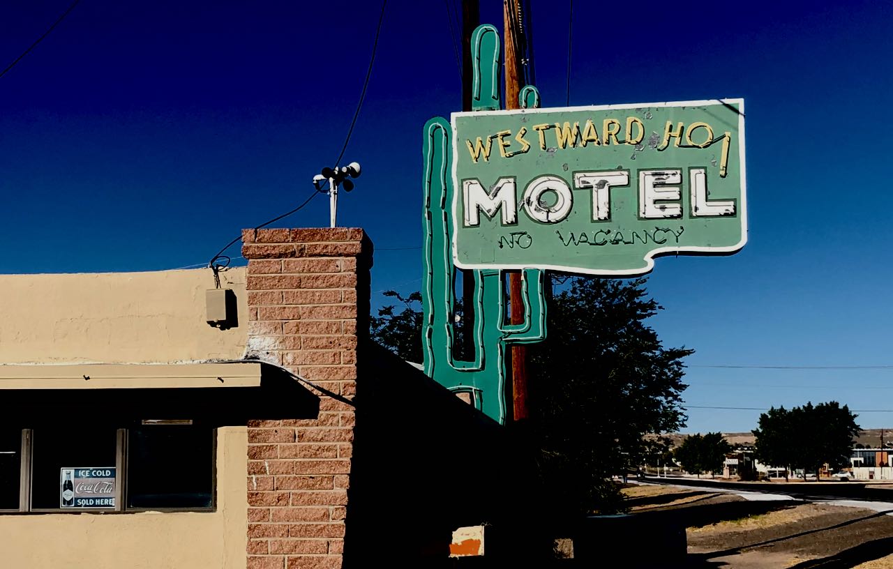
Westward Ho

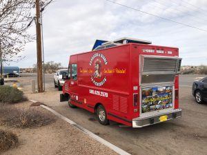
In retrospect, the red taco truck represents the moment it all changed.

a red taco truck

Taco truck, Albuquerque, New Mexico, March 2020

It was parked along Central, old Route 66, on Albuquerque’s west side. My friend Scot and I, out for our Sunday bike ride, had been debating the wisdom of our usual bike ride brunch – tacos from one of our local market food counters.

We discussed best risk reduction practices. Maybe one of us should go in and get the tacos, to eat outside? Maybe we should skip the tacos entirely?

From the vantage point of our world circa March 15, 2020, skipping tacos was inconceivable.

And then, like an apparition, the fire engine red La Pichorrita appeared by the side of the road, a clump of cars pulled over helter skelter around it.

Our Sunday ride is always the high point of my week – hours of often aimless rambling, both in route, and conversation. There is time to double back to be sure we’ve covered everything – again, both in route, and conversation. On this particular Sunday it seemed desperately important to engage in idle conversation and idle wandering.

a poor substitute for tacos

This stretch of West Central is not exactly scenic in conventional terms – old Route 66 motels (the “French Quarter” across the street from where we got our tacos, and the wonderfully named “Westward Ho” just down the way). But it’s Albuquerque in a way that we love.

Our discussion after pulling over to the taco truck seems, from today’s vantage point, a vast ten days later, quaint. One of us would order, while the other stayed back, away from the other people also waiting for their tacos. All stood awkwardly, or waited in their cars, as the first responders of barbacoa made our brunch. We took our tacos and sat on a concrete curb in front of a Penske truck rental place. They were delicious.

The ride that day went on forever, down South Valley ditchbanks until we could ride south no more. We didn’t want to turn around.

I’m still riding every day. It remains a mental health anchor. But that was the last ride with Scot for a while, and the last ride with tacos.

On my desperate trip to the supermarket to stock up (we all did that in those early days, didn’t we?) I stood impatiently in the breakfast bar aisle, hurriedly looking at labels to see which bars could serve as a pocketable caloric substitute for tacos.

I am now the owner of several months’ supply of peanut butter and dark chocolate chewy protein bars. They’ll do, but I refuse to learn to enjoy them.


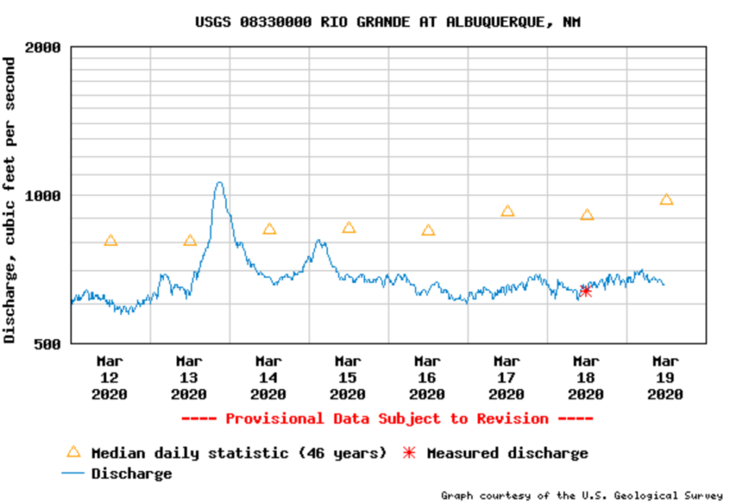
Stream gaging in the time of pandemic, Episode II

From the comments, DG elaborates on the task of stream gaging

And I can see our intrepid hydrotech out on a walkway at the ‘gage’ (thanks for that), laptop in hand. He’s cabled up to a Data Logger dumping the collected data that had accumulated since his last visit to the site some 4 to 6 weeks ago. He also checks the calibration of a Shaft Encoder a Pressure Probe or Bubbler. Any of these sensing elements needing some form of recalibration (they all drift to some degree). It’s windy and cold on the walkway but that doesn’t hinder our technician. As the log dumps into the laptop, he checks the site battery and the solar panel for the ever present bird droppings that accumulate on such an appealing perch. He mutters to himself that he’s sure glad that the avian flu is not his enemy this time around. Oh my? What is this? The mice have gotten back inside of the gage and have left their calling cards behind. The Gager rememberers a few years back about warnings of the Plague and the mice. Every Field Tech in the Southwest had heard about that and kept mice out of their beloved gages. He quickly gets a mask on, sprays over the soiled area and cleans the area to where it’s cleaner than an operating room. The mask, his gloves and soiled towels sealed tightly in a plastic bag.

Of course he muses to himself that working alone at this remote gage is the ideal example of Social Distancing. Nobody comes out to the gage on a cold and windy day. He would be in more peril back in the office next to hydrotech Johnson who is currently wheezing away…

How Dry was 2000-2018 on the Colorado Compared to “Normal”?

By Eric Kuhn

The Colorado River’s natural flows are shrinking by 9% per degree C (1.8 F) of warming as climate change continues to sap the river’s flow, according to an important new study by Chris Milly and Krista Dunne of the US Geological Survey. Milly and Dunne also conclude that increasing precipitation is unlikely to offset this temperature induced drying. The study adds important additional evidence that not only will climate change reduce the river’s flows in the future, but that it is already happening – the already over-tapped Colorado River is facing a future with even less water.

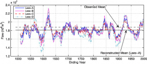
tree ring reconstruction of the Colorado River’s flow, from Woodhouse, Connie A., Stephen T. Gray, and David M. Meko. “Updated streamflow reconstructions for the Upper Colorado River basin.” Water Resources Research 42.5 (2006).

My one caution is that like almost all other similar studies, for baseline purposes, Milly and Dunne use the Colorado River Natural Flow Data Base (NFDB) for the annual natural flows at Lee Ferry.  The Natural Flow Data Base is maintained by Bureau of Reclamation scientists based at CADSWES in Boulder, Colorado. The data base shows monthly and annual natural flows at critical points in the basin including Lees Ferry. It is updated approximately annually when the most recent year for which data are available is added.  The most recent version was released in February 2020 and covers water years 1906-1918.  The version used by Milly and Dunne was released in March 2019 covering 1906-2017.

While the Natural Flow Data Base provided an important source of baseline information for Milly and Dunne, as well as other recent studies of the impact of climate change on the Colorado River, it is important to be aware of its shortcomings.

Uncertainty about early data

The farther we go back in time, the less confidence we should have in the data.  Natural flows are gauged flows adjusted for upstream human hydrologic modifications. Before 1930 there were relatively few gauging stations in the entire basin and before June 1921 there was no gauge at the critical Lees Ferry location (Water Year 1922 is the first full year of measured flows at Lees Ferry). The major sources of consumptive use above Lees Ferry are irrigated agriculture (well over 90% of the use before the major dams and export projects were built beginning in the 1950s). Irrigation uses are the most critical variables used to calculate the natural flows reported in the NFDB, but before the late 1940s the data available on acres under irrigation and cropping types were very sparse. The major source of data was the federal irrigation census conducted every five to ten years. Beginning in the late 1940s, project planning efforts by the Bureau of Reclamation led to much more and better data on irrigation use.

Start date

Although the NFDB begins with Water Year 1906, both the Bureau of Reclamation and USGS published data sets with estimated annual natural flows at Lees Ferry starting well before 1906. In Science Be Dammed John Fleck and I make the case that 1906 was likely picked in the 1960s by Commissioner Floyd Dominy to give the Central Arizona Project the best water yield (read the book). It is a decision we live with today. Before the 1960s, Reclamation studies routinely used natural flows back into the 1890s. There are annual natural flow estimates for Lee Ferry of comparable quality to the pre-Lees Ferry gauge estimates that go back to about 1878.  Why is this important? The early 20th Century pluvial began in 1905/06 and lasted through about 1930. In the three decades before 1905 conditions in the Colorado River basin were much drier, similar to the Colorado River Basin in the 1930s to 50s (thus Dominy’s marketing decision). The choice one makes about which period of record to use makes a difference in how the river’s estimated mean annual flow:

  • 1906-2018: 14.8 million acre-feet per year (MAF/yr).
  • 1878-2018: 14.4 MAF/yr.

Based on tree-ring based reconstructions we now understand that the 1906-30 pluvial was not only wet, it was extraordinarily wet. In an observation first made by Charles Stockton and Gordon Jacoby in their seminal 1976 paper reconstructing Lee Ferry Flows back over 400 years, they conclude that the periods of record used by the Bureau of Reclamation that include the 1906-30 pluvial will be skewed to the wet-side. Based on more recent reconstructions, we now believe that 1906-30 was one of the two or three wettest 25-year periods in the last 1400 years (perhaps even the wettest). The long-term average natural flow at Lees Ferry from the most recent reconstructions (Treeflow.info 2018) is about 14.3 MAF/yr.

Implications of the data’s shortcomings

What are the implications of the cautions I’ve listed?  For starters, when comparing the recent 2000-2018 “drought” period with periods of record that begin with or include major portions of the 1906-30 pluvial, the magnitude of the current “drought” is often overstated.

Based on the NFDB, the mean annual natural flow at Lees Ferry for 2000-2018 was 12.47 MAF/yr, 15.5% less than the 1906-2018 average of 14.76 MAF/yr (“normal”).  However, using a different baseline such as the post-pluvial period of 1931 -2018, that same drought period is only 10% less than “normal”. Given the uncertainties in the natural flow data base before 1930, the use 1931-2018 is a reasonable decision (and one that is gaining favor with some of the basin’s water agencies).

For research purposes, study authors might want to give more consideration to the uncertainties in the NFDB. They should consider using a periods of record starting in 1922, after there was an actual gauge at Lees Ferry, or 1931, the post pluvial period and the year after the Boulder Canyon Project Act funded additional gauging stations, or even 1948, the year soil scientists, Blaney and Criddle, were tasked with improving our understanding of irrigation consumptive uses in the Upper Basin. If possible, study authors may even want to compare their results with the long-term paleo record mean of 14.3 MAF/yr. All are reasonable approaches that will yield slightly different results.  As with Milly and Dunne, for many studies, the period of record used may be driven by other data limitations.

The bottom line is that there are a range of different answers to the question of what is the normal flow of the Colorado River at Lees Ferry. Milly and Dunne, along with other researchers have used the Natural Flow Data Base to help us understand the impact of climate change on the Colorado River, have made critical contributions. But as we move forward with our policy responses, we need to be open about the uncertainties inherent in the data we are using. An effort to study the sensitivity of climate change analyses to the uncertainties in the NFDB would be a valuable addition to our understanding.

Could water from retiring coal plants help solve the Upper Colorado River Basin’s “demand management” problem?

By Eric Kuhn

As the states of the Upper Colorado River Basin work through how to build a “demand management” account in their reservoirs to protect against shortages, water from retiring coal plants could play a crucial role. With few alternatives for use of the water, simply banking it in Upper Basin reservoirs is an attractive option.

In a recent KUNC piece, Luke Runyan discussed the impact of Tri-State G & T’s decision to close its coal-fired power plant near Craig, Colorado. Luke focused on the impact of the closing on the local community and options for the water rights that will be freed up when the plant is closed.  The Craig Station is one of ten major coal-fired power stations that were built in the Upper Colorado River Basin from the mid-1960s through the early 1980s. Several smaller plants were also built in the 50s, now all shut down. These plants were spaced throughout the basin with three in Utah, two each in Colorado, Wyoming, and New Mexico, and one in Arizona’s small portion of the Upper Basin, the Navajo Generating Station near Page, AZ.

For many reasons – their age (most are approaching their design life), high operational costs, and the need to reduce carbon emissions – these plants are being de-commissioned.  In 2014, three of the five units of the San Juan Plant in Northwestern New Mexico were shuttered followed by two of the four units of the neighboring Four Corners Plant in 2017. Last year, the Navajo Generating Station produced its last power and Tri-State made the decision to completely close the Craig Station by 2030. Further, last year the owners of the remaining operational units of the Four Corners and San Juan Plants in New Mexico and the Naughton and Bridger Plants in Wyoming made it clear that each will be shut down sometime in the next decade or so. By the early 2030s it’s likely that there will be no operating coal plants in the Upper Basin (the possible exception being one of the plants in Utah).  This raises the question explored by Luke Runyon. What will happen to the water that these plants were once consuming?

The source of cooling water for all these plants is the Upper Colorado River or one of its tributaries.  According to the Bureau of Reclamation’s Consumptive Uses and Losses Report, their 1991-2018 annual consumption averaged 162,000 acre-feet per year. At the peak in 2006, these plants were collectively consuming over 170,000 acre-feet of the Upper Basin’s compact share.  In 2018, it had fallen to 144,000 acre-feet. Recognizing that the total consumptive use in the Upper Basin is a bit over four million acre-feet per year (not counting CRSP reservoir evaporation), a reduction of 4% may not seem like a big deal, but a closer look suggests that it could be very significant.

Upper Basin use

First, the Upper Basin’s total annual consumptives use have been flat since the late 1980s (see this nice analysis by Jian Wang and David Rosenberg at Utah State). The reasons are simple. The last major irrigation and export projects (trans-mountain diversions) were largely completed by the mid-1980s.  Except for the Lake Powell Pipeline (which may not be considered an Upper Basin use under the compact), there are no serious proposals for new export or irrigation projects (Denver Water’s Moffat Expansion and Northern Water’s Windy Gap Firming Project are tweaks to existing projects). Some have suggested the plant water could be sold or made available to existing export or irrigation projects. That is very unlikely. The diversion points for the existing trans-mountain diversions are far from the locations of these plants. Moving plant water to the Continental or Great Basin Divides would be very expensive.  The non-use of the plant water rights could in some years benefit existing irrigation supplies, but for the most part irrigation users already have senior rights and the irrigation of new lands would require large new public subsidies, an unlikely event. Further, much of the internal municipal growth within the Upper Basin is displacing existing irrigated agriculture where the net change in consumptive use is small or even negative.  Since it’s subject to the vagaries of regional precipitation and water supply conditions in adjacent basins such as the South Platte where water is exported to, consumptive uses in the Upper Basin will continue to be variable on a year-to-year basis, but it is clear that the loss of 160,000 acre-feet of consumptive use over the next decade will be measurable and will likely contribute to a downward trend.

Second, 160,000 acre-feet of consumptive use per year is actually a lot of water.  Only a few of the Upper Basin’s largest projects, the C-BT and Uncompahgre Projects for example, consume more. Water efficient cities such as Las Vegas or Phoenix could serve more than 1.5 million people with this amount of water. It’s over half of Nevada’s use from Lake Mead and close to half of the average annual use of the upper states of New Mexico and Wyoming.  Between equalization releases (the last one was 2011), Lake Powell has “memory.” It stores every extra acre-foot of inflow. Without the coal plant use, an additional 1.4 million acre-feet of post-2011 water would be in storage there today.

Finally, for the implementation of the drought contingency plans (DCPs), 160,000 acre-feet of water could be a very useful and significant asset.  The States of the Upper Division are currently studying the implementation of demand management. The federal legislation approving the DCPs gives these states access to 500,000 acre-feet of Lake Powell storage space.  A strategy to fill this space with 100,000 acre-feet of conserved consumptive use per year (primarily from existing agriculture) over five years would be a huge political challenge and cost $25 million per year or more.  The 160,000 acre-feet of unused plant water would fill that same space in about three years.  The challenges for the upper states will be first to take a realistic look at their future demands and factor in both the upward and downward trends, and to figure out how to incorporate these plant closures into their post-2026 river management strategy.  If they can’t, gravity will ensure that the Lower Basin is the ultimate water beneficiary of the closing of these plants.


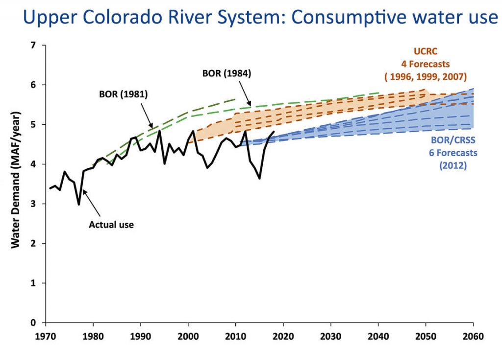
We keep projecting that water use will go up. We keep mostly being wrong.

Jian Wang and David E. Rosenberg at Utah State have put together an incredibly helpful compilation of past projections of Upper Colorado River Basin consumptive use, as compared to what then actually happened:

When averaged over the long term, each scenario of future consumptive use over-estimated the observed consumptive use.

Upper Basin use

Herein lies the space for problem solving.

Robert Moses, the Colorado River, and the tragedy of the anticommons

[T]he anticommons refers to situations where there are numerous overlapping rights holders (or what might also be seen as numerous policy advocacy coalitions) each with some power to veto or block system or operation change. The tragedy emerges when the composite effect of such power prevents significant change in the system.

– Jones, Benjamin A., et al. “Valuation in the anthropocene: exploring options for alternative operations of the Glen Canyon Dam.” Water Resources and Economics 14 (2016)

Wandering the halls of Bally’s in Las Vegas last December, at the annual meeting of the Colorado River Water Users Association, I received a text from a friend with a link to a piece in Politico by Marc Dunkelman about the late New York power broker Robert Moses.

Robert Moses turning models into a reshaped city. Library of Congress. New York World-Telegram & Sun Collection. http://hdl.loc.gov/loc.pnp/cph.3c36079

Dunkelman spins a wonderfully readable tale of New York’s Penn Station, in particular why it is so awful. Because despite everyone knowing this central Manhattan transportation hub needs to be fixed, and lots of people having good ideas about how to do it, and projects to carry them out, Penn Station remains awful:

In a dynamic where so many players can exercise a veto, it’s nearly impossible to move a project forward. No one today has the leverage to do what seems to be best for New York as a whole.

When I bumped into my friend later that day at Bally’s, I shared my puzzlement. Why was I being encouraged to read about Moses and Penn Station?

I have long argued that a robust governance network, both formal and informal, around the management of the Colorado River provides the necessary conditions for managing the problems of the river’s overallocation and the increasingly apparent impacts of climate change. That’s the argument at the heart of my last book, Water is For Fighting Over: And Other Myths About Water in the West

But as we approach the negotiation of the next set of Colorado River management rules – a process already bubbling in the background – it is not hard to see how my thesis could break down. The problem is an institutional structure that has distributed veto power across the Colorado River Basin.

I’ve been thinking a lot about my friend’s “read about Moses” tip in the months since CRWUA.

Moses, the “master builder” of modern New York who famously ran roughshod over – well, over everyone who didn’t agree with his sometimes troubling vision – left in his wake a reaction against such concentrations of power.

The progressive movement that arose in opposition created mechanisms to prevent another Moses from doing Mosesy things. Decades later, as Dunkelman documents, the veto points created to accomplish this reining in of power have made it impossible to fix Penn Station. While everyone agrees that the fixing is needed, lots of people disagree with the specifics of any one proposed fixed. And those people have a veto. So the fixing never gets done.

We have a similar problem in the Colorado River Basin. The river’s water allocation schemes are broken. Eric Kuhn and I spent a good deal of time laying out how that brokenness came about in our new book Science Be Dammed. We spent some time sticking our necks out with some of our ideas about what fixing it might look like. But as the discussions about a new river management ruleset bubble away, it is clear that we’ve got a problem very much like post-Moses New York: lots of people have a veto over any new scheme that we or anyone else might cook up.

The origins of the problem, in New York versus the Colorado River Basin, seem different. Where in New York the distribution of veto power arose in response to harms at Moses’s hands, in the Colorado River Basin the problems were baked in at the start. A federalism that left water management to individual states, combined with a compact that effectively gives each of the seven basin states (and, I guess, the federal government, and probably Mexico, and maybe going forward 29 sovereign Tribal nations, and increasingly an effective environmental community) a veto over any potential fix leaves us with a Penn Station-like gridlock. Here’s how I described the problem five years ago:

The first time I wrote about Terry Fulp, a key manager with the Bureau of Reclamation, I described him as “the closest thing we have to a guy with his hand on the tap that controls the vast plumbing system built over the past century to distribute the Colorado’s waters.” But I have come to realize in the years since I published that line in 2009 that, in reality, no one has their hand on the tap, and nobody has the ability to turn it down. Instead, we’ve built a decentralized system with no one in charge.

When I wrote that, I don’t think I full grasped the corollary – not only is no one in charge, but lots of people have the power to block solutions they don’t like.

After a talk I gave about the new book last week at the University of New Mexico School of Law, a student asked me the obvious question: We don’t we simply proportionally reduce everyone’s allocation to match hydrologic reality?

This of course makes perfect sense. But it is impossible in a system where major parties have deeply held views about fairness and equity and why they should keep their full allocation while those other people in that other place, who have been far less responsible, suffer the burden of shortage. And where the institutional structures effectively give all those parties a veto over such a solution.

University of Michigan legal scholar Michael Heller slapped a wonderful label on the problem some years back – “The Tragedy of the Anticommons“. I’m bending Heller’s original case to apply it here. But the idea of the existence of multiple veto points over solutions to commonly shared problems seems to hold, here and in many many other cases. (There has been a great deal of bending of Heller’s original anticommons idea since he first published it – it’s a pretty rich conceptual framework.)

My University of New Mexico colleagues Bob Berrens and Benjamin Jones are among those who have written about this in the context of Colorado River management (it was Bob some years ago who turned me on to Heller and the “anticommons” literature – Bob and Benjamin were writing the paper I link to at the same time I was writing Water is For Fighting Over):

[T]he anticommons refers to situations where there are numerous overlapping rights holders (or what might also be seen as numerous policy advocacy coalitions) each with some power to veto or block system or operation change. The tragedy emerges when the composite effect of such power prevents significant change in the system, and suboptimal use of limited resources. Like the better-known tragedy of the commons, the tragedy of the anti-commons also represents a coordination problem.

Jones et al (Bob and Benjamin and colleagues) suggest a path forward:

Governance processes for finding pathways through such coordination problems (e.g., to system operation changes), may benefit from improved information about the full range of preferences held across a population and argued in the policy domain. For example, broader system perspectives are more likely to find flexible least-cost alternatives to operational changes.

I don’t have an ending here. I’m not sure where to go with this.

The solution so far has been a series of incremental fixes that have avoided the risk of veto-triggering disputes. Maybe this argues for more of that – more incrementalism, rather than the sort of “grand bargainy thing” some of us have been advocating.