From “The Great Mistake” to “Science Be Dammed”

William L. Sibert

William L. Sibert

When I was wrestling six years ago with a path through what became my book Water Is For Fighting Over, I collected material about what I came to call “the great mistake” – the overallocation of the Colorado River’s water. One of my favorite stories surrounded William Sibert:

It is quite probable that the compact attempts to apportion more water than the actual average undepleted flow of the river.

That’s circa 1928, before Congress ratified the Colorado River Compact and approved the construction of Hoover Dam, in a technical review of the project requested by Congress.

I set the topic aside back in 2013 in part because of the technical complexity of the early water math. I frankly had a hard time with the analytical framework (which period of record? which gauges? what upstream depletions? and on….), and the task of writing sensibly about something I couldn’t fully grasp myself was daunting.

Thanks to Eric Kuhn, who’d been thinking along the same lines and who had the analytical chops to make sense of what Sibert and others at the time were saying, we’ve had a chance to take another crack at “the great mistake”.

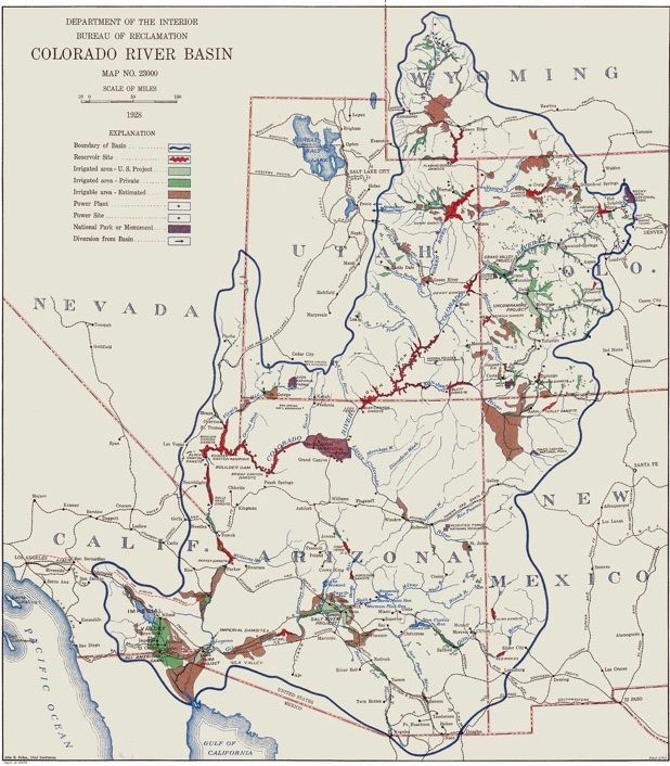
There in the pages of the Sibert board’s report was a clear message. The nineteenth-century droughts … meant the Colorado River had less water than the boosters had imagined when they crafted the 1922 Colorado River Compact and the federal legislation now before the Congress to ratify the compact and launch construction of what would become the Hoover Dam. The report’s math was inescapable. Once reservoir evaporation and water for Mexico were taken into consideration, any realistic effort to estimate the river’s flow left too little water to meet the allocations carved out in the 1922 compact and about to be ratified by Congress in federal statute.

That’s from “The Sibert Report: A Lost Opportunity”, Chapter 6 of our new book Science Be Dammed: How Ignoring Inconvenient Science Drained the Colorado River, out next month from the University of Arizona Press.

Sibert’s story is an important one that has been largely lost to history, relegated to footnotes or ignored entirely. A retired Army officer and engineer, he headed a panel chartered by Congress in 1928 to review the feasibility of the project about to be launched:

A board of engineers would be tasked with advising federal decision-makers on “matter affecting the safety, the economic and engineering feasibility, and adequacy of the proposed structure and incidental works” to be built on the Colorado River.

Critics of what would become Hoover Dam hoped to scuttle it on technical grounds – could they really build a dam that big? But Sibert, to his credit, took his charge of “economic feasibility” seriously. Would there be enough water to generate the electricity to pay for the project? That required him to take up the underlying question – does the Colorado River really have enough water to honor the allocations in the legislation Congress was about to approve?

His answer, quoted above, was “no”.

Water nerds in the audience will love Eric’s dissection of Sibert’s analysis of the river’s flows. (Buy our book!) More importantly, I hope water nerds in the audience will I hope appreciate Sibert’s probabilistic approach to water management:

Rather than picking one number, the board suggested the planning consider a range, with flows available for future depletion ranging from 10 million acre-feet during drought periods as long as 15–20 years, to high flows over similar time periods of 14.5 million acre-feet, with a long-term average somewhere in the middle.

As we explain in the book, there was too much momentum in Congress and the nation, and Sibert’s careful analysis was ignored. We live today with the consequences.


a dinosaur, in the fog

a dinosaur sculpture in the fog

a dinosaur in the fog, Albuquerque, New Mexico

Priorities.

Thrashing in a pile of work – a university program report that’s overdue, a book review (also overdue), two papers I’m writing with colleagues, a presentation for new grant funders to prepare, and a class to teach – I had plans for just a quick early morning bike ride this morning. But as my bike trail dropped down to Albuquerque’s valley floor, I saw the fog.

I have lived longer in Albuquerque than Southern California, the land of my birth. But Southern California came first. And so on those rare days when we have fog in Albuquerque, I am wistful, reminded of the magic of the fogs of my childhood. It encloses you gently, the fog, erasing things, telling you there are things you’ve no need to see, or know.

I headed out across the river, watching the Rio Grande disappear in the mist. Down back roads and dirt paths I’ve ridden a dozen times in daylight I became delightfully lost, more than once. My glasses fogged and I let them, the fog doing double work. As I dropped back down from the west mesa, toward the river again, the sun came close to burning through the fog, so I looked for the places it remained thickest and rode toward them.

When I was a teenager in the suburbs east of Los Angeles, we would drive to Chino, our valley’s low spot, when it still had dairies, was the place most likely to have fog. There was a story whispered from older brothers and sisters about the mystery of “the green mist”, and we weren’t quite what it was or why we were looking for it.

Just fog, I guess, but in retrospect that is probably enough.

Rio Grande in the fog, Albuqueruqe, New Mexico, October 2019

Rio Grande in the fog, Albuqueruqe, New Mexico, October 2019

Albuquerque’s water use continues to decline

The decoupling between water use and economic and population growth continues in Albuquerque, where we’ve cut per capita water use by more than half since the mid-1990s:

Albuquerque endured a hot, dry summer this year. Temperatures are still above average, and the monsoon season never made a big splash. But that hasn’t stopped the city from conserving water.

At its board meeting Wednesday, the Albuquerque Bernalillo County Water Utility Authority said customers, through Sept. 9, have used 812 million fewer gallons in 2019 compared with this same time last year. That equates to about 4 fewer gallons per person per day.

Not some magic bean thing going on here. The decoupling we’re seeing across the West, as water use declines even as populations grow, has become the norm. Here’s the aquifer beneath my house, rising:

USGS Del Sol Divider

More Colorado River “grand bargain” buzz

There was more buzz this week at two big Colorado River Basin events about the idea of a “grand bargain” to deal with coming collisions between water overallocation and the Law of the River.

The idea crept into the title of the Water Education Foundation’s 2019 Santa Fe Symposium – “Can We Build a Bridge to a Grand Bargain in the Basin?”. It  also came up repeatedly at the Colorado River Water Conservation District’s fall water seminar, including in a luncheon keynote by the University of Colorado’s Doug Kenney, who has done a lot of the analytical heavy lifting on the idea.

While most of the people yakking about it in public right now are folks unaffiliated with organized water interests (folks like, well, me), the interesting thing right now is the behind-the-scenes conversations among decision makers within the system. There’s been positive interest across geographic and water-using communities, including both Upper and Lower Basin folks, and both ag and municipal water users.

My collaborator Eric Kuhn, the former general manager of of the Colorado River Water Conservation District well known as a staunch defender of rural Colorado West Slope water interests, is in the middle of all this, speaking at both events. While the ideas has many parents, Eric has come to be identified with it in part because, now that he’s retired, he can thrown down a bit more than when he had the portfolio of obligations that comes with running an agency.

Eric’s 2012 white paper

The idea’s been kicking around for more than a decade, but it was in fact Eric who first publicly documented what to that point had been private discussions. In a widely read 2012 white paper (p. 41, pdf here), Eric detailed a conversation at a 2005 meeting of the basin states principles at a hotel here in Albuquerque. The details are arcane (click through for Eric’s explanation) but the idea is that each basin gives up politically treasured but practically unrealistic interpretations of the Law of the River in a compromise that avoids litigation and provides more certainty for the water management communities in both basins.

Doug Kenney and colleagues have done the most detailed analysis of the idea (see here), if you’re looking for details. But I caution not to focus too much right now on those details. What’s critical, as Eric and I write in our about-to-emerge-book, is that the process of discussion we’re now seeing among basin water users has a chance to bat around ideas, including beating up ours:

The process by which such a grand bargain might happen may be every bit as important as the technical details of what it would entail. At a 2005 meeting of the “basin states principles”—the Colorado River leadership team representing each of the seven basin states—representatives from Colorado floated a proposal. The details involved some tricky trade-offs. But the details are less important than the forum.

Such an agreement cannot be specified ahead of time but has to emerge from the process of collaboration and compromise that has grown up over the last two decades. That 2005 meeting is an example of the sort of meetings that happen all the time, as representatives of the basin water community meet to hash out their problems.

That’s the conversation that seems to be happening.

“I speak in numbers.”- Eric Kuhn

I’m having a bad FOMO day today, watching John Orr’s Twitter feed from the Colorado River District’s fall seminar, being held today in Grand Junction:

Four years ago, as I was putting together the final bits of Water is For Fighting Over, the River District invited me up to give a luncheon keynote at this same event, a chance at a critical moment to pull together the book’s ideas into a single coherent talk.

Eric Kuhn at the Rio Grande, Albuquerque, New Mexico, April 2019

I didn’t know Eric well at the time, but a few days after the event he sent me a very nice email gently taking issue with something I had said. I went back to the source material, and of course Eric was right. I went back and rewrote a few paragraphs of the book – a small but critical fix – and sent Eric the revised chapter.

A few months later, at a cocktail reception at Caesar’s Palace in Las Vegas during the annual meeting of the Colorado River Water Users Association, Eric and I began a conversation that turned into a collaboration that turned into a book coming out this fall on the history of our hydrologic understanding of the Colorado River – Science be Dammed: How Ignoring Inconvenient Science Drained the Colorado River.

The book lives at the intersection of Eric’s deep understanding of the river’s hydrology, understood in a language of numbers, and my desire to tell compelling stories that help productively shape our understanding of water in the west. The book has a repetitive mantra, a motif – “LaRue, Stabler, and Sibert” – three early scientists who tried to warn us that there was less water in the Colorado River than the grandiose plans being laid.

The three – E.C. LaRue and Herman Stabler of the USGS and retired Gen. William Sibert – are crucial characters in the development of the Colorado River who have been largely lost to history because they were on the losing side of important arguments. Eric’s deep fluency with the language of numbers is the key to the book – I was kinda the translator, I guess.

Eric’s on the road this week, talking about the book – today in Grand Junction and tomorrow at a gathering in Santa Fe of the Colorado River brain trust. I’m missing both, enmeshed in some fascinating work in Albuquerque, working with University of New Mexico Water Resources Program students on critical questions involving the Rio Grande. We’re working on how much water it might take to meet shifting values – water for urban trees and their accompanying health benefits, water for the river itself. It was a bad time for Prof. Fleck to sneak away from fall classwork to indulge his Colorado River governance hobby.

I’m trying with our students to put into practice the message of the new book – that it’s important both to be clear and realistic about how our values translate into future water use, while also being clear and realistic about what the science can tell us about how much water we actually have. (In fact, I’ve gotta file this blog post pronto – Prof. Fleck office hours start in four minutes!)

FOMO – some fun party action and important hallway conversations with the Colorado River crowd! But I’m gonna try to get up Friday morning and crash the Santa Fe action, maybe get in an afternoon bike ride with Eric before he heads back to Colorado.


All I Want is an Accurate Colorado River Map

1928 USBR map


A guest post by Doug Kenney, University of Colorado

John Wesley Powell, circa 1890

In recent months, we’ve probably all encountered a dozen or more articles reflecting on the 150-year anniversary of the Colorado River voyage of John Wesley Powell.  It’s a story coming from the tail end of an era when map-makers used to be among the most adventurous of all scientists, a task today that can be mostly automated and driven by data coming from a variety of remote sensing technologies.  In comparison to today, Powell’s techniques—albeit exciting—seem primitive and imprecise.  Yet, I’m not sure we have really made much progress.

I say this because I’ve spent half a day tormented by a problem that has already tormented me many times before in my career: where can one find a Colorado River Basin map that is accurate?  It seems like such a simple task, but as others have noted before (namely Sara Porterfield on this blog on April 7, 2018) it is an ongoing problem.  The list of problem areas is long, and many seem to have a strong political motivation:

Mexico

2012 Basin Map

The most common problem is the treatment of Mexico.  Many maps, including most “official” Department of Interior publications, exclude Mexico entirely, envisioning that the water molecules of the basin dutifully stop their downhill march anytime they approach the US/Mexico border.  At the other extreme are maps that greatly exaggerate the Mexican land area in the hydrologic basin.  As Sara discusses in her post, the decision to include (or not include) Mexico, and how much of Mexico, often is driven by political considerations.  But it also, I’m told, reflects confusion surrounding the USGS shape files regarding lands in northern Mexico.  Where the land is really flat, defining the exact hydrologic boundaries is indeed complicated, but is this really a problem in the GPS era?  I believe the “real” basin map should show a bump of Mexican territory near Nogales and one near the main channel, but frankly, I’m unsure if that’s the true, hydrologic reality.

Salton Sea

A similar problem surrounds the Salton Sea.  Clearly there is a hydrologic connection; the Salton Sea was formed by, and is sustained by, water from the Colorado River mainstem, sometimes through natural processes, sometimes via engineering failures, and sometimes by deliberate management actions.  How best to characterize this connection via a map is unclear to me, but it is also clear that this is an important issue that we ignore at substantial peril.  This was highlighted in the final days of DCP negotiations by the unwillingness of IID to sign onto the historic agreement

Flows to the Sea

Another issue with almost all Colorado River maps is that they show the river reaching the ocean.  Of course, this has not been the reality for half a century.  Those of us “on the inside” in Colorado River matters understand this, but why do our maps keep this secret from the rest of the population?  Are modern map-makers lazy or careless, or do they want to avoid the hard conversations about why more and more of the world’s rivers die an early death miles short of the sea?  About the only map I’ve seen (thanks to a tip from Sara) that tries to show this is on Wikipedia, which the author made using USGS data.

Wyoming’s Great Divide Basin

Another common area of dispute is the so-called Great Divide in Wyoming, a closed basin which Brad Udall tells me is at HUC 140402.  On the Wikipedia map, it’s the bump you see midway between Casper and Rock Springs.  The pattern, it seems, is to omit this area on the older Colorado River Basin maps, and include it on the newer maps.  What happened?  Did the topography of Wyoming change (damn, it’s the Yellowstone supervolcano, isn’t it)?  Did a Wyoming representative decide it was politically useful to instruct the federal map-makers to have the Colorado River Basin appropriate the Great Divide Basin (and if so, why)?  If the map-makers feel it’s appropriate to include the Great Divide Basin, does this modify the case for including the Salton Sea?

And So On….

I’m sure a longer list could be generated, as I’ve heard rumblings of other issues as well. Personally, the one that most intrigues me is the groundwater issue; namely, in regions where surface and groundwater are used conjunctively and/or share a direct hydrologic connection, does a map of either resource individually really show us something useful, or conversely, does it hamstring our ability to make smart management decisions?  Some research suggests that over half the flow of the Colorado River comes from groundwater.  We all like to talk about each year’s snowpack levels, but maybe what’s happening below our feet is worth noting as well?  Similarly, is there a compelling reason for maps to include state lines and the US/Mexico border, but not reservation lands, or is that too slippery a slope leading someone to question the omission of water districts and other jurisdictions of importance?  Where, literally, should we draw the lines?  Do map-makers agonize over these choices?

I know many of my colleagues share these frustrations—I’ve heard them.  And as is the case for me, they do not see this as obscure issues for cartographers to debate; these are issues with real policy implications.  It shapes our thinking about who and what to include in policy and management decisions.  It is something we should do better.  Or, maybe we should just load up our modern rafts with sandwiches and Coors Light, and charge downriver reflecting on those days when map-making was the realm of the most courageous and forward-looking scientists. That sounds easier.  In the meantime, please excuse the maps you see in virtually every Colorado River document since Powell—as best as I can tell, they are all wrong, and on many issues, are getting worse every generation.


Las Vegas Bay: a path into the story of the Colorado River

Las Vegas Bay, as seen in Science Be Dammed

I’m talking with University of New Mexico Water Resources Program students about the Colorado River this week, and pulling together some readings I had occasion to revisit the opening of The New Book:

The boat ramp at Las Vegas Bay, once a shimmering recreation mecca on the shores of Lake Mead, now ends in a row of concrete barricades and desert sand. A short hike through the scrub leads to an incongruous flowing river, the effluent from the Las Vegas metro area’s wastewater treatment plants, flowing the last few miles to Lake Mead.

The floating marina that once anchored Las Vegas Bay here was moved in 2002, towed to deeper water as Lake Mead declined. The great reservoirs integrate the Colorado River’s two stories—nature’s water flowing in, and humans taking it out. Too little of the first, or too much of the second, is in the long run unsustainable. At the bottom of the old Las Vegas Bay boat ramp, you can look up and see which version of the story is playing out etched in the hillsides above, old shorelines long since left dry by Lake Mead’s decline.

It was one of the very last bits of the book we wrote, in mid-December 2018. My co-author Eric Kuhn and I had been holed up for much of the week in a suite at Caesar’s Palace in Las Vegas, slipping away from the Colorado River Water Users Association downstairs to squeeze in time banging away at the manuscript.

The CRWUA meeting is the most important annual gathering of the Colorado River community, and it was there three years earlier, at one of the free-drinks-and-hors d’oeuvres events that are a CRWUA necessary evil, that a conversation between Eric and I launched what would become the book. So it was a fitting place to launch the final push.

The manuscript had been sorta done for months, but then all of a sudden the book contract->final revisions process had exploded on us in a hurry, with less than a month to respond to reviewers’ comments and polish off the final version. It was a crazy, nervous time.

And I still wasn’t satisfied with the book’s opening.

In our division of labor, Eric was the Colorado River genius (y’all who know him already know that), while I tried to bring a storytelling structure and literary voice to help usher that genius into our readers’ worlds.

We took the book’s opening seriously, had been reworking it since early in the project, trying and discarding a bunch of stuff.

Leaving Las Vegas with the final draft of the opening still hanging, I drove out through Henderson, around Lakeshore Road along the western edge of Lake Mead on my way to Boulder City. When I can I drive to Las Vegas from Albuquerque rather than fly, and often leave some time on one end of the trip or the other to visit Lake Mead and Hoover Dam. This trip, I had a room the night after CRWUA at the old Boulder Dam Hotel, with time to wander.

I’ve been visiting those same places along the western edge of Lake Mead since 2010, grasping for the physical representation of the thing I’ve devoted the last decade to writing about – “The great reservoirs integrate the Colorado River’s two stories—nature’s water flowing in, and humans taking it out.”

old shorelines long since left dry by Lake Mead’s decline

“old shorelines long since left dry by Lake Mead’s decline”

Writing a thing like this is impossible to force, which made this a particularly unnerving moment – a deadline weeks away on one of the most important projects of my life. The trick is to place yourself in a moment and hope that the bucket of intellectual building blocks you’ve got in reserve will fall into the right places around it.

I parked the car at the end of the old Las Vegas Bay boat ramp and walked toward the water.

I can see the mental progression in the cell phone pictures I snapped that day – looking down at the water flowing down Las Vegas Wash, then out at the distant reservoir, then back up at the hillside behind me.

At some point that afternoon I picked up a dead reservoir clam and snapped a picture (Corbicula fluminea or Asian clam, Karl Flessa later told me), then looked again, back up at the hillside. I drove south, stopped again at Boulder Harbor and did the same thing. Once I realized what I had, what I needed to do, I was kicking myself for not bringing the good camera.

To be clear, I’d been standing at the reservoir’s edge looking back up at “the story … playing out etched in the hillsides above” for a while. It’s a fascinating institutional geomorphology, traces on the landscape left by human water management decisions. But it didn’t find its place among my bucket of intellectual building blocks until that afternoon.