The framing questions I’ve used for my work on water over the last decade go something like this:
- When the water runs short, who doesn’t get theirs? What does that look like?
Those are the motivating questions behind a new paper Anne Castle and I have written. We’ve also added an increasingly important third question:
- Given the answers to the above, what should we do now to prepare?
The paper, The Risk of Curtailment Under the Colorado River Compact, is available for free download at SSRN. (I think you have to sign up for an account to actually download the paper, but it’s free.)
Here’s the nut:
Water supply in the Colorado River could drop so far in the next decade that the ability of the Upper Colorado River Basin states – Colorado, Utah, Wyoming, and New Mexico – to meet their legal obligations to downstream users in Nevada, Arizona, California, and Mexico would be in grave jeopardy.
Legal institutions designed nearly a century ago are inadequate to address the significant risk of shortfall combined with uncertainty about whose water supplies would be cut, and by how much.
This report indicates that declines in the Colorado River’s flow could force water curtailments in coming decades, posing a credible risk to Colorado communities and requiring serious consideration of insurance protection like demand management.
The risk is most easily understood in this graph, from new analysis done by the Bureau of Reclamation. It basically shows that a repeat of the most credible drought in the recent record, that of the early 2000s, could in a matter of a few years drop levels in Lake Powell to “power pool” – the level at which Glen Canyon Dam can’t generate electricity, and at which it begins to become difficult to get enough water through the dam to meet downstream delivery obligations under the Colorado River Compact:
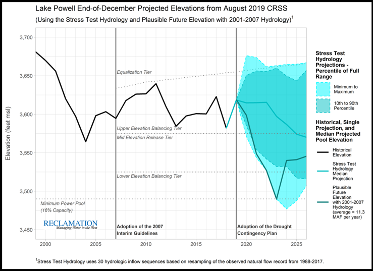
Lake Powell risks. Source: USBR
The line screaming down toward the bottom, in sort of dark greeny color, is the one to look at. A repeat of the drought of the ’00s could, with just four dry years, drop Powell to “power pool” levels. This is not some scary future climate change scenario. This is something that has actually happened in the recent lifetimes of folks working on the river today.
Our contribution (and really all credit to Anne’s thinking here, she’s the one who did most of the heavy lifting) involves a detailed discussion bringing together well-understood climate science and hydrology risks with less well understood uncertainties in the legal system. We have a lot of people right now arguing essentially, “Well, the Law of the River shows those other people will have to have their water cut!” So lawyer up!
There be the dragons.
Anne and I believe it’s important to have a clear and public discussion about the significant unresolved Law of the River questions as well evaluate our hydrologic risk, so we head into the next phase of Colorado River management discussions with our eyes fully open.
We shouldn’t over-emphasize scary worst case scenarios, because the odds that we’ll be on that worst case line are low. But they are not zero (this is a drought that actually happened not that long ago!), and failing to have a plan seems like something worth trying to avoid.
Among the options Anne and I consider:
- “Demand management” – essentially reducing water use now and banking the savings as a hedge. This has been done with great success in the Lower Basin, effectively avoiding the risk of curtailment there by banking water in Lake Mead.
- Negotiating broad agreements with the Lower Basin, trading off some of our risk against some of theirs.
- “Going bare” – deciding that the costs of insurance (by “insurance” we mean foregoing water use now as a hedge against future risk) are too high.