On the value of Colorado River Beat reporting

Tony Davis at the Grand Canyon, February 2018, courtesy Ry Rivard

On a Zoom call with a group of Colorado River brain trusters this morning, there was a realization that we’d all been talking in recent weeks to the same reporters.

Sometimes it’s someone new to the issues, looking for help with a single story. With dropping reservoirs, several pressing near-term political and policy questions, and a lousy runoff forecast, there’s a lot of that.

Often it’s one of the regulars – beat reporters who have been on this story for a while, who know its nuances well, and who offer their readers and listeners continuing coverage rather than a one-off.

In my journalism career, I did both kinds of work, but I always found far more value in the latter. It’s not simply that beat reporting allows the development and communication of more specialized expertise – although that’s important.

It’s that some kinds of stories demand repetition.

At its heart, the Colorado River story right now is pretty simple:

  • The river was overallocated from the beginning.
  • Climate change is making the problem worse.
  • We have to figure out how to use less water.

Lather. Rinse. Repeat.

This is the antithesis of traditional newsroom culture’s definitions. “But we said that already,” the editor asks. “What’s new here?”

The value of repetition is a lesson I internalized from one of my Albuquerque Journal editors. I’d been writing about an environmental contamination issue here in Albuquerque, and at one point she said to me, “This is important, John. Find a way to keep it in the paper.”

We’d find some new “news peg” – a new set of sampling reports, a bureaucratic process step – and in the course of adding this new bit of information we’d also, by way of filling in the background, remind readers of all the old stuff. It was our way of saying, “Hey, look over here, this is important!”

This is why I loved Tony Davis’s story in the Arizona Daily Star over the weekend.

Less water for the Central Arizona Project — but not zero water.

Even more competition between farms and cities for dwindling Colorado River supplies than there is now.

More urgency to cut water use rather than wait for seven river basin states to approve new guidelines in 2025 for operating the river’s reservoirs.

That’s where Arizona and the Southwest are heading with water, say experts and environmental advocates following publication of a dire new academic study on the Colorado River’s future.

That fourth point is the news peg – “NEW STUDY SAYS“. And the study, by the Utah State Colorado River team, is great, a really important contribution to framing the issues we face going forward. But the three points before it are just versions of things Tony and the other Colorado River reporters have said before. Before. Before.

I think it’s accurate to say Tony has been writing about the Colorado River longer than anyone working today. I treasure my conversations with him – so smart about Colorado River issues, so smart about Arizona water issues, so smart about journalism issues. Every time I talk to him he’s already thinking two or three stories ahead. Tony’s a reporter’s reporter.

No one story solves the information problems of a busy audience being pulled in a million directions. It’s repetition that matters. “Oh wow, that Colorado River thing is in the paper again, it must be important!” Which is why the beat work by people like Tony is such an important service.

Lather. Rinse. Repeat.

The “novel ecosystem” of Albuquerque’s valley ditches

The novel ecosystem that is the Los Griegos Lateral includes this very big, very old cottonwood

This morning’s Downtown Albuquerque News (some of my favorite Albuquerque journalisms, worth ever $ spent to subscribe) has an item on Middle Rio Grande Conservancy District board member Barbara Baca’s thoughts on ditchbank vegetation:

Through its vast network of irrigation ditches, the Middle Rio Grande Conservancy District is primarily in the water delivery business, but a big part of that job actually involves tending to the vegetation that grows next to the water. The area north of Central near the BUGarium saw a rather dramatic example of this recently when crews cleared out dozens of non-native trees along the ditch (DAN, 1/27/21) in an effort to blunt the advance of tree roots, which can erode ditch banks.

But what is good for the ditches does not necessarily look good when the job is done, and all that bare ground has lately been on the mind of MRGCD board member Barbara Baca. She told DAN that she’d like to see native grasses planted on the sides of ditches, on the theory that it would choke out tumbleweeds, discourage the growth of those problematic trees, reduce the need for ongoing maintenance, and maybe (just maybe) result in fewer of those every-obnoxious thorned goatheads.

“I think it’s just a smarter way to maintain the ditch banks – and a beautiful way too.”

Revegetation has not traditionally been a large focus of the conservancy district, she said, but she hopes to move the issue toward the front burner in the coming months.

“We need to have the conversation with the community,” Baca said. “I think there are some real possibilities.”

Where the river once meandered a broad valley flood plain, we now distribute its water through a spiderweb of channels across the developed valley floor – and in fact we have been doing so for hundreds of years. It’s a novel ecosystem, but a deeply historical one, and I love that Barbara is pushing for a mindful conversation about our desired future conditions for it.


A bad year on the Rio Grande: climate adaptation in real time

A bad start to 2021 on the Rio Grande

With another abysmal runoff forecast on the Rio Grande, New Mexico is entering a fascinating experiment, playing out in real time, in climate change adaptation.

The latest model runoff forecast, circulated this morning by the folks at NRCS, is for flow of just 59 percent of average where the Rio Grande enters central New Mexico at a place called Otowi. That’s a midpoint forecast, with a big uncertainty range with a couple of months of snow season to go. But even the best case scenario at this point in the model is for below-average flow.

The worst case scenario is awful.

As my UNM colleague Dave Gutzler points out, there’s some really important recognition of the impacts of climate change embedded in these numbers. The snowpack isn’t actually all that bad. But (thanks to many scientists working on this question, but especially Dr. Gutzler and his collaborators here on the Rio Grande) we now understand that we should expect, for a given amount of snow, less water actually ending up in the rivers.

It’s warmer. Plants take up more water, and more evaporates.

What we also see is a sort of policy window opening up. In John Kingdon’s classic work on policy formation (see the indispensable Paul Cairney on this) the political/policy system, with limited capacity to wrestle with all the things before it, ignores lots of stuff until it doesn’t. Attention lurches from thing to thing, and when it lurches in your direction, you’d best be ready. But, importantly, you’ll be much more successful in contributing in that moment if the people doing the lurching already know you’re there. (Dr. Gutzler is a great example of this. He’s been soldiering along for years making himself available to explain this stuff, and doing the research to advance our understanding. Much of my own understanding of climate change came from many hours, during my time as a journalist, sitting in his office in what amounted to a bunch of on-demand graduate seminars.)

On the Rio Grande, one of those lurches is happening, now, in real time.

Consider first the Elephant Butte Irrigation District, on the Rio Grande in southern New Mexico. Per Veronica Martinez in the Las Cruces Sun-News:

“Unless conditions improve in the late fall and winter, we can expect 2021 to be a critically low water supply year for the Rio Grande Project, perhaps the worst in the project history,” Phil King, the district’s water resource consultant, said.

Meanwhile upstream in the Middle Rio Grande Conservancy District, the stretch of river where I live, Theresa Davis reports:

The Office of the State Engineer recommends “that farmers along the Rio Chama and in the Middle Valley that don’t absolutely need to farm this year, do not farm,” according to a staff report that Interstate Stream Commission Director Rolf Schmidt-Petersen presented to the Commission earlier this month.

In my crazy new academic life, I’m watching this play out in real time with a couple of students, Tylee Griego and Talisa Barancik, who with funding from the South Central Climate Adaptation Science Center have been studying patterns of agricultural water use in the valley.

We’ve been exploring the distinction between commercial and non-commercial farming. There’s a gradation between the two, but the climate adaptation responses and opportunities seem very different. In places dominated by commercial agriculture, farmers seem farm more likely to drill groundwater wells to make up for surface water shortfalls. This is especially the case in the San Luis Valley, up in Colorado, and down in the Elephant Butte Irrigation District of southern New Mexico.

Here in what we call “the middle valley” – the stretch through central New Mexico that includes Albuquerque – the farming is far more likely to be non-commercial. It is people with a small operation and an off-farm job. Maybe it’s supplemental income, or maybe it’s just a “custom and culture” – farming as a thing integrated in a community’s life, rather than as a commercial economic activity. In “custom and culture” farming you see a lot less groundwater pumping.

These are the people more likely to be able to pull off Rolf Schmidt-Petersen’s “do not farm” recommendation.


Aldo Leopold’s Albuquerque

Aldo Leopold lived here, at the end of “New Albuquerque”, in the early 20th century

In the early 20th century, before Aldo Leopold became Aldo Leopold, the young forester lived on what was then the edge of Albuquerque’s expanding urban fringe.

135 14th St. SW SE sits today as a fine example of early 20th century “bungalows” that you might find in many western American cities. But when Leopold lived there when the house was built in the teens, 14th street was the edge of a city striving to modernity – growing city to the east, Rio Grande swampland to the west. A 1918 map I’ve got (not gonna post it, it’s super pixelated and poor resolution when you zoom in to Aldo’s house) shows 135 14th SW SE as literally the last house at the edge of the swamp.

The draining of that swampland, and much like it up and down what we in New Mexico call “the middle Rio Grande Valley”, is a central piece my friend and colleague Bob Berrens and I are zeroing in on as we begin dimly seeing the outlines of “our new book” emerge from our pandemic discussions.

The question we’re wrestling with involves the feedback between the evolution of Albuquerque as a city and the water management institutions the community created – community shapes institutions, which then shape community. Central to the story is a water management widget called the Middle Rio Grande Conservancy District, created in the 1920s to provide flood control, drainage, and irrigation.

Central to the Conservancy District story is Leopold, who spent two years (1918-19) running the Albuquerque Chamber of Commerce. Historian Denise Holladay Damico has written about Leopold in those years:

Leopold advocated passionately for the need for a centralized water conservation district, and the establishment of a civic center and civic identity, and city parks bordering the Rio Grande (which runs through the middle of the city). These same issues continue to swirl in public discourse today. At the heart of these debates are tensions between the individual accrual of private property and various notions of the public good. In his capacity as Chamber of Commerce Secretary, Leopold asserted that (what he called) “public spiritedness” was the way to resolve these tensions; however, just a few years later he publicly excoriated Albuquerque’s boosters for being short-sightedly profit-driven, suggesting some of the difficulties involved in balancing private rights with the public good. Can a “land ethic” be applied to American cities?

At the time, aggradation of the Rio Grande from the buildup of silt was a huge problem. The common explanation, which Bob and I will need to test, is that massive sheep overgrazing was contributing to erosion in upstream watersheds, which was raising the riverbed and therefore the water table through Albuquerque. Farmland was no longer farmable, flooding was increasingly common.

The young Leopold’s home was on the edge of one such swamp, so he had a very visceral understanding of the argument in favor of drainage. (Leopold had married into the Lunas, one of New Mexico’s wealthy ricos – the sheep families – see Wallace 2014 and the delightful Gulliford 2017 – it’s a complicated tale.)

Drains like these, built to lower the water table, serve as back alleys to New Mexico’s Middle Rio Grande Valley

The layers of colonization – Spanish immigrants from the south pushing aside native Pueblo communities, Pueblos pushing back, then Anglos from the east pushing aside both – play out in the formation of the Conservancy District, as the most recent layer of “modernization” was locked down across the Rio Grande valley floor.

The drains were built, one just a half mile southwest of the old Leopold home. The land between Leopold’s house and the river, once swamp, is now one of Albuquerque’s leafiest neighborhoods, including our Country Club. And the community was changed in complicated ways that Bob and I need to spend time disentangling.

Out riding Saturday, on a whim I diverted from the paved Rio Grande Boulevard onto the Griegos Drain ditchbank. Most of these valley ditchbanks are rideable – some little more than footpaths, others, like the Griegos, full-fledged dirt roads. Here, we think the drain’s construction in the 1930s wiped out the upper reaches of the old Barelas Ditch, which seems to have watered farms tended by our old friend Max Gutierrez and his many siblings.

What did they grow? Why did they stop? The clash between modernism’s drains and the old acequias is a central piece of the story.

I followed as best I could the path the Barelas Ditch had followed – past what we think was Max’s house (still there), down one of the crazy angled valley roads that you often find plopped down atop the old acequia routes. Past the freeway gas station on Second Street, beneath a place that rents cherry pickers, under the freeway and across the railroad tracks. The old Martineztown neighborhood, once built around the Barelas, is still there, and if you follow the ditch path far enough south you’ll find a little urban park commemorating the “Acequia Madre” that once flowed south here. At its east end the park opens onto Manuel’s, the last of the little neighborhood markets, which in pre-pandemic days smelled of the tamales the owner kept hot in a steamer – great bike ride snacks.

Here, the path of the Acequia Madre itself, now an alley, is fenced off.

The owner of Manuel’s, a woman New Mexicans would describe respectfully as an abuelita, buys the tamales in bulk from Costco.

Modernism is complicated.

Max will be in our story for sure. He’s an amazing character – bridging cultures, bridging past and future. One of the hard choices Bob and I will face is what role to give Leopold in our telling. He’s important, but from a storyteller’s perspective also the kind of character who could very easily take over the narrative.

But there’s time for all that.

update: Address of Aldo’s house fixed, thanks Bill.

Striking new study suggests how deeply we’ll need to reduce our use of Colorado River water

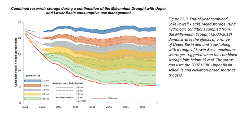
Stabilizing Colorado River reservoir levels under even moderate drought/climate change scenarios will require deeper water use reductions than basin managers have to date been willing to contemplate (at least publicly), according to a new analysis by researchers at the the Futures of the Colorado River project, based at Utah State.

Led by highly respected veteran Colorado River modeler Kevin Wheeler, the team ran sophisticated new climate and river flow data through the computer modeling tools used by basin managers to try to answer basic questions about how various possible policy interventions might play out as climate change depletes the river.

Among their key findings: Under a relatively optimistic scenario (things don’t get any drier than they’ve been in the first two decades of the 21st century), stabilizing the system would require:

  • The Upper Basin to not increase its uses beyond its current ~4 million acre feet per year of water use.
  • The Lower Basin to adjust to routinely only getting ~6 million acre feet of water.

So how do those numbers compare to current use and policy discussions?

Recall that the Colorado River Compact “promised” each basin 7.5 million acre feet per year. The Upper Basin water users since the late 1980s have averaged about that 4 million acre foot number, but with aspirational plans to take more. The Lower Basin water users have been reducing their use from the allowable 7.5maf, using 6.9maf on average over the last five years.

So to balance things out, Upper Basin use can’t grow, Lower Basin use needs to shrink. More thank it already has.

Remember that’s the optimistic scenario. Under plausible climate change scenarios, the cuts would have to be deeper.

The results are, in some sense, unsurprising. We know that if there’s less water, people will have to use less water. And the best science, combined with the last two decades’ lived experience, suggest we’ve got less water to deal with on the Colorado River.

What’s great here is the details – a credible incorporation of the best climate science into the current Colorado River Basin policy framework, with an analysis done using CRSS, the modeling tool the management community uses to think about the Colorado River. This report, in other words, is written by a team deeply fluent in the language of Colorado River management.

The USU team has put together a nice executive summary of their findings, and the full report is here.

(Disclosure: I am an uncompensated member of the project’s advisory panel, but I didn’t play any active role in the report’s preparation beyond a lot of chit-chat with report co-author and my longtime collaborator Eric Kuhn as the work was being done.)

In which I write about manure

The latest product of my eclectic new academic career – a paper about manure.

Manure disposal is a growing problem as agricultural specialization leads to ever-larger concentrations of farm animals. Animals and crops were once grown on the same farm, creating an easy path for manure disposal on cropland in a cycle from animals to feed crops and back. Increasing specialization today means that concentrated animal operations are no longer linked to adjacent cropland on which animal waste can be disposed, leading to significant off-farm externalities in the form of risks of air and water contamination. Using an arid lands case study of dairies and crop and grass land in New Mexico, USA, we explore the possibility of reintegration through the analysis of available crop and range land in the scale of counties and watersheds surrounding the state’s concentrated dairies. We find that there is often available land to make productive use of the waste. However, in developing the policy tools to reintegrate the animal waste-crop cycle among independent farms and ranches, it is critical to consider the appropriate geographic scale.

Suraj Ghimire, a UNM Economics grad student, did the heavy lifting here, with mentorship from my faculty colleague Jingjing Wang. My piece was small, and can be seen near the paper’s end – the institutional challenge of overcoming the coordination problem associated with manure disposal as dairies increasingly operate at a scale substantially larger than the immediately available land around them for farm field manure disposal.

2020 – as dry as a tumbleweed metaphor in a bad western. But compost!

Red – the roads not yet ridden, courtesy Wandrer

“Well, you have your compost!” – L. Heineman

The Man from Tumbleweeds (1940) - IMDb

We got 5.88 inches of rain this year at the “official” Albuquerque airport weather station, which for perspective is essentially a one-in-six dry year based on over a century of records. But we got 7.05 inches at our house. Plus, as Lissa pointed out, I have my compost.

Yes, my compost. This morning I found a plate of peels Lissa had lovingly preserved from her evening tangerine snack.

Treasure!

It has become a neighborhood project. I converted an old stock tank we’d been using as a pond, and my neighbors Alison and Larry contributed a compost tumbler they weren’t using and bags of leaves (“We’ll leave them under the trees on the south side of the yard if you want any,” Alison texted. Of course I wanted them.)

Leaves go in the tank, and after a starter of leaves the tumbler gets the kitchen scraps (the better to protect them from what might be a backyard squirrel, lurking in the night).

After twirling the tumbler, I always peer in and take stock of the little crawly things doing their compost duties, a tiny ecosystem, a little miracle. The life force, an old friend once told me with a tone of Catholic reverence, is strong.

As you know, some bad stuff happened in 2020. I’ve got nothing much to add there, beyond the fact that Mom didn’t die. “There are things which are within our power,” Epictetus wrote, “and things which are beyond our power.”

Kewa Station, March 1, 2020

In retrospect, I can see the collapse already beginning in March, when my friend Scot and I rode the Railrunner, New Mexico’s commuter train, up to the Kewa station two thirds of the way to Santa Fe, with our bikes. We’ve an informal rule that we don’t put our bikes in a car and drive to a place to ride – gotta ride out the door. But we’d been experimenting with public transportation as a range extender – first Albuquerque city buses, then the train.

Scot’s a bike touring veteran, but the 50 miles back from Kewa (plus the 4 1/2 from my house to the station to catch the train) had been a stretch goal for me.

I don’t specifically remember tumbleweeds, but the station had a tumbleweed-blowing-across-the-highway western movie feel. Train pulled off, lone auto picking up a rider pulled away, and we had the whole place to ourselves – colonizers on Kewa land.

There was a stop at the irrigation diversion dam at Angostura, and this being the Time Before there was a taco stop in Bernalillo. It would be another two weeks before last tacos – two weeks etched in memory – a crazy quick weekend at Hoover Dam to film a documentary, that last Thursday meeting with my students, the awkward start of a spring break that never ended, melting into one endless Zoom class.

The thing within my power

In the manner of Epictetus, the bike has become the thing within my power, and I have in response ridden it a lot.

As I have written before, I’m no longer zoomy. At 61 years of age, I ride now for place – #geographybybike, as my friend Maria Lane (an actual geographer) dubbed it. This year that has been 6,396 miles, slowly, an hour-and-a-half a day on average, almost entirely in and around Albuquerque. That is, for me, a crazy lot of miles, far more than I’ve ever ridden in a year.

Early on, as the pandemic shrank my world, the riding was frenetic. With so little within my control, I obsessed over the tools I needed to mount more water bottle cages on my bike, poring over the maps and my old GPS ride archives in search of the places I had not been. Epictetus overkill. With the taco truck option epidemiologically foreclosed, I’d coordinate with Lissa to make her magical quesadillas, looping home for a lunch break before heading back out for more miles. That compressed the geography further, kept me closer to home even for the longest of rides.

Closer to home, a comfortable tether.

By summer the frenzy had calmed, and I settled into a rhythm – ride most very day, with a not-quite-so-long Sunday ride, a tentative return to riding with Scot and lunching at the taco trucks.

This fall I discovered the wonderful Wandrer, a tool that allows you to upload all your old GPS traces, building a map of the roads you haven’t yet ridden. I’ve GPS’ed every ride since 2007-08-ish, and was delighted to find all the roads yet to ride.

I have, in other words, found a comfort in the things within my power – lines on a map which only I can draw, one pedal stroke at a time. Compost in the garden.

I didn’t mean to write a blog post about bicycling. As I start to work on a new book, I’ve offered my collaborator, by way of explanation of process, what has long been an amazingly useful metaphor:

You’re standing at the edge of a mountain stream, too wide to jump, too cold to comfortably wade. It’s strewn with rocks, and you start across, one rock at a time, hoping you can imagine a route a few hops ahead, but unsure of the exact path. That’s the way writing is for me, mostly joy, sometimes I fall in and get really cold and wet.

I started today with my morning weather data, then Lissa suggested compost. So I hopped onto the first rock, then, the second.

2020 bike riding had been in the back of my mind – or to follow the metaphor, a jumble of rocks midstream. Epictetus has been a handy rock since the first time I read him 40 years ago. (I was surprised to run a search and find I’ve never used him before.) There’s a pile of rocks over to the left that you may read about eventually, involving Lake Mead’s elevation and total Lower Colorado River Basin water use, etc. Another pile to the right that involves path dependence and the institutions of water management. Not touching that one – I’m sure to fall in.

Census of Agriculture

Metaphors do the most useful work as they are breaking down. The stones aren’t so much laid out in the stream in front of you – they’re things you find, tossing them ahead to make it easier to cross the stream.

As near as we can see the path across the stream at this point, the new book will be about the Rio Grande and the making of modern Albuquerque. It’ll probably talk about sheep, and a remarkable guy named Max.

I’ll be finishing my time as University of New Mexico Water Resources Program director this summer, to free up more time for said book. I hope to still have a role at the university, working with water students and faculty, perhaps teaching, and wandering ’round the Duck Pond on sunny post-pandemic afternoons. (Plus I’m writing a book, university library privileges, amiright?)

And Scot and I have already been poring over the maps for tomorrow’s New Year’s Day ride, new lines on a blank 2021.

No taco trucks, but Lissa made oatmeal cookies.

2020 in a nutshell (I did at one point, when the weather was warm, figure out how to mount four water bottles on the frame)


The circuitous path to Max Gutierrez’s grave

Max Gutierrez Sr., 1887-1952

It at some point may become necessary, and valuable, to backtrack and trace the path that led us to Max Gutierrez’s grave last Sunday.

It was my friend Scot who found Max’s grave, which is appropriate because it was Scot who found Max. Scot had already found what he thought might be Max’s house, on Griegos Road in what we now call Albuquerque’s North Valley. A little abandoned irrigation ditch ran behind the house which we might never have spotted if not for Scot’s cheerful obsession with Google maps satellite view.

Scot, who loves to read old newspapers, found Max after I tossed out a question about what farmers were thinking back in the 1920s about the future of agriculture in the Albuquerque valley as the modern institutions of flood control, drainage, and irrigation were being created. In Scot’s reading, Max’s name kept showing up.

We’d already been planning a Sunday bike ride to see Max’s old neighborhood when Scot emailed early Sunday morning to add a stop to our itinerary – Mount Calvary Cemetery in the old Santa Barbara neighborhood, where his sleuthing had unearthed what looked like Max’s grave.

Scot’s research skills are a thing to behold. “This internet has all kinds of stuff,” he said.

“It was said that Ofimiano used a cane”

Albuquerque Morning Journal, Wed. Jan. 15, 1919

The histories of Albuquerque generally barely mention Max, which is a shame. The steady stream of old newspaper clippings Scot has been sending suggest a character worthy of note. Here’s one example, in which Max, a Republican, takes to bed after an affray with his brother Ofimiano, a Democrat, on the occasion of Max’s 1919 Bernalillo County Commission election victory. Ofimiano seems to have been the losing candidate.

You just can’t make up shit this good.

The old 1918 survey maps of the Rio Grande Valley show an alfalfa field behind what we think was Max’s house, and thanks to research by my friend Bob – the third member of what has become Team Max – we know that Max’s occupation was variously listed in old census records as “farmer” and “rancher”, and in addition to his political career he also seems to have served for a time as a sheriff’s deputy.

Alfalfa has long been our dominant crop, and Bob thinks Max was likely running sheep on the mesa’s that flank the Rio Grande Valley here. (There also is some evidence of Max running cattle near Cuba, New Mexico, and of gunplay involving Max’s brother-in-law, and a dog. See above about not being able to make up shit this good. Max is a worthy subject.)

My life in the Time of Pandemic

Max Gutierrez sits at the convergence of two friendships that have been central to my pandemic life. Now nine months in, my world has collapsed onto my own family, especially Lissa; teaching; long bike rides with Scot wandering the valley floor looking at old ditches and feeling the shape of the city; and long talks with Bob, mostly walking around our park or sitting on Bob’s porch, trying to make sense of the history of farming and water and Albuquerque’s urban form.

These things take time. We have time, to slow down and work things out.

“little ditch”

In our bike ride planning emails, Scot had asked me to try to run down the name of the abandoned ditch behind Max’s house on Griegos. My old Middle Rio Grande Conservancy District maps identify it as a piece of the old Barelas Ditch – also known, per the map’s metadata, as “little ditch”. More work on this point is needed, but the 1918 map seems to show it running southeast across the valley floor, across a blanket of irrigated land, turning south through what is now the light industrial/warehouse district a block west of the cemetery where Max is buried.

The story of this ditch may matter. Bob (it’s great to have smart friends with research skills) has found what seems to be evidence that Max at one time owned a number of pieces of property scattered along the general path of the Barelas Ditch.

the Los Chavez riot

To the extent that Albuquerque histories mention Max at all, it is generally in the telling of the story of what the newspapers of the time called “the Los Chavez riot”. It’s a key plot point in our Chinatown/Owens Valley narrative, as Hispanic farmers stood down the heavy equipment of the newly formed Middle Rio Grande Conservancy District. The district in these tellings represents the push toward modernity, digging new drainage ditches that forever reshaped the old acequia irrigation of the valley. Like Chinatown and the Owens Valley, much of the modern telling has a suspicious ring as the story is pressed into the service of the morality plays imposed on the past by our modern minds. But Max for sure comes off as a heroic character, leading the litigation aimed at stopping the district and trooping down from Albuquerque to Los Chavez the day of the “riot”.

The Albuquerque Journal of June 4, 1930, describes the sweeping extent of the charges leveled against Max and his fellow travelers:

The defendants are charged with conspiracy to alienate the confidence of Indians of the Pueblos from the government as a result of speeches and talks they are alleged to have had with the pueblos of Santa Ana, Santo Domingo, Cochiti, Isleta, Sandia, and San Felipe.

There remain questions in our minds about which side had guns the day of the Los Chavez riot. Further research needed.

The Rio Grande and the Making of a Modern American City

Some years ago, when I was invited to write an introductory essay for a water-themed issue of the Natural Resource Journal, I wrote this:

“Say you are in the country; in some high land of lakes. Take almost any path you please, and ten to one it carries you down in a dale, and leaves you there by a pool in the stream,” Herman Melville wrote in the opening chapter of Moby Dick. “There is magic in it.” It is always down – simple gravity and fluid mechanics mean water occupies a landscape’s lowest spot. It is also instructive. To learn about a new place, I’ve found, you can always start with its water.

And so I find myself, as I ponder my next book, in conversation with two smart friends about Max and the history of Albuquerque and the Rio Grande.