The Rio Grande’s shrinking snowpack

A dry January in the Rio Grande headwaters means a shrinking runoff forecast.

  • Otowi (the Compact measurement point on which New Mexico’s Texas delivery obligation is based): 78 percent, which is down from 90 percent on January 1.

Still big error bars, because the most important variable is how much snow we get in February and March.

Taking New Mexico’s Gila water from the San Juan?

Old John Fleck would have happily explained to you why this from Bruce Babbitt is a terrible idea:

Damming the Gila River is a vampire proposal that would suck the life out of Southern New Mexico’s most treasured wild and scenic river.

Gov. Michelle Lujan Grisham wants to kill the project. Both of New Mexico’s U.S. senators have tried to withdraw federal funds. Public opinion is against it. But like the vampires of legend, it refuses to die.

A better alternative is to take New Mexico’s water entitlement from existing dams on the San Juan River in Northern New Mexico.

New John Fleck is intrigued, based on a recognition that we need to find ways to expand the policy option space for dealing with Colorado River governance in the coming five years.

On the “terrible idea” side of the ledger is the breaking of one of the Law of the River’s great taboos – moving water across the Upper Basin-Lower Basin Lee Ferry boundary. Taking Gila River water (Lower Basin water!) from the San Juan (an Upper Basin tributary!)? And then, once we get the water across the continental divide into the Rio Grande Basin, we have yet another boundary to cross in the form of the Rio Grande Compact’s bizarre rules surrounding water moving past Elephant Butte Reservoir to the places Babbitt is rightly suggesting have a need for the water.

The institutional challenges here, in terms of needed interstate political agreement and rules changes, are staggering. I have a whole family of “that’s too hard” arguments at the ready for things like this. This is Old John Fleck.

But as we head into the process of renegotiating the river’s operating rules over the next five years, New John Fleck is increasingly interested in expanding the range of policy options we consider, not shrinking them.

I’m not sure I’d have the guts to pitch this particular idea, but I’m intrigued. Better Bruce Babbitt than me!

Some other stuff I’m up to – climate change impacts research

Natalie Rogers did a nice writeup for the University of New Mexico on some work I’m doing with a group of University of New Mexico colleagues on climate change impacts and adaptation in New Mexico.

Working as part of a new affiliation between UNM researchers and the USGS-funded South Central Climate Adaptation Science Center, some students are I are taking a deep(er) dive into the evolution of agriculture in the Rio Grande Valley of New Mexico and southern Colorado over time as climate change reduces surface water supplies.

This is an outgrowth of conversations my UNM Economics colleague Bob Berrens and I have been having as we teach in the UNM Water Resources Program core. In particular, I’m interested in disaggregating agriculture – recognizing that “agricultural water use” is not one thing, varying significantly among the acequias of Northern New Mexico and southern Colorado, the cultural farming of the pueblos of the New Mexico’s middle Rio Grande Valley, and the money farming done in the pecan orchards of the southern part of the state. We’re convinced that lumping “agriculture” together misses distinctions that are important for thinking about climate change adaptation.

Interested in this sort of thing? We’re now accepting applications for fall 2020!

Breaking through the Colorado River clutter: Science Be Dammed

Eric and I could not be more happy about this from John Berggren.

There are countless Colorado River resources available to learn about the history of how the river has been and continues to be governed. Hundreds of books, reports, studies, and papers have been written on the subject. Accordingly, it takes something quite new and novel—and credible—to break through the masses and rival Colorado River classics such as Norris Hundley, Jr. and Marc Reisner’s work. Eric Kuhn and John Fleck have undoubtedly done exactly that in their new book Science Be Dammed: How Ignoring Inconvenient Science Drained the Colorado River.

John, who did his doctorate at the University of Colorado studying Colorado River governance, now works for Western Resource Associates, and is one of the smart next generation of water thinkers whose help we need to get out of our current mess(es), argues thus:

If you have ever seen a talk or lecture about the Colorado River, you have almost certainly heard the refrain: when the negotiators divvied up the river in 1922, their period of record for streamflow was unusually high. They believed the river’s annual flow was at least 17.5 million acre-feet (MAF) and able to supply what the states could reasonably develop in the coming decades. Unfortunately, that 17.5 MAF ended up being much higher than the approximate 14 MAF we see today and because of that, they accidentally over-allocated the river.

But as Kuhn and Fleck dug into the record, they discovered the reason for over-allocation was more complicated, nuanced, and ultimately political rather than scientific.

But that was not the only time….

What becomes especially troubling is that Kuhn and Fleck continue to find this trend throughout the rest of the 20th century as further agreements were decided upon, water infrastructure projects were proposed and built, and we saw the continued evolution of Colorado River governance, known collectively as the “Law of the River.”

The full review is in Water Alternatives, an interdisciplinary journal on water, politics, and development.

Some more Colorado River 2019 data updates

We’re diving into a semester studying (and modeling) Colorado River management in the University of New Mexico Water Resources Program. We’ve got a smart group of next-generation water managers, and we’ll be using the Goldsim modeling platform to build some system models. The students will be helping me think through the set of questions folks in basin management are grappling with as we think about what the management rules, due by the end of 2025, should look like.

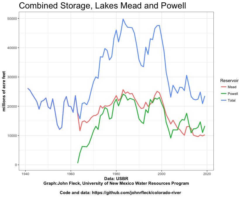
Getting ready for class this week, I realized I hadn’t updated my datasets, which we’ll be using in class. I’ve put a few of them on Github, data I’ve assembled that isn’t easily accessible in a single place and that I find useful. One of the important things I’m trying to help students with is the endless and important task of data hustling in the service of policy analysis. Here’s an updated version of the graph of storage in Lake Mead and Lake Powell, with water-year end final numbers.

Water storage in Lake Mead and Lake Powell


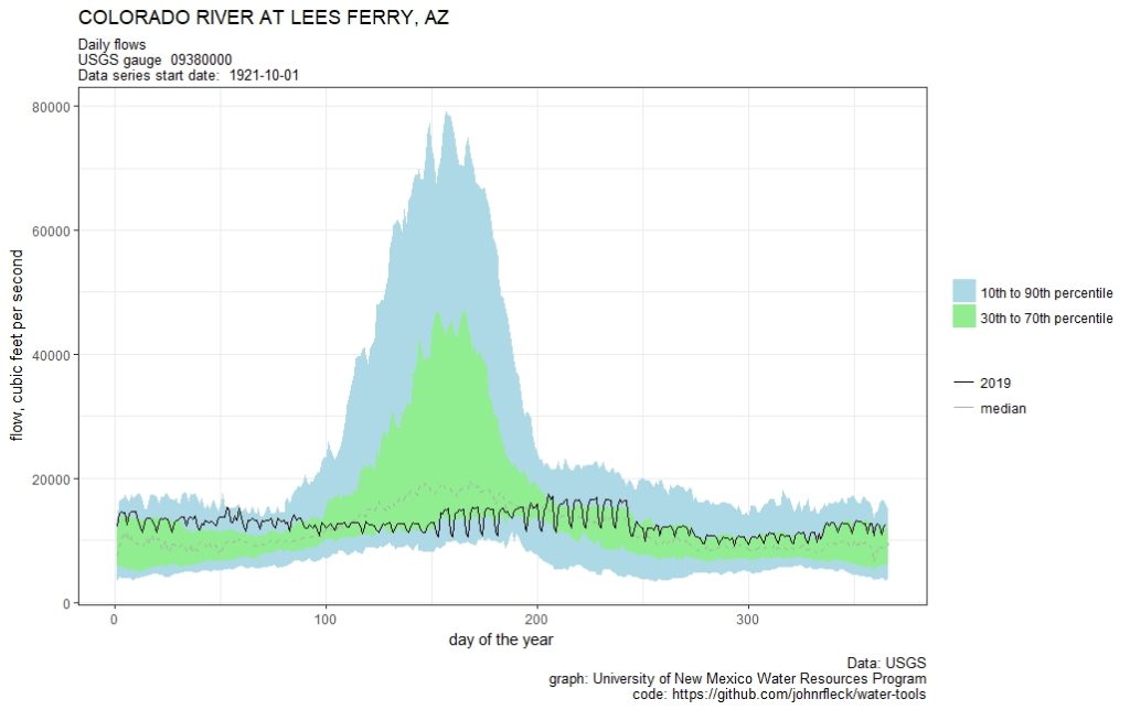
Tracking the Colorado – flow at Lee’s Ferry

2019 flow on the Colorado River at Lee’s Ferry

One of the things I do with the students in my University of New Mexico Water Resources classes is try to develop the habit of paying attention, through repetition, to the available data on the systems we’re talking about.

We use USGS river gauges to do this – checking the gauges is a classroom routine.

This spring, we’ll be focused on the Colorado River. Class starts next week, and in getting into the rhythm myself I made the above graph of flow at Lees Ferry, the gauge just below Glen Canyon Dam, at the head of the Grand Canyon. It’s arguably the most important river gauge in the West (Eric Kuhn and I wrote a book about that and some other stuff, we have a whole section explaining why “Lees” has no apostrophe) but as I plotted the 2019 Lees Ferry flow I couldn’t help but feel like this is a very boring graph. Flows are, umm, stable.

Getting my students to start paying attention to this particular gauge may not achieve my pedagogical goals.

A rising Lake Mead? Or just hovering around a new elevation line

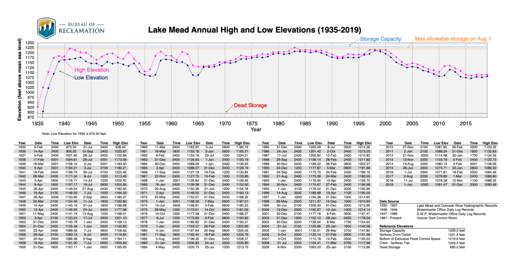
Lake Mead elevation. USBR graph

A member of the Colorado River brain trust argues that when you use reservoir elevation to define an action level of some sort, the reservoir remarkably ends up hovering around that level. The updated annual USBR Lake Mead elevation chart, just published with the 2019 data, nicely illustrates their point.

The 2007 Interim Guidelines set elevation 1,075 as the action level for the first tier of Lower Basin water use reductions. When the reservoir drops to that level (insert complicated rules about how and when the determination is made), cutbacks. You can see that in the years that followed, Mead dropped toward 1,075. In fact it actually dropped past it in 2015 and 2016 but bounced back sufficiently that we never actually triggered the cutbacks.

This year, the Basin community adopted new rules under the “Drought Contingency Plan” that created a horribly named “Tier Zero”, with cutbacks now triggered at elevation 1,090 (insert an even more complicated layer of rules about how and when the determination is made).

Mead’s lowest 2019 elevation was 1,081.47 on Jan. 1. Its highest elevation was at midnight Dec. 31, at 1,090.49.

Hovering around the line.

The risk of Southern California falling into “perfect drought”

Last year was, for Southern California water management, perfectly wet. By that I mean a good snowpack in the Sierra Nevada and the Colorado River Basin.

I’m stealing a wonderful phrase here from a new paper by the University of Arizona’s Connie Woodhouse (the full paper’s behind a paywall): “A Long View of Southern California Water Supply: Perfect Droughts Revisited.”

The impact of drought on water resources in arid and semiarid regions can be buffered by water supplies from different source regions. Simultaneous drought in all major source regions — or perfect drought — poses the most serious challenge to water management. We examine perfect droughts relevant to Southern California (SoCal) water resources with instrumental records and tree?ring reconstructions for the Sacramento and Colorado Rivers, and SoCal.

Woodhouse and colleagues found five “perfect droughts” in the 20th century, which they concluded was not unusual when they used tree rings to extend the record back in time. But….

Although the causes of perfect droughts are not clear, given the long?term natural variability along with projected changes in climate, it is reasonable to expect more frequent and longer perfect droughts in the future.

Megdal honored

picture of Sharon Megdal

Sharon Megdal

Happy to report that my friend Sharon Megdal, head of the University of Arizona Water Resources Research Center and a member of the Central Arizona Water Conservation District Board, has been honored with the University Council on Water Resources Warren A. Hall Medal.

Sharon’s a wonderful example (and role model for me as a new academic) of community-engaged scholarship, spanning the boundary between the university and the water management world.