Could water from retiring coal plants help solve the Upper Colorado River Basin’s “demand management” problem?

By Eric Kuhn

As the states of the Upper Colorado River Basin work through how to build a “demand management” account in their reservoirs to protect against shortages, water from retiring coal plants could play a crucial role. With few alternatives for use of the water, simply banking it in Upper Basin reservoirs is an attractive option.

In a recent KUNC piece, Luke Runyan discussed the impact of Tri-State G & T’s decision to close its coal-fired power plant near Craig, Colorado. Luke focused on the impact of the closing on the local community and options for the water rights that will be freed up when the plant is closed.  The Craig Station is one of ten major coal-fired power stations that were built in the Upper Colorado River Basin from the mid-1960s through the early 1980s. Several smaller plants were also built in the 50s, now all shut down. These plants were spaced throughout the basin with three in Utah, two each in Colorado, Wyoming, and New Mexico, and one in Arizona’s small portion of the Upper Basin, the Navajo Generating Station near Page, AZ.

For many reasons – their age (most are approaching their design life), high operational costs, and the need to reduce carbon emissions – these plants are being de-commissioned.  In 2014, three of the five units of the San Juan Plant in Northwestern New Mexico were shuttered followed by two of the four units of the neighboring Four Corners Plant in 2017. Last year, the Navajo Generating Station produced its last power and Tri-State made the decision to completely close the Craig Station by 2030. Further, last year the owners of the remaining operational units of the Four Corners and San Juan Plants in New Mexico and the Naughton and Bridger Plants in Wyoming made it clear that each will be shut down sometime in the next decade or so. By the early 2030s it’s likely that there will be no operating coal plants in the Upper Basin (the possible exception being one of the plants in Utah).  This raises the question explored by Luke Runyon. What will happen to the water that these plants were once consuming?

The source of cooling water for all these plants is the Upper Colorado River or one of its tributaries.  According to the Bureau of Reclamation’s Consumptive Uses and Losses Report, their 1991-2018 annual consumption averaged 162,000 acre-feet per year. At the peak in 2006, these plants were collectively consuming over 170,000 acre-feet of the Upper Basin’s compact share.  In 2018, it had fallen to 144,000 acre-feet. Recognizing that the total consumptive use in the Upper Basin is a bit over four million acre-feet per year (not counting CRSP reservoir evaporation), a reduction of 4% may not seem like a big deal, but a closer look suggests that it could be very significant.

Upper Basin use

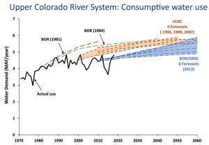
First, the Upper Basin’s total annual consumptives use have been flat since the late 1980s (see this nice analysis by Jian Wang and David Rosenberg at Utah State). The reasons are simple. The last major irrigation and export projects (trans-mountain diversions) were largely completed by the mid-1980s.  Except for the Lake Powell Pipeline (which may not be considered an Upper Basin use under the compact), there are no serious proposals for new export or irrigation projects (Denver Water’s Moffat Expansion and Northern Water’s Windy Gap Firming Project are tweaks to existing projects). Some have suggested the plant water could be sold or made available to existing export or irrigation projects. That is very unlikely. The diversion points for the existing trans-mountain diversions are far from the locations of these plants. Moving plant water to the Continental or Great Basin Divides would be very expensive.  The non-use of the plant water rights could in some years benefit existing irrigation supplies, but for the most part irrigation users already have senior rights and the irrigation of new lands would require large new public subsidies, an unlikely event. Further, much of the internal municipal growth within the Upper Basin is displacing existing irrigated agriculture where the net change in consumptive use is small or even negative.  Since it’s subject to the vagaries of regional precipitation and water supply conditions in adjacent basins such as the South Platte where water is exported to, consumptive uses in the Upper Basin will continue to be variable on a year-to-year basis, but it is clear that the loss of 160,000 acre-feet of consumptive use over the next decade will be measurable and will likely contribute to a downward trend.

Second, 160,000 acre-feet of consumptive use per year is actually a lot of water.  Only a few of the Upper Basin’s largest projects, the C-BT and Uncompahgre Projects for example, consume more. Water efficient cities such as Las Vegas or Phoenix could serve more than 1.5 million people with this amount of water. It’s over half of Nevada’s use from Lake Mead and close to half of the average annual use of the upper states of New Mexico and Wyoming.  Between equalization releases (the last one was 2011), Lake Powell has “memory.” It stores every extra acre-foot of inflow. Without the coal plant use, an additional 1.4 million acre-feet of post-2011 water would be in storage there today.

Finally, for the implementation of the drought contingency plans (DCPs), 160,000 acre-feet of water could be a very useful and significant asset.  The States of the Upper Division are currently studying the implementation of demand management. The federal legislation approving the DCPs gives these states access to 500,000 acre-feet of Lake Powell storage space.  A strategy to fill this space with 100,000 acre-feet of conserved consumptive use per year (primarily from existing agriculture) over five years would be a huge political challenge and cost $25 million per year or more.  The 160,000 acre-feet of unused plant water would fill that same space in about three years.  The challenges for the upper states will be first to take a realistic look at their future demands and factor in both the upward and downward trends, and to figure out how to incorporate these plant closures into their post-2026 river management strategy.  If they can’t, gravity will ensure that the Lower Basin is the ultimate water beneficiary of the closing of these plants.


We keep projecting that water use will go up. We keep mostly being wrong.

Jian Wang and David E. Rosenberg at Utah State have put together an incredibly helpful compilation of past projections of Upper Colorado River Basin consumptive use, as compared to what then actually happened:

When averaged over the long term, each scenario of future consumptive use over-estimated the observed consumptive use.

Upper Basin use

Herein lies the space for problem solving.

Robert Moses, the Colorado River, and the tragedy of the anticommons

[T]he anticommons refers to situations where there are numerous overlapping rights holders (or what might also be seen as numerous policy advocacy coalitions) each with some power to veto or block system or operation change. The tragedy emerges when the composite effect of such power prevents significant change in the system.

– Jones, Benjamin A., et al. “Valuation in the anthropocene: exploring options for alternative operations of the Glen Canyon Dam.” Water Resources and Economics 14 (2016)

Wandering the halls of Bally’s in Las Vegas last December, at the annual meeting of the Colorado River Water Users Association, I received a text from a friend with a link to a piece in Politico by Marc Dunkelman about the late New York power broker Robert Moses.

Robert Moses turning models into a reshaped city. Library of Congress. New York World-Telegram & Sun Collection. http://hdl.loc.gov/loc.pnp/cph.3c36079

Dunkelman spins a wonderfully readable tale of New York’s Penn Station, in particular why it is so awful. Because despite everyone knowing this central Manhattan transportation hub needs to be fixed, and lots of people having good ideas about how to do it, and projects to carry them out, Penn Station remains awful:

In a dynamic where so many players can exercise a veto, it’s nearly impossible to move a project forward. No one today has the leverage to do what seems to be best for New York as a whole.

When I bumped into my friend later that day at Bally’s, I shared my puzzlement. Why was I being encouraged to read about Moses and Penn Station?

I have long argued that a robust governance network, both formal and informal, around the management of the Colorado River provides the necessary conditions for managing the problems of the river’s overallocation and the increasingly apparent impacts of climate change. That’s the argument at the heart of my last book, Water is For Fighting Over: And Other Myths About Water in the West

But as we approach the negotiation of the next set of Colorado River management rules – a process already bubbling in the background – it is not hard to see how my thesis could break down. The problem is an institutional structure that has distributed veto power across the Colorado River Basin.

I’ve been thinking a lot about my friend’s “read about Moses” tip in the months since CRWUA.

Moses, the “master builder” of modern New York who famously ran roughshod over – well, over everyone who didn’t agree with his sometimes troubling vision – left in his wake a reaction against such concentrations of power.

The progressive movement that arose in opposition created mechanisms to prevent another Moses from doing Mosesy things. Decades later, as Dunkelman documents, the veto points created to accomplish this reining in of power have made it impossible to fix Penn Station. While everyone agrees that the fixing is needed, lots of people disagree with the specifics of any one proposed fixed. And those people have a veto. So the fixing never gets done.

We have a similar problem in the Colorado River Basin. The river’s water allocation schemes are broken. Eric Kuhn and I spent a good deal of time laying out how that brokenness came about in our new book Science Be Dammed. We spent some time sticking our necks out with some of our ideas about what fixing it might look like. But as the discussions about a new river management ruleset bubble away, it is clear that we’ve got a problem very much like post-Moses New York: lots of people have a veto over any new scheme that we or anyone else might cook up.

The origins of the problem, in New York versus the Colorado River Basin, seem different. Where in New York the distribution of veto power arose in response to harms at Moses’s hands, in the Colorado River Basin the problems were baked in at the start. A federalism that left water management to individual states, combined with a compact that effectively gives each of the seven basin states (and, I guess, the federal government, and probably Mexico, and maybe going forward 29 sovereign Tribal nations, and increasingly an effective environmental community) a veto over any potential fix leaves us with a Penn Station-like gridlock. Here’s how I described the problem five years ago:

The first time I wrote about Terry Fulp, a key manager with the Bureau of Reclamation, I described him as “the closest thing we have to a guy with his hand on the tap that controls the vast plumbing system built over the past century to distribute the Colorado’s waters.” But I have come to realize in the years since I published that line in 2009 that, in reality, no one has their hand on the tap, and nobody has the ability to turn it down. Instead, we’ve built a decentralized system with no one in charge.

When I wrote that, I don’t think I full grasped the corollary – not only is no one in charge, but lots of people have the power to block solutions they don’t like.

After a talk I gave about the new book last week at the University of New Mexico School of Law, a student asked me the obvious question: We don’t we simply proportionally reduce everyone’s allocation to match hydrologic reality?

This of course makes perfect sense. But it is impossible in a system where major parties have deeply held views about fairness and equity and why they should keep their full allocation while those other people in that other place, who have been far less responsible, suffer the burden of shortage. And where the institutional structures effectively give all those parties a veto over such a solution.

University of Michigan legal scholar Michael Heller slapped a wonderful label on the problem some years back – “The Tragedy of the Anticommons“. I’m bending Heller’s original case to apply it here. But the idea of the existence of multiple veto points over solutions to commonly shared problems seems to hold, here and in many many other cases. (There has been a great deal of bending of Heller’s original anticommons idea since he first published it – it’s a pretty rich conceptual framework.)

My University of New Mexico colleagues Bob Berrens and Benjamin Jones are among those who have written about this in the context of Colorado River management (it was Bob some years ago who turned me on to Heller and the “anticommons” literature – Bob and Benjamin were writing the paper I link to at the same time I was writing Water is For Fighting Over):

[T]he anticommons refers to situations where there are numerous overlapping rights holders (or what might also be seen as numerous policy advocacy coalitions) each with some power to veto or block system or operation change. The tragedy emerges when the composite effect of such power prevents significant change in the system, and suboptimal use of limited resources. Like the better-known tragedy of the commons, the tragedy of the anti-commons also represents a coordination problem.

Jones et al (Bob and Benjamin and colleagues) suggest a path forward:

Governance processes for finding pathways through such coordination problems (e.g., to system operation changes), may benefit from improved information about the full range of preferences held across a population and argued in the policy domain. For example, broader system perspectives are more likely to find flexible least-cost alternatives to operational changes.

I don’t have an ending here. I’m not sure where to go with this.

The solution so far has been a series of incremental fixes that have avoided the risk of veto-triggering disputes. Maybe this argues for more of that – more incrementalism, rather than the sort of “grand bargainy thing” some of us have been advocating.

Retiring coal plants as a Colorado River Basin demand management strategy

OK, “strategy” is not exactly the right word here, but we take our water conservation where we can find it, eh?

Luke Runyon took a nice dive into the water supply implications of the West’s wave of coal plant retirements. Because coal plants use water. Here’s my coauthor Eric Kuhn on the implications:

“As a legal matter, the owners of the water rights, at least in Colorado, could do something else with them. As a practical matter, there’s not much else they can do with them,” said Eric Kuhn, former head of the Colorado River District and author of Science Be Dammed: How Ignoring Inconvenient Science Drained the Colorado River.

TriState has limited options with the water rights, Kuhn said. The energy provider could sell them to a local municipality, though communities along the Yampa River, like Steamboat Springs, Hayden and Craig, likely wouldn’t be able to use that much water all at once. TriState could offer them to local farmers, though most of the easily irrigable land has already been irrigated for a long time. They could turn them into in-stream flows. Or they could sell them to a user outside the Yampa basin, like a Front Range city. Any project proposed to pump the plant’s freed up water more 200 miles eastward would face significant political pushback and a multi-billion dollar price tag, Kuhn said.

According to Kuhn, these coal closures also have implications for broader Colorado River management. The recently signed Drought Contingency Plans task water leaders in Colorado, Utah, Wyoming and New Mexico to begin exploring a conceptual program called demand management, where in a shortage, water users would be paid to use less. Coal plants using less water would alleviate the situation.

“What it’s going to do is take the pressure off of these states to come up with demand management scenarios, because where does that water go? It’ll flow to Lake Powell,” Kuhn said.

The Future Lake Powell: Feb. 20, Moab

update: It’s apparently at 6 p.m., not 6:30, thanks to alert reader!

My coauthor, Eric Kuhn, will be joining a bunch of other Colorado River smart people tomorrow (Thurs. Feb. 20, 2020) in Moab for an event organized by Utah State’s Center for Colorado River Studies:

February 20, 2020 — The Future of Lake Powell Forum

A forum discussion on what politics, policy, and climate change have in store for Lake Powell.

Since the Colorado River began filling Glen Canyon in 1963, the future of Lake Powell has been up for discussion. Climate change, politics and water-use policy all now factor into the fate of this vast reservoir in southern Utah. Water levels have continually dropped over the past two decades — and without a change in how the Colorado River is managed, water levels could eventually become too low to produce power, to go boating, to store water, and to meet downstream delivery demands.

Thursday, February 20, 6:30 6:00 pm

Historic Star Hall, Moab, Utah

Free and open to the public!

More on California’s 2019 Colorado River water use

A friend sent me an illuminating table that does a nice job of adding perspective to something I’ve written about several times here – California’s stunning reduction in its use of Colorado River water.


agency20022019change
MWD1,238535-703
PVID541353-188
Yuma (California side)6140-21
IID3,1532,562-591
CVWD33134615
other4216-26
Total5,3663,852-1,514

Data in thousands of acre feet.


“in tribute to a million acre feet” – Herbert Hoover and Arizona’s Gila water

“W.S. Norviel from Herbert Hoover – in tribute to a million acre feet and a fine associate”

My thanks to a friend who recently pointed me, as we discussed the appropriate ways to account for Arizona’s use of tributary Colorado River water, to the above bit of history.

In the official transcript of a 1946 congressional hearing, which was then gleefully repeated down through the years (you can see it on p. 281 here) is a hilarious memento of one of the most puzzling pieces of Law of the Colorado River history.

After the main bit of Colorado River Compact business, Article III(a), allocated 7.5 million acre feet each to the Upper and Lower Basins, Article III(b) slipped in some bonus water:

In addition to the apportionment in paragraph (a), the Lower Basin is hereby given the right to increase its beneficial consumptive use of such waters by one million acre-feet per annum.

What does that mean? Who gets the extra million acre feet? From where?

It’s Arizona’s water, of course, to allow it consume within its state boundaries the waters of the Gila River and its tributaries. (Eric Kuhn and I, with the help of the folks at the University of Arizona Press, spilled no small amount of ink on the accounting for, and implications of, the use of that water.)

But in the years that followed the negotiation of the Compact, Arizona was repeatedly at pains to remind everyone that III(b) was their water. The evidence was there, in the caption to the signed photo Herbert Hoover, who headed the commission that negotiated the compact, gave W.S. Norviel, Arizona’s representative.

By 1922, Arizona was already fully using the waters of the Gila and its tributaries, and Norviel was by all accounts emphatic that any Compact agreement not jeopardize that use. The negotiations behind III(b) are poorly documented. But we have the photo, and an accompanying note, sent two days after the Compact’s 1922 signing.

Hoover to Norviel

Levels of uncertainty on the Colorado River

One of the great lessons of the last two decades on the Colorado River is the futility of the “search for certainty”. No one number for “the flow of the Colorado River” can allow us to plan for the future. We face the formidable task of building a river new management framework that is robust to the challenges of deep uncertainty.

Jian Wang, David Rosenberg, and colleagues at Utah State’s Center for Colorado River Studies have a valuable new paper that provides a helpful framework for the task.

Deep uncertainty on the Colorado River

I’ve been involved a bit in the discussions as Wang, Rosenberg, and colleagues were developing the paper (I’m on the advisory panel for their Future of the Colorado River Project) and I’ve found their framework super helpful in thinking about the issues Eric Kuhn and I wrote about in our new book, both in terms of what happened in the past and in planning next steps.

The problems Eric and I describe in the development of the river over the first half of the twentieth century look an awful lot like a failure to squeeze the Colorado’s messiness into a “Level 1” certainty box. The river’s developers tried to estimate a single number for “the flow of the river”, and did so badly. It’s easy to see the mess created when they got the number wrong – trying to squeeze 17.5 million acre feet of allocation into a 13 million acre foot river. But the deeper problem was in thinking there was a single number at all.

By the 1960s, we began to see a more probabilistic approach, implicitly recognizing “Level 2” uncertainty. Folks had realized they didn’t have 17.5maf to work with, and further that the river’s ups and downs meant planning for a range rather than a single number.

River management does a far better job today of Level 2 thinking, with serious probability modeling that includes paleoclimate stuff (using tree rings) and climate change modeling of the future.

What we’ve not done is find our way to methods for Level 3 thinking – far more variable phenomena for which we don’t have the modeling tools to even build a meaningful probability curve. How do you develop management tools for that?

The new Wang et al. paper takes a helpful stab at framing that thinking.


In praise of rail lines and ditchbanks

an old pickup in Valencia County, New Mexico, in the Rio Grande Valley south of Albuquerque, repurposed as a water pump

Somewhere around Mile 22 of a long Sunday bike ride, my friend Scot motioned to a dirt road off to the left, crossing the railroad tracks. “We’re turning there,” he said.

Albuquerque<->Belen via bicycle and Rail Runner

The ride down New Mexico state highway 314, through Albuquerque’s South Valley, across Isleta Pueblo and into Valencia County, is a lovely one, urban giving way to rural clutter, the farm fields growing larger the farther south you get. But it is a long way, and I am old and slow, so I haven’t done it in ages.

Scot’s suggestion that we ride our bikes to Belen and catch the 12:45 Rail Runner commuter train back to town, combined with the warmest Sunday of the year so far, made for a fine outing. Public transit as a bike ride extender!

Scot and I have ridden together for many years, and in so doing have developed a trust in one another’s “let’s try this” ideas. The Rail Runner suggestion was smart – Scot’s “let’s turn left across the railroad tracks” was genius.

Off the highway (lovely, but it’s a highway) we spent much of the next 20 miles riding Middle Rio Grande Conservancy District ditchbanks, dirt roads that flank the district’s canals.

The District is the irrigation, flood control, and drainage agency in our reach of the Rio Grande, stretching from Cochiti in the north to the Bosque del Apache National Wildlife Refuge in the South. The District’s works support a narrow ribbon of green threaded through New Mexico’s largest population center. A central theme of the new book I’m starting to think about is the way water management institutions shape landscape – riding the MRGCD district’s is totally work related.

Highways are highways, you can see ’em anywhere. But the way the ditchbanks (and really the ditches themselves) stitch together irrigation communities is a different thing entirely. They feed water onto farm land – mostly growing alfalfa to feed livestock. They drain water away, or the valley floor would be a swamp in many places. And their roads are roads of a certain type – slow, and measured, and important.

They’ve been there nearly a century, and their predecessor infrastructures far longer, and I’ve been pondering what happens if we talk about them in the same breath as we talk about “nature”.

I’m not quite sure where we were when we came upon the slowly growing sound of sandhill cranes. Their honks are characteristic of the valley at this time of year, but this was a volume and intensity I rarely hear.

Sandhill cranes at a feed lot, Valencia County, New Mexico, February 2020

There were hundreds of them (500, a thousand? My bird counting skills were overwhelmed.), hanging with the cattle and in the adjacent waste pond. The picture above cannot do justice to the smell.

We build impressive wildlife and game refuges for the cranes. Also, feedlots. The boundaries we draw between “nature” and “not nature” yield usefully to inquiry.

Thanks to Scot’s wayfinding skills, we found our way back into Belen in time to grab some deli sandwiches at the Lowe’s Market on main street and catch the 12:45 Rail Runner home.

bikes on a train (technically from last week’s outing – this bike<->train thing is a thing – but the picture I took this week was jumbly)