The “Colorado River Simulation System” and Elinor Ostrom’s “authoritative image of the problem”

Ostrom 1990, Governing the Commons

Burnishing my notes for UNM Water Resources class this afternoon to talk about Elinor Ostrom, I spent a bit of my morning going back through the underlined bits in my copy of her seminal book Governing the Commons. I first read it in the fall of 2009, when she won the Swedish prize. My initial scratchings in the book – Wait, what? They imposed constraints on themselves? – are instructive.

My rereading of Ostrom comes as I’m in the midst of a little side project digging into the history of something called the “Colorado River Simulation System”, a computer model that is central to 21st century Colorado River management. CRSS, as it’s called, brings together the best hyrdologic understanding of how the basin operates with policy rules, serving as a sort of common language for talking about the river and making decisions about its future.

It is impossible to overstate the impact of the intellectual light bulb that fall when I first read Ostrom. I’d recently finished my first book and was eyeing taking a stab at writing something about the Colorado River. Lake Mead had been steadily dropping and, fully steeped in the “tragedy of the commons” narrative, I imagined that my task was to chronicle its collapse. The federal government did not seem up to the task of imposing a centralized authority on the system, and the “tragedy of the commons” conventional wisdom suggested water users would be unwilling to impose constraints on themselves?

Yet here was Ostrom, as characterized by the Nobel committee’s press release:

Elinor Ostrom has challenged the conventional wisdom that common property is poorly managed and should be either regulated by central authorities or privatized. Based on numerous studies of user-man-aged fish stocks, pastures, woods, lakes, and ground-water basins, Ostrom concludes that the outcomes are, more often than not, better than predicted by standard theories. She observes that resource users frequently develop sophisticated mechanisms for decision-making and rule enforcement to handle conflicts of interest, and she characterizes the rules that promote successful outcomes.

Crucially, Ostrom argued that such successful problem solving was not a given. But she offered an intellectual toolkit for understanding what to look for.

Central to that is what, in Governing the Commons, she described (in her case study of Southern California’s Raymond Basin) as “a single, authoritative ‘image’ of the problem.” This amounts to a common, data-based understanding of the system on which decisions can be based, scenarios played out.

In the years since, I have come to understand the way CRSS plays that role. A sophisticated model built on the Riverware platform, it is used by the Bureau of Reclamation, major water agencies across the basin, environmental groups, and university researchers to study the implications of drought, climate change, and water policy options as we navigate the Colorado River Basin’s future. It is, to borrow a phrase from one of the people I spoke with while working on my little dive into CRSS’s history, the common language we speak in the basin.

Want to know what the risk of Lake Powell dropping to levels at which Glen Canyon Dam can no longer generate electricity? The Colorado River District’s Risk Study used CRSS to do that. Want to know the risk of a continuation of the dry conditions of the 21st century continuing, or worsening? We have the “Stress Test” and the “Super Stress Test”, simulations written in the language of CRSS, a language that basin managers can understand, to help us. Want to evaluate climate change scenarios against paleo droughts? Homa Salehabadi and colleagues at Utah State have done that, offering their answers in CRSS, a language decision makers can understand.

It is not without its limitations. It constrains the questions you can ask, and I watch people struggle now to bend it to the task of sorting out things like environmental flows through the Grand Canyon, or better understanding the Upper Colorado River Basin’s consumptive uses, past and future. Some of the constraints are technical. Some are political. But for the basic task of helping the basin’s water management community understand its choices, providing an “authoritative image”, it continues to perform admirably.


Ghost of Water: The Inauspicious end of the Alameda Lateral

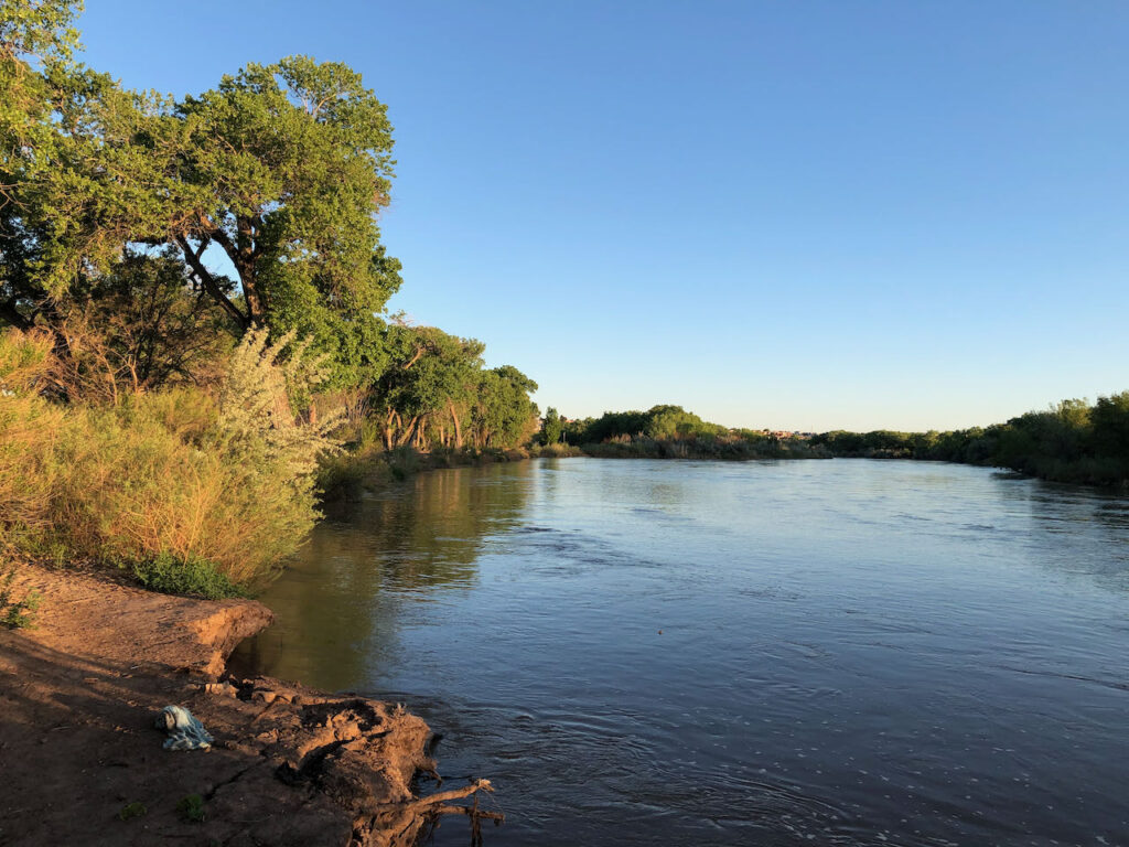
Alameda Lateral, Albuquerque, New Mexico, 2020, by John Fleck

I’ve driven by the spot in the picture a jillion times in the 30 years I’ve lived in Albuquerque, and never noticed the ditch squeezed between #1 Plumbing and Air and the Chevron station on the corner of Edith and Candelaria.

My latest pandemic bike riding project involves scouring GIS data from the Middle Rio Grande Conservancy District, the irrigation district in our part of the Rio Grande Valley, in search of abandoned ditches. The last few weekends my friend Scot and I have been piecing together the remnants of the Barelas Ditch south of downtown. This weekend we turned our attention to the Alameda Lateral, which used to irrigate the east side of what we call Albuquerque’s “North Valley”.

The air was smoky today, so it was a perfect day for the sort of lazy stop-and-go riding needed to find traces of old ditches – folded up paper maps with scribbles in my pocket along with my oatmeal cookies.

MRGCD Alameda Wasteway control structure

At the spot where I took the picture, the Alameda is just a wasteway, no irrigation water because no irrigated land “downstream” of the trash rack in the picture. A block or so downstream, it’s completely underground, but there’s an incongruous irrigation system control structure flanked by busy street, apartment complex, and construction company equipment lot. You can’t just plug an irrigation canal, you have to have a way to let the water drain out the bottom end. So whenever the Alameda downstream from here was formally abandoned, they buried a wasteway conduit to carry what was left over to the big open air “Alameda Interior Drain”, one of the most visible water features in this part of the North Valley.

Scot and I spent a bunch of time trying to find the upstream bits of the canal (our Strava GPS from the ride is hilariously squiggly), riding up and down the neighborhood streets. A lot of it is underground, passing beneath the light industrial stuff that long ago displaced the marginal agriculture that used to scratch by in this valley.

My GIS skills aren’t great, but here’s my attempt at showing this segment of the ditch:


Six Colorado River Basin States to Interior: Don’t Allow Utah to Blow up Basin Collaboration

The six Colorado River Basin states that do not have the letters “U-T-A-H” in their names just sent a remarkable letter to Secretary of the Interior David Bernhardt with a plea – don’t let the rush toward federal approval of Utah’s proposed Lake Powell Pipeline blow up the Colorado River Basin’s framework of collaborative rather than confrontational problem solving:


The six-state letter, the product of intense discussions in recent weeks among the states (including the one with “U-T-A-H” in its name) takes great pains to point to an important historical norm in Colorado Basin governance – states don’t mess in other states’ internal water use decisions. But in asking to move Upper Basin water to a Lower Basin community, Utah has crossed a line that the other states simply couldn’t let pass.

The full letter is worth a read.

How municipal water conservation is keeping the Rio Grande through Albuquerque from going dry

Rio Grande at Albuquerque’s Central Avenue Bridge, Sept. 6, 2020

One of the traditional “tragedy narratives” of western water is the idea that thirsty cities are draining our rivers. But in two of the last three years, precisely the opposite has happened here in Albuquerque.

We’ve been limping along on a very bad year on the Rio Grande, with some of the lowest flows through Albuquerque that we’ve seen in a while. And the limping will continue. But with irrigation water in storage just about gone, an agreement is taking shape that will use an unused chunk of Albuquerque’s imported Colorado River water to keep the Rio Grande from drying through Albuquerque in coming months.

This is possible because Albuquerque’s water conservation success has left it with more water rights than it currently needs, including water we import through the San Juan-Chama project, a transbasin diversion that brings Colorado River water through tunnels beneath the Continental Divide. Some of that, now sitting in storage in reservoirs up on the Chama, will be released in coming weeks to maintain flows in the river here in town.

A similar deal in the very dry summer of 2018 also used some of Albuquerque’s unused Colorado River apportionment to keep the Rio Grande wet.

To be clear, this isn’t a charitable contribution on Albuquerque’s part. As I understand the deal, three government agencies with a shared interest in keeping the river wet – the Middle Rio Grande Conservancy District, the New Mexico Interstate Stream Commission, and the U.S. Bureau of Reclamation – are paying the Albuquerque Bernalillo County Water Utility Authority for the water.

Also to be clear – the environment and our community’s cultural values around a flowing river in our midst will not be the only beneficiary. After what water managers call “system losses” – the trees and the shallow aquifer using a share of the water as it wanders downstream – some portion of the water will arrive at an MRGCD dam south of Albuquerque, where it can be diverted for use by farmers south of town.

Also to be clear – absent upstream dams, which held back a bit of the high spring flows for use over the summer, the Rio Grande through Albuquerque would have this summer long since been dry. This is such an altered system that in a year like this, it’s only human water management that is keeping anything flowing here at all.

Also to be clear – the only reason we’ve got this extra water at all is because we divert large quantities away from the Colorado River, which has problems of its own.

But it’s intriguing to see the traditional narrative turned on its head – water available for the environment because a city has more than it needs.


San Diego’s puzzling pursuit of a big new pipeline to the Colorado River

I’m puzzling over the San Diego County Water Authority’s pursuit of a new Colorado River pipeline.

I’ve been puzzling for a while, given a that it would be really expensive and that a really big pipe (aqueduct) already exists to carry the water to San Diego. My puzzlement was goosed by a report that surfaced last week at a board meeting of one of its member agencies suggesting that the general managers of agencies representing the majority of the Water Authority’s actual water-using member agencies don’t seem to want it.

The puzzle

In 2018, the San Diego County Water Authority did something striking, given the water management community’s tendency toward inflated future demand projections. It calculated something it called a “demand reset”, involving a fresh look at demand projections published just two years earlier.

rethinking San Diego’s water needs

Demand calculations published in the agency’s state-mandated Urban Water Management Plan, the “demand reset” analysis found, had inflated near-term water demands (water needed by 2020) by 9 percent.

So how has the new “demand reset” analysis held up? Actual water use in 2019 was 14 percent lower than the projection made in 2018, just one year earlier.

To be clear – the new study, done out of fears that the last study had overestimated demand, itself overestimated demand.

This has been going on for a while. Since its 2002 peak, total San Diego County Water Authority use has declined by 27 percent, even as the county’s population has risen by 15 percent. See decoupling.

I was grinding through these numbers as I puzzled over the San Diego County Water Authority’s scheme to build a new pipeline across the desert to carry its supplies of Colorado River water – ~280,000 acre feet a year of water it got through various agricultural efficiency projects in Imperial Valley.

That water currently is delivered via exchange agreement through the existing Metropolitan Water District Colorado River Aqueduct. So San Diego already has a way to get the water. But an arcane legal and financial and cultural feud (c’mon L.A., know you hate the Padres) between the San Diego County Water Authority and the Los Angeles-based Metropolitan Water District of Southern California has led the San Diego County Water Authority to pursue a pipeline of its own, so that it would no longer be beholden to Met.

I’ve been careful in my language here to talk about “the San Diego County Water Authority”, rather than “San Diego” writ large. The Water Authority is a creation of state law that serves as a water wholesaler and system integrator across territory served by 24 member agencies, large and small. As is often the case with regional water authorities of this sort, its board of directors is made up of representatives of each of the member agencies.

Conceptual map for possible routes for a new San Diego pipeline to carry Colorado River water

In the summer of 2019, on a trip to Imperial Valley to gather stuff for a new book I’m writing hoping to start working on again when the pandemic fog clears, I heard a fascinating presentation about the project from San Diego County Water Authority Assistant General Manager Dan Denham to the Imperial Irrigation District board. Denham laid out the Water Authority’s basic argument – that with anticipated increases in the cost of getting its water through the existing Metropolitan system, it makes sense for the Water Authority to consider building its own pipe. In a net present value calculation, the Water Authority has been arguing, it would be cheaper. (The minutes are here if you’re curious, the questions were interesting.)

Here’s the fresh part of puzzle.

The idea that this is cost effective in the long run, being pushed hard by San Diego County Water Authority management, does not seem to be shared by the authority’s member agencies. 18 of the 24 member agencies, representing by my calculation 89 percent of the Authority’s water use, went out and hired their own consultants to take an independent look at the numbers. Their conclusion (which surfaced last week at a meeting of the Vallecitos Water District board, the report starts on pdf page 82):

The Draft Study’s finding that the project is economically competitive with other supply and transportation options is not reasonable. We find the project to be substantially more costly than other options.

Dueling consultants’ reports followed, and I’m not going to wade into the question is which team is right. I will note, rather, that the managers of the 18 water agencies (including the City of San Diego, by far the region’s largest water user) were sufficiently concerned about the numbers coming out of the Water Authority that they went out and hired their own consultant.

San Diego’s dream of its own Colorado River pipeline has been around since the beginning of water development in the region. In its current incarnation, the project has been at least somewhat actively pursued since 1998. So it’s probably never going to go away. But I’m adding this to my “yeah, but it also probably will never be built” list.

(H/t to Voice of San Diego’s Ry Rivard for his work on this topic over a number of years.)

Comments on the Lake Powell Pipeline

The written version of remarks delivered by Eric Kuhn at the Aug. 25 Western Resource Advocates webinar on the Lake Powell Pipeline, featuring Eric, WRA’s Bart Miller, and Alice Walker, attorney for the Kaibab Band of Paiute Indians.

PRESENTATION COMMENTS ON THE LAKE POWELL PIPELINE

ERIC KUHN 8/25/2020

When John Cyran asked me to participate in this panel, I said yes with two important caveats.  First, I’m on this panel as an author/river nerd that has studied the history of the development of the Colorado River (it’s definitely a passion of mine).  As a retiree I no longer have any official affiliation with any entity on the river (I’m an unsigned free agent).  I’m not representing the views or providing a perspective of my former employer, the River District and certainly not Colorado, the state I’ve lived in for the last 40 years. Second, while I understand the perspectives of Bart and Alice, my objective of being on this panel is neither to oppose nor support the project.

What I want to do is briefly describe some of the related Colorado River Compact issues and complications and discuss the future of the Colorado River.  As most of you may know, the physical source of the supply for the LPP is Lake Powell, located in the Upper Colorado River Basin (the legal source may actually be Flaming Gorge Reservoir), the location of use, the St. George area is in the Lower Basin.  I do not consider this complication, which I’ll describe in detail, as a fatal flaw. The reality is that the Lake Powell Pipeline (if built) is not the first, nor will it be the last project, to move water from the Upper Basin to the Lower Basin.  My primary concern, as a student of the Colorado River, is the future governance of the Colorado River. How do we best make decisions for the basin and the river, given the challenges we’re facing from climate change, the full use/overuse of the available supply, and the competition for the available water among the basin’s agricultural, urban, recreation, native Americans, and environmental uses.

The 1922 Colorado River Compact negotiators could not agree on an approach to apportioning the consumptive use of the river’s water among the seven basin states. Instead, as a compromise, they apportioned the use of the water among two basins with the dividing line as Lee Ferry, one mile downstream of the confluence of the Colorado and Paria Rivers (Lee’s Ferry).  As a “quirk” of defining the basins based on the drainage areas above and below Lee Ferry, three states ended up with lands in both basins.  Arizona has lands in the Upper Basin, primarily on the Navajo Reservation, that drain above Lee Ferry, and Utah and New Mexico have lands in the Lower Basin. In New Mexico it is the headwaters of the Gila and Little Colorado Rivers.  In Utah, the Virgin River and Kanab Creek drainages join the Colorado River below Lee Ferry, and thus, the St. George area is in the Lower Basin.

The 1922 compact divided the water up three ways: 8.5 million acre-feet of beneficial consumptive use exclusively for the Lower Basin, 7.5 million acre-feet exclusively for the Upper Basin, and a surplus (4-5 million acre-feet) for Mexico and future apportionment. This three-way split was based on the assumption that the total supply of the river (at the international boundary with Mexico, NOT Lee Ferry) was over 20 million acre-feet per year (a faulty assumption even before the compact was ratified – see Science Be Dammed). I believe that by the use of the term “exclusive” the commissioners meant that water apportioned for the Upper Basin was only for the Upper Basin (as defined by the compact) and not available for use in the Lower Basin.  In fairness to Utah, both the 1922 compact and the Upper Colorado River Basin compact include provisions that provide that states control the use and distribution of water within their boundaries which, Utah argues, means that it can its Upper Basin apportionment to its portion of the Lower Basin.

However, I strongly believe that for the first 80-90 years of the compact, if one were to ask about every compact expert and state water official if the 1922 compact allowed water apportioned to the Upper Basin to be used in the Lower Basin (or vice versa), the answer would have been HELL NO! Then came the need to solve real water supply problems and the Navajo-Gallup Pipeline, a project which is now mostly built and takes water apportioned by the Upper Colorado River Basin Compact to New Mexico and delivers it to the Gallup area located in the upper reaches of the (normally dry) Little Colorado River drainage, a Lower Basin tributary.  As a part of its water rights settlement with the Navajo Nation, New Mexico chose to use a portion of its Upper Basin apportionment for this much needed project.  After discussions led to a consensus approach among the seven basin states Congress authorized the Navajo-Gallup Pipeline. This approach, I believe, is consistent with the intent of the 1922 compact (Article VI).

As I mentioned earlier, I view this forum on the LPP as an opportunity to raise a number of concerns I have for the future of the Colorado River (I’m not suggesting that these problems are all on the back of the LPP).  Simply put, the Colorado River is shrinking due to climate change, and most, if not all, of the available science suggests this shrinkage will continue for decades into the future.  Under the “law of the river” we legally apportioned 17.5 million acre-feet (16 under the 1922 compact and 1.5 for Mexico under the 1944 treaty) based on an assumption of 18 million acre-feet of supply at Lee Ferry (about 18 in total). By the 1940s for the Mexican Treaty and the Upper Basin compact we thought the supply was 16 million acre-feet (18 in total). By the 1960s and the authorization of the Central Arizona Project, our best estimate of the long-term average natural flow at Lee Ferry had dropped to about 15 million acre-feet per year.  Since the Upper Basin compact apportions to each State of the Upper Division a percentage of the water available to the Upper Basin under the 1922 compact, determining how much water is available is not a simple manner. NOTE: there are differing interpretations of the Upper Basin’s compact commitments. With the storage we have in place (Lake Powell & others), considering the variability of the river, and meeting downstream compact commitments, 15 million acre-feet (on average at Lee Ferry) provides about 6 million acre-feet of usable water for the Upper Basin, a number that many in the Upper Basin stubbornly cling to (or perhaps wish for).

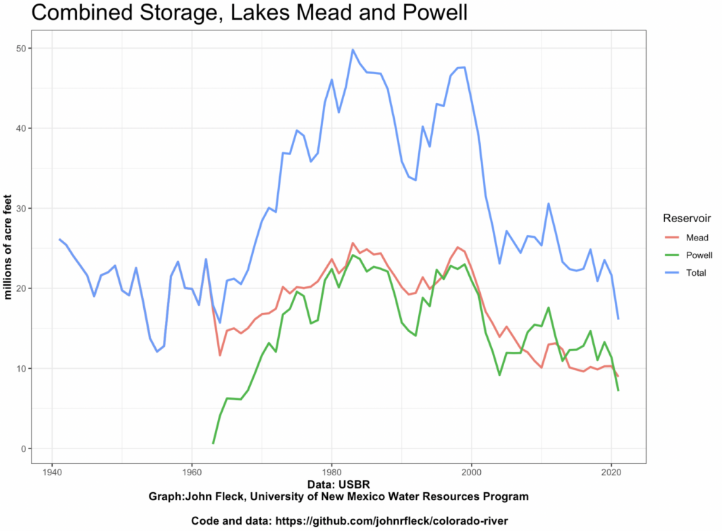
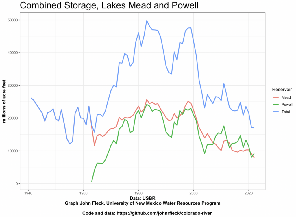
But that was before we understood the impacts of climate change. Based on the last 21 years, the river’s natural supply, before dams and diversions remove water for human use, has been about 12 -12.5 million acre-feet at Lee Ferry, NOT 15.  Because of the continuing impacts of climate change, the 12-12.5 million acre-feet today could easily be less than 11 million acre-feet per year within 50 years. A project like the LPP has a useful life far longer than 50 years.  With 12.5 million acre-feet of natural flow at Lee Ferry, the Upper Basin’s usable water is about 4 – 4.25 million acre-feet – about what we’re consuming today.  If regional temperatures continue to rise reducing the river’s natural flow at Lee Ferry by another million acre-feet AND the Upper Basin’s compact commitments remain unchanged, the Upper Basin could be overusing its available supply by a million acre-feet per year.  NOTE: As a basin, our annual consumptive use is about 14-15 million acre-feet (including Lower Basin tributaries).  We’ve balanced the books by drawing down Lakes Mead and Powell. In the recent few years, the system has been about in balance as the Lower Basin has reduced its use of Lake Mead water from over 8 million acre-feet per year in 2001 to most recently about 6.8 million acre-feet per year.

Simply put, the Upper Colorado River Basin is now caught in a vise.  We have fixed commitments under the 1922 compact and a declining supply of water above Lee Ferry. Yet, many are still operating under the illusion that the Upper Basin has “unused” entitlement.  As I noted earlier, the LPP is not the first, nor will it be the last proposed project to move water from the Upper Basin to the Lower Basin.  With the closure of the Navajo Generating Station, Arizona and the Navajo Nation are discussing options for the disposition of the 34,000 acre-feet of Upper Basin water that was once used by NGS (Arizona’s total UB apportionment is 50,000 acre-feet).  Will this water also be transferred for use in the Lower Basin? If it’s appropriate for Utah to decide it can use water apportioned for the exclusive use in the Upper Basin in the Lower Basin, what is to prevent Arizona from making the same decision?  By intentionally ignoring the geographic limitations carefully written into the 1922 compact by its negotiators, are we cracking the door open for speculators to purchase Upper Basin agricultural lands, dry those lands up, then deliver the consumptive use to the Lower Basin? At a time when the water apportioned to the Upper Basin is slowly going away, does it make sense to move water apportioned for its use to the Lower Basin?

These are not simple problems. What I hope will happen is that the discussion of the LPP will lead to a more general discussion of how to address the impacts of climate change on the Upper Colorado River Basin. As a former water manager, I want to acknowledge that, if I were in the shoes of the manager of the Washington County Water Conservancy District, I would be very nervous about having one source of supply, the Virgin River drainage.  As a southern and relatively low elevation watershed, the Virgin River is especially prone to drying from climate change.  To address the impacts of climate change on the Upper Basin I believe we should consider four major objectives: aggressive conservation (every drop of water counts), a plan to operate existing infrastructure and build new infrastructure designed to accommodate the deep uncertainty created by climate change, a basin-wide approach for sharing the risk of climate change among the Upper Basin, Lower Basin, and Mexico (this should be our number one goal in the negotiations of the post-2026 river management guidelines), and reducing greenhouse gas emissions.

Unlike the Lower Basin, the Upper Basin has been successful in maintaining a unified approach on Colorado River issues. We did so for the negotiations of the 1922 and 1948 compacts, the Treaty with Mexico, the Arizona vs. California Supreme Court litigation, and for all of the major federal development and environmental laws that have shaped the Colorado River.  It is now past time to do so on climate change.

Lower Basin use of main stem* Colorado River water dropping to levels not seen since the 1980s

Bending the curve back down

A friend last week pointed out something remarkable. Arizona, California, and Nevada are forecast this year to use just 6.8 million acre feet of their 7.5 million acre foot allocation of water from the main stem of the Colorado River. And that’s not just a one-off.

Under “Tier Zero” of the Colorado River Basin Drought Contingency plan, the states are allowed to take 7.3 million acre feet of water, but from 2017 to 2020, the Lower Basin states’ average has been 6.8 million acre feet. The last time the four-year average was that low was 1984-87.

With a release of just 8.23 million acre feet from Lake Powell this year, Lake Mead is nevertheless forecast to end the water year up a foot over last year. For a while, I and others have been arguing (see here, for example, for some trouble I caused myself when arguing thus) that the Lower Basin has only been able to stabilize Lake Mead on the backs of excess releases from upstream, the 9 million acre foot releases under the terms of the 2007 interim guidelines.

Are we moving beyond that?

* As my collaborator Eric Kuhn frequently notes, these numbers do not include the use of tributary water within the states of the Lower Basin, by which we mostly mean Arizona.

Sources: USBR forecast for 2020 water use, USBR water accounting reports

Visualizing Low Flows on New Mexico’s Rio Grande

Figure 1: Low flows on the Rio Grande, log scale

Figure 2: Low flows on the Rio Grande, linear scale

When there’s a lot of water in the Rio Grande, an extra 25 cubic feet per second is a “meh”. But right now, it matters a great deal.

Figure 2 above is the output of a script I use to track river flows (code here for those inclined). You give it a USGS gauge number and it downloads and plots the data. For my intuitions, the second graph is normally far more useful.

But at the extreme low flow numbers we’re seeing right now (lowest for this point in the summer since 1981), the log scale seems more useful, eh?


McCann: McSally’s bill to restart the Yuma Desalting Plant “nothing more than a PR stunt”

From the comments, but worth elevating to a post so folks it doesn’t get lost – Tom McCann on Arizona Sen. Martha McSally’s bill to restart the Yuma Desalting Plant:

McSally’s bill is nothing more than a PR stunt–a way to appear to be doing something on the Colorado River without any risk of it actually happening. If she had talked to anyone knowledgeable about the Yuma Desalting Plant (doubtful), she would know that the plant cannot be operated without extensive repairs and capital improvements, which Reclamation estimated nearly a decade ago would cost anywhere from $160-450 million, plus another $25-40 million in annual operating costs. That’s never going to happen. The YDP, as originally designed and intended, is dead.

But there are other, far less expensive ways to satisfy the US obligations under the 1974 Salinity Control Act and Minute 242, conserve water in Lake Mead AND preserve the environmental values of the Cienega. In 2013 we described one such alternative: construct a pipeline to transport the 100KAF Wellton-Mohawk drain water to Imperial Dam where it would be mixed with roughly 6MAF of Colorado River water that passes that point every year, eliminating the need to release an additional 100KAF from Mead every year. At the same time, the US could increase pumping from the 242 well field and dedicate 50 KAF/yr of that water to the Cienega. The total cost of that alternative was estimated at around $100 million, which would be funded by non-federal parties in return for ICS credit, with an annual operating cost of about $4 million–less than Reclamation spends today to NOT operate the YDP.

Unfortunately the proposal never got any traction because entities that take their Colorado River water from Imperial Dam objected to the 20-30 ppm expected increase in salinity there, despite the fact that (1) 20-30 ppm is within the normal variation of salinity at Imperial and (2) the salinity at Imperial today is far less than it was in the past (less than 700 ppm in recent years), largely through the work of the Title 2 Salinity Control Program to which those water users do not contribute.

Many thoughtful comments on my musings on California groundwater regulation and agricultural land value

Many thoughtful comments on yesterday’s breakfast musing on the implications of rising California ag land prices, here and over on the twitter, provide yet another reminder that my readers are far smarter than I am about this stuff.

The most important point, which quite a few people made, is that a single California number hides a lot of variability – down some places, up in others, depending on regulatory framework, estimates of political power, availability of surface and/or groundwater, recharge potential (but see OtPR below).

Andrew Ayres at UCSB (Click for full thread from an actual economist!):

These USDA numbers aggregate over a diverse landscape in California, some of which may not be subject to #SGMA. Reports from ground-zero for #SGMA, the San Joaquin Valley, tell a little different story.

In some critically overdrafted basins, appraiser reports show land that only has groundwater access selling at depressed prices already, relative to district lands. Sales slowing, prices lower….

All in all, I think too early to reject that the market is doing what markets do: translate (albeit perhaps limited) knowledge from numerous disparate parties into price signals that reveal information & can direct action.

Michael Hanemann (another actual economist):

There is a flattening in California’s irrigated land value at the very end of the data (2019 onwards).

SGMA did not become a reality until very recently — as you know the actual SGMA plans were to be filed by Jan 31 of this year.In the development of the GSA plans, there was a large amount of magical thinking (we will find a source of water with which to replace the groundwater overdraft…).

Moreover, the political pushback against SGMA also began to appear in public this Spring. So, the market may now be showing some acknowledgement. of SGMA.

Great question from Mark Lubell at UC Davis:

It is interesting think about how SGMA will affect value. Water supply may become less certain=acreage abandoned, reduced value. But then acreage with water becomes scarce=increased value.

Mike Antos:

The key question is whether the market has decided to price in water efficiency, or if it has decided power and money will figure a way around the new system?

OtPR:

I’m pretty sure that comparing acreage inside GSAs and in white areas would show the price for land going in different directions. The price of land in GSAs may also be based on an overestimate of potential recharge.