The Distribution of Green

Rio Grande in central Albuquerque at sunup

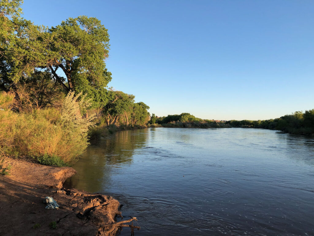
Rio Grande, Albuquerque, New Mexico; 1,430 cubic feet per second, May 6, 2021

Ima give this a fancy sciency-sounding patina: I walked a transect today across the ribbon of green the Rio Grande provides through the heart of Albuquerque.

I’m trying to think through what I have come to understand as the fundamental choice we face as climate change depletes the river.

We will have less green:

  • Which green do we save, and which must we give up?
  • How do we, as a community with different values, institutions, and interests, make the necessary choices?
  • What are the roles of collaboration, law, and raw political power?

In my journalism and academic work, I’ve been caught up for a long time in some categories that, in Albuquerque, seem increasingly unhelpful – “agriculture”, “municipal use”, “the environment.” The categories line up pretty nicely with the government agencies, the rules and regulations, we use to manage the water resource, along with the conceptual categories of “natural” and “unnatural”.

But they’re not quite working for me right now.

A morning at the river

For a short shining instant, the Rio Grande through Albuquerque is up. We’re all scared shitless about the doom to come this summer as the water runs out, but in the dawn light today the cottonwoods were shimmering as I walked one of my favorite paths north of Albuquerque’s old Route 66 bridge.

I was too wrung out from stress-riding my bike this week, and stress-zooming my job, so I decided to skip my usual morning ride to the river. Instead I gulped the second cup of coffee and drove down to one of my favorite bike ride destinations along the Rio Grande. I realize gulping coffee and scarfing down my breakfast in order to jump in a car and hurry somewhere to relax is cognitive dissonance writ large, but I made it by sunup and the water, and the green, were a salve.

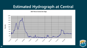
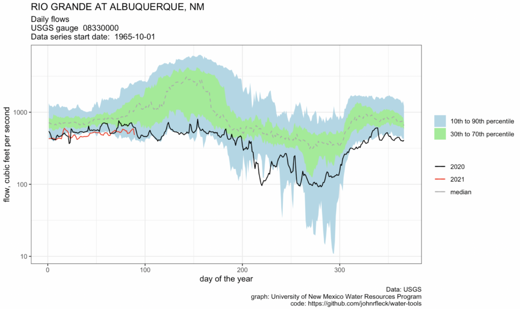
Projected Rio Grande flow at Albuquerque’s Central Avenue Bridge. USBR, April 2021

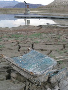
At the bridge, the river’s flowing 1,430 cubic feet per second as I write this, which will mean nothing to most of you but to me means a lot. The Bureau of Reclamation’s Annual Operating Plan, presented at a mid-April f’ing Zoom call (pdf here, technically I think Microsoft Teams because Feds, but still f’ing) projected decent flows through early June before the bottom drops out. Sitting on a bench by the river (see picture above) I could hear the drone of Route 66 cars in the background and the ripply sound of water at my feet. Enjoying it while I can.

A half mile north of the Central Avenue Bridge, the Atrisco siphon this morning was pushing out 80 cfs into the Arenal Main and the Armijo Lateral, a pair of distributary canals that substitute in this coupled human and natural system (we actually call them “CHANS”) for the role a braided river channel might have played in spreading life across the valley floor. Again, not a meaningful number unless you live in the South Valley, in which case it’s the lifeblood of your part of the CHANS.

Categories – unhelpful

My old categories – “agriculture”, “municipal use”, “the environment ” – aren’t quite connecting up for me now with the question I see about the distribution of green.

What we call the “bosque”, the riparian strip between the levees, is profoundly “unnatural”, the vestige of a flood control system that robbed the valley floor of high spring runoff but left a single strip of land through the city with a high enough water table for phreatophytes to thrive, at least for a time. Unnatural, whatever, I value it enormously, as do the black-headed grosbeaks who were the highlight of the bird list I made on my morning walk.

For the saltgrass marshes that used to spread across the valley floor, we’ve substituted small-parcel irrigation of land around houses – the word “agriculture” is right, but misleading. This is not Iowa, nor the Imperial Valley. Thousands of people do this, one at a time, and net cash farm income here is negative. But ah, the green. They’re clearly doing it for other reasons that we’ve not been very good at incorporating into our water policies.

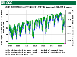
Just up the road, in an area we call “Los Griegos” that’ll likely be central to the next book, a city well field drilled in the 1950s still pulls water from the aquifer for use in the urbanized part of the city. These days its use is minimal, but with the community’s water utility in “drought reserve” operations last year, the Griegos field pumps pulled 3,000 acre feet of water from the ground for neighborhoods like mine. What water I use indoors ends up, via the wastewater treatment plant, back in the river. What water I use outdoors is spreading more green. As you can see from the graph, the aquifer in general has been rising in recent years thanks to Albuquerque’s success both in conservation and in shifting to use of imported surface water, but last year’s drought was a clear setback.

And it is worth remembering that the imported water (Colorado River Basin transbasin diversion) just means less green in that basin.

Sorry, Colorado River Delta. It’s all about shifting the green around.


The next steps in “my semi-charmed life of the mind”

tl;dr

I’m stepping down as director of the UNM Water Resources Program at the end of summer semester to write another book.

longer

When I was happily toiling those many years as an inkstained wretch, I had secret fantasies of leaving newspaper work to spend my waning years on the campus of the University of New Mexico. It’s a short bike ride to campus, which has trees and libraries and people thinking slowly.

Building another pirate ship

I loved what newspaper work gave me – Michael Hirschorn called it “a certain kind of quasi-bohemian urban existence for the thousands of smart middle-class writers, journalists, and public intellectuals who … live semi-charmed kinds of lives of the mind.”

The publisher paid me to spend my days learning all the things – reading, calling people to explain things to me, trying to figure out what was the most important stuff, then typing it up so people could stay up all night printing thousands of copies of whatever I wrote and then driving around and throwing it on people’s driveways.

It is impossible to oversell how sweet a gig that was for a curious guy with good typing skills.

But over time the model was a poorer and poorer fit. As I wrote back in 2016 after leaving it:

It was a decent model for a long time. But the institutional constraints were substantial. For me, it was the form of the newspaper story. It was ill suited to the depth and complexity of the issues I was trying to understand – demanding of narrow story lines and uncomfortable with uncertainty.

So I quit newspapering to w r i t e  a  b o o k, in the process stumbling into a side hustle teaching and working with students in the University of New Mexico Water Resources Program. The then-director Bob Berrens, who is clever, gave me an office on campus, a title (I was for a time the WRP’s “Writer in Residence”), and the all-important library privileges. Slowly, the secret fantasy became reified. I commuted by bicycle to the leafy campus, wandered the shelves of its many libraries, engaged in hours of conversation with smart colleagues.

I slowed my thinking down, and the result was the best writing of my life.

In the summer of 2016, UNM’s Department of Economics invited me to join its faculty, and UNM Dean of Graduate Studies Julie Coonrod appointed me the director of the University’s Water Resources Program.

The job has exceeded the idle fantasies of my younger years. So much fun to teach, and learn from, UNM Water Resources Students. So much fun to spend my days on a university campus with all the thinking and libraries and trees.

But as I began seriously contemplating The Next Book, I had to conclude I no longer had the mental energy to continue as the WRP’s Director. “You may be actually writing only two or three hours a day,” John McPhee wrote in Draft No. 4, “but your mind, in one way or another, is working on it twenty-four hours a day.” This is for me a joy, but it also is the central responsibility.

I did manage to write another book while in the job, riding the intellectual coattails of my brilliant co-author Eric Kuhn. But it was hard. Being WRP director presented my poor aging brain with competing loyalties – the program’s needs grabbing spare cycles from my idle brain.

I had to laugh through my enduring imposter syndrome when Dean Coonrod today announced the finalists to take over the program. All four are on my list of “smart people from whom I’ve learned everything I know about water.” For the program, which I love, exciting times are ahead.

For me, I’ll have more to say as we firm up my post-directorship plans. I’ve got some super fun ongoing work with a number of students that I’ll be seeing through, and we’re looking at the possibility of a continued role for me at the university, doing work that dovetails with the book.

As McPhee says, twenty-four hours a day. I’m really looking forward to that semi-charmed life.

The April 2021 24-Month Study was a Shocker, but is it too Optimistic?

By Eric Kuhn

The release of last week’s Bureau of Reclamation 24-month study felt like very bad news for the Colorado River (See Tony Davis for details.). But a careful reading of the numbers, and an understanding of the process through which they are developed, suggests things are likely even worse than the top-line numbers in the study.

The problem: the assumptions underlying the study do not fully capture the climate-change driven aridification of the Colorado River Basin. Taking climate change into account, it is easy to find evidence lurking in the report to suggest that, in addition to problems for Lake Mead, Lake Powell could drop below elevation 3,525 in 2023, a level that is troublingly close to the elevation at which Glen Canyon Dam could no longer generate hydropower.

The 24-month studies are used to project out two years of monthly inflows, releases, storage levels, and power generation from the system’s large reservoirs in both basins as well as diversions by the large water users on the river below Lake Mead, especially the Central Arizona Project and the Metropolitan Water District of Southern California. Reclamation releases a “most probable” study on a monthly basis as well as “minimum probable” and “maximum probable” studies approximately quarterly. These studies are important because they are used to make critical decisions under the 2007 Interim Guidelines and both the Upper and Lower Basin Drought Contingency Plans (DCPs).

For the first year, Reclamation uses “unregulated” runoff forecasts generated by the Colorado Basin River Forecast Center (CBRFC) model. Unregulated inflow is not the same as natural inflow. The CBRFC does its best to adjust the forecasts for upstream diversions and for the many reservoirs that are not included in the 24-month study model. Inflow forecasts for the second year of the 24-month studies are not based on the CBRFC model. Instead, Reclamation, in consultation with CBRFC, uses statistics from the past and its judgment. Running the 24-month study model then simulates the operation of the upstream reservoirs such as Navajo, Blue Mesa, and Flaming Gorge, turning unregulated inflow to Powell into “regulated” inflow. For example, from the April ‘21 most probable study, the WY 2021 unregulated inflow to Powell is 4.897 MAF, regulated inflow is 4.908 MAF. These numbers are close, but in WY 2020 regulated inflow exceeded unregulated inflow by about 700,000 acre-feet.

The media buzz over the April 24-month study primarily focused on the projected Tier 1 shortage for the Lower Basin in 2022 – an event that is newsworthy, but one that also was totally expected. Perhaps more interesting and alarming is what the 24-month studies suggested for 2023. As pointed out by John in his recent blog, the most probable study shows two years of 7.48 MAF releases from Lake Powell, Lake Mead elevations on the cusp of a Tier 2 shortage in 2023, and by inference, Lake Mead dropping to a level of about 1035’ by the end September 2023, which by implication would trigger a third straight shortage year and California’s possible participation sharing shortages under the Lower Basin DCP.

For Lake Powell, the most alarming results come from the minimum probable study, not the most probable study. Under the minimum probable inflow forecast to Powell, which, in theory, represents an unregulated flow that would be exceeded in 90% of years, by March of 2023 Lake Powell drops well below the 3525’ target that would trigger supplemental releases from the upstream CRSP reservoirs under the Upper Basin DCP. There is also a real possibility that Lake Powell could end up in the Lower Elevation Balancing Tier. If this happens, the April minimum probable study shows that Lake Mead gets more water in the first six months of WY 2023 than under the most probable study.

The term “minimum probable” implies an outcome that is very unlikely to occur, therefore, why should we be that concerned? My answer is that given the abundance of recent science concluding that the Colorado River Basin is not in a classic drought, but rather, it is undergoing aridification where the flows seen in the last two to three decades may be the new abnormal and may continue to decline (see for example Overpeck and Udall, and the latest Utah State Future of the Colorado River white paper White Paper). The April studies show a most probable Powell unregulated inflow for WY 2022 of 9.998 MAF and a minimum probable inflow of 7.208 MAF. For comparison, the mean unregulated annual inflow to Lake Powell over the last ten years, including WY 2021, was only 8.04 MAF and five of the individual years; 2012, 2013, 2018, 2020, and 2021, were well below the 7.208 MAF. The average of those five dry years was 5.08 MAF, over two MAF less than the assumed minimum probable inflow for 2022. If you take the record back to 2000, the results are similar. In 11 of 22 years, unregulated inflow to Lake Powell was less than 7.2 MAF/year.

Based on the last 20-plus years and the recent science, I conclude that both the minimum probable and most probable 24-month study year two unregulated inflows to Lake Powell are overly optimistic. The likelihood that in the next few years Lake Powell storage will fall below the 3525’ target or even the minimum power elevation (3490’) and that Lake Mead storage will approach 1025’, the level that triggers the maximum annual cutbacks under the Interim Guidelines and DCP, about 1.4 MAF, is much greater than what is conveyed by these studies.

A few years ago, Reclamation made the decision to begin using a stress test (1988-2018) in addition to the full “natural flow” record (1906-2018) for planning and project evaluation purposes. It may now be time for Reclamation to do something similar with the 24-month studies – base the year two unregulated inflow to Lake Powell on the post-2000 hydrology. This would not change the first-year decisions based on the 24-month study, but would help people in the basin better understand second year risks.

Not drought

From my conversation last week with Drew Kann at CNN:

To Fleck, all of this signals that the reduced flows in recent years are likely not an aberration, but rather a glimpse of the challenges posed by a hotter, drier climate.
“We’re now seeing the model for what the future of Colorado River Basin water use looks like, where scarcity is the norm and drought is not some special short-term thing,” he said. “This is the way of life we’re in now with climate change reducing the flow on the river.”

Lake Mead likely to drop below elevation 1,040 by late 2023

Boulder Harbor, Lake Mead, Oct. 18, 2010

Boulder Harbor, Lake Mead, Oct. 18, 2010

I’m choosing my words carefully here. The “likely” in this blog’s post’s title means “based on my analysis of the Bureau of Reclamation’s current ‘most probable forecast’ Colorado River water supply model runs.”

The Bureau’s current “most probable” modeling suggests that in both 2022 and 2023, the annual release from Lake Powell will only be 7.48 million acre feet. This is based on a provision in the river’s operating rules that, under certain low storage level conditions, the Upper Basin gets to hang onto water in Powell.

The last time and only time we had a 7.48 release, in 2014, Mead dropped 25 feet in a single year. We’ve never had two consecutive 7.48 releases.

The headline in yesterday’s release of the Bureau of Reclamation’s “24-month study” (pdf here) is that Lake Mead will drop below elevation 1,075 at the start of 2022 (triggering a “Tier 1” shortage) and could drop below 1,050 by the start of 2023 (that’s the trigger for “Tier 2”).

Tier 1 next year, which primarily hits Arizona with some deep forced reductions, was no surprise. That’s been obvious for a while, and Arizona’s water leadership has been softening folks up for months. The increasing risk of Tier 2 in 2023, which would mean deeper cuts in Arizona, is sorta new, but it’s been foreseeable.

The real “holy shit” for me in yesterday’s release was the trail of breadcrumbs in the Bureau’s data, pointed out by my co-author Eric Kuhn, leading to a “most probable” Lake Mead drop to elevation 1,035 by the end of September 2023.

To be clear, the Bureau isn’t saying this yet. The latest 24-month study stops at the end of March 2023. But internally, the Bureau runs the model out farther in order to determine, among other things, how much water is likely to be released from Powell in 2023. And the published numbers clearly show – the Bureau’s “most likely” scenario would call for another 7.48 release.

From there, it’s just arithmetic. Based on my analysis of the publicly available numbers, the “most likely” scenario puts Mead at elevation ~1035 at the end of September 2023. This is my math, but my understanding is that it’s consistent with what the Bureau’s internal calculations show.

In my linguistic equivalence here between “likely” and “most probable forecast”, remember that I’m talking about the midpoint in a range of possible outcomes. A run of wet weather could make things substantially better.

But a run of dry weather could make them worse.

The tragedy of the anticommons – we’re good at saying “no”

Cleaning out some old files this morning, I ran across this great quote from Pat Mulroy some years back from a talk about the problems of the Sacramento-San Joaquin Delta. Via’s Maven’s Notebook:

We are very, very good at saying no. We are very, very good at blocking. Anybody can stop anything. What we can’t do or can’t seem to do is find a structure within which to say yes. You will never have enough science, you will never have enough data, but at some point, something has to change.

This applies beyond the California Bay-Delta.

Rio Grande so low I needed to switch to log scale

Flow so low I needed to switch to log scale

I mostly hate log scale in graphs I use for broad communication purposes. It’s just not intuitive.

But I’ve made the switch for this year’s Rio Grande, because the flows are so low that we need the log scale, because at really low flows small changes become big, if that makes any sense. The difference between 50 and 150 cubic feet per second through Albuquerque is hugely consequential for the our river. Best to have a visual display that highlights that.