Coping with Megadrought in the Colorado River Basin

My NIDIS webinar from earlier this week is posted.

Key bits:

  • This year’s “sneaky drought” is a problem.
  • The longer term “megadrought” (climate change-driven aridification) we seem to be in is an even bigger problem.
  • We’ve done some great work in the Colorado River Basin reducing our use of water and building the institutional widgets to cope with scarcity.
  • We have more work to do.

The Birth of the Cool

Santana, Tanglewood, August 1970.

Carlos Santana was born in Jalisco, the son of a mariachi, and grew up in that stateless borderland between Tijuana and San Francisco playing first the violin, then the guitar. There was a breadth to his musical education:

If I would go to some cat’s room, he’d be listening to Sly and Jimi Hendrix; another guy to the Stones and the Beatles. Another guy’d be listening to Tito Puente and Mongo Santamaría. Another guy’d be listening to Miles and Coltrane. To me, it was like being at a university. (source)

There’s an intoxicating moment about 3:30 into this this video of a live performance of Soul Sacrifice at Tanglewood in the summer of 1970.

He’s finished with the opening solo, and wanders off as he hands the song over to the band’s drummers and bass player (a joyous propulsion that is one of the reasons this is one of my favorite versions of one of my favorite songs).

Then he returns, a cigarette hanging from his mouth, now without his guitar, and finds a cowbell to join the rhythm section.

He had just turned 23.

Google Maps said there’s a uranium mine out here. Also, a Wendy’s.

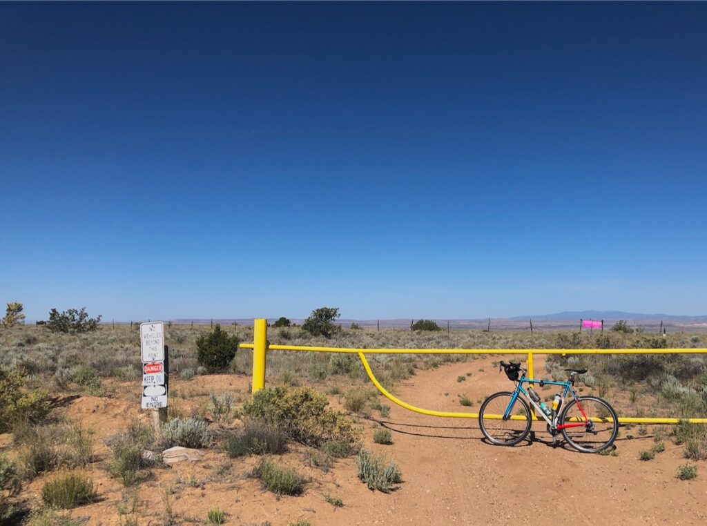
Mount Taylor in the distance, the Rio Puerco Valley in the foreground. Note growing number of water bottles on the bike frame.

In the Time of Pandemic, the ability to refill my water bottles has become an unexpected bike riding constraint. Worst case, if I couldn’t find a drinking fountain, I used to pop into a Kwik-E-Mart and buy a bottle. So, yeah, pandemic, amiright?

I hate those water pack things, and the discomfort of throwing extra bottles in those goofy back pockets on my cycle shirts. So I spent a bit of the afternoon yesterday (which was, I note for the record, a Saturday, if you’re losing track) installing a new bracket on my bike frame so I can carry more bottles.

Thus it was this morning that, with a half gallon of water strapped to my frame and pockets overfilled with Lissa’s ferociously potent oatmeal cookies, I found myself on Shooting Range Road on Albuquerque’s farthest western fringe. The mesas on Albuquerque’s west side take two steps down to the river, and the uppermost bench is largely devoid of human habitation, save the old Double Eagle Airport, the “Compost del Rio Grande” where Albuquerque spreads its sewage solids out to dry (“rich in organic matter, nitrogen and trace minerals“), the city’s emergency winter shelter for people experiencing homelessness, and the shooting ranges.

Mostly its just wonderfully scraggly desert. Even when there isn’t a pandemic, it’s got no Kwik-E-Marts, so I’d never ridden out Shooting Range Road. But now I have cookies and a half gallon of water!

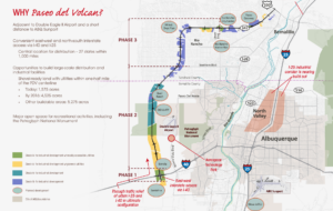
the fading dreams of Paseo del Volcan

Years ago, when I was young and racy, we used to ride out what was then called Paseo del Volcan (because it circles Albuquerque’s west side volcanoes). A few years back, they renamed it “Atrisco Vista” and planned a new “Paseo del Volcan”, a loop rode west of Albuquerque, studded with new housing developments and economic opportunity.

This was a fading idea before the 2008 economic shitstorm, and never unfaded in the years that followed. But lordy we’ve got some nice powerpoints and promotional graphics – “connectivity, access, economic growth“.
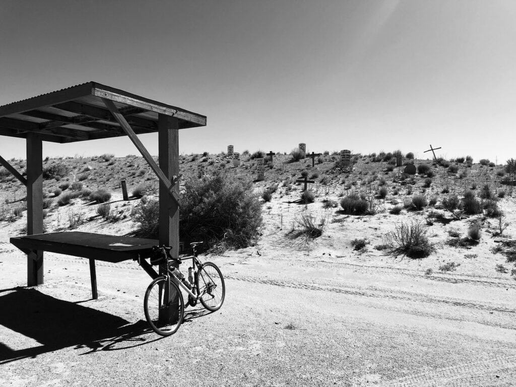
Here Lies Shorty

In the meantime, it’s a great place for Albuquerque to spread its shit to dry, and shoot. I found myself late this morning at the old Wild West action shooting range, complete with old timey cemetery up the hill from the shooting range – closed, sadly, because of the pandemic.

One of the fun things about these long rides along the vast open upper mesa is exploring Google maps quirks. Last month it was the Mystique Food Truck, and today’s outing included a uranium mine and a Wendy’s, out in the middle of the empty. I cannot tell you for sure that there is no uranium mine next to the drying sewage solids (it might be underground, yes?) but there for sure was no Wendy’s here – unless it’s underground too?
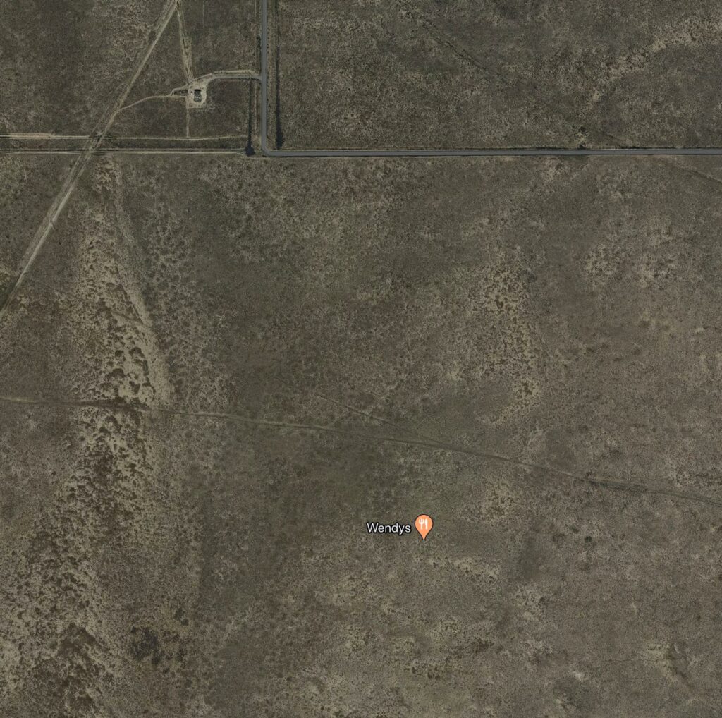
no Wendy’s there

For much of the first months of the pandemic, my mental quirk had been to stare at the cupboards and worry about running out of food. With our offspring handling the grocery shopping for their elders, this really hasn’t been much of a worry of late, so the quirk has transferred to worrying about running out of water on a long bike ride. Two-plus months in, the bike rides are getting a good deal longer, and the weather a good deal warmer.

So I spend hours on line pondering mounting brackets to carry extra bottles, and hunt for the largest bottles. By the time this project is over, I’ll be able to carry a gallon!

There are whole new areas of Albuquerque’s far west side to explore, with nary a Kwik-E-Mart or Wendy’s in sight. The only constraint now will be how many oatmeal cookies I can carry.


2020 Is a Dry Year on the Colorado River. What Happens Next Year Will Be More Important

By Eric Kuhn

This winter’s decent snowfall has turned into an abysmal runoff on the Colorado River, thanks to the dry soils heading into the winter, along with a warm spring. It’s alarming, but given the large amount of storage capacity in the basin and the recent string of good runoff years in the upper Basin, with five of the last six years close to average or better, most of the basin’s water users will not face significant problems this year. Our bigger concern is what happens next year.  Are we headed for a multi-year drought?

Watching the bottom drop out

As of the third week of May, the Colorado Basin River Forecast’s Center’s (CBRFC) daily model is closely tracking the minimum probable forecast inflow to Lake Powell used by the Bureau of Reclamation to prepare its April 2020 24-month study. The 24-month studies are an important decision-making tool under the 2007 Interim Guidelines, which govern the river’s operation.  The 24-month studies show projected monthly reservoir inflows, storage elevations, water deliveries, power generation, and other system data for the next two years. They support critical operational decisions under the Interim Guidelines and associated drought contingency plans, including annual releases from Glen Canyon Dam and shortage levels for Lake Mead water contractors.

declining Colorado River forecast, courtesy CBRFC

Reclamation’s monthly 24-month studies for January – July are based on the CBRFC’s most probable unregulated April-July inflow forecast for Lake Powell and other key Upper Basin reservoirs.  Approximately quarterly Reclamation also publishes 24-month studies based on high flow and low flow scenarios for the remainder of the runoff year – a one-in-ten chance “worst case” and a one-in-ten chance “best case.” This April’s 24 month studies were based on a most probable April – July inflow to Lake Powell of 5.6 million acre-feet, a minimum probable inflow of 4.1 million acre-feet, and a maximum probable inflow of 8.1 million acre-feet.  The CBRFC daily model runs now show about 4 million acre-feet, worse than the April minimum probable forecast. For Water Year 2020 (all 12 months not just April- July), the total unregulated inflow to Powell is projected to be 6.7 million acre-feet, about 60% of average, a little more than half of WY 2019’s 13 million acre-feet, but better than the 2018 drought year of which had an unregulated inflow of 5.5 million acre-feet.

Little impact this year, the potential for big impacts in the future

What does this dry 2020 year mean for the operation of the Colorado River basin, specifically, Lakes Powell and Mead?  Based on the 24-month studies, the answer is not much.  The 2020 operations are already fixed. Glen Canyon Dam will release 8.23 million acre-feet and Lake Mead users will be in a “Tier Zero” shortage under the DCP, requiring a small amount of conservation. Even before the official “Tier Zero” declaration, Lower Basin users were voluntarily saving more than the cuts required under the DCP.  And, even if this year’s runoff continues to decline, it is very unlikely to change next year’s projected annual release of 9.0 million acre-feet from Glen Canyon Dam. Based on the April minimum forecast, at the end of calendar year 2020 Lake Powell is projected to be about 20’ higher than the 3575’ elevation trigger that would result in a reduction of Glen canyon releases to 7.48 million acre-feet in WY 2021.  20’ of elevation in lake Powell at current levels is almost two million acre-feet of storage.  It’s very unlikely that the forecast will lose or be off by that much water.

This good news is the result of last year’s big winter which gave us an above average runoff, charging Lake Powell and the other Upper Basin Reservoirs. The real concern for the basin is not 2020, but 2021 and beyond – will 2020 be the first year of a multi-year drought period?  The last significant multi-year drought in the Colorado River basin was 2012-2013. The second year of a multi-year drought tends to have greater impacts than the first, as water managers try to refill upstream reservoirs, amplifying the multi-year drought impacts on Lake Powell. If 2021 is again dry (below about 70% of average), the storage elevation of Lake Powell could easily drop below elevation 3575’ reducing the annual Glen Canyon Dam release in WY 2022 to 7.48 million acre-feet, pushing Lake Mead into a Tier One shortage. A three-year drought or longer would quickly push Lake Mead downward requiring the large shortages anticipated by the Interim Guidelines and Lower Basin DCP.

Multi-year droughts

Looking at the Bureau of Reclamation’s natural flow data base (NFDB, Jan 2020 version, 1906-2018), two-year droughts are relatively common, three years and longer, less so.  The driest two through four-year periods are shown below:

Two-year periods average annual flow
2002-03 8.163 MAF/year
1976-77 8.318 MAF/year
2001-02 8.447 MAF/year
2012-13 8.708 MAF/year
Three-year periods
2002-04 8.589 MAF/year
2001-03 9.116 MAF/year
2000-02 9.145 MAF/year
1954-56 9.878 MAF/year
Four-year periods
2001-04 9.198 MAF/year
2000-03 9.472 MAF/year
1953-56 10.197 MAF/year
1989-92 10.487 MAF/year

As one can see, many of the driest multi-year periods are associated with the 2000-2004 drought period, which is by far the driest five-year period.  What should concern us is the threat of anthropogenic aridification making multi-year droughts more common.  Three of the four driest two-year and three-year periods as well as the driest four and five-year periods have all happened in the last 20 years, which, not coincidentally happens to include almost all of the warmest years the basin ever recorded in the basin.

Implications for future river management

Being better prepared for future multi-year droughts will be one of the challenges facing the basin stakeholders as they begin to consider the post-2026 river. For example, even though Water Year 2020 has turned surprisingly dry and the basin is under an escalating threat of multi-year droughts, the only parameters used to determine the annual release from Glen Canyon Dam are the projected elevations of Lake Mead and Powell from the 24-month studies. Therefore, the annual release from Glen Canyon Dam for Water Year 2021 will be 9.0 million acre-feet, 750,000 acre-feet more than the normal minimum requirement, putting the Upper Basin under additional risk if next year and beyond are dry. Parameters such as recent trends of naturalized stream flows and regional temperatures, longer-term forecasts, and the consensus messages from climate science are not currently considered.

For the river’s post-2026 operational guidelines, let’s hope that changes.

May 27 webinar: Coping With Megadrought in the Colorado River Basin, featuring me

I’ll be I’ll be yammering about the  Colorado River basin, sneaky droughts, and megadroughts with the folks at NIDIS (the National Integrated Drought Information System):

As the Colorado River Basin experiences 2020’s “sneaky drought” amid a long term pattern that looks increasingly like one of the region’s millennial “megadroughts” that last decades, water managers are working on ways to adapt. Where are we seeing success, and which communities are vulnerable as climate change continues to eat away a river on which 40 million people depend?

Presenter: John Fleck, Director, University of New Mexico Water Resources Program

Wed. May 27, noon MDT in your computer box

Should we replace the Colorado’s “Law of the River”? Thoughts from Kathy Jacobs….

Had occasion to revisit this written several years ago by the University of Arizona’s Kathy Jacobs, it seems very much on point as we pursue the next set of Colorado River negotiations:

There has been an unending chorus of people who are convinced that the “Law of the River”—the numerous contracts, laws, court decisions, and regulations that apportion the water and govern the use of the Colorado among the seven basin states and Mexico—is broken. They argue that this governance structure will never survive the realities of drought, climate change, over-allocation, tribal water needs, and the demands of the federal Endangered Species Act, and that it is imperative that a new management regime be developed.

The reality of what has evolved over the past 20 years between the basin states and the federal government is a mutual understanding that negotiated side agreements can relieve some of the pressures on the unwieldy system. Most major players agree that taking apart the existing foundation of the interstate water management system would lead to chaos, which is why so much effort has been put into protecting the existing system, despite its obvious flaws. The desire to manage within and around the existing system has actually led to the most innovative solutions, whether it is shortage sharing to protect Las Vegas and the lowest priority users, or interstate water banking, or agreements with Mexico to store some of its water in US reservoirs. Whether the system survives another 20 years is another question, but it might be a good bet.

My Dad’s painting of the Grand Canyon, on CBS This Morning Saturday (also me, yammering about the usual stuff)

Dad’s painting on the national news

In the Time of Pandemic, the bottom half of one of my favorite paintings by the artist R.J. Fleck (my late father) has become a feature of my Zoom lectures, and webinars, and now an appearance with John Blackstone on CBS This Morning Saturday.

It’s the Grand Canyon, and I said some stuff about the Colorado River, so full circle I guess?

Here’s the whole painting, it’s not dated, but I’m guessing it’s the mid to late 1950s based on what I know of the trajectory of my father’s work:

by R.J. Fleck

on the importance of tribal participation in Colorado River governance

Dennis Patch (Colorado River Indian Tribes) and Ted Kowalski (Walton Family Foundation) in the Arizona Republic:

Tribal nations have historically been left out of planning and negotiations that develop river management across the Colorado River Basin. Meaningful tribal inclusion going forward will not be an easy task.

It requires leadership from all involved to authentically understand each other’s interests and responsibilities. It requires sharing expertise to build tribal capacity so that we are in equitable positions to negotiate. Diversity, equity and inclusion enhance the process for all of us.

“sneaky drought” in the Colorado River Basin

Eric Kuhn’s been calling this a “sneaky drought”:


It’s been particularly sneaky in part because the forecast seemed OK back in March, and then we all got distracted by a global pandemic and the collapse of our economy. While our eyes were averted from mundane things like how much snow there was in the mountains and how much we could expect to melt and flow into our rivers, the forecast has been tanking. I honestly hadn’t been paying close attention.

The official forecast won’t be out until early next week, but the preliminary numbers suggest inflow into Lake Powell, the upper of the Colorado River’s two primary storage reservoirs, will be a million acre feet less than we thought it would be a month ago. “We’re talking about 4.5maf,” Eric said when he and I were talking this afternoon. “That’s low. That’s ugly.”

Courtesy Colorado Basin River Forecast Center

An April-July inflow of 4.6 million acre feet, which is what the preliminary modeling suggests, would be just 58 percent of the long term mean.

Courtesy Colorado Basin River Forecast Center

It’s been a particularly vicious year in the southern Rockies, which feed the San Juan River.

Huge thanks the crew at NOAA’s Colorado Basin River Forecast Center, who do a great job of forecasting, and also a phenomenal job of communicating that forecast information. They’re having a webinar Thursday at 10 a.m. MT if you’d like to distract yourself from all the epidemiological bad news with some hydrologic bad news.

Kuhn and Fleck talk about “Science Be Dammed”. May 6, in the cloud.

Between trying to figure out how to work with graduate students I can’t see in person, and starting nervously at our pantry counting cans of beans, it’s been hard to do any of the work that has sustained me these last many years. Thinking, and writing.

As the fog settled in back in March, one of the first things to disappear was an appearance by Eric Kuhn and me at the Tucson Festival of Books to talk about Science Be Dammed. Ben Wilder from the Desert Laboratory on Tumamoc Hill in Tucson was going to host, and it was going to be fun!

As we emerge from the fog, our friends (and publisher!) at the University of Arizona Press have rented a hall, as it were, in the cloud. May 6, maybe 9 a.m. Arizona time, maybe 10 a.m. Albuquerque and Glenwood Springs time, I’m a little confused about exactly when this is happening, but I’m sure if you click through and sign up that’ll all be sorted out.

Please do join us.