The belly of the beast

Las Vegas Strip at 6 a.m.

Dude bought me breakfast this morning. Said I was gonna bring him gambling luck.

Being an early riser on the Las Vegas strip is weird.

I don’t claim any “healthy, wealthy, and wise” virtue here. My money came from privilege, and my early rising is a side-effect of the drugs I take to manage my brain. Both work well – it was a lovely morning, but the only breakfast you can get at 5:30 a.m. at Caesar’s Palace on the Las Vegas strip is bar food, “breakfast” for the overnight crowd.

Omar, from Tennessee, regaled me with tales that included a precise accounting of how much money he had won on each of his previous Las Vegas trips. He was buying a drink before heading off to gamble. He grabbed my check and handed cash to the bartender. The exchange seemed to make him happy.

Out the door of Caesar’s and onto the strip for a morning walk, the crews were dusting the escalators and doing what seemed like maintenance or testing or something of the Fountains of the Bellagio. One section at a time burst forth synchronized water and light, like a dancer’s morning exercises.

A guy digging through a trash can asked me what time it was, surprised when I told him it was 6 a.m., not 5. Overheard: three bleary guys walking down the street, one seeming to argue (from the snippet I caught) that you had to overcome the need to sleep because Vegas.

Two police cars and an ambulance roared up under lights and sirens, making a U-turn on the strip and settling in front of a casino with a French theme (you know, the one with an Eiffel Tower).

It could have been a scene from any city, except that this is not any city. The story will almost certainly be more interesting in the telling later by those involved.


“What happens if I turn here?”

Not quite sure where this was taken, I was a bit lost, to be honest.

The caption of the picture above is a bit of a fib, but it was true when I wrote it. I had to click through on the picture’s geotag to figure out that it was taken where the Sausal Drain connects to the Jaral Lateral near Belen in Valencia County, New Mexico. Not exactly lost, either – I knew I had river to the east and railroad tracks to the west, two substantive linear features on the landscape, guardrails to keep yesterday’s bike road going in a manageable direction.

site of curious dog incident

I’d been working my way down back roads and ditchbanks, turning down dead-end farm roads and getting chased by dogs, looking for a way to get to the river. OK, only one dog on this stretch of the ride, I’m sorry, this post has an unusually high density of fibbing, but it was big enough in net accounting terms to count plural.

I’m trying to get a feel for the landscape down there, to beef up my geographical intuitions about the places we’ll be writing about in the next book. An excuse for a bike ride! It’s work related! So I just parked my car in a Walmart parking lot and turned right. The route that unfolded over the next few hours delivered a classic Middle Rio Grande Valley experience – affluent country estates, lower-middle class homes on small lots, mobile homes, tiny irrigated fields and big farm parcels. And finally, a river.

This is a metaphor for the style of research that has served me well over the last umpty years of being a writer. “What happens if I turn here?” as an intellectual style works for me. There are tricks to deciding which turns to take, and how quickly to bail and turn around (ideally, before the big dog – I mean, I saw it there in the driveway, I don’t know what I was thinking).

But I sometimes feel sorry for my students who, for legitimate reasons, would like help establishing a bit more structure around their efforts. I’m not so good at that.

Big flows on central New Mexico Rio Grande as feds move water

an institutional hydrograph

We’re entering the end-of-year water accounting phase of the Rio Grande hydrograph in central New Mexico, with big flows coming out of the Rio Chama, the largest tributary in this stretch of our “big” river.

As I’ve written before, relatively higher December flows are a weird artifact of water management rules, which do accounting on an annual basis. In this case, it’s water the federal government stored in spring for use by New Mexico’s indigenous Pueblo farmers that was not used. The rules require the feds to send that water down to Elephant Butte reservoir before the end of the year. They’ve got about 14,000 acre feet to move.

This is also part of a plan to lower the levels at El Vado enough to begin some major dam repairs there next year.

This year, Reclamation is managing the flows for sediment and habitat along the Chama, blasting a big pulse Sunday out of El Vado Dam – an unusual 3,000 cfs down the stretch between El Vado and Abiquiu Dam. That’ll quickly taper this week, with the water released more slow out of Abiquiu.

The first of the pulse passed the Otowi gauge overnight, my friends at the state tell me we should expect to see higher flows through Albuquerque by the end of the week.

Entsminger and D’Antonio on how dry a future Colorado River the upcoming negotiations should consider

Daniel Rothberg yesterday published a very helpful Q and A with John Entsminger of the Southern Nevada Water Authority that gets to the heart of one of the really important discussions now underway in the Colorado River Basin:

Rothberg: You mentioned not that long ago, testifying in Congress, that “the river community is far from a consensus about how dry of a future to plan for.” What are some of the differing opinions right now? And where are people on establishing that baseline of what the future looks like for the river?

Entsminger: I was on a panel at the University of Colorado Law School within the last six weeks or so. And a couple people on the panel were asked that question of how dry a future should we be planning for, and I said I thought an 11 million acre-feet annual flow of the river is probably a good place to start based upon what I’ve heard from folks like Jonathan Overpeck and Brad Udall and other smart climate scientists.

But there were some folks on that panel that threw out a number of 13 to 14 million acre-feet, which, frankly, is quite a bit more water than the average of the last 20 years. So I think just from that exchange, you can see that there isn’t currently a consensus on what sort of worst-case scenario should we be planning for, as we negotiate operating guidelines for post-2026.

By way of context, we’ve had a ~12.5 million acre foot river for the past two decades, with climate change researchers (cue Brad Udall) suggesting we should expect lower flows in the future.

Entsminger didn’t name names in the Rothberg interview, but for completeness sake it is worth sharing in full the comment to which he is referring, given how it has echoed around the Colorado River Basin governance community in the last two months. I avoided writing about it at the time because, as the panel’s moderator, I wasn’t taking careful notes. But the video’s posted and I’ve had time to go back and give it a careful listen.

It came from New Mexico State Engineer John D’Antonio (the key bits from John D’s comments start here at around 16:40), in implicit response to the argument Entsminger and others have been making about the need to consider low-flow scenarios. Such low flow scenarios, D’Antonio said, would leave Upper Basin plans for new water uses above and beyond what they’re currently taking from the river “high and dry”:

13.5 million acre feet, 14 million acre feet is a little bit more realistic. I get it, it’s not there now. But it could be there.

At the Boulder conference, Entsminger made the argument (an argument with which I agree) that a range of planning scenarios is appropriate. In fact, he argued, 11 maf may not be dry enough, but it may be the biggest drop that we can realistically hope to get the political support needed to develop a plan for. To the extent that D’Antonio’s comments are representative of any broader Upper Basin sentiment, even 11 maf may be a heavy lift.

On the ecosystem benefits of irrigation systems

MRGCD ditches and drains, green

One of the conceptual riddles Bob Berrens and I are working through in the new book we’re pursuing on New Mexico’s Middle Rio Grande, and the work surrounding it, is the ecosystem goods and services across our valley floor provided by the Middle Rio Grande Conservancy District’s web of irrigation ditches.

Where once we had a river meandering across a broad flood plain, we now have a river tightly confined between levees, replaced by said web of irrigation ditches.

Anecdotally, I see a couple of things in my wanders of the valley floor.

The most obvious is the neighborhood amenity value. People love these ditches! During the pandemic’s peak, ditch walking exploded (says Mr. Anecdotal Evidence, whose ditch bike riding similarly exploded).

My basic conception of what I mean by the “river” long tended toward the main channel itself – the relatively narrow strip that includes the flow of water between the levees. But in recent years I’ve become increasingly convinced that doesn’t fully capture the modern ecosystem.

The bits between the levees – a narrow channel of water dotted with sand bar islands that are increasingly covered by vegetation, accompanied by a lovely strip of our “bosque” forest of cottonwoods and the like – is a novel ecosystem, bearing only scant resemblance to the natural ecosystem before humans built dams and levees and diversions.

So also is the ditch network – a novel ecosystem, a tree-studded ribbon of green that spreads across much of the valley floor. Yes, a bit of cropland in there, but most of the green and the ecosystem is not that.

This is a far longer introduction than I had intended to a blog post pointing out a neat new piece of research by Frida Cital and colleagues at the Universidad Autónoma de Baja California in Mexicali. They looked at irrigation systems in the Mexicali Valley of the Colorado River Delta and found interesting ecosystem benefits (sorry, seems to be behind a paywall, but the abstract provides the gist):

These ES are fundamental in semiarid regions because of the intense land-use changes from riparian and desert ecosystems to irrigation lands, as well as water being diverted from natural streams to irrigation channels. This study highlights the importance of considering agricultural ditches as helpful, not only as a natural water treatment of agricultural pollutants, but also as providers of resident and migratory bird habitat and vegetation diversity and erosion regulation by sediment retention on desert agricultural valleys.

How do we use water in Albuquerque?

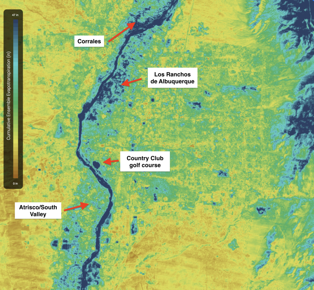
Albuquerque water use, via OpenET

I’ve been spending an inordinate amount of time the last few weeks pointing and clicking on the new OpenET project’s “data explorer”.

Using satellite data and magical algorithms, OpenET allows me to look at an arbitrary bit of land and retrieve an estimate of the amount of “evapotranspiration” – essentially outdoor water use – for recent years.

How green is Albuquerque’s Country Club golf course? How does the water use in the relatively affluent valley floor communities of Los Ranchos de Albuquerque and Corrales compare to the less affluent Atrisco and points to the south in what we call the “South Valley”?

Data wise, we have a pretty good handle on how much water Albuquerque’s largest municipal provider, the Albuquerque Bernalillo County Water Utility Authority, is delivering to customers each year, and how much of that water is returned to the river from the southside sewage treatment plant. But sometimes when I look at their data, I feel like I’m trapped in the old joke where I’m drunk and looking for my keys under a streetlight. (“Is that where you lost them?” someone asks me. “No, but it’s the only place where there’s any light!”)

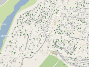
Domestic wells (green dots) in Los Ranchos de Albuquerque

Consider, by way of example, a patch of Los Ranchos I’ve been looking at for a while as I try to make sense of Albuquerque water use. I’ve been drawn to Los Ranchos because its one of the greenest places in our desert city. In addition to municipal water for indoor use, which is metered, many of the homes have access to irrigation ditch water (and a tax break if they put that water to agricultural use). Irrigation delivery here is not metered. Many of the homes also have domestic wells drilled into the shallow aquifer, which are also generally not metered.

So, in summary – super green there, looks like people are using a lot of water. How much? We don’t know, it’s beyond my streetlight!

Enter OpenET, which allows one to highlight a polygon on a map and spit out consumptive water use, by month, back to 2016.

My little OpenET Los Ranchos test plot is about 450 acres between Rio Grande boulevard and the river, stretching between Montaño Road and the northern edge of a leafy be-lawned neighborhood called Tinnin Farms. This area of Los Ranchos is one of the more affluent areas in the greater Albuquerque metro area. By my rough “danger Fleck doing OpenET math” calculation, consumptive use of water added to landscapes in this area (above and beyond precipitation) amounted to about 1,300 acre feet of water last year.

Who gets to use what water?

In one of the papers I’m always pushing on my students, the late Elinor Ostrom highlights a set of key characteristics – “design principles”, she calls them – of successful common pool resource management regimes. Ostrom is importantly not arguing for any particular best solution to these problems. (The paper’s title is “Why Do We Need to Protect Institutional Diversity“.) But in her lifetime of work, the Nobel laureate identified key stuff that tends to show up in places where people have succeeded at the challenge of sharing a limited resource to maximize its benefits to a community.

Ostrom’s design principles ask a bunch of useful questions, and I’d like to paraphrase as they apply to my little toy example: who will be allowed to use what amounts of water, and when? How will rules over this use be monitored and enforced, and how will conflicts be resolved?

I would argue that in my little Albuquerque Rio Grande valley floor neighborhood, we lack a full set of these tools. We have one set of rules for irrigation water, a second set of rules for municipal water, and a third set of rules for domestic wells. For most of this, we lack enforcement mechanisms or fail to use those that the law might allow. The three management rulesets do interconnect in technical legal ways that might allow them to be integrated into a single management approach. Also, unicorns would be so cool!

In my book Water is For Fighting Over (not), I spent a good deal of time on what I think is one of Ostrom’s most important points – the need for a shared understanding of what the resource is and how it is being used. In her thesis work, she tackled the development of shared water management institutions in a place prosaically called “West Basin” west of downtown Los Angeles:

To solve a common pool resource problem, you first need a shared understanding of what the resource is. This sounds simple, but in the case of the West Basin, it was not.

This is one of the most important pieces of my Colorado River work – why my favorite basin peeps all seem to have these amazing collections of spreadsheets on their hard drives that they use to help sort out questions. But that’s one of those “drunk looking for keys under the streetlight” things. One of the reasons I love working on Colorado River issues so much more than the Rio Grande is because there’s so much more light!

This is why I’m so excited about OpenET. If it works – which means both that it has to be technically solid and also earn our trust – it can shed some of the light I think we need.


New Mexico state engineer John D’Antonio stepping down, cites lack of state support for agency

Per Dan McKay and Theresa Davis at the Albuquerque Journal, New Mexico State Engineer John D’Antonio is stepping down.

In doing so, he was sharply critical of New Mexico Gov. Michelle Lujan Grisham’s decision to not ask the New Mexico legislature for increased funding for his depleted department despite booming state revenue:

[H]e cited a persistent lack of financial resources for the Office of the State Engineer and unfunded mandates as factors in his resignation. He expects several senior staff members who are eligible for retirement to announce departures, too.

“We’ve taken the agency as far as we can, given the current agency staffing level and funding resources,” D’Antonio said.

The agency, he said, has the equivalent of 67 fewer employees now than it did under then-Gov. Bill Richardson a decade ago, when D’Antonio served an earlier stint as State Engineer. But his office was still directed to submit a flat budget this year, he said, amid strong growth in projected state revenue.


Watch Live: Tipping Point – The Colorado River Basin

I’m heading to Phoenix tomorrow (Wed. Nov. 10) to appear on what I hope will be a useful PBS Newshour live event:

The Colorado River runs nearly fifteen hundred miles, winding through seven states and Mexico. It supplies drinking water to nearly 40 million people, irrigates nearly 4 million acres of farmland and attracts millions of nature lovers to scenic Grand Canyon vistas.

And it is on the brink.

A 20 year mega-drought — exacerbated by climate change — is squeezing the Colorado dry. It’s a crisis for the people of the Southwest and a “canary in the coal mine” for us all.

Join PBS NewsHour’s Miles O’Brien for a special hour-long live event exploring the relationship between climate change and the fate of the Colorado River Basin.

Hosted live from Phoenix, the program will foster a solutions-based dialog with leaders in areas of science, agriculture, municipal water, Native American communities and conservation.

Scaling back, even more, in the Lower Colorado River Basin

With the ink barely dry on the ill-named Colorado River “Drought Contingency Plan”, the Lower Basin states (Nevada, Arizona, and California) are already cooking up a Plan C for even deeper reductions. Joanna Allhands at the Arizona Republic has a nice look at what we know about the details:

Arizona, California and Nevada are moving forward with a plan to save another 500,000 acre-feet of water in Lake Mead annually until 2026.

We’re talking 500,000 acre-feet over and above the mandatory cuts that are spelled out in the 2019 Drought Contingency Plan (DCP). Each year. For five years.

Just to keep the lake from tanking.

Allhands does a nice job of going past the sketchy details made public in a webinar last week, but the sketchiness of the details is in part the deal itself, rather than what we know about the detail. We’re repairing the locomotive here in real time while it’s moving down the track.

Expect the federal government to kick some money to fund the water use reductions, along with the Southern Nevada Water Authority, the state of Arizona, the Central Arizona Project, and the Metropolitan Water District of Southern California. Importantly, you can expect MWD – California – to kick in water. Details are still being worked out, but the participants were confidence enough to go public with what they’ve got.

We’ll learn more as the various agency boards begin taking up their parts of the deal in coming weeks.

I’m curious when we might see some sort of similar initiative on the part of the states of the Upper Colorado River Basin.