Climate change and the water policy funnel

Climate change, as I’ve often heard Brad Udall point out, is water change. By that, Brad means that the effect of a changing climate on people and ecosystems is most clearly felt through changes in how much water there is.

I’ve been thinking about this question a lot as I work on three related projects – one in class with UNM Water Resources Program students, and two collaborations on papers with students and colleagues – that look at the implications of declining river flows on the Lower Colorado River.

In trying to model the impact of climate change on a particular piece of the environment (perhaps the Colorado River Delta or the Salton Sea) or some human community (Las Vegas, for example, or agriculture in the Imperial Valley) we want to model the impact of a reduction in available supply of water. So we model the baseline – how much water we have now – versus some sort of climate change projection of reduced flow. Brad’s “Twentyfirst Century hot drought” paper, with Jonathan Overpeck, offers some numbers. We should expect a 20 to 30 percent reduction in flow by mid century, they found, maybe 35 – 55 percent by the end of the 21st century.

I’m not saying these are the right numbers, but they’re reasonable and citable numbers that we can plug into the models my colleagues are developing to say “What if?”

It’s not wrong to do it that way, but it avoids by simplification one of the central climate change impact questions, because in reality the impact of climate change’s “water change” won’t play out that way. Reduced flow in the Colorado River is funneled through a bunch of upstream dams and diversions, which are managed according to a set of rules.

Those rules in effect act as a funnel through which the impact of climate change flows. If climate change reduces the flow in the Colorado River by 20 percent, does everyone share in those reduction equally? Do some users see a 40 percent reduction, while others see a 10 percent reduction? Do the farmers in Imperial have a senior right, meaning they won’t lose any water? Does the environment take an even bigger hit, or do we decide the environment has suffered enough and impose bigger cuts on farms and cities?

Partly this is in part about contested interpretations of existing rules, and in part about negotiating new rules. This is where the interesting climate change questions lie for me right now – in the water policy funnel.

On a bike, fighting through the pandemic fog, with Silver Surfer’s help

Fall colors, Rio Grande, Albuquerque, New Mexico, October 2020

I barely have anything to say, so I ride my bike.

Last Thursday, I rode through my 5,000th mile of 2020, something I’ve never done before. Like much of 2020, there will need be an asterisk next to this accomplishment, but it felt good to take the morning off and ride. Cycling has become my refuge – masked, helmeted, clad in my construction worker reflective vest, with my crazy flashing lights and computer data collection systems. In the fog of the pandemic – I don’t have the disease itself, just the grey cloud of life that surrounds it – I have been largely unable to write beyond the most perfunctory of work. I “don’t have the brain share”, is my shorthand. To ride creates an inexorable structure for the mind to follow.

“And I shall be true to my trust, for as long as I live.”

So in the days leading up to Thursday’s ride I carefully mapped a route, picked up the necessary miles ahead of time, so I could pass my 5,000th mile on Albuquerque’s Central Avenue Bridge over the Rio Grande, my favorite of favorite spots. I came close, mile 4,999.9 at my river overlook, so far within the margin of error of the data as to be indistinguishable from my arbitrary arithmetic goal.

The route included my favorite bits of the city – both secret tunnels beneath the railroad tracks (one going, one coming), the stretch of gravel levee along the river’s west side, long stretches of old Route 66, the “Bandidos’ park” for one of Albuquerque’s great city views.

On the way home, I paid a visit that’s become a ritual nearly every ride since early summer – a visit to the Silver Surfer. The creation of @irotism and @release1201, Silver Surfer showed up in late June or early July, filling plywood space left by the boarding of downtown Albuquerque windows.

In our time of need, Silver Surfer has become a ritual comfort. I don’t really know Silver Surfer beyond the downtown paintings and a bit of reading on Wikipedia, but I imagine something helpful every time I visit.

My miles haven’t lifted the fog, but rather have created a safe space within it.

What do we mean at the UNM Water Resources Program by “interdisciplinary”

One of the ongoing struggles for me as an academic outsider working in a university is mastering the language. In the course of a recent discussion of the term “interdisciplinary” (the UNM Water Resources Program is “interdisciplinary”) I ran across this language I put in a program report I wrote last year in which I attempted to understand disentangle the terminology:

Interdisciplinarity

The program is, by construct, “interdisciplinary,” interpreted broadly. There are a number of different definitions and labels for this concept:

  • “Multidisciplinary” – researchers from more than one discipline bringing their separate disciplinary perspectives to a problem, each retaining their own disciplinary focus,
  • “Interdisciplinary” – the use of an innovative blend of more than one disciplinary focus, creating a synthetic approach to a problem,
  • “Transdisciplinary” – the incorporation of non-academics along with academics in a research effort, bringing a more practical problem-based focused to the integration across disciplines.

While the University of New Mexico Water Resources program embraces the label of “interdisciplinarity,” and does work that most closely matches “transdisciplinary” as defined above, it is agnostic about the details of the labeling, comfortably doing work that matches many different flavors of work across disciplines, in and out of the academy.

This remains for me a helpful framework for thinking about what we do. The bit above even had a footnote!

The question of reservoir evaporation – How much water are the Lower Colorado River Basin states really using?

Accounting for Lower Colorado River Basin water use, with and without evaporation

The conventional simplification of the Colorado River Compact’s water allocation scheme is that it set aside 7.5 million acre feet of water use for the “exclusive beneficial consumptive use” of the states of the Lower Basin – Nevada, Arizona, and California.

In the 21st century, the official accounting shows the Lower Basin states using an average of 7.4 million acre feet per year (the blue line in the graph above), so we’re good, right?

Well, actually….

When the states of the Upper Basin gathered in the late 1940s to negotiate the Upper Basin Compact, they recognized that if you’re going to build a reservoir to enable the consumptive use of water, you need to account for the evaporative losses from that reservoir.  Article V of the Upper Basin Compact goes into some detail about how to account for “all losses of water occurring from or as the result of the storage of water in reservoirs” built by the states and the federal government.

But, as Eric Kuhn reminded us in a post yesterday, we don’t have a corresponding Lower Basin Compact. Instead, we have the 1963 Supreme Court decision in Arizona v. California, and the subsequent implementing decrees, to set the parameters for the water’s allocation. The court didn’t require an accounting of evaporation, only the water actually released from the reservoir.  Here’s Eric:

I have no doubt that the 1922 compact negotiators considered this evaporation a man-made beneficial consumptive use to be covered by the (water) apportioned to the Lower Basin, but it is not covered in the Supreme Court’s decision.

Not everyone agrees about the compact negotiators’ intent. See for example Jason Robison and Larry MacDonnell in their review of AZ v. CA. But Robison and MacDonnell also note that the subsequent failure to fully wrestle with the question of reservoir evaporation and related questions like Lower Basin tributary use – the sort of things that negotiating a Lower Basin Compact might have adressed – has left a bit of a mess.

Legal nuances aside, the reality is that in the absence of a Lower Basin Compact to come to a negotiated agreement on questions like this, we’re left with significant uncertainties on this and other questions. And by my math, if you count reservoir evaporation, the Lower Basin states have been using an average of 8.4 million acre feet a year in the 21st century (the pinky-orangey line above). On this point Kuhn, Robison, and MacDonnell agree – that’s a problem.

The Lake Powell Pipeline and the problems posed by the lack of a Lower Colorado River Basin Compact

By Eric Kuhn

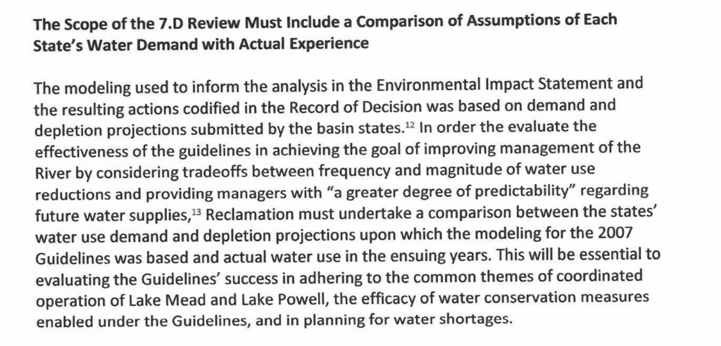
The Lake Powell Pipeline, moving Upper Colorado River Basin water to the Lower Basin

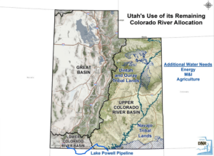
As the Colorado River Basin’s managers wrestle with thorny questions around the proposed Lake Powell Pipeline, a colleague who works for a Lower Colorado River Basin water agency recently asked a question that goes to the heart of the future of river management: With land in the Lower Colorado River Basin, why doesn’t Utah have a Lower Basin allocation?

The answer, arising from deep in the history of the Law of the River, goes far beyond the possible use of some of Utah’s Upper Basin water in the Lower Colorado River Basin’s Virgin River Valley. It strikes at the heart of important and as yet unresolved questions in the river’s future – about accounting for reservoir evaporation, and who bears the responsibility for, and benefits from, water flowing down the Lower Basin’s tributaries.

The lack of a “Lower Basin Compact”

The simple answer to my colleague’s question is that Utah has no apportionment of Lower Basin water because there is no Lower Colorado River Basin Compact.

The negotiators of the 1922 Colorado River Compact allocated water to the Upper and Lower Colorado River Basins with the clear intention that the states of each basin would return to the negotiating table to work out the details of how their share of the water would be allocated and accounted for. The states with Upper Basin interests completed the task in 1948, negotiating the Upper Colorado River Basin Compact. Notably Arizona, which is not an “Upper Division State”, but which has land in the Upper Basin, participated, and was allocated a share of the Upper Basin’s apportionment.

In the 1920s and ’30s, there were many attempts, all unsuccessful, to negotiate a Lower Basin compact.  They came close in 1927 when the basin governors met in Denver for the specific purpose of resolving the differences between Arizona and California.  The Senate used the deliberations from 1927 as input to the mainstem apportionments to Arizona, California, and Nevada provided for in the 1928 Boulder Canyon Project Act. But the language of the Act clearly suggests Congress expected a Lower Basin Compact to be negotiated to flesh out the details, much as later happened in the Upper Basin.

That never happened, though, and in the absence of a Compact, the present-day apportionments we all know so well – 4.4 million acre feet for California, 2.8maf for Arizona, and 300,000 acre feet for Nevada – are based on the Supreme Court’s interpretation of the intent of Congress when it debated and passed the Boulder Canyon Project Act in 1928. But in the absence of the a careful process of negotiation to cover the full range of issues that needed to be considered (as happened in the Upper Basin), the Supreme Court’s decision was narrow. It only covered under contracts between the federal government and water users downstream of Hoover Dam – not for water consumed on the Lower Basin tributaries or on the Lower Basin’s portion of the mainstem above Lake Mead.

In the 1930s, William Donovan came close

In 1930 President Hoover appointed Colonel William Donovan as special mediator to negotiate a Lower Basin compact.  Donovan came close, but Arizona and California just could not make one final compromise. In both the 1927 and 1930 near misses Utah and New Mexico would have received from the 8.5 million acre-feet apportioned by the 1922 compact to the Lower Basin “all water necessary for use on areas of those States lying within the lower basin” – (see Science Be Dammed, chapter 8).

In 1952 when Arizona filed its Supreme Court case against California, one of its initial goals was a Court ruling that would be functionally equivalent to a Lower Basin compact. Among its claims for relief was that the court find that Arizona had the right to use all the one million acre-feet apportioned to the Lower Basin under Article III(b) subject only to the “rights of New Mexico on the Gila River and Utah on the Virgin River.”  As the case proceeded, Arizona changed its tactics.  It amended its original claims for relief arguing that the case was no longer about the compact.  Instead, it was only about the intent of Congress to apportion water under the 1928 act.  The Special Master and Supreme Court agreed and ruled that the Colorado River Compact need not be interpreted to decide the case. Since the court’s decision was limited to the water used in and below Lake Mead and avoided the compact, it falls well short of a Lower Basin compact.

Would we be better off with a Lower Basin Compact?

The entire basin would be much better off with a functioning Lower Basin compact. The problem is that to get there, the five states with Lower Basin interests – Arizona, California, and Nevada (the “states of the Lower Division”), plus Utah and New Mexico, which also have watersheds falling within the Lower Basin’s boundaries – would have to negotiate through several difficult issues that have never been resolved and for the moment are conveniently tucked away.  These issues include dividing up the one million acre-feet of III(b) water, the “bonus water” provision added to the compact late in negotiations to sweeten the deal for Arizona. In addition to addressing the Lower Basin needs of Utah and New Mexico, Nevada also needs a piece of III(b) water to cover its uses on the Virgin and Muddy Rivers.  Water from the dry-up of previously irrigated lands in these two drainages supplies the Southern Nevada Water Authority.

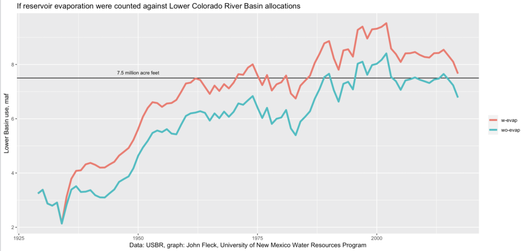
A second issue is dividing up the substantial evaporation use on the Lower Basin mainstem reservoirs.  I have no doubt that the 1922 compact negotiators considered this evaporation a man-made beneficial consumptive use to be covered by the 8.5 million acre-feet apportioned to the Lower Basin, but it is not covered in the Supreme Court’s decision.

Third, there are difficult Lower Basin accounting issues to resolve, including how compact apportionments are to be measured. Yes, a century after the compact was signed, this fundamental issue has never been resolved (see Science Be Dammed, chapter 12). Another unresolved accounting  question is how to address the depletion of groundwater hydrologically connected to the Colorado River.

These accounting issues point to a bigger issue. The primary purpose of a Lower Basin compact would be to allocate among five states 8.5 million acre-feet of beneficial consumptive use – the amount apportioned to the Lower Basin by the 1922 compact. How would a compact address the reality that when tributary uses, reservoir evaporation, and hydrologically connected groundwater are considered, the Lower Basin is currently using more than 8.5 million acre-feet?

These major unresolved issues are why in Science Be Dammed John Fleck and I conclude that there is little incentive and major downsides for important playsers to a Lower Basin compact, thus it is unlikely to happen. The problem from my perspective as a former manager of an Upper Basin water agency is that through the 1948 Upper Basin compact, reservoir evaporation, hydrologically connected groundwater, and overuse are all addressed. Without a Lower Basin compact, important elements of the equity between the basins are missing.

The Gage Selfie Collection: Rio Grande at Albuquerque

One of our recent University of New Mexico Water Resources Program graduates suggested an extra credit assignment for this year’s students: stream gage scavenger hunt, with selfies.

Here’s the measurement point for USGS 08330000, Rio Grande at Albuquerque, NM. Flow at the time I took it yesterday morning measured 111 cubic feet per second.

Am I eligible for the extra points?

Record low flows on New Mexico’s Rio Grande

Record low flows on the Rio Grande at Embudo

Flow on the Rio Grande at Embudo in north-central New Mexico as I write this is measured at 156 cubic feet per second, which is the lowest for this date in history. And its quite a history – Embudo was the first gage installed by the USGS, back in the winter of 1894-95.

Note that I’ve switched to log scale for the graphs, which better distinguish the really flows. Of which 2020 is one.

Happy New Water Year, where’d all that Colorado River water go?

End of Water Year 2020

Shrouded in pandemic fog, I’m only now getting to my sorta annual “Happy New Water Year!” post, where I traditionally look on in alarm at dropping Colorado River Basin reservoir levels and make fun of the Lower Basin for using too much water.

The alarm remains – after a crappy runoff, combined storage in the two big reservoirs behind Lake Powell and Lake Mead is down 1.7 million acre feet from a year ago. For the ~40 million people depending on the Colorado, this is cause for concern. But the water use trends continue to bend in a way that has taken some of the steam out of my old jokes about users wasting all their bonus water on “hookers and blow”.

Reviewing the ’07 Guidelines

The start of water year 2020-21 offers a good moment to look back beyond a single year and see how the basin’s been doing.

Doing trend line analysis is always a rigged game, because so much of what you see depends on the arbitrary starting point you use.

But with the Bureau of Reclamation in the midst of its review of the basin’s 2007 Interim Guidelines, we have a non-arbitrary starting point at which to look at trends. 2007 is when the basin first adopted what we might think of as “drought operation rules”, aimed at reducing the decline of the two big reservoirs.

So, since 2007, how has the basin done?

Shrinking supply

From the supply side, things look bad. The river’s flows since 2007 have been ~1.2 million acre feet below the long term averages fed into the model projections done in support of the development of the 2007 guidelines, an 8 percent reduction in flow. The climate change shark is, as Brian Richter noted recently, circling nearby.

But despite that reduction in flow, total storage behind Glen Canyon and Hoover dams, the two primary system reservoirs, has dropped only 2.6 million acre feet. That is far less than you’d expect from 12 years of 1.2 maf per year flow reductions alone.

That kind of a flow reduction should have been enough to nearly empty the reservoirs. Why hasn’t that happened?

Shrinking demand

Because we also have been using less water.

Municipal and agricultural use of Colorado River water since 2007 has averaged 1 million acre feet per year less than the projections used to underpin the analysis done in support of the 2007 interim guidelines. With growing water conservation efforts, 2020 water use is on track to be 1.5 million acre feet below the demand projections used in the 2007 guidelines’ analysis.

Across the Colorado River Basin, among both Upper Basin users and Lower Basin users, folks are using less than their legal entitlement under the Law of the River. This is not enforced conservation. This is folks realizing they’ve got less water, so they’re using less.

As regular readers of this blog know, I think a better understanding of this demand side change is crucial to mapping out our policy options for keeping the reservoirs from collapsing. Here is how a group of academics (myself, Anne Castle, Jack Schmidt, and Doug Kenney) put it in a May 1 letter in response to the Bureau’s request for comments on the scope of its current review of the Interim Guidelines (full letter here):

The bottom line

In fact the modeling done for the ’07 guidelines, when you look at the projections for reservoir levels for the last 12 years, looks pretty good. The levels of both Powell and Mead are well within the range of likely scenarios the Bureau modeled for the Interim Guidelines EIS – a bit below the median, but well above the “OMG SCARY” scenarios the Bureau considered as unlikely but plausible. Our misunderstandings of both supply and demand were, to first order, offsetting errors of roughly the same magnitude. But as we look back in preparation for looking ahead to the next round of negotiations, it’s important to to dig into the details of what we got right and wrong in that remarkable ’07 planning exercise, and why.

nota bene: A huge thanks to Jack Schmidt and Jian Wang at Utah State University for their analysis of Upper Basin demand projections, and especially to Jian for open-sourcing the underlying data.

The “Colorado River Simulation System” and Elinor Ostrom’s “authoritative image of the problem”

Ostrom 1990, Governing the Commons

Burnishing my notes for UNM Water Resources class this afternoon to talk about Elinor Ostrom, I spent a bit of my morning going back through the underlined bits in my copy of her seminal book Governing the Commons. I first read it in the fall of 2009, when she won the Swedish prize. My initial scratchings in the book – Wait, what? They imposed constraints on themselves? – are instructive.

My rereading of Ostrom comes as I’m in the midst of a little side project digging into the history of something called the “Colorado River Simulation System”, a computer model that is central to 21st century Colorado River management. CRSS, as it’s called, brings together the best hyrdologic understanding of how the basin operates with policy rules, serving as a sort of common language for talking about the river and making decisions about its future.

It is impossible to overstate the impact of the intellectual light bulb that fall when I first read Ostrom. I’d recently finished my first book and was eyeing taking a stab at writing something about the Colorado River. Lake Mead had been steadily dropping and, fully steeped in the “tragedy of the commons” narrative, I imagined that my task was to chronicle its collapse. The federal government did not seem up to the task of imposing a centralized authority on the system, and the “tragedy of the commons” conventional wisdom suggested water users would be unwilling to impose constraints on themselves?

Yet here was Ostrom, as characterized by the Nobel committee’s press release:

Elinor Ostrom has challenged the conventional wisdom that common property is poorly managed and should be either regulated by central authorities or privatized. Based on numerous studies of user-man-aged fish stocks, pastures, woods, lakes, and ground-water basins, Ostrom concludes that the outcomes are, more often than not, better than predicted by standard theories. She observes that resource users frequently develop sophisticated mechanisms for decision-making and rule enforcement to handle conflicts of interest, and she characterizes the rules that promote successful outcomes.

Crucially, Ostrom argued that such successful problem solving was not a given. But she offered an intellectual toolkit for understanding what to look for.

Central to that is what, in Governing the Commons, she described (in her case study of Southern California’s Raymond Basin) as “a single, authoritative ‘image’ of the problem.” This amounts to a common, data-based understanding of the system on which decisions can be based, scenarios played out.

In the years since, I have come to understand the way CRSS plays that role. A sophisticated model built on the Riverware platform, it is used by the Bureau of Reclamation, major water agencies across the basin, environmental groups, and university researchers to study the implications of drought, climate change, and water policy options as we navigate the Colorado River Basin’s future. It is, to borrow a phrase from one of the people I spoke with while working on my little dive into CRSS’s history, the common language we speak in the basin.

Want to know what the risk of Lake Powell dropping to levels at which Glen Canyon Dam can no longer generate electricity? The Colorado River District’s Risk Study used CRSS to do that. Want to know the risk of a continuation of the dry conditions of the 21st century continuing, or worsening? We have the “Stress Test” and the “Super Stress Test”, simulations written in the language of CRSS, a language that basin managers can understand, to help us. Want to evaluate climate change scenarios against paleo droughts? Homa Salehabadi and colleagues at Utah State have done that, offering their answers in CRSS, a language decision makers can understand.

It is not without its limitations. It constrains the questions you can ask, and I watch people struggle now to bend it to the task of sorting out things like environmental flows through the Grand Canyon, or better understanding the Upper Colorado River Basin’s consumptive uses, past and future. Some of the constraints are technical. Some are political. But for the basic task of helping the basin’s water management community understand its choices, providing an “authoritative image”, it continues to perform admirably.


Ghost of Water: The Inauspicious end of the Alameda Lateral

Alameda Lateral, Albuquerque, New Mexico, 2020, by John Fleck

I’ve driven by the spot in the picture a jillion times in the 30 years I’ve lived in Albuquerque, and never noticed the ditch squeezed between #1 Plumbing and Air and the Chevron station on the corner of Edith and Candelaria.

My latest pandemic bike riding project involves scouring GIS data from the Middle Rio Grande Conservancy District, the irrigation district in our part of the Rio Grande Valley, in search of abandoned ditches. The last few weekends my friend Scot and I have been piecing together the remnants of the Barelas Ditch south of downtown. This weekend we turned our attention to the Alameda Lateral, which used to irrigate the east side of what we call Albuquerque’s “North Valley”.

The air was smoky today, so it was a perfect day for the sort of lazy stop-and-go riding needed to find traces of old ditches – folded up paper maps with scribbles in my pocket along with my oatmeal cookies.

MRGCD Alameda Wasteway control structure

At the spot where I took the picture, the Alameda is just a wasteway, no irrigation water because no irrigated land “downstream” of the trash rack in the picture. A block or so downstream, it’s completely underground, but there’s an incongruous irrigation system control structure flanked by busy street, apartment complex, and construction company equipment lot. You can’t just plug an irrigation canal, you have to have a way to let the water drain out the bottom end. So whenever the Alameda downstream from here was formally abandoned, they buried a wasteway conduit to carry what was left over to the big open air “Alameda Interior Drain”, one of the most visible water features in this part of the North Valley.

Scot and I spent a bunch of time trying to find the upstream bits of the canal (our Strava GPS from the ride is hilariously squiggly), riding up and down the neighborhood streets. A lot of it is underground, passing beneath the light industrial stuff that long ago displaced the marginal agriculture that used to scratch by in this valley.

My GIS skills aren’t great, but here’s my attempt at showing this segment of the ditch: