The Politics of the Colorado River Compact

In a debate between candidates for Colorado Congressional District 3 (the western part of the state, including the west slope and Colorado river), the two candidates are reported to have shown clear agreement on an important point:

Both pledged heartily to fight all efforts to reopen the Colorado River Compact.

Also, all efforts to switch the United States to a monarchy with Lada Gaga as queen will similarly be opposed with the utmost utmostness.

La Niña and the Colorado

Colorado River Basin

Colorado River Basin, Courtesy Scripps Inst. of Oceanography

With La Niña rapidly strengthening, it is reasonable to ask what can be said about the resulting effect on flows in the Colorado River. The short answer: not much.

It is reasonable to guess otherwise, because so much of the southwest depends on the Colorado for its water supply, and because La Niña is so well known as a bringer of drought in the southwest. But the important fact here is that La Niña’s strongest effect is found in the southern part of the basin, while most of the Colorado River’s water comes from the northern part of the basin.

You can see from the map above that the Colorado River Basin stretches across mountainous western Colorado and into Wyoming. The vast majority of the Colorado’s flow falls in the area colored green on the map, which very little contribution from the desert rivers of the lower basin (the brown bits). For all practical purposes, the flow measured at Lee’s Ferry defines the available water on the Colorado system, which is why that was the point chosen for dividing the river’s water under the Colorado River Compact.

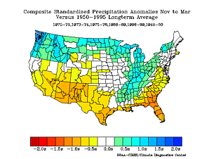
Precipitation Anomalies

Precipitation Anomalies, courtesy ESRL

As you can see from map number two, La Niña’s effect on precipitation is far greater to the south, and less to the north. This is Nov-March precip, which is the snowpack season and captures the key climatological period in terms of both water supply development and also La Niña’s effect. The color scheme represents standardized precipitation anomalies in standard deviations from the mean during La Niña years. The main message is that yellow is a little drier than average, browns are a lot drier, and Florida and southern Georgia are screwed. But that’s the subject of another blog post.

But we’re really interested here in water in the river, not rain and snow falling on the ground. The folks at the Colorado Basin River Forecast Center have an excellent, user-friendly collection of data. I look at their estimates of naturalized Lee’s Ferry flow (what it would have been if not for upstream dams and diversions). What it shows is that there is almost zero correlation whatsoever between the El Niñ0-La Niña condition (ENSO) and flow on the Colorado River. Here, for example, is April – July streamflow (the months when the vast majority of the water is coming off) compared to sea surface temperature in the ENSO 3.4 region, which is the key area for impacting our climate, from Nov-March. You can slice up the data a lot of different ways, but there’s just not much of an effect on average at Lee’s Ferry:

ENSO and Colorado River Flow

ENSO and Colorado River Flow, courtesy CBRFC

(A big thanks to Kevin Werner at the CBRFC for helpful discussion today about this issue.)

Hoover Dam, Servant of the People

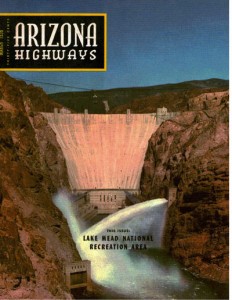
Lissa found a treasure for me at Sam Weller’s in Salt Lake City – the March 1956 issue of Arizona Highways:

Arizona Highways, Lake Mead, March 1956

Arizona Highways, Lake Mead, March 1956

Among the gems within is Ak Akvik’s Servant of the People (tribute to Hoover Dam). An excerpt:

Below,
stilled forever
the red rage of the angry river.

Below,
in blue serenity,
as docile as a week-old lamb,
the fever and boiling fury of the flood.

I helped win a war.
I bring light to a million homes.
I turn countless wheels in numberless factories.
Because of me, hundreds of thousands of acres
of useless land now grow green and nourishing crops.

I’m a shining and triumphant chapter in the epic of America.
I’m a servant of the people.

By a useful coincidence, the spring of 1956, during the heart of the drought of the 1950s, was the month at which Lake Mead hit what remains its historic low since it was filled in the ’30s. There’s no mention that I can find of drought in the Arizona Highways paeans to Mead’s recreational beneficence. But in some of the pictures of happy water skiers and fisherpeople, you can see a bathtub ring in the background.

The lake surface level ended the month of March 1956 at 1083.57 feet above sea level (historic monthly data here), which I’ve been calling the historic low. But the fine folks at the USBR in Boulder City recently fed my obsession with this historic milestone by pointing me to some more fine grained data, based on daily and in some cases hourly readings. The numbers show that Mead dropped further, down to 1083.19 by April 26, 1956, before beginning to rise again with the spring snowmelt.

As I write this (midday, Sept. 18, 2010), the lake level is at 1085.42, a bit over 2 feet above the historic low. The latest forecast numbers show Mead dropping past its April 1956 low some time during the third week of October.


Water Wars, Southeastern Style

Speaking at a symposium in Las Vegas in April, former Bureau of Reclamation Commissioner Bob Johnson made a critical point about the differences between water problems on the Colorado River and the current struggles in the southeast over the Apalachicola-Chattahoochee-Flint and Alabama-Coosa-Tallapoosa river basins.

Lake Lanier

Lake Lanier

The ACT-ACF fights made the Economist this week, in an article that plays on the amusement we westerners enjoy on watching this wet country water war:

For Americans from the parched western states, the notion of Alabama, Georgia and Florida battling over water must seem as daft as three fat people fighting for a grape at a lavish banquet.

Being a former head of Reclamation, Johnson knows Colorado River issues well, and in his talk he compared them to the interstate legal water wars now underway among Georgia, Alabama and Florida over water from the two river basins (battles in which had played a role as part of federal efforts to mediate).

The ACT and ACF basins have far more unallocated water to play with in sorting out the conflicts. “They’ve got 60 million acre feet of excess water,” he said. “On the Colorado River, we’ve got zero.”

But as a direct result of that lack of water on the Colorado, we’ve got a rich legal framework – the Law of the River – and accompanying personal and institutional relationships to go with it. “We have 80 years of fighting and working together,” Johnson said to the audience of Colorado River Basin water officials.

By comparison, in the wet climate of the southeast, water officials had few relationships with their colleagues in other states, and few institutional structures through which they could deal with problems when they arose, Johnson argued. In other words, they have plenty of water, but lack the tools they need to approach the problem of sharing. Because they’ve never had to think of it that way.

I’ve written in the past about how relatively modest, in historic terms, the Atlanta drought was. Modest drought, disastrous consequences. By comparison, we’re the 11th year of a drought on the Colorado River that is anything but modest – the worst such stretch on record. Yet, as I’ve written, no one has had their water cut off. In other words, our institutions seem to have worked.

Arizona’s Water Troubles

I am the type of journalist who loves a juicy, seemingly intractable political/policy problem. That’s why I love writing about water. But as a New Mexico water writer, I confess to a certain amount of envy at my colleagues to the west. Sure, we’ve got some tough water problems in our state. But they are limited, I think, by our relative poverty. We haven’t come as close to testing the boundaries of available supplies as folks in Arizona and California.

That’s a circuitous way of getting to Shaun McKinnon’s post yesterday afternoon on the state of Arizona’s efforts to reconcile the state’s growth curves with its dwindling water supplies:

In the back pages of a new report about Prescott’s future water supplies, the Arizona Department of Water Resources warns, in unmistakably clear terms, that, under the agency’s current authorities, the state will fail to meet its sustainable water resource goals without changes in the way water is managed.

The conclusions are significant and should be required reading for policy makers at every level of government, from city councils on up to the Legislature. One phrase in particular is important: The current structure will not only result in unmet goals, it “may over time move us farther away.”

What I’d really love would be the chance to write about the Sacramento-San Joaquin Delta. Now there’s a sweet story. Maybe I should start a blog about water or something. 🙂

Stuff I Wrote Elsewhere: The FOIA’s in the Mail

From the newspaper this morning a column (sub/ad req) on my frustration with the disconnect between the Obama administration’s soaring rhetoric about public information and transparency and the gritty reality faced by those in the trenches trying to get public information:

With the arrogance of a federal agency that has become accustomed to a lack of accountability for its breathtaking history of delays and cost overruns on big nuclear projects, the National Nuclear Security Administration refuses to release key documents that might answer these questions.

It is hard to know whether the agency is trying to cover up some serious problems that would be revealed by the documents, or whether it is simply a bureaucratic instinct (common at the agency) to circle the wagons to avoid embarrassment over its woeful nuclear project management record. Whichever it is, it clearly does not reflect the sweeping language of one of Barack Obama’s first executive orders when he took office in 2009: “A democracy requires accountability, and accountability requires transparency.”

River Beat: The Flood of 1905

I love this picture of what I can only assume are three rascals defying their mothers and swimming in the New River, in the Imperial Valley of Southern California in 1905.

New River, Imperial Valley, 1905

New River, Imperial Valley, 1905, Courtesy USGS

The New River, in the incarnation seen here, was formed when the Colorado River ate through a poorly built intake structure and chewed up the canals that were supposed to be carrying water to make what had been called the Colorado Desert, ambitiously renamed Imperial Valley, bloom with agricultural riches. The flooding was no doubt a disaster for these teenagers’ families, but they seem to be enjoying themselves.

Who Should Pay to Clean Up Our Messes?

On the Public Record, the California water blogger, is his/her usual pithy self in response to a truly awful Sacramento Bee editorial about the cost of cleaning up its sewage. The problem is ammonia in Sacramento’s sewage, which causes havoc downstream. The Bee’s argument (really, I am not making this up) is that if people downstream want the pee cleaned out of their water, they’ll have to pay:

If beneficiaries of a possible peripheral canal want cleaner water for their big straw, they should be prepared to pay for it.

OTPR’s response:

If downstream people want to use our effluent, they can pay for (some of) cleaning it? Look, I know tail-enders get the shaft, but that’s an artifact of the physical world, not an admirable policy that we say out loud. What happened to “Leave No Trace” and “Clean up after yourselves.”?

My Education in Economics

On my regular drive home, there’s a Red Roof Inn (and Suites!) by the freeway with a big sign advertising its price. It’s typically $49.99 (often $59.99 weekends) for a room. But during our annual Balloon Fiesta in October, when the town fills up with tourists, the price typically goes up to $89.99 or $99.99.

“Price gouging,” I used to mutter as I drove by.

Then I took some classes in economics and read a bunch.

Now during Balloon Fiesta, when the price goes up, I say to myself, “That makes sense.”

Stuff I Wrote Elsewhere: Diversions, Consumptive Use and those Pesky Return flows

Out here in the inland arid western United States, water management is complicated by the convoluted question of what happens to the water after we “use” it.

Sometimes it’s used up. Sometimes we put it back, in a way that allows others to use it.

Largest Tributary on the Middle Rio Grande

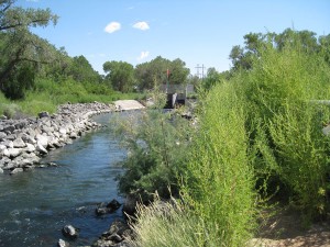
Largest Tributary on the Middle Rio Grande

Regular Inkstain readers, all three of you, will recognize this theme from a riff a few weeks back on my visit to Albuquerque’s sewage treatment plant. With some thematic tweaks, I turned it into a newspaper column (sub/ad req):

A groundbreaking last week at the sewage treatment plant illustrates the issue. Dignitaries did the traditional shovel-in-dirt ritual to ceremonially launch construction of a treatment plant that will add an extra level of cleaning to about 5 percent of the wastewater now going into the Rio Grande. Instead of sending it to the river, it will be pumped into a newly built network of pipes to irrigate parks on Albuquerque’s south side.

In other words, instead of returning it to the system, it will be consumptively used. We’ll be able to reduce our groundwater pumping or river diversions by a like amount, but it’s not like we’re getting free water here. In terms of the overall amount of water in the system, the net effect is essentially zero.