The dance of a city and its river

Moonset over the Rio Grande, Albuquerque, New Mexico, Feb. 16, 2022

I woke up super early yesterday, couldn’t get back to sleep. To calm my spinning brain, I layered on some warm clothes and my dayglo construction worker safety vest, grabbed the bike lights off of their charger, and went for a ride.

The moon was full, or close to it, sinking into the western sky as I rode toward the Rio Grande. I can still remember the morning some years ago when I realized I could get to the river on an hour-long morning ride – half hour down, half hour back, plus whatever bonus wandering happens along the way – and I’ve done it hundreds of times since.

It never gets old, engaging my mind in a sort of mindful flow that slips me away from everything else – through downtown, past Albuquerque’s Old Town, and out to the river.

Yesterday’s ride was special (aren’t they all?). My demons were unusually large, and the ride rose to the occasion, offering me a pre-dawn chase of a setting full moon, a gift up to the task.

Over Albuquerque’s icononic pointy building, then the Old Town cathedral, the moon.

But at the river. Oh my.

The new book I’m working on with Bob Berrens is an ambitious effort (for me it feels ambitious, it’s stretching my storytelling muscles) to understand and then explain the complex back-and-forth between Albuquerque’s Rio Grande and the human communities around it.

Place has always been central to my writing, and for me Albuquerque’s Central Avenue Bridge is a mental geographic anchor. It is where Route 66 was shifted in 1937 to become Albuquerque’s primary highway gateway from the west. (Our drafts are sprinkled with comment tags – doublecheck the date!) Look down from the east end of the modern bridge when the river is low and you can see pilings from one of its ancestors.

Bridge and river are inseparable pieces of the same story. Who built it and why? How did its construction change the river flowing beneath it? And bridges are the least of it – the levees flanking the river, the drains beyond, swamp turned golf course and neighborhood and city park.

In their dance, the river and highway both bend there in a way that the view upstream yesterday left a trail of reflected moonlight. I hopped back on the bike and trailed south, to a viewing platform built some years back that is a favorite, special family river spot. We call it “the posole platform” after graffiti scrawled on a railing.

They city recently strung lights across the bridge, and their light joined the moonlight, dancing across the river.

As an old reporter friend liked to say, you can’t make up shit that good.

A lack of curiosity about the Colorado River’s flow: 100 years ago in Compact negotiations

By Eric Kuhn and John Fleck

Col. James Scrugham, Nevada’s representative to the Colorado River Compact negotiations

As the Colorado River Compact’s negotiators got down to work a century ago, their lack of curiosity about how much water the river might be able to provide began to emerge.

Colorado’s Delph Carpenter understood that he represented the interests of a headwaters state. Four major rivers, including the Colorado, originated in the high mountains and table mesas of his state. All its rivers flowed out. Colorado had all the physical water it needed; Carpenter needed to avoid legal claims by downstream states before future Coloradoans could use their share of the water. From Carpenter’s perspective there was a much simpler approach to protecting Colorado’s interests than apportioning water among seven sovereign states based on irrigable acres, as was being initially discussed.

Q: How much water do we need? A: A lot.

After taking Sunday off, the Colorado River Commission met twice on Monday, January 30th. In the morning session, the water requirements committee reported back to the Commission. The fundamental flaw with the Hoover/Davis apportionment concept surfaced almost immediately. The committee presented two different sets of estimated irrigable acres for each state, one made by the Reclamation Service and the other made by the states. The states’ estimated total was much larger, especially in the upper river states. With optimistic hydrology and using the Reclamation Service acreage data there might have been enough water to meet the needs of the seven states and Mexico (at this point in the negotiations, although Mexico was not invited to the meetings, its water needs were being considered as if it were a state), using the states acreage data, there was nowhere near enough water.  While there were only minor differences on the data for existing acres under irrigation, the Reclamation Service estimate of potentially new irrigable acres in the four upper river states was 2,500,000 acres. The states’ estimate was 4,805,000 acres, almost twice as much. Although the differences were much smaller, there were problems with the lower river data as well. The Reclamation Service had no new data for Nevada, a state that would never have much irrigation and subsequently end up with a very small piece of the river.

Despite the problems, five of the seven state commissioners, including New Mexico’s Steven Davis and Wyoming’s Frank Emerson, tried to find a way forward to a compact based on irrigable acreage. Delph Carpenter and R.E. Caldwell of Utah would not budge. Hoover even asked Steven Davis to meet with Carpenter to break the impasse. He failed; Carpenter had a fundamentally different approach in mind.

But how much water does the river actually have?

Lost in the debate over future water requirements was the report of the water availability committee. There is little discussion of the committee’s report in the minutes of the 6th meeting. There is a simple statement that the amount of water is assumed to be 17.3 million acre-feet annually, the numeric average of the Yuma gage from 1903 -1920 uncorrected for the reality that in 1903 there was far less upstream development than there was in 1920. This lack of curiosity over the water supply data would be a consistent theme for the remainder of the negotiations.

Carpenter’s initial gambit, and Scrugham’s compromise

At the 7th and final commission meeting in Washington, D.C. Carpenter presented his proposal for a compact. Carpenter proposed that the lower river states allow the upper river states to consume water without any interference whatsoever from the lower river states (note; this was before the basin was split into Upper and Lower Basins and these terms were used). His suggested language “the construction of any and all reservoirs and other works upon the lower river shall in no matter arrest or interfere with the subsequent development … of the upper states.” Carpenter’s logic was that because of the climate and topography in the upper river, water use above the great canyons in Northern Arizona presented little or no risk to the lower river. Irrigators in the high country had a short growing season and most water diverted to their fields would end up back in the river as return flows. The lower river commissioners countered that without some reasonable limitation on uses on the upper river, they would be unable to finance their projects. In a constructive role he would play throughout the negotiations, Nevada’s Colonel Scrugham suggested a compromise. He proposed that the lower river would not interfere with the upper river for a limited period, say 20 years. Carpenter rejected the compromise, unsure how long it would take for the upper river to develop additional water.

Although Carpenter’s proposal was rejected by the lower river commissioners, his logic was prescient.  During the debate over his compact proposal, Carpenter quickly realized that he’d fumbled the issue of out-of-basin exports. Recognizing that his logic didn’t work for exports which were 100% consumptive, Carpenter signaled that he would accept a reasonable limit on exports.  In Silver Fox of the Rockies, historian Daniel Tyler suggested Carpenter would have been willing to accept a 500,000 – 600,000 acre-feet per year limitation. Today exports, or “transmountain diversions”, as we now call them, are approaching a million acre-feet per year with more being planned. In contrast, agricultural uses today in the Upper Basin are far less than even the cautious estimates by Arthur Powell Davis. The estimated consumptive use by Upper Basin agriculture in 1922 was 2.2 million acre-feet per year, today it’s about 2.8 million acre-feet, a very modest increase over a hundred years. Arguably, the Lower Basin would have more water today had they accepted Carpenter’s compact proposal.

Unable to agree on two different compact proposals, the January 1922 round of compact negotiations ended on a dark note. In Water and the West, Norris Hundley titled his chapter on this phase of the negotiations as “Stalemate.” After more discussion and pep-talks by Hoover, Carpenter, and Utah’s Caldwell, the Commission agreed to hold field hearings beginning in March then get back together for another round of negotiations.

Stay tuned for a report on the field hearings.

Irrigable lands? Rescue for a floundering Reclamation Service? January 28th, 1922, A Hundred Years Ago at Compact Negotiations

Reclamation’s ambitions writ large – the “Fall-Davis Report”

Eric Kuhn and John Fleck

In complex multi-party negotiations like the Colorado River Compact process, it is rare that major progress or breakthroughs happen during one of general sessions.  Instead, real progress is more often made during the more candid discussions between smaller groups of negotiators during breaks, after-dinner discussions, and occasionally sub-committees. Most of these discussions in these venues are not documented in formal minutes.

Thus it is with the development of the Colorado River Compact.

But in the shadows of those committee meetings in the early days of the Compact’s negotiation a century ago, we can see a few key features begin to emerge.

  • The idea of apportioning the river’s water based on acreage available for irrigation in each state was central to the leaders’ initial approach to the problem of determining who got how much water.
  • In the ambitious projects being contemplated – dams and canals on a scale never before developed in the West – Reclamation was looking for a way to save its floundering fortunes.

While Washington D.C. was being pounded by the Knickerbocker Storm on Friday January 27th and Saturday, January 28th, 1922, the Colorado River Commission met four times, twice each day. The minutes show that the Commission accomplished very little during these meetings. They had “general” discussions and heard from members of Congress, including Senator Key Pitman from Nevada and Representative Phil Swing from California’s Imperial Valley, both of whom would have significant roles in the development of the river. The real action was taking place in the water availability and water requirements committee.

Irrigable Acres?

Hoover had directed Arthur Powell Davis to work with both committees. Davis invited the committees to meet at the Interior Department Building where they would have access to the authors and underlying data that went into the “Fall-Davis” report, a comprehensive study of development of the Colorado River Basin prepared by the Reclamation Service at the request of Congress.

Davis and Hoover were hoping the total water requirements for present and future irrigable acreage as identified by the requirements committee would be less than the water available as identified by the availability committee. There would then be a basis for apportioning water use among the seven states. Davis knew that based on the Fall-Davis Report, this result was possible. It all depended on whether the states would accept the data presented in the report.

Rescuing Reclamation’s Floundering Fortunes

Davis was hoping that a Colorado River Compact would lead to the authorization of the Fall-Davis Report’s signature projects, the All-American Canal, and a high dam in Boulder Canyon, which in turn would reenergize his struggling agency. Although the Reclamation Service had already achieved some major engineering feats such as the Roosevelt Dam on Arizona’s Salt River and the Gunnison Tunnel in Western Colorado, the agency had a fundamental problem. It was created by Congress in 1902 to help “reclaim” arid Western lands by providing reliable and affordable irrigation water, but farm economics were not working. Farmers receiving water from Reclamation projects were struggling to repay the federal government for the cost of building the projects.

Davis saw a new opportunity. A 700’ high Boulder Dam would produce a huge amount of hydroelectric power and there was a nearby market for the power, the fast-growing City of Los Angeles and its suburban neighbors. Hydroelectric power generation on Reclamation facilities would be in high demand in the West’s growing urban centers and the revenues it would produce would make projects both economically feasible and politically attractive. But, as Davis and his Reclamation Service colleagues would soon find out, power generation on federally owned facilities would bring in a new set of complications.

In prior appropriation states, power generation was a beneficial use, but not a beneficial consumptive use. One of Carpenter’s major concerns was that the water rights created by these large projects would command most of the flow of the river, interfering with upstream uses for irrigation and domestic purposes. Further, by the early 1920s there was already stiff competition for developing power in the canyons of Western rivers. Just a few months before that January meeting, a private company intent on developing hydroelectric power, Southern California Edison, provided funding for the USGS to install a river gage at a location on the Colorado River most of the compact commissioners had never heard of, Lees Ferry, Arizona.

The goal of committees was to complete their assigned tasks and report back to the full commission on Monday morning, January 30th.

Stay tuned.

Previously: A century ago, Colorado River Compact negotiations begin

Desalination, Arizona, and magical thinking

Tony Davis had a great story in the Daily Star over the weekend on the allure of desalination of ocean water as Arizona struggles with shrinking Colorado River supplies.

Tony’s excellent work on this question susses out the problems:

  • ocean desal is costly, like really costly
  • ocean desal is energy intensive, like really energy intensive
  • desal is environmentally messy, like really environmentally messy, especially in the already damaged and fragile Gulf of California

A few key bits.

First ASU’s Kathy Ferris:

“We have to start taking care of our own house before we can be asking people to put money into new supplies,” said Kathy Ferris, a former Arizona Department of Water Resources director and an Arizona State University research fellow. “We’re not doing that. It’s too hard to say no, too hard to say we’re not going to do business as usual. Instead of trying to clean house, it’s easier to say we will go out and find more water and keep doing what we’ve been doing.”

USC’s Amy Childress:

Amy Childress, a civil-environmental engineering professor at the University of Southern California, has spent 20 years researching various processes using membranes for desalination, wastewater reclamation and water treatment in general. Asked about the potential for desalination by Arizona, she said, “I guess the key thing is, before going to ocean water desalination, qe have to ask have we done all the conserving we can do? Have we maximized wastewater reuse? Are there are opportunities to import that could be easier?

“I didn’t hear that whole plan out of the Arizona governor. I just heard something that seems like a quick fix, and I don’t think his plan is a quick fix,” Childress said.

A note on the journalism….

If you’re reading this, you’re probably someone who cares about western water issues in general, and likely the Colorado River Basin in particular. Tony’s work (along with that of quite a few a other folks working in the basin) is incredibly important to our shared understanding of the issues we face.

I don’t know if the link above will work for non-subscribers. I’m a paying subscriber to the Star. I know it’s hard for an individual to pony up to pay for all the publications doing this, but if you have the money to contribute to this ecosystem, do it. Subscribe to the Star, or subscribe somewhere.

If you’re one of my readers at the well-funded institutions working on these issues, get your institution to pay for a subscription! Journalism like this isn’t free to produce.

A century ago, Colorado River Compact negotiations begin

By Eric Kuhn and John Fleck

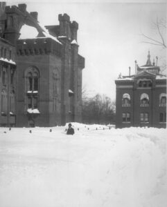
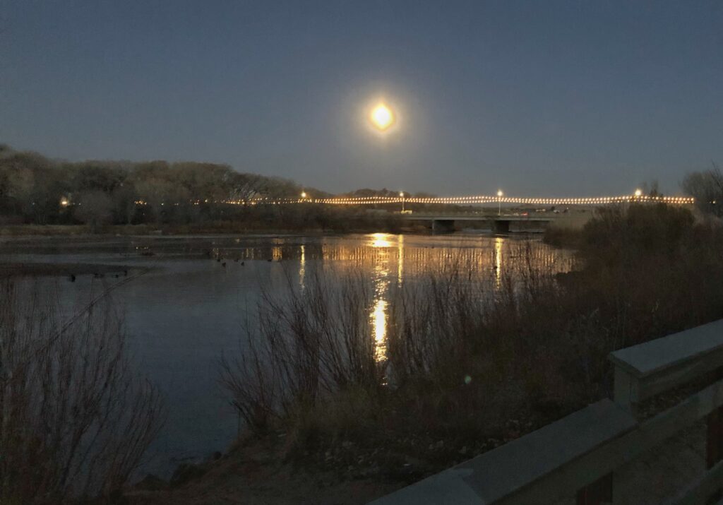
As the Colorado River Compact Commissioners gathered in Washington a century ago, a storm settled over the nation’s capital. Photo courtesy Smithsonian

Herbert Hoover’s words a century ago were chosen with care. Might it be possible, he wondered, for the state officials gathered around him that day “to agree upon a compact between the seven states of the Colorado Basin, providing for an equitable division of the water supply of the Colorado River”?

It was Thursday January 26th, 1922, at 10:00 AM, as the eight members of the Colorado River Commission met in Washington, D.C. gathered for the first time at the offices of the United States Department of Commerce. Over the next 11 months they would negotiate the details of the Colorado River Compact which they signed on November 24th, 1922.

“It is hoped that such an agreement,” Hoover added “… will prevent endless litigation which will inevitably arise in the conflict of states rights.”

Hoover, then the Secretary of Commerce, had been appointed by President Warren Harding to be the commissioner from the United States and lead the effort. In addition to Hoover, each state sent a commissioner appointed by its governor:

  • Arizona, W. S. Norviel, State Water Commissioner
  • California, W. F. McClure, State Engineer
  • Colorado, Delph E. Carpenter, Special Water Counsel
  • Nevada, Colonel James G. Scrugham, State Engineer
  • New Mexico, Steven B. Davis, State Supreme Court Justice
  • Utah, R. E. Caldwell, State Engineer
  • Wyoming, Frank C. Emerson, State Engineer

Hoover’s opening statement was carefully prepared.

While there is possibly ample water in the river for all purposes if adequate storage is undertaken, there is not a sufficient supply of water to meet all claims unless there is some definite program of water conservation.

In the language of the day, “conservation” meant something very different than its modern usage. It meant, quite simply, building dams to “conserve” water that would otherwise be “wasted” to the sea. But the enormity of the dams contemplated left an equally enormous institutional task – developing the rules needed to allocate, and therefore share, the river’s waters.

The Federal Role

As to the federal role, Hoover mentioned four interests:

  • control of navigation
  • protection of US treaty obligations
  • development of national irrigation projects
  • power development on public lands

“The sole object of the Federal Government,” Hoover said, “is to secure development of the river in the interest of all.” After his opening statement, Hoover was formally elected Commission Chairman.

The Commissioners Speak

Each of the state commissioners gave an opening statement.

Hoover first turned to Colorado’s Carpenter, acknowledging his role in the creation of the commission.  Agreeing with Hoover, Carpenter stated “the prime object of the creation of this Commission was to avoid future litigation among the states.” He added that “facts are always the basis of legal problems and hence the facts must be studied.”  The need to avoid litigation and study the facts was a common theme to the statements of all seven state commissioners.

The commissioners then heard from Arthur Powell Davis Director the U.S. Reclamation Service and nephew of the legendary John Wesley Powell. Davis, who began studying the Colorado River Basin in 1895, impressed the commissioners with his knowledge of the Colorado River. He emphasized Hoover’s conclusion that with conservation the river had a sufficient supply of water to irrigate all lands that could be “favorably reached.” Davis suggested the Commission could successfully apportion the river’s waters among the seven states based on the number of irrigable acres in each state. Over the next six meetings, they would pursue this approach without success.

The Commission then heard from representatives of the Army Corps of Engineers, the Federal Power Commission, and finally the U.S. Geologic Survey. In a short statement, Nathan Grover, Chief of the Hydrologic Branch, told the Commission that the resources of his agency were at their disposal.

What he did not mention was that his agencies’ Colorado River experts, including E.C. LaRue, did not share Davis’ optimistic view that there was enough water for all. Instead, they would have urged the Commission to be much more cautious and conservative in allocating the river’s waters.

Before the meeting ended, the Commission appointed committees to look at the legal issues, determine the water supply available, and ascertain the demands for water. They also tabled a proposal by Arizona’s Norviel to create a permanent commission. By the end of the first meeting, it was clear that four individuals would dominate the Commission. Herbert Hoover, the confident and self-assured mining engineer, took command of the effort from the first meeting, but too often chose expedient results over a thorough understanding of the facts. Delph Carpenter, the brilliant legal strategist and father of interstate water compacts, fearing the power of centralized government and the societal changes being driven by new technology, fought for state sovereignty in an increasingly complex interconnected world. Winfield Norviel, the tenacious Arizona Water Commissioner, understood that unlike the six other states, the Colorado River system was the only source of surface water for Arizona’s future, but his negotiating style alienated the other commissioners. Finally, Arthur Powell Davis, the hands-on engineer who understood that a peace pact among the states would open the door to the development of a new generation of massive water projects his agency would build and operate. Like Hoover, he wanted to avoid the Commission getting bogged down on the facts. Now, with Grover’s acquiescence, he controlled the facts the Commission would use.

The first meeting ended on a positive note. Although the Commission would soon find out how challenging it would be to turn broad concepts into agreement details, the optimistic view of the water supply put forth by Davis, Carpenter’s legal discipline, and Hoover’s pragmatism would ultimately prevail.

As an omen of the future turmoil facing the river, that evening Washington D.C. was hit with a record snowstorm. A Nor’easter lashed the region, dumping over 30 inches of snow on the city, enough that the weight of the snow caved in the roof of the Knickerbocker Theatre, killing nearly 100 people. The storm became known as the Knickerbocker storm.

The Commission held two short meetings on Friday January 27th, then got together again on Saturday January 28th to begin the real work of hammering out a compact.

Stay tuned.


Back in the days when the Salton Sea was rising

back when the Salton Sea was rising

A friend shared this, from the Sandia Lab News, circa 1955:

New Dyke Will Give Salton Sea Test Base Protection Against Rapidly Rising Water

The steadily rising water level of the Salton Sea in southern California is presenting a problem for the U.S. Atomic Energy Commission in seeking to safeguard test facilities operated by Sandia Corporation on the shores of the Sea.

Details here.

Is it too early to be optimistic about this year’s Rio Grande flow?

Yes.

But that’s not stopping me!

The Jan. 1 forecasts, courtesy of Angus Goodbody of the NRCS, for flows at Otowi (the head of New Mexico’s Middle Rio Grande Valley) and San Marcial (the tail) are for “normal” flows, where “normal” is defined now by the median of flows from 1991-2020.

Courtesy NRCS

The reason it’s definitely too early to be optimistic is that it’s just January! The remaining months in the winter snow accumulation season will either be wet, or they will be dry, and that will make all the difference. As Anne Marken, Water Operations Division Manager for the Middle Rio Grande Conservancy District, explained to the district’s board at yesterday afternoon’s meeting, “There’s a lot of winter left”.

There are a couple of good signs, though.

First, soil moisture in the headwaters region is substantially better than the previous two years, when dry soils and shallow aquifers took a big cut of the snowmelt before it ever got to the rivers. This is in part a result of a better 2021 monsoon season. (Click on the picture for a link to NRCS’s cool (new?) data map thingies).

Second, it’s actually snowed. The snowpack is not great, and has been concentrated along the western edge of the basin’s upper reaches, but it’s a pretty good start.

But see Marken’s “lot of winter left” comment.

A note on the data:

For “normals” for this sort of analysis, the water management/forecast/climate community uses the mean and/or median over a 30-year window. This shifts every ten years, and for 2022 we now need to become accustomed to the 1991-2020 time window, shifted for this year’s forecasts from the 1981-2010 window we’ve been using.

In dropping the relatively wet 1980s in favor of the relatively drier teens, we’ve got a drier “normal” against which to compared.

NRCS is also shifting its normal forecasting, the numbers Goodbody publishes each month, from using the mean for the reported “normal” to the median. Statistics nerds will understand that the median better reflects the central tendency for skewed datasets like runoff, but I am not one of those people so thinking through the difference and applying it to my runoff intuitions makes my head hurt. Thankfully the NRCS’s Goodbody (I think of him as our “forecast data concierge”) shared a great new tool for comparing the two time periods and two different measures of central tendency.


Why I ride

my 2021 rides in the heart of Albuquerque

In September 2019, my friend Scot and I did one of our more memorable “what happens if we turn here” bicycle rides.

In our endless search for what I call “longcuts” – the safest route, rather than the shortest – we followed a concrete flood control channel called the North Pino Arroyo up through Albuquerque’s far northeast heights.

As long as it’s not raining, it’s a super safe route, because no cars!

It also came with fascinating side effect. Below grade, lined with neighborhood back fences, the ride deprived us of our usual geographical cues – as close to being “lost” as is possible in a city with a mountain looming to the east and a river to the west.

We emerged in a park at the arroyo’s uphill terminus, with a general sense of where we were, but only the vaguest of ideas as to the specifics. We have a “no iPhone maps” rule on our rides, so the only way to get our bearings was to keep riding.

It was delightful.

“To become completely lost,” Kevin Lynch wrote in his 1960 book The Image of the City, “is perhaps a rather rare experience for most people in the modern city.”

I ride a lot, and I map all my rides. I’ve done that for years, since the first affordable, portable bike-mounted GPS gizmos became available. I used to ride a bunch of favorite roads and trails over and over, but in recent years, I’ve used the technology and a couple of cool web tools to think about where I haven’t ridden yet.

Map Games

2021 Albuquerque tiles ridden

One game, which goes by the name “tiling”, divides the world up into mappable tiles – think an entire globe covered with bingo squares. It’s based on Ben Lowe’s Veloviewer, one of a number of great indy web-based software platforms for this kind of stuff. (See Ride Every Tile for a window into the strange and wonderful world of tiling – my obsession is modest compared with some of the European tilers.)

The other game, which I began playing this year, uses Craig Durkin’s Wandrer. Wandrer ingests all your old GPS rides and gives you a map of roads you haven’t ridden. You can even download a map onto your bike GPS gizmo to see streets around you as you’re out riding.

This leads to a lot of cul-de-sacs and resulting dog-related adventures.

I’ve always been a bit wandery in my riding, and Veloviewer and Wandrer provide a fascinating structure around the thing. I’ll often plan a ride with a vague goal of an unridden tile and a map of unridden roads in the area. But I rarely end up doing what I intended. And why not? It’s a bike ride!

This year I’ve ridden:

  • 311 Veloviewer tiles, 103 Veloviewer that I’d never before visited
  • 5,044 miles, 572 on roads and trails I’d never before ridden

Why I ride

When I finally settled on setting the next book here in my “Middle Valley” rather than on the Lower Colorado River, one of the reasons on the “plus” side of the ledger was the ability to hop on my bike and ride to my “field area”. All this bike riding, what my friend Maria Lane labeled #geographybybike, involves the construction of intuitive maps of the landscape, hydrographic and human. The time from side yard bike shed to Rio Grande is 35 minutes – less if I need it.

Picking up new Veloviewer tiles and Wandrer miles creates a bit of a framework for expanding that mental map.

That’s true and all, but also maybe just a layer of excuse?

The neuroscientist and urbanist Robin Mazumder wrote a piece in 2019 that really captures why I ride. It’s about what psychologists call “flow”:

According to Jeanne Nakamura and Mihaly Csikszentmihalyi, flow involves the following elements:

  • Merging of action and awareness
  • Intense and focused concentration on what one is doing in the present moment
  • Loss of reflective self-consciousness
  • A sense that one can control one’s actions; that is, a sense that one can in principle deal with the situation because one knows how to respond to whatever happens next
  • Distortion of temporal experience (typically, a sense that time has passed faster than normal)
  • Experience of the activity as intrinsically rewarding, such that often the end goal is just an excuse for the process.

It’s not uncommon for me to return from a ride and have Lissa say, “You were gone a long time!” And I know that I was, because I have a watch and a phone and a GPS gizmo that all have been telling me this the whole time, and as a safety measure I’m always attentive to keeping Lissa posted on when she should expect my return.

But it doesn’t feel like a long time. The unfolding of a bike ride, the endless series of decisions (“What happens if I turn here?”), a gloriously unplanned “loss of reflective self-consciousness”.

When I started to write this post, I had a vague destination in mind, involving our mental maps and the benefit cycling provides to mine.

As often happens, that’s not quite where I ended up.


urban water conservation

fallowed vineyard, Albuquerque, New Mexico, December 2021

My newest hobby – running down the water story for random patches of Albuquerque.

From Sunday’s bike ride, a fallowed vineyard, a bit more than an acre in size.

It’s at the base of the sand hills on the east side of the Rio Grande Valley, just down the hill from a Ford dealer.

Per OpenET, it hasn’t been irrigated since at least 2016 (that’s as far back as I can look currently).

Doesn’t look like it has access to ditch water (it’s uphill from the closest irrigation, the Alameda Lateral). The nearest well is a state-approved yard well across the street, drilled in 1967.

Healthy crop of tumbleweeds this year. Per county assessor records, that seems to have been sufficient to claim agricultural property tax break.

But here’s the best part:

The three closest streets are named “Vineyard”, “Muscatel”, and “Tokay” (an Anglicization of “Tokaji” – wines from a region called Tokaj in Hungary and Slovakia).

Clearly, further research needed.