Federal Money and Rural America

Update: I was just waving my arms here, but a commenter who actually knows what s/he is talking about has stepped in with some valuable assistance. So skip my post below and just read this:

The data you’re looking for can be found here, at the county level: http://www.ers.usda.gov/briefing/ruraldevelopment/developments.htm

Like any data set, it’s open to interpretation. Overall, metro counties outperform nonmetro counties.

->You can break it down by region, to show that in the Northeast and South, urban areas outpace rural ones – while in the Midwest and the West, rural ones capture more federal dollars.

->You can try to differentiate transfers from procurement – that is, money the government redistributes from money the government spends to buy the things it needs. Defense dollars alone produce a $1k/capita rural/urban gap, because although many bases are rural, the real money goes to manufacturers, researchers, and health care. The same gap is visible using the more general ‘procurement’ category.

->But from where I sit, the most interesting difference is the three-part division between urbanized, less urban, and totally rural. Split things this way, and it’s a whole new ballgame. Counties that are genuinely rural – as opposed to, say, exurban – clearly outperform their urban and less urban counterparts. The same holds true for counties that are dependent on agriculture. And the two biggest single drivers are ‘grants’ and ‘direct payments other than for individuals.’ Rural counties aren’t capturing more dollars than urbanized counties just because their residents are older and poorer – those effects are actually fairly small (retirement/disability generates a $300 gap, and direct payments to individuals (EITC, UI) another $650). They’re capturing more dollars because they’re the beneficiaries of a variety of federal programs that target them for grants, bloc payments, and subsidies.

Really, this isn’t surprising. It’s also not seriously contested by economists. Rural areas enjoy outsize political clout, and they convert that into greater spending per capita. The gap would be even larger, but for the fact that these calculations include things the government buys, and most of those things are produced in urban areas.

Previously…


Warning: I’m operating totally outside my areas of journalistic expertise here, so this could be utter bullshit. More caveats to come. That said….

My friends at Stanford’s Rural West Inititative (disclosure – I’m sort of one of them) yesterday were linking off to a discussion of the potential effect of federal budget cuts on the rural United States. The Los Angeles Times kicked off the discussion with this:

The budget-cutting fervor in Washington is forcing lawmakers to reconsider not just the total amount they spend, but also where the dollars are going and why. The recipients with the most to lose are the ones in rural America, who are almost twice as reliant on federal largesse as city dwellers and suburbanites.

The folks at Daily Yonder clicked on the links in the Times piece and called the big urban paper out:

No matter how you look at it, rural “recipients” are not twice as reliant on transfer payments (medical benefits, Social Security, etc.). But, okay, rural residents are older and poorer, so they receive more of these transfer payments. Fine. This is a good point, even if the specifics are all messed up.

But then the Times conflates transfer payments with ALL federal spending. To tell you the truth, we can’t understand what the paper is saying. The paper says that “six of the 10 states where the federal government spent the most per capita are rural and people living on farms and in small towns collected 20% more on average in federal benefits than city dwellers.”

What the heck does that mean? What’s a “rural” state? (There are only five states in the country with a majority of residents living in rural counties after all.) Vermont is the most rural state in the country. Is Vermont on this list? We doubt it.

The Times original editorial is mostly about rural airport subsidies, which is one of those federal spending topics that leaves me feeling a bit like the drunk looking for his keys under the streetlight. By that I mean that it’s not very likely that we’ll find anything useful with regard to large scale systemic federal spending issues by studying the airport subsidy question. But hey, it’s all lit up over there, so why not give it a look?

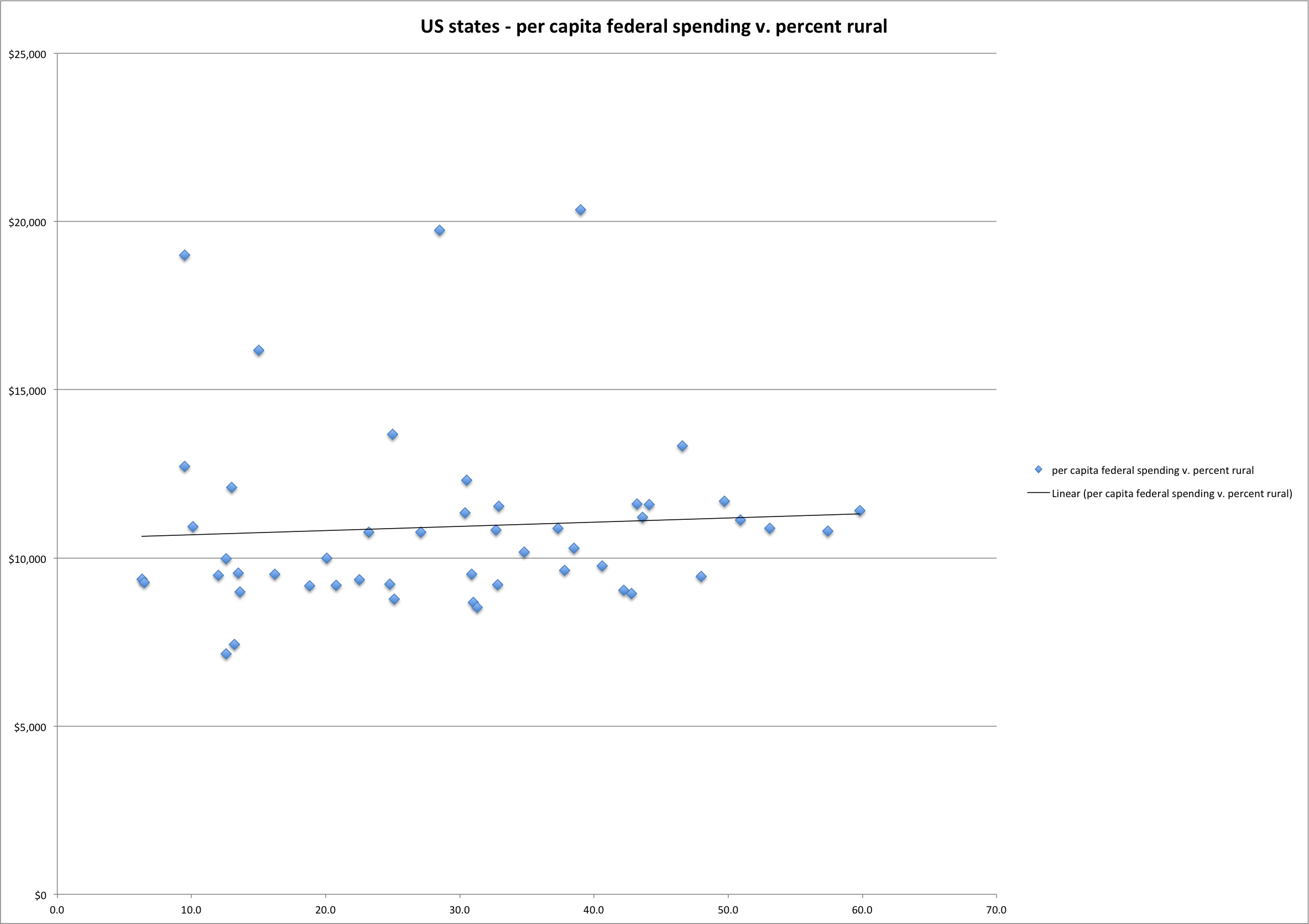
The thing is, to first approximation, this analysis is not at all hard. And the result seems to be that the rural-not rural divide has only an itsy bitsy relationship to per capita federal spending in the states:

Per capita spending compared to percent rural population

Per capita spending compared to percent rural population

That’s total per capita spending by state (the y axis) vs. percent rural population, with a linear fit thrown in. The four graphically obvious outliers (per capital federal spending greater than $15k) are Maryland and Virginia (DC spillover), Alaska and Hawaii (big defense dollars per capita, I guess ’cause you can see Russia and China from there or something). It’s a bit crude (the per capita spending data is from 2009, the most recent percent rural data I could find was from the 2000 Census), but that ought to be enough of a back-of-the-envelope calculation to suggest that the rural-urban divide among states explains very little of the variance in per capita federal spending.

Sources:

NB: For the newspaper, I spent a bunch of time last week looking at how the federal government spends money in New Mexico, so I think the underlying questions – who gets money now, and how that might change under the current “budget cutting” process. The (sub/ad req) column is here. But I’ve not really thought much in any rigorous way about the rural/urban federal spending divide, so this analysis may be totally pants.

Declining Colorado

Paul Miller and Tom Piechota have assembled a new set of data suggesting a decline in precipitation in the West, and more particularly in the basin that feeds the Colorado River.

For this work, they looked at SNOTEL stations, the network of snow measurement sites run by NRCS that feed data into streamflow forecasts. For the period of record at the various sites (which varies in length) they found:

  • 86 percent of the 398 sites around the western United States show decreasing water year precipitation
  • 87 percent of the 79 sites in the Colorado River Basin showed decreasing water year precipitation

It is important to note, as Miller and Piechota do, that the time series here is too short (less than 30 years in most cases, with few stations having data going back 40 years) to find statistical significance in the decline. But less precipitation is less precipitation.

Their data also point to another important characteristic. In recent years, for a given amount of peak snow water equivalent (essentially depth of snowpack), streamflow tends to be lower. Which is to say, less of what falls from the sky is ending up in the West’s rivers – a finding consistent with climate change projections.

h/t the the JAWRA blog for bringing this paper to my attention, and to the always-helpful Paul Miller for helping me understand what he and Tom had done.

Importantly, while the primary focus is on the Colorado River, Miller and Piechota also looked at the rest of the West, noting the interlocking water management systems via which we now share these problems.

Stuff I Wrote Elsewhere: Why my state is burning down

Richard White’s history of the extension of railroads across the western United States (Railroaded: The Transcontinentals and the Making of Modern America – great read) has fascinating excerpts from the 1870 diary of H.K. Thomas, the Union Pacific stationmaster in Laramie, Wyoming. The normal fires of summer in the mountains are mentioned twice – “covering the valley in a thick, smoky haze.”

In working over the past month on a newspaper piece about forest health and fire danger here, several people I interviewed talked about the central importance of getting us accustomed to smoke, so it seems normal, as it was in Thomas’s day. Why? Because fire really is a part of these systems, and its reintroduction is critical in the long run to getting forests healthy again and avoiding catastrophic, ecosystem-changing blazes.

From the Sunday Journal (sub/ad req):

Scientists say that before we started fighting fires, the woods here burned every three to 25 years, depending on location and forest type. Some fires hugged the ground, clearing needles and small trees and leaving large, fire-hardened trees to survive. Some fires were patchy, destroying one clump of trees and leaving others nearby intact.

In dry years, fire would sometimes roam across the landscape for months at a time, burning millions of acres, far more than we see today, Falk said. But it would burn lightly, leaving behind healthy open stands of forest.

Fire was a natural part of that system, he said. “Fire is something forest ecosystems do. It’s not something that happens to them.”

Putting out fires allows fuel to eventually build up to unsupportable levels. In addition, smaller trees create a pathway for fire to climb up into the tops of trees, which forecasters call a “fuel ladder,” allowing fire to take off. Something has to give.

Another La Nina?

Little Colorado headwaters near Springerville, AZ, a few years back when there was water

Shaun McKinnon has some numbers on this year’s Arizona runoff, and they aren’t pretty:

La Niña did a number on runoff down the Salt and Verde rivers this year — a low number, according to Salt River Project, which has released the final report on winter’s water yield.

For the 2011 runoff season, the two rivers delivered 223,916 acre-feet of water into the six reservoirsthat store water for metro Phoenix. That’s a little less than one-third of the long-term median runoff of 683,635 acre-feet for January -May and way down from 2010, when an unusually wet winter produced 1,418,960 acre-feet.

“But wait,” as Ron Popeil might have said. “If you act now, you also get, at no extra charge, another La Niña!”

[T]he latest runs from the NCEP Climate Forecast System (CFS) models predict La Niña to re-develop during the fall…. This forecast is also supported by the ongoing La Niña-like tropical atmosphere, subsurface temperature trends, and the historical tendency for significant wintertime La Niña episodes to be followed by relatively weaker La Niña episodes the following winter. Therefore, ENSO-neutral is expected to continue into the Northern Hemisphere fall 2011, with ENSO-neutral or La Niña equally likely thereafter.

Offer not available in stores.


Who Was Carl Rasch? The lawyer behind the Winters Doctrine

update: A previous version of this post had what I though was a picture of Carl Rasch. Upon inquiry, I think it was a black-and-white picture of some other old dude with a great mustache.

In answer to a question that came up in conversation on Twitter today, herewith an abbreviated version of the story of Carl Rasch, the attorney behind what is known as the Winters Doctrine, the legal principle that, to borrow the words of the late David Getches, ensured “the Indians got the best water rights” in the West.

Our story takes place in the Milk River Valley of Montana, dry hardscrabble land of the sort where many pioneering tales took root. The Fort Belknap Indian tribe used the Milk River for irrigation, sharing it with a number of small communities of European immigrants in the last 1800s. From Daniel McCool’s “Command of the Waters“:

The waters of the Milk River were the only dependable source to maintain these irrigation efforts. When settlers moved upstream from the reservation and began diverting water, the Indians were left with an insufficient supply.

In 1905 the U.S. Bureau of Indian Affairs, concerned about the Fort Belknap tribe’s loss of water, asked the U.S. attorney in Montana, Carl Rasch, to go to court to reclaim the water that the government felt should rightfully belong to the Indian irrigators. The key here was the “doctrine of prior appropriation” – the principle common in western U.S. water law that the first folks to use water have the first priority, and people can’t come later, move in upstream, and siphon it off.

But according to McCool’s account, Rasch wasn’t comfortable with the accounting, and was afraid that the upstream settlers may have really gotten there just ahead of the Indian irrigators he was supposed to protect. So Rasch filed a brief that left the door open to the U.S. government invoking other grounds for claiming dibs on the water for the Fort Belknap tribe, not merely the act of appropriating first. Which turns out to have been a good thing, because, as McCool tells the story, the settlers quickly produced evidence that they started taking water from the Milk River four days before the Indians.

Rasch’s cleverly open-ended legal strategy eventually led to a U.S. Supreme Court decision that found that Indians’ water rights priorities in the West date to the date their reservation was created, not the date they actually began using water on them.

I cheerfully recommend McCool’s book, Command of the Waters: Iron Triangles, Federal Water Development, and Indian Water, a great history of Indian water and federal water development.

And who was “Winters”? Therein lies another fun tale.

You can’t size your infrastructure for the outliers

Morganza spillway, Mississippi River

Morganza spillway, Mississippi River

Yesterday’s post about recurring suggestion that we build giant water infrastructure was premised in part on this year’s extremely wet year on the Missouri-Mississippi system, the “Why not build a big pipe from there to the desert” argument. As I mention, I hear this idea a lot, but especially this year, when it seems like there’s so much extra water over there that those folks don’t need.

OtPR nailed the problem with this argument in a post yesterday: “If you build for the peak, most of the time you’ll have excess capacity.” The case study at hand in OtPR’s post is a farmer who expanded to take advantage of this year’s extremely wet year, buying a bunch of extra equipment to put 500 marginal acres into production growing tomatoes:

But if Mr. Coburn bought a new tractor and harvester to support his most marginal 500 acres of land, he is so fucking stupid he deserves to lose his farm. Mr. Coburn knows from the past two years that he doesn’t get water for that acreage every year. How many wet years does he need to amortize $2M worth of equipment on 500 acres? Right now he’s burdened those 500 acres with $4,000 per acre worth of machinery, because in the wettest year in recent memory, he got some surplus water?

That argument applies across scales. If you build dams and canals capable of handling the big floods on the Mississippi, saving it and sending it to the arid West, most of the time they won’t be useful, because most of the time they’ll be empty. There are a whole lot of reasons I think the idea is a non-starter. This is one of them.

Drought? But it’s flooding on the Mississippi!

water in the wrong place

water in the wrong place

Nearly every time I write a newspaper story about water, and without fail every time I give a talk, I get a question about why we don’t just build a big canal from some wet place and bring the water here to the desert southwest.

It just seems so crazy to me – so over-the-top-engineering-costly-we-don’t-do-that-stuff-any-more crazy – that I don’t quite know how to explain why it’s not a practical idea. Can you say “NAWAPA“? But then there’s this, from one of the West’s leading water policy activators:

If innovative thinking is the key to solving Southern Nevada’s complex water puzzle, then Mulroy has a doozy of an idea. She suggests a massive public works project that not only could help relieve Colorado River Basin users but help solve the recurring problem of flooding in the Midwest.

“To me, it’s just counterintuitive,” she says. “One man’s flood-control project is another man’s water supply. You’ve got to remember that Hoover Dam was built as a flood-control project. That was its fundamental purpose: To prevent further flooding of the Imperial Valley down in Southern California.”

The idea is to build diversion dams for flood control and move the water to aquifers beneath the farmlands of Iowa, Nebraska, Kansas and Colorado. If Colorado farmers don’t have to use Colorado River Basin water for their crops, it makes more water available to downstream users, like us.

I mean, if Pat Mulroy thinks it’s worth trying, who am I to call the idea batshit crazy? (h/t Emily Green)

“We have a cool, pleasant ride today…”

Powell Expedition

Powell Expedition

My new favorite Twitter feed is @jwesleypowell, who is tweeting his trip down the Colorado River into the great unknown:

Soon after dinner, we discover the mouth of the San Juan, where we camp.

The tweets are drawn from the publicly published version of John Wesley Powell’s journals, which is a ripping good read. But it’s also a bit of a fiction, assembled after the trip, with some stitching up here and there.

It is in that regard helpful that a historian by the name of John Cooley has collected in one place all of the contemporaneous journals of the participants in the epic journey. “The Great Unknown” provides a useful adjunct to Powell’s gloss, as in this July 31 entry from George Braldey upon the group’s arrival at the mouth of the San Juan:

[T]place is most desolate and uninviting…. Fear Major will conclude to remain here and observe the eclipse on the 7th but sincerely hope not for to find shelter we have to crawl into the rocks and let the evelike projection of the cliff shelter us, and the rocks are almost hissing hot.

It wasn’t all biscuits and gravy.

(And in the manner of stitching, the above picture is actually from the second Powell expedition.)

Earth, air, fire and water

Ashy water in Rio Grande ditches, July 31, 2011

Ashy water in Rio Grande ditches, July 31, 2011

I tried my best while I was out riding this morning to get a picture that shows the strange discomfort flowing past in the Rio Grande and the irrigation ditches that flank the river as it passes through town. Need words to help – the water at this spot, on one of the ditches in Albuquerque’s south valley, is usually clear. It’s a spot where I often see a black-crown night heron fishing. Today, it was gunk.

The Las Conchas fire, which goes down as the “largest fire in New Mexico history” (more on the scare quotes later) was reported 99 percent contained this morning, meaning we’re almost done with it as fire. But it is monsoon season here, when fire’s aftermath turns to ash and mud and debris flows. As I wrote in Saturday’s paper (sub/ad req):

The runoff marks the latest wave of problems from one of the worst fire seasons in New Mexico history. While the fires and the damage they directly cause have drawn the most attention, experts say watershed damage is one of the biggest threats they pose in the long term.

Santa Fe and Albuquerque both shut down their drinking water river diversions. Albuquerque shifted to groundwater. Santa Fe has been forced to draw down reservoirs that were already perilously low because of the pitiful winter snowpack.

I wrote a piece a couple of weeks ago about the “new normal” as increasingly unhealthy forests and a changing climate create conditions that are ripe for this sort of fire year:

We are living in what some scientists have taken to calling the “Anthropocene,” a geologic era during which human influence dominates the landscape around us in ways that will be easily detectable long after we are gone. In the woods above Los Alamos, a big part of that influence dates to the arrival of the Chile Line trains in the late 1800s and the expansion of grazing animals that accompanied it.

“They ate all the grass,” McDowell said.

That grass provided the fuel for frequent, low-intensity surface fires that cleared out undergrowth while leaving the forest’s great Ponderosa pines intact.

Well-intentioned and effective but ultimately counter-productive efforts to snuff out every fire before it could spread added to the problems that finally blew up in the mountains bordering Los Alamos and Santa Clara Pueblo in the last two-plus weeks.

But I feel like I’m only scratching the surface. I didn’t touch the issue of water and watersheds in the “new normal” piece, and I’m only beginning to understand the forest health issues that are driving all of this.

Albuquerque’s Rio Grande drinking water system is back up as of Friday, and Santa Fe hopes to get going next week, two more steps toward an uncomfortable normalcy.