Eric Kuhn on less water

Eric Kuhn:

One hundred years ago, we had some flexibility because the river was not very well-used. Today, not a drop of the Colorado River reaches the Gulf of California, so we don’t have that luxury. The way I look at it is: we legally allocated water based on an assumption that this river system had about 20 million acre-feet. Today, we think it’s more like 13, and it might be less in the future with climate change. Predictions and models show that increasing temperatures are going to reduce flows to the Colorado River. The drama is not how much water we’re going to have in the future — we know it’s going to be less. The drama is how we’re going to decide who gets less water, and when.

Clearing the institutional logjam to allow (some small amount of) NM Rio Grande storage in 2022

Ok, the logjam isn’t cleared yet, but we can see how the clearing will happen.

Also, it’s not really Rio Grande storage, it’s the Rio Chama. But it’s a tributary to the Rio Grande. Headline writer’s prerogative.

The deal is that El Vado Reservoir on the Chama, where central New Mexico stores its irrigation water, is about to undergo repairs. Abiquiu Reservoir, just downstream, has been discussed for a while as an alternative storage site. But it’s a Corps of Engineers dam, with different rules for whose water can be stored there, when, and for what purposes.

The instititutional chit-chatting about this has been going on for a while, but we’ve been growing nail-bitingly close to May, when the work on El Vado is set to begin.

Happy to report that we now have a draft National Envirornmental Policy Act analysis from the Corps which seems to have arrived in time for the actual storage of water to begin on time.

Comments being accepted through April 4.

Brad Udall on the Drying of the Colorado River Basin

The Drying of the Colorado River Basin, slide from Brad Udall

The only lever we currently control is the demand lever.

– Brad Udall, Stegner Colorado River Symposium, March 18, 2022

Colorado State University climate researcher Brad Udall poked again last week at a question he’s been thinking and speaking about for the past year – the knock-on effects of summer warming in the Colorado River Basin.

Precipitation declines in late spring and summer, combined with summer warming, are leaving us with dry soils as we head into the winters that follow. Which means less runoff in the basin.

His talk included a graph of new modeling being done by a group of Colorado River researchers. Under a continuation of the hydrology we’ve had for the past two decades, the total storage of Lake Mead and Lake Powell bumps along at basically empty for the foreseeable future.

And Brad, a scientist whose work more than most straddles the scientific and policy worlds, shared his “biggest fear” – that it’s easier for basin managers to let the system crash than to make the hard choices needed to avoid that crash.

Colorado River Compact at 100; Lake Powell at 3,524.42

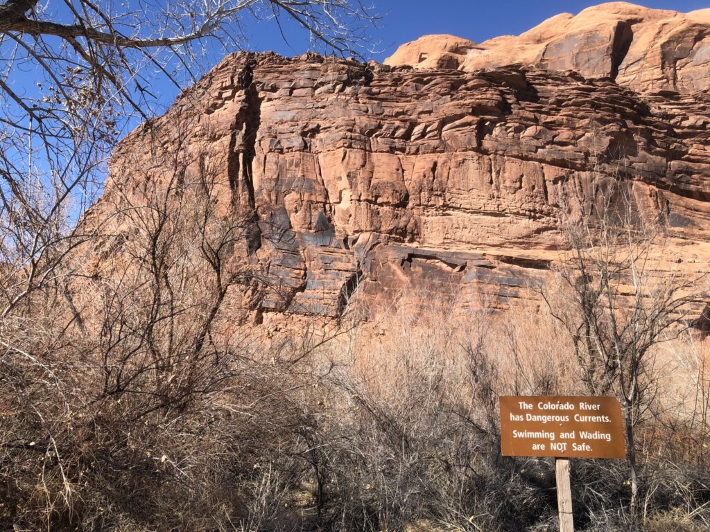
The Colorado River has dangerous currents. Moab, March 2022, photo by John Fleck

The most interesting news at this week’s University of Utah Stegner Symposium on the Colorado River Compact, past and future may be the news that we didn’t hear.

It was an amazing gathering, bringing together pointy headed academics like me with most of the basin management leadership team from tribes, state and local agencies, and the federal government. The crisis situation on the river made for some pointed conversations.

The news we did hear was stark:

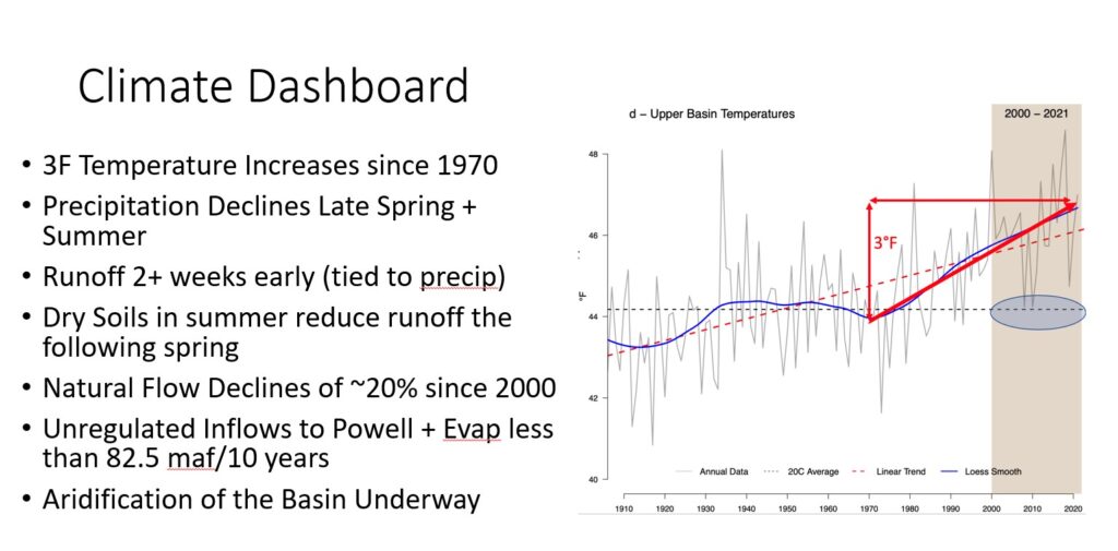
  • Colorado River Basin water users are currently consuming 14-15 million acre feet of water from a river that for the 21st century has averaged 12.3 million acre feet. Several water users suggested a need to be ready for that to continue to drop – 11maf? 9?
  • Reclamation is scrambling to figure out how to safely move water through Glen Canyon Dam as Lake Powell dips below the safety threshold elevation of 3,525 feet above sea level, creeping toward “minimum power pool” – lowest since filling in the 1960s.
  • Summer drying is making it harder for snowpack the following winter to make it to headwaters rivers.
  • Declining river flows have us staring down a fundamental conflict, rooted in the century-old Colorado River Compact, about how much water upstream users are required to pass downstream past Glen Canyon Dam each year.
  • Unresolved Native American water rights – some rights that exist on paper but aren’t being used, some not yet even quantified – have us on a collision course with fundamental legal and moral questions about equity as non-Indian users risk crashing the system while Native Communities have not yet had the chance to use water to which they have long been entitleld.

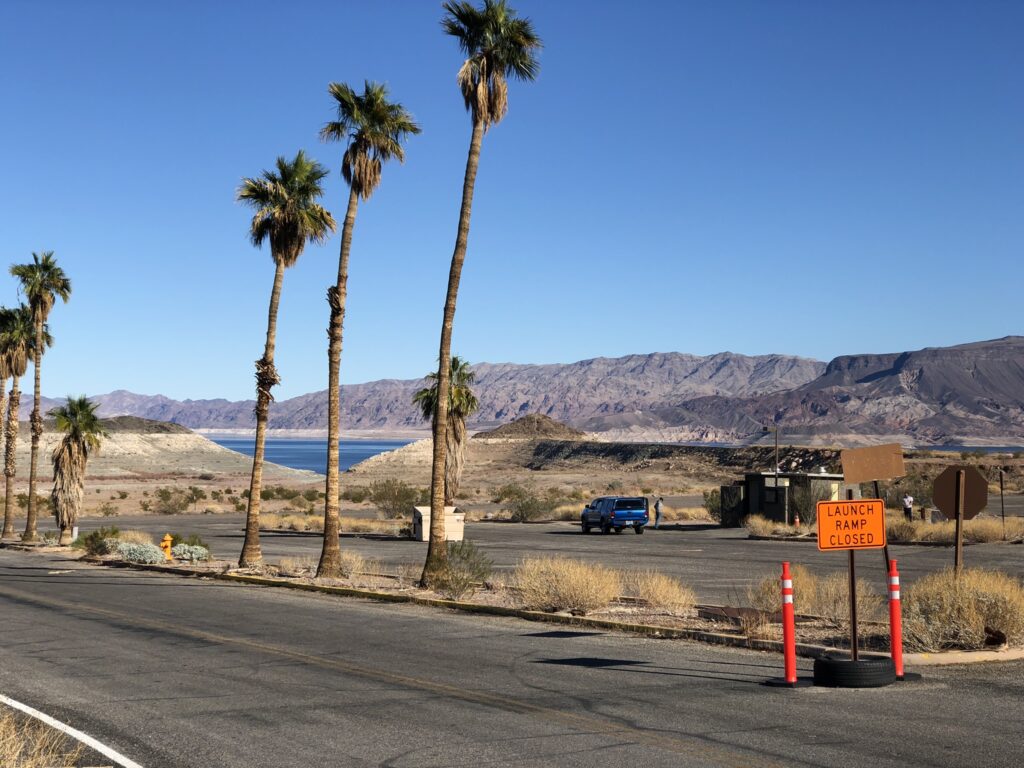
The news we didn’t hear – Las Vegas is not at risk of losing its water supply

Here’s what we didn’t hear: Las Vegas, Nevada, is not at risk of losing its water supply as Lake Mead’s levels drop toward Vegas’s intake pipes.

Was a time when the Las Vegas intake system was vulnerable as Lake Mead’s elevation dropped toward elevation 1,050. But years of planning and an expenditure of some $1.5b have the Southern Nevada community equipped with new intakes deeper in the reservoir, and a new pumping plant that is now scheduled to be flipped on for the first time later this spring as Lake Mead’s elevations drop toward elevation 1,060.

Turning on those pumps, designed to keep the water flowing to Las Vegas at the sort of elevations we’re now seeing, is a huge milestone, reflecting a community that took low probability/high consequence risk seriously and invested heavily in mitigation.

The low probability event is happening, the high consequences are not.

With Reclamation’s current “most probable” forecast showing Mead headed toward 1,035 in 2023, with a clear possibility of dropping into the 1,020s over the next 18 months, it’s fascinating to think about what the basin conversation would be like right now if the Southern Nevada Water Authority hadn’t built its “third straw”.

A few notes below on discussions that attracted my attention over the two-plus days of symposium sessions and the critical conversations in hallways, at dinners, and in hotel bars.

The integrity of Glen Canyon Dam

Assistant Secretary Tanya Trujillo was blunt about the risks as Lake Powell continues to drop. Under normal operating conditions, water is released through penstocks that drive turbines to generate electricity. But somewhere around elevation 3,490 (or maybe higher?), that becomes infeasible, first because of the risk to the turbines if air gets entrained in the inflows and second because at some point it’s physically impossible to get water out throught that door.

At that point, Reclamation is left with Glen Canyon Dam’s low elevation bypass tubes. Their use poses, in Tanya’s words, many operational uncertainties. Aside from testing and early filling days when the dam was built in the 1960s, they’ve only been used briefly during flooding in the 1980s, and during the relatively short-term high-flow experiments as part of the Glen Canyon Dam LTEMP.

Tanya continued to emphasize Reclamation’s statutory obligation to protect the integrity of the dam, something she also did in her public remarks at the December CRWUA meeting – the Colorado River Water Users Association. She said Reclamation may need to reduce annual flows from Glen Canyon Dam to protect the infrastructure.

That’s a big deal. In hallway conversations and side meetings, there was apparently significant conversation among state and federal officials about how all that might happen.

How small a Colorado River should we prepare for? 11maf? 9maf?

Southern Nevada Water Authority’s John Entsminger described how his agency’s long run planning includes a worst-case “what if” of an 11 million acre foot river. Recall that it’s been a 12.3maf river in the 21st century, which has been enough to drain the reservoirs. This would be worse. At 11 maf, Entsminger said, his agency’s modeling shows Mead bumping round 900 feet in elevation, while Powell is basically empty.

“The future of the Colorado River is pain,” Entsminger said. “Anyone who tells you anything different is selling something.”

Andy Mueller, from western Colorado’s Colorado River Water Conservation District saw Entsminger’s 11maf bet and raised (lowered?) him another 2 million acre feet, saying we need a plan in place to deal with the possibility of a 9 million acre foot Colorado River.

You shouldn’t see this as a disagreement between Andy and John. You should see this as a disagreement between the two of them and a bunch of other people in the basin. Last year’s Getches-Wilkinson Center conference in Boulder, for example, included a noteworthy exchange between Entsminger and New Mexico’s then-State Engineer John D’Antonio in which Entsmber suggested the need to prepare for an 11 million acre foot river and D’Antonio’s suggest that 13-14 maf is a more realistic planning baseline.

Consider what we might do with an 11 million acre foot river (never mind 9!). This is a world, under current operating rules, with likely cutbacks in the Upper Basin, a frequently dry Central Arizona Project canal, and difficult contestation over what the river’s operating rules really mean in a world far different from the one the Compact’s drafters thought they were in a century ago.

A quip from Arizona Tom Buschatzke suggests how hard these conversastions will be. “I won’t say I agree to 11,” Tom said in one of the many moments of remarkable frankness we saw over the two days of the symposium, “or I might get arrested when I get off the plane in Phoenix.”

Equities – tribal water

It is noteworthy that the symposium, one of the most important events during this year’s Colorado River Compact centennial, was co-sponsored by the Water and Tribes Intiative, an effort to expand the basin’s water management discourse.

The impact on our First People of our nation’s colonial history is profound. How to come to terms, in the area of water management, with that impact becomes an increasingly urgent question as the river shrinks. We have tribes with:

  • legal rights to water now being put to use
  • legal rights to water on paper that are not yet being put to wet water use
  • unquantified rights

(see here from the Water and Tribes Initiative for more details)

We heard lots of positive discussion at the symposium about the recognition of this question, with tribal leaders (most notably Daryl Vigil from Jicarilla in New Mexico) and their representatives (especially Margaret Vick and Jay Weiner, two of the most prominent tribal attorneys, who play crucial briding roles between tribes and the water management law and policy plumbing). The question is how that talk translates into substantive roles for the basin’s 30 tribal sovereigns.

One key thing to watch: We’ve seen tribes playing an increasingly important role in the use of their currently used apportionments in helping solve basin problems. Will the discussions expand to compensation to tribes for the forebearance of the use of water not currently being put to use?

The tribal equity questions are far broader, but this question of whether compensation for forebearance is on or off the table is a test worth watching.

Equities – Upper Basin

My pal and coauthor Eric Kuhn gave an entirely too short presentation (I know because he shared the draft white paper version of the background with a bunch of us before the meeting) on the Upper Basin-Lower Basin equity issues embedded in a Compact that seems to set fixed deliver obligations at Lee Ferry regardless of what the climate is doing.

That fixed obligation would seem to place most of the climate change burden on the Upper Basin – no matter how much the river shrinks, we have to send 7.5 million acre feet per year (or, depending on one’s interpretation of unresolved legal questions, 8.25 maf) downstream.

Conversations about relaxing that Lee Ferry delivery obligation will be among the most difficult in coming years, but Eric argues it’s the only way to resolve this fundamental equity problem embedded in the 1922 Colorado River Compact.

“We need to manage the river we have today,” he said, “not the one we thought we had a hundred years ago.”

What are we thinking about when we think about Colorado River water management?

In light of today’s dire situation on the Colorado River, it’s interesting to return to the basic conceptual structure of the “2007 Interim Guidelines” – the rulebook for today’s river management.

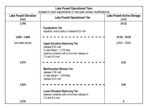
The heart of the “interim Guidelines”

They include this crazy table. (There exist more graphically neato versions, but I think it’s worth going to the source.)

It defines a complex nested set of “if this then that” rules for determining how much water is released from Lake Powell each year. All the “ifs” refer to the elevation of Lake Powell and Lake Mead, the two giant reservoirs at the heart of the system. We are currently operating in the “Lower Elevation Balancing Tier”, which creates all kinds of crazy incentives. If the Upper Basin puts more water into Powell, some of that will end up being released to Mead under the rules. If the Lower Basin foregoes some water use to prop up Mead, under the rules that could trigger smaller releases from Powell.

This reflects a basic paradigm in Colorado River management – decisions made on the basis not of flow in the river but rather on the basis of water in the reservoirs.

This is because those reservoirs – the water they store, really – have been for nearly a century central to the project of building a hydraulic empire that is the West we all know and love. As one of my other pals and coauthors, Anne Castle, noted, they’ve been enormously valuable in helping with that task.

But that was then. Now?

“They don’t do us much good,” Anne said, “when they’re empty.”

This is why Southern Nevada’s construction of the third straw looks so smart in 2022. Down to a nearly empty Lake Mead, Las Vegas will still be able to get water.


3,525

Colorado River, Potash Boat Ramp (downstream from Moab), March 15, 2022. Photo by John Fleck

I’d just turned my bike onto the old potash mine road out of Moab, down the Colorado River, this morning when a friend texted me a picture of a digital readout on a wall that I presume to be deep in the bowels of Glen Canyon Dam:

WATER LEVEL 525

The “3” goes without saying, I guess? The elevation of the Colorado River at the base of Glen Canyon Dam is 3,132 feet above sea level, so the elevation of Lake Powell is always in the 3,000s.

So 3,525 it is.

To my left as I stopped to read the text message, the Colorado River flowed serenely downstream, headed into a gap in the red-rock cliffs, with little apparent care for the affairs of humans.

I’m taking a leisurely few days on my way to Salt Lake City for this week’s Stegner Center symposium on the centennial of the Colorado River Compact, with some extra days for long bike rides on the way up – Sunday on the San Juan through the northeastern edge of the Navajo Nation, today in Moab on the Colorado, and tomorrow a bit of time along the Green – the Colorado River’s three great strands.

I didn’t plan to be in Moab, where the Colorado River enters the Canyon Country of Lake Powell and Glen Canyon Dam, on the day Powell dropped through the arbitrarily magic level of elevation 3,525. You can’t plan stuff like that.

From a young age, all I ever really wanted to do was write about this river. I think I must have been a teenager when, on one of our annual summer car camping expeditions (early 1970s?) my parents bought me Michael Collier’s book An Introduction to Grand Canyon Geology. And I remember not just being interested in the geology, and the Grand Canyon, and the river, but in Collier.

Books are written by people, and I wanted to be one of those people.

Potash Road was a delight, 40-ish miles of out-and-back flat road with an up-canyon tailwind for the ride home. It was in the 30s when I started, but by afternoon I’d peeled the layers down to shorts – first shorts ride of 2022. I took my new bike, which is not really a new bike so much as the latest remodeling job on one of my old bikes done by my friends at Two Wheel Drive.

built for leisure

The new bike is built for leisure, and can handle a bit of dirt.

When the states of the Colorado River Basin were developing their Drought Contingency Plan, they set elevation 3,525 as a soft line, to leave a buffer above the critical elevation of 3,490, which is where Glen Canyon Dam’s power generating gizmos start to get wonky. Even that isn’t a firm line,  as Luke Runyon points out.

Cavitation.

Uncharted territory.

In 2019, I wrote a bit of business that’s getting a fresh burst of traffic as Lake Powell enters the great unknown. At the time I wrote it, Lake Powell’s elevation had stabilized after the big crash of the early 21st century, but people were worried:

It certainly would be correct, and is important to note, that a repeat of the drought of the early ’00s would be disastrous. Absent changes in management, it would lead us to dead pool. It is important to have policies in place that are ready for that.

We are, in fact, now in the third year of a “repeat of the drought of the early ’00s”, and beyond the Hail Mary of sending a bunch of water downstream from Flaming Gorge, I don’t see the policies in place that are ready for that.

On my languid bike ride down Potash Road today, I stopped at a particularly memorable pullout to have one of my peanut butter and jelly sandwiches (the “new bike” has panniers, the better to carry large quantities of food, in addition to stashing peeled layers of clothing). The river was low, exposing a sandbar across the way, backed up by a thicket of tamarisk, backed up by what I presume to have been an old Pleistocene bench – ancient deposits of sands and gravels (forgive me, Jack, if I’m mucking up the geomorphological story, I love to say “Pleistocene bench”).

It was a reminder that the river is operating on different time scales than we are, a point I remember Collier’s book making to teenage John in a way that has stuck to this day.

Getting Acquainted with the Colorado River Basin: 100 years ago in compact negotiations

Looking down stream towards Boulder Canyon. Photo by E.C. Kolb – 1923. Courtesy USGS

By Eric Kuhn and John Fleck

The Colorado Commissions’ 8th Meeting
Wednesday, March 15th, 1922, Phoenix, Arizona

After a six-week break from the disappointing series of negotiating meetings that ended on January 31st  in Washington, D.C., the commissioners from the seven U.S. Colorado River Basin states and the federal government reconvened for the group’s 8th meeting on March 15th, in Phoenix, Arizona at the Federal Building. The commission’s goal for the Phoenix meeting was not to return to the stalled negotiations. Instead, at Hoover’s recommendation, the commissioners and their advisors planned to visit the Colorado River Basin to learn about the basin, hold a series of public meetings, and tour the proposed Boulder Canyon Dam site and the Imperial Valley.

Learning about the basin

One might think that all the commissioners were experts on the Colorado River Basin, but the reality was that only one of the commissioners, Arizona’s Norviel, lived and worked in the basin. The remainder were highly skilled professionals, but their knowledge of the Colorado River Basin was primarily limited to the states they represented. The Colorado River Basin of the early 1920s was a vast expanse of primarily rural Native American and settler communities. There were few improved roads. Transportation was primarily by railroad, and even that was limited to a few east-west corridors. Communication was by telegraph and mail. While residential electric and telephone services were being rapidly installed in the larger urban centers adjacent to the basin, like Denver and Salt Lake City, and a few of the larger communities within the basin, like Phoenix, it would be decades before these basic services were commonly available for most of the basin.

Mining and agriculture were the primary drivers of the basin’s economy. Of the two, agriculture was much more stable. Arthur Powell Davis’ Reclamation Service was already a major development force.  The Service brought with it the federal government’s financial and technical resources necessary to build large scale projects that the local communities could not hope to build with their own resources. These projects, like the Yuma and Salt River Projects in Arizona and the Uncompahgre and Grand Valley Projects in Western Colorado, provided reliable water supplies to irrigate hundreds of thousands of acres of mostly desert lands. The projects also brought new problems to the basin. Their success led to a desire by communities and promoters throughout the basin for Reclamation to build more. Further, the existing and proposed projects were large enough to have a major impact on the flow of the river. Without a compact among basin states, legal and political conflicts over which projects got the river’s waters and federal dollars were guaranteed.

First stop: Phoenix

The commissioners’ first stop was Phoenix. Today it is the 5th largest city in the United States with a population of 1.61 million – 4.5 million if you include the greater Phoenix metro area of Maricopa County. In 1920 Phoenix’s population was just 48,000 – 90,000 in Maricopa County as a whole. In 1922, Phoenix’s Valley of the Sun was dominated by irrigated agriculture. Today, while many are surprised at the scope of the region’s remaining agriculture, irrigated acreage has long been in decline, with much of that farming replaced by a sprawling metropolis.

The commission held four public hearing sessions and a business meeting where it discussed logistics and a letter from the Federal Power Commission requesting guidance on how to proceed with an application by a private individual to build a power dam at Diamond Creek in what is now the Grand Canyon. That proposed power plant – the Girand Project – highlighted the frictions within the basin. The project, which had been pending before the Power Commission for several years, had broad support from Arizona’s mining community and political leaders but was opposed by the other states and Davis. The upper river states were opposed because it could create a legal call on the river impacting upstream development. Davis and California were opposed because it could interfere with the development of the Boulder Canyon Project. The commission failed to reach a consensus on a response.

The commission held four lively public in Phoenix meetings over three days. Among the presenters were two strong-willed individuals who would have a major impact on the river’s future: irrigation promoter George Maxwell and Los Angeles Water and Power boss William Mulholland.

Maxwell’s Arizona vision

George Maxwell, picture courtesy Arizona State Library

Maxwell was promoting what was referred to as the Arizona Highline Canal, a project that would divert large amounts of water (perhaps 8 million acre-feet per year) from the river in the Western Grand Canyon, then convey it through 450 miles of pumping plants, tunnels, and canals to Central Arizona where it would irrigate 2.5 million acres of new lands. Maxwell sparred with Davis and the commission members, most of whom considered his project unfeasible. Maxwell feared that the commission would agree to a compact that would leave Arizona with too little water. Further, he opposed the construction of a large storage reservoir at Boulder Canyon. Instead, he supported a large reservoir in Glen Canyon coupled with a power/diversion dam near Diamond Creek and a flood control reservoir at Bullhead (now Davis Dam). Although Maxwell had little success in influencing the compact negotiators, his dream to move water from the mainstem to Central Arizona ultimately became today’s Central Arizona Project.

Mulholland’s California head fake

Mulholland, architect of the 220-mile-long Los Angeles Aqueduct, which moves water from the eastern Sierras to Los Angeles, chose to meet with the commission in Arizona rather than in his native Los Angeles. In a message aimed at the Arizonans as much as the commissioners, he testified that his city was not interested in water from the river. Rather, it needed the hydroelectric power of a Boulder Canyon project and was more than willing to pay for it. It may have been a head fake. In 1924, under Mulholland’s leadership, Los Angeles formalized its plans to build a new aqueduct from the Colorado River and in 1927 he helped form the Metropolitan Water District of Southern California, the entity that built and operates the Colorado River Aqueduct. In 1931 Metropolitan and Los Angeles became the two largest purchasers of Hoover Dam power.

On to Las Vegas and Boulder Canyon

Las Vegas, NV, station in the 1920s. Photo courtesy UNLV Libraries

On Friday afternoon, March 17th, the Colorado River Commission members, and their advisors packed their bags for an overnight trip to the small community of Las Vegas, Nevada to tour the Boulder Canyon Project site. Today the Las Vegas area has a population of 2.3 million. In 1922, with a population of only 2,300, it was so small that Nevada’s Commissioner Scrugham didn’t believe it was necessary for the commission to hold a public hearing.

On Saturday, March 18th, the commission toured the Boulder and Black Canyon dam sites, then set off on another overnight journey to see the Imperial Valley.

thoughts on UNM’s Water Resources Program and the importance of interdiscliplinarity

The Rhythm of Water, a 2013 mural by Eric J. Garcia and a ton of other folks, Atrisco (Albuquerque), New Mexico

tl;dr – We’ve got a bunch of really interesting interdisciplinary work underway at the University of New Mexico’s Water Resources Program. If you know someone finishing their undergraduate work or early in their career, interested in water work beyond the solely sciency/engineering paths, send them our way!

longer

water as art, art as water

It’s weird, but now that I’m no longer the director of the University of New Mexico Water Resources Program, I actually have more time to think about the academic and intellectual task of water management.

And, for a variety of reasons, I’ve been thinking a lot about the task of interdisciplinarity in water management.

The biggest reason is a pretty intense ongoing conversation with one of our students who’s just finishing up their degree, and who has started working for a very progressive water agency that understands that the task of managing water extends far beyond the physical science and technical questions involved.

In my transition to work at the Utton Center, a natural resource group at the UNM School of Law, I’m continuing to work with a bunch of Water Resources Program students, and I’ll still be teaching the fall introductory course with my colleague and collaborator Bob Berrens.

My new life, shorn of administrative responsibilities, gives me more time to think about this stuff, and engage in the deeper conversations with our students that are the most treasured part of the gig. Bob and I seem to have inadvertently assembled a critical mass of really talented students helping us think about the core question we pose in our fall course:

There’s less water. What do we do?

This is not solely, or even primarily, a technical question.

In an interview earlier this month in Vox, geographer Edward Carr said this:

There are going to be certain situations we can’t just throw money at or build infrastructure for. We’re going to have to make decisions about what we want to preserve and what we’re willing to give away, what’s essential to us, and what do we keep? That’s a social choice and that’s a political choice. Our political systems, the way that we interact with each other, and the way that we identify problems and solutions — all of that becomes central to how we will function in the face of climate change.

The stuff our students are working on now is super exciting:

  • Tax policy (who knew tax policy had such important implications for how we use irrigation water in New Mexico? Stay tuned, much more on this soon….)
  • The benefits and costs and implications of water use transfers from rural irrigation to municipal use
  • The environmental and cultural implications of land fallowing – whether because of transfers, or because the water just ain’t there
  • Some unexpected agricultural crop-shifting responses to climate change
  • The community and cultural value of non-commercial irrigation (and the risks to these values posed by climate change)
  • A re-evaluation of ecosystem goods and services of the Rio Grande and the irrigation systems around the river here in central New Mexico

Some of this is funded through UNM’s participation in the South Central Climate Adaptation Center, some of it’s now supported through my work at Utton, and some of it’s just the stuff that we do as part of the degree-granting process.

Underpinning all of this is a recognition that “water management” is not solely a technical question, to be left to engineers and physical scientists, and is why I so treasure the interdisciplinary nature of the Water Resources Program.

If you know some bright young person interested in an interdisciplinary perspective on water management, encourage them to contact me. I’m no longer the director, but I can talk about the stuff our group is working on, and connect them with the current program leadership.

When they thought the Salton Sea would bring New Mexico rain

Albuquerque Journal, March 11, 1907

The members of the Cattle and Horse Protective association of New Mexico, composed of men who are naturally deeply interested in a copious rainfall, believe that the Salton sea has given New Mexico a better climate. At any rate they want the matter investigated before Uncle Sam dykes up the Colorado river permanently.

– Albuquerque Journal, March 11, 1907

This came as the Colorado River was pouring through the gap inadvertently created by Charles Rockwood’s undercapitalized Imperial Valley irrigation efforts, turning north to fill the Salton Sink.

the pinto bean

pinto beans in Albuquerque’s South Valley

Unfortunately Quality Baits was closed when we passed on our Sunday morning bike ride, which is too bad.

They have pinto beans.

For the new book, I’m trying to get my head around Albuquerque in 1918. For reasons I don’t yet fully understand, pinto beans were a very big deal in 1918.

Albuquerque’s Chamber of  Commerce that year was leading the pinto bean charge. From the Albuquerque Morning Journal, June 10, 1918:

“Beans and drainage are the two best bets in New Mexico today,” is the opinion which is being freely expressed by many local business men and land owners. The present time is believe to be a crucial one for the bean grower.

Beans have been a part of New Mexico’s agricultural heritage from time immemorial, a crop native to North America that played an central role in the subsistence farming of indigenous communities. But the Chamber of Commerce in 1918 wasn’t talking about growing food to eat here. They were trying to hitch Albuquerque’s economic future to pinto beans as an export crop.

You can understand their enthusiasm, given the general awesomeness of pinto beans.

Their scheme for sharing this enthusiasm to economic ends was postcards. The Albuquerque Chamber of Commerce was going to work with the federal government, which would produce postcards about the awesomeness of pinto beans, which Albuquerque residents would send to their families back east. From the Feb. 20, 1918 Albuquerque Morning Journal:

“A two-cent stamp on such a postcard would make more pinto-converts in the east than two dollars spent in ordinary impersonal advertising,” said Secretary Aldo Leopold of the Chamber of Commerce yesterday. “It would also remind the New Mexico citizen that charity begins at home, and that if he does not eat pintos he is neglecting an opportunity to benefit both himself and his state.”

Yes, that Aldo Leopold. 1918 was the year he, as secretary of the Albuquerque Chamber of Commerce, organized a conference on the issue of drainage of the land on Albuquerque’s valley floor. High water tables and swampy land have always been a problem here, but it was getting worse. Drainage was the fix, and the rhetoric of the day suggested that with drainage New Mexico’s Middle Rio Grande Valley could be richly agriculturally productive – not in the traditional subsistence ways long practiced in the valley, but with export crops.

I’m a little unclear on whether the postcard scheme was actually implemented – I found later references to a distribution of stickers. More work needed. But what’s interesting is where pinto beans fit into the long, circuitous history of agriculture in the New Mexico’s Middle Rio Grande Valley.

The list of crops touted as the valley’s agricultural future is long – sugar beets, pinto beans, large-scale wheat, tomatoes, even tobacco. All failed.

In the 1919 agricultural census, we can see a pattern that very closely matches what we see in the valley today: more than 3,000 acres of alfalfa, just 134 of beans in Bernalillo County. People have tried lots of things, but alfalfa has always been the main crop that really works here.

What’s interesting to me here is not so much the failure of pinto beans as a middle valley crop. It’s Leopold. He’d left Albuquerque by the time the Middle Rio Grande Conservancy District began digging the ditches through the valley’s lowlands that provide drainage even today. But his mark on that crucial process, so important in making Albuquerque the city it is today, remains profound.

The thing that’s most interesting, and that became a central piece of the work that brough him such renown, is the sense of civic responsibility, of collective action for the common good. That’s why I love the postcards (or stickers?) and the argument behind them.

Aldo seems to have practice what he preached. His charmingly meticulous 1920 garden plan for the family home on 14th St. SE here in Albuquerque includes “beans”, over near the cabbage, lettuce, and beets.

Not sure if they were pintos.