When is a forecast not a forecast?

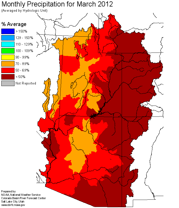
I had to laugh when I looked at today’s long-lead precipitation forecasts from the Climate Prediction Center.

Those little splotches of color are forecasts. All that white is what the forecasters call “equal chances”, which basically means they have no idea other than historical climatology what might happen. In other words, it could be wet, or it also is possible that it might be dry. Or maybe, just maybe, somewhere in the middle.

Long lead forecast, April 19 2012

Long lead forecast, April 19 2012

Forecasting is hard.

A border water fight – not over how much, but rather when

We’ve got a fascinating border water fight going on between Mexico and irrigators in the United States over water from the Rio Grande right now. But rather than the usual issue – who gets how much – this one’s over when the water is used.

Under US-Mexico treaty, Mexican irrigators are entitled to a set amount of water, to be delivered at their head gate on the US-Mexico border. Until it’s needed, the water is stored upstream in Elephant Butte Reservoir, on the Rio Grande in southern New Mexico, as part of a pool of water for use by southern New Mexico and Texas farmers.

This drought-short year, Mexico called for a delivery of water beginning April 1, while the Texas and New Mexico farmers were planning on waiting until later in the summer to begin their irrigation season.

As a result, in order to get Mexico’s water all the way to their border head gate, a substantially larger release was required, as the AP’s Christopher Sherman explains:

It’s more efficient to move a lot of water than a little, especially when the riverbed has been a sandy sponge for months. Irrigation districts estimate twice as much water will be lost to seepage than delivered to Mexico in this release, and those losses come out of the U.S. share, not Mexico’s.

As I wrote last week:

Wet years have a way of covering up a multitude of water management sins. Drought exposes them for all to see.

Stuff I wrote elsewhere: latest on Albuquerque jet fuel groundwater contamination

From the morning paper, the latest on efforts to corral jet fuel that leaked from Kirtland Air Force Base and is now spreading through Albuquerque groundwater:

Kirtland Air Force Base’s efforts to determine the extent of jet fuel groundwater contamination are “inadequate,” according to the New Mexico Environment Department, which is demanding new, deeper monitoring wells to determine the risk to Albuquerque drinking water wells.


In Arizona, push-back against instream water rights

Via Chris Brooks, an interesting discussion of legislation in Arizona that appears aimed at making it harder to leave water in rivers for its own sake:

The motivation for preventing the growth of instream flow rights appears to stem from the fact that they have become, in practice, more powerful than they appear on paper. Contrary to the deference that these junior rights must theoretically pay to senior rights is the “no-harm” rule for transferring surface water rights. This rule requires the applicant to consider the potential impacts of a proposed transfer on both junior and senior rights alike. Therefore, new instream flow rights establish a standing in the watershed that can be used to oppose the severance and transfer of existing surface water rights — even if those rights are the most senior in the system. In other words, the proliferation of instream flow rights threatens the ability of existing surface water right holders to manage their rights and could potentially effectively “lock” existing rights to their current place and purpose of use indefinitely.

usually rivers get bigger as you go downstream

Usually rivers get bigger and bigger as you go farther downstream. But the Colorado just keeps getting smaller.

That’s Will Stauffer-Norris in the Aspen Times talking about the trip he and Zak Podmore made down the Colorado River, from end to end. In this case, a dusty, had-to-walk kind of end.

Colorado River at Yuma, Arizona, February 2012

Colorado River at Yuma, Arizona, February 2012

It’s a a great line that reminds me of standing on the river’s west bank near its actual end, looking east out across the farms of Yuma County. From a piece I wrote last year:

A few miles west of the river town of Yuma, Arizona, the Colorado River makes a hard left turn, headed south toward Mexico and its abrupt end. What used to flow another hundred river miles or so to the Gulf of Mexico, big and unruly, now stops three miles to the south at Morelos Dam. There, Mexico’s share of the shrinking river is diverted to the rich farming region of Mexicali. Beyond Morelos Dam, the Colorado’s ghost wanders through dry scrub land where a river once flowed, kept company by the U.S. border patrol and a levee meant to protect the surrounding flood plain against an eventuality – flowing water – that seems almost comical today.

Standing on a bluff above the Colorado’s last bend, you can see the river’s past, along with some clues about what its future might hold. Below, along the river’s west bank, is an old abandoned diversion structure that once provided water to Imperial Valley farmers. Up the hill to the west is the All-American Canal, which does that job today – a far bigger artificial river carrying water west toward California’s lettuce farms while the natural river below heads toward its imminent demise.


Who owns the groundwater?

Writing in the Sacramento Bee, Newsha Ajami of the Pacific Institute and groundwater guru John Bredehoeft ask, in relation to the proposed Cadiz aquifer pump-and-sell project in the Mojave Desert, who owns the groundwater?

The company plans to extract 2.5 million acre-feet of the water, a public good, over the next 50 years and sell it back to the public at a profit.

The proposal, they write, suggests an open public policy question in California begging for some attention:

We question that mining groundwater for short-term private gain is what an informed public would like to do with precious groundwater stored in the desert. The fact that the decision is left to San Bernardino County indicates the broader need for clear state policy to manage groundwater resources and a revision of groundwater laws.

unseemly bragging and links to my award-winning work

This feels a bit unseemly, but I’m frankly enormously proud to have won a Society of Professional Journalists “Top of the Rockies” award for my work last year on forest health, fire, politics and policy in the mountains of the West:

The driest January through June in New Mexico history came down to this: For the first time in scientist Craig Allen’s 25 years at Bandelier National Monument, Frijoles Creek past the monument’s Jemez Mountains visitor center went dry.

Oak and mountain mahogany trees barely leafed out.

Since Jan. 1, the Bandelier fire lookout has received less than half an inch of rain.

“You can evaporate that from a pan on a warm afternoon,” Allen said Friday.

In that piece, the first of what turned into an accidental series, I had the luxury of backing into the story. New Mexicans reading it that Sunday, July 3, could look up and see the smoke. They knew I would eventually get from drought to fire.

Over the next few months, I also wrote:

I’m proud because these stories mattered to me a lot. I’m enormously grateful to a large group of scientists and policy wonks who helped me write them, especially Craig Allen, Tom Swetnam, Bob Parmenter, Laura McCarthy, Julio Betancourt, Nate McDowell and Melissa Savage. (update: so many more people belong on the list, but especially Don Falk)

Here’s how the first story ended:

Firefighters saved Bandelier’s main ruins area and visitor center, along with Allen’s office, but more than half the park’s acreage burned.

When he returned last week, Allen noticed something remarkable: Water has returned to Frijoles Creek.

Upstream, the forest that once lined the creek is gone. “You don’t have all those trees sucking water out of the system,” Allen said.

 

Nearly half of last year’s Colorado River “bonus water” will be gone by the end of the year

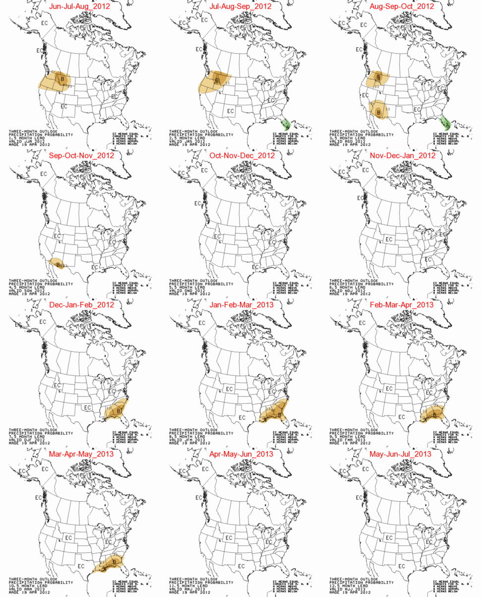
March Colorado Basin precipitation, courtesy CBRFC

March Colorado Basin precipitation

In an email last week, Kevin Werner at the Colorado Basin River Forecast Center called March 2012 “one of the warmest and driest on record in the Upper Colorado Basin.” The Forecast Center’s April 1 numbers are the ones you can start taking to the bank, with the bulk of the snow accumulation season behind us and melting and runoff now underway.

The Bureau of Reclamation has translated the runoff forecast from Kevin and his colleagues into reservoir numbers. The latest “24-month study” (pdf) shows the results. Total estimated storage combined in the reservoirs behind Hoover and Glen Canyon dams is down 1.469 million acre feet from the estimate just one month ago. Because of the equalization rules currently in place, intended to balance storage in Mead and Powell, Lake Mead is estimated to end the year with a surface elevation of 1,114.3 feet above sea level, down a bit less than 2 feet from a year ago. Powell’s estimated end-of-year surface elevation is 3,632.55 feet above sea level, down a bit more than 20 feet from last year.

Overall, total net storage in the two big reservoirs by the end of September is estimated to be 28.2 million acre feet, down 2.4 maf from the previous year. Remember that bodacious snowpack of 2010-11, all the bonus water filling both of the big lakes? 46 percent of last year’s bonus water will be gone by the end of this year, according to the new 24-month study.