At this point, a voluntary “2 to 4 million acre feet of additional conservation” Colorado River deal by Aug. 16 seems out of reach

Janet Wilson had a helpful story yesterday in the Desert Sun about California’s negotiations over its piece of the looming Colorado River cutbacks. Its bottom line is that California – the state with the largest Colorado River allocation – is talking about kicking in 500,000 acre feet of water. Or maybe it’s really just 400,000 acre feet of water – as the Metropolitan Water District of Southern California’s Bill Hasencamp told her, paraphrased, the negotiations are fluid and numbers could change.

A reminder of what Reclamation Commissioner Camille Touton told senators just seven weeks ago:

In the Colorado River Basin more conservation and demand management are needed in addition to the actions already underway. Between 2 and 4 million acre feet of additional conservation is needed just to protect critical elevations in 2023. (emphasis added)

4 million acre feet is obviously out of reach. It always was.

But if Wilson’s numbers about California’s contributions are right – and she’s a good reporter, we have every reason to believe they’re in the ballpark – 2 million acre feet of additional conservation is beyond the grasp of a voluntary deal as well.

The arithmetic is straightforward.

The Upper Basin has said “not our problem“.

Nevada’s share of the river is so tiny that its contribution is couch cushion change, a rounding error.

That leaves, in round numbers, 1.5 million acre feet of water to come out of Arizona just to get to Touton’s bottom line number for additional conservation. That would require completely drying up the Central Arizona Project canal. (CAP is taking 1.031maf this year, and averaged ~1.4maf over the previous fives years). I’m frequently surprised by Arizona, but it seems unlikely that they’ll agree to a voluntary deal that dries up the CAP canal. If that’s where we end up, Arizona’s best alternative to a negotiated agreement will be to just make the feds do it, make them take the heat. (Worth noting that FiveThirtyEight has Arizona Democrat Mark Kelly slightly favored to hold his seat. Water politics is high stakes politics.)

Combine that with the reality that Arizona’s Native American communities, major water rights holders, have complained that they’ve been cut out of this entire process, according to a July 22 letter just surfaced.

I can imagine creative accounting that might allow everyone to grin through their teeth and count water moved down to Lake Powell from Flaming Gorge and other Upper Basin reservoirs as part of the 2 million. That’s pretty clearly not what Touton called for in June. It’s not “additional conservation”. But it might create some space for a face-saving deal.

Whether that would be enough to protect us from dead pool is another question.

A reminder of the stakes

The Bureau of Reclamation’s most recent “minimum probable” model runs show Lake Powell dropping below power pool – unable to generate electricity, and forced to move water through bypass tubes that Reclamation has made clear it does not trust – by October 2023.

Under that same scenario, Lake Mead drops to elevation 992 feet above sea level over the next 24 months.

(Trust me, having to type a Lake Mead elevation level without having to use a comma made me clench.)

At that point, a lack of water will make massive cuts a self-executing reality. We’ve drained our buffer. You can’t use water that doesn’t exist.


Tribal sovereigns complain of being left out of Colorado River negotiations

In a July 22 letter, the leaders of 14 Colorado River Basin Tribal governments complained to the U.S. Department of Interior about being left out – again – of the current negotiations around short terms Colorado River cutbacks:


Click through to see the full letter.

“Drouth had no terrors here.”

In drought, we pump groundwater. Albuquerque’s Rio Grande Valley, summer 2021

I dropped off the Santa Fe Overland at Albuquerque about a year ago during the drouth that prevailed over the southwest at that time. The range was as dry and hard as a table. Rivers and streams had dried up. Cattle were dying and the country seemed utterly desolate.

Imagine my astonishment and delight when I visited this thirty-acre truck garden to find trees, flowers, grasses and the entire range of vegetables growing in the most luxurious and prolific way. It was like an oasis in the desert. Everywhere stretched the rows of beautiful green, demonstrating the resurrection power of irrigation.

Drouth had no terrors here. This grower laughed at her threats and called her bluff. Even a dried up river did not taunt him, for he simply tapped the underflow near the surface and was pumping at low cost an immense stream of water.

– Albuquerque Journal, Oct. 30, 1905, quoting an unnamed author writing in the monthly magazine “The Earth” describing their visit to Blueher’s Gardens in Albuquerque’s Old Town

I thought a lot about this passage, which my book coauthor Bob Berrens found in an old Albuquerque Journal, on my Sunday bike ride through the Albuquerque reach of the Rio Grande Valley.

While the Rio Grande itself, the part between the levees, is drying, the trend Herman Blueher and the other Old Town market gardeners started in the 1890s – using wells to keep parts of the valley floor green even as the river dries – has become a dominant way of life in the Rio Grande Valley.

Between the levees, the river in 2022 has begun drying in the Albuquerque reach for the first time in four decades, as we grind through the summer of our third consecutive terrible spring runoff. By one measure I’ve been using, this is the worst three-year stretch here since the drought of the 1950s.

It’s a complicated mix right now of hydrology and management decisions. While the river channel itself, the part between the levees, dwindles, flows of water in the irrigation ditches through town are actually up a bit. This almost certainly won’t last. The Middle Rio Grande Conservancy district has burned through the last of its imported San Juan-Chama Project water, and the only water left in storage is a bucket set aside to ensure the valley’s Native American Pueblos, with their senior water rights, can continue irrigating.

But get off the river into the communities that surround it, and you’ll barely notice the drought.

After riding out onto the Alameda bridge yesterday to gape in dark fascination at the dwindling river, my mental health management ally Scot (bike rides, amiright?) and I ducked into what I think is called the Rio Grande Estates subdivision, a little cluster of homes built in the 1980s off of Rio Grande Boulevard in the far North Valley.

Last year around this time, as the river limped, a bike ride through Rio Grande Estates was an “aha” moment for me.

On the ride: lawns, green, sprinklers spraying into the street (see picture above from that fateful day).

Home with the maps: what, what? All those homes have their own shallow wells!

When Johnson Drilling put in wells in the summer of 1988, they found a good, productive aquifer layer of gravels at about 30 feet down. The entrance to the neighborhood here is about a quarter mile from the river – the part where water usually flows on the surface. The interconnections between surface and underground water is such that the gravel layer Johnson hit is basically a part of the river – the “underflow”, as our 1905 correspondent put it.

“Drouth had no terrors here.”

What Bob and I call the “Ribbons of Green” in the new book very intentionally includes this. Our ribbons extend far beyond the boundaries of “river” set by the levees, because this is all part of the river too – the tree-lined ditchbanks, the lush lawns of these valley homes. We’ve pinned the river itself between narrow levees and then manually spread its dwindling water ourselves – with diversion dams and ditches, or with our groundwater wells – across the river’s old flood plain.

If you’re irrigating off of a ditch, this year is about to get a lot tougher. If you’ve got a well – for your lawn, or your pasture, or your farm – you’ll be OK this year. How long that can continue is an open question, very locally situational.

I’m off for the next couple of days to a state legislative committee hearing where folks will be discussing a bunch of relevant questions about what we do next:

  • How do we ensure that our indigenous communities’ rights to water are respected as supplies shrink under climate change?
  • What are the long run implications of our increasing use of groundwater to fend off “drouth”?
  • What of the environmental flows in the river itself, the part between the levees?
  • How can we protect the communities of the Middle Rio Grande Valley’s water supplies while also meeting our legal obligations to deliver water downstream?

If these questions had easy answers, we’d have already finished the quiz and handed it in to the proctor. This is hard stuff.


Does the Upper Colorado River Basin Routinely Take Shortages in Dry Years?

By John Fleck, Eric Kuhn, and Jack Schmidt

As stakeholders negotiate the current crisis on the Colorado River, we believe the representatives of the states of the Upper Basin – our states – are making a dangerous argument.

Their premise is simple. With deep cutbacks needed, the Upper Basin states argue that their part of the watershed already routinely suffers water supply shortages in dry years. Without the luxury of large reservoir storage along the rim of the watershed that might store excess runoff in wet years and supplement supplies in dry years, the argument goes, the Upper Basin is limited by the actual mountain snowpack in any given year.

This is certainly true in many places. One of us (Fleck) lives in a community (Albuquerque, New Mexico) that has routinely seen supplies of trans-basin San Juan-Chama Project water shorted because of bad hydrology in a given year.

That is also the case for the oft-cited Dolores Water Conservancy District, which has junior water rights to the supply provided by McPhee Reservoir that is part of the Bureau of Reclamation’s Dolores Project. In contrast, the adjacent Montezuma Valley Irrigation Company has pre-Colorado River Compact water rights and its access to the same water source is relatively unlimited. The argument of the Upper Basin states about using less water in dry times applies in many local settings, especially in the local context of prior appropriation water rights. The argument is certainly logical.

But when one considers the regional scale of the entire Upper Basin, the argument is not supported by the data in the Bureau of Reclamation’s Consumptive Uses and Losses reports.

Our review of those data suggests that, on average, overall Upper Basin use is slightly greater in dry years, and less in wet years. While questions have long been raised about these data, they are the best that we have and, more importantly for this discussion, they are the data that the Upper Colorado River Commission has been using in support of its argument.

Here’s what the reports show for the 21st century concerning total Upper Basin consumptive Uses less net evaporation from the CRSP Initial Units (Lake Powell, Flaming Gorge, and the Aspinall Unit):

  • in the five driest years ( 2002, 2012, 2013, 2018, 2020), the average was 4.06 MAF/year.
  • In the five wettest years (2005, 2008, 2011, 2017, 2019), the average was 4.01 MAF/year.
  • in the middle 11 years (the remainder), the average was 3.81 MAF/year.

Upper Colorado River Basin agricultural water use in wetter and drier years. Graph by Jack Schmidt, Utah State University

Importantly, a scatter plot of Upper Basin agricultural water use since 1981 shows, in general, the opposite of what is being claimed. While agricultural use varies greatly from to year, in general, use has been greater in dry years and less in wet years.

In this plot, the estimated natural flow at Lees Ferry (a good representation of whether any individual year was wet or dry) is plotted against the summed agricultural use of water by all of the Upper Basin states.  This simple analysis provides results counter to the assertion of the Upper Colorado River Commission in the sense that agricultural use of water was greater in years of low natural flow at Lees Ferry and was less in years of high natural flow at Lees Ferry. Thus, this simple relationship indicates that agriculture uses less water in wet years and more water in dry years, which is exactly the opposite of the assertion by the Upper Basin community.

Upper Colorado River Basin water use over time. Graph by Jack Schmidt, Utah State University, based on USBR Consumptive Uses and Losses Reports

Another way of looking at this question is to consider the long term temporal trend. If the Upper Basin’s argument was correct, we would see a decline in agricultural water use in the 21st century, because the river’s flow shrank during the aridification of the 21st century. However, use has not decreased.

There are important nuances in the data. In the second year of some consecutive dry years like 2012-2013, the Upper Basin’s total consumptive use drops significantly, perhaps because local storage is depleted in the first year and doesn’t fully refill in the second year. This may be the situation in 2020-2021 as well.

Why do we view the argument as dangerous? Because Lower Basin interests can do the same math we have. They almost certainly already have. That leaves the Upper Basin with a fragile foundation for entering the negotiations over the compromises that are certain to be needed to modify the Colorado River’s allocation rules in the face of climate change.

Authors:

  • John Fleck is Writer in Residence at the Utton Transboundary Resources Center, University of New Mexico School of Law
  • Eric Kuhn is retired general manager of the Colorado River Water Conservation District based in Glenwood Springs, Colorado, and spent 37 years on the Engineering Committee of the Upper Colorado River Commission
  • Jack Schmidt is Professor of Watershed Sciences and director of the Future of the Colorado River Project at Utah State University

For the first time in four decades, the Rio Grande through Albuquerque is dry

A drying Rio Grande in Albuquerque’s South Valley. July 22, 2022, photo by John Fleck

For the first time in ~40 years (? – see below) New Mexico’s Rio Grande has “broken” – is no longer flowing – in what we call “the Albuquerque reach”.

The river dries not with a bang, but with a muddy whimper and the dawn serenade of awakening birds.

Science watches a river die – the USGS gage on the Rio Grande at Central in Albuquerque

Battered by 100-degree days, with storage above us running out, the river through town has been collapsing all week. When the flow at the Central Avenue Bridge dropped to 50 cfs Wednesday, I made an after-dinner dash to look. After getting word via a friend who had been on a briefing call yesterday that drying was now “imminent”, I got up early, loaded the bike into the Subaru and drove to the South Valley.

Rivers dry from downstream up, and I’d already scouted a path in through the willow thickets behind Harrison Middle School, knowing the drying would start there. Downstream from that point, the Rio Grande gets a break – 75 cfs from Albuquerque’s wastewater treatment plant, a weird way to rejuvenate a dying stream.

My best guess based on the gages is that the “drying” happened some time yesterday. It’s a weird word, because it’s still a lovely puddly mess of mud. But there is no longer water flowing from one puddle to the next. The official word this morning is that there’s a half a mile of drying, which puts the dry stretch starting somewhere around the Rio Bravo bridge (for locals who wanna go see for themselves).

The “bosque”, as we call our riparian forest, is lovely and thick down there, and I had to walk-a-bike quite a few times to push my way through sandy, narrow old foot paths choked with willows to get to the river.

That’s part of what’s weird about this, because what I’m calling “the river” for the purposes of this post is really the surface manifestation of a much more complex hydrologic system, and a big part of the work I’m now doing for the new book bids us to think more broadly about what we mean by “river” here.

The willows and cottonwoods were green and lush. They’ve got roots that easily tap into a shallow aquifer, the “subflow” part of the river. And where the river once spread on its own across a broad flood plain, we now do the job manually with a network of ditches and drains, some of which still had water in them this morning. Along the east side, for example, while the surface manifestation of the Rio Grande itself is now dry, the Albuquerque Drain (really more irrigation main here than “drain”) is flowing today at 120 cfs.

This is a function of our community values. We created an institution a century ago to drain the swampy valley floor and manage a network of irrigation ditches where the river once flowed out on its own (read our new book! as soon as we write it!), and it is functioning as intended.

Even as the river’s surface flows dry, the ditches are drying too. Irrigators have been warned that absent rain, there will be very little to water their land very soon. South Valley horse owners (the biggest consumers of irrigated stuff around here – the horses, I mean) will be buying hay. It’s a very dry year, the agony of climate change dumped atop some water management chaos.

And for the first time in a long time, the river itself here – the part above the ground and between the levees – is going dry.

A note on how long it has been since this has happened here.

The standard line we’ve all been using is that this is “the first time the river has dried in the Albuquerque reach since 1983.”

I’ve heard that said repeatedly by my water manager friends, but I’ve not chased down how we know that.

What I do know with certainty is that drying, once far more common in this reach of the river because of the way irrigation was managed in The Old Days (divert the whole river, run the ditches full, irrigate whenever you want) has been rare since the late 1970s.

Here’s a graph of drying days at the Central Avenue gage, where we have records back to the mid-1960s:

Rio Grande drying


The poets down here don’t write nothin’ at all, they just stand back and let it all be.

Colorado has no plans to make additional cuts to water use next year to meet the Bureau of Reclamation’s demand to conserve millions of acre-feet of water, a step needed to preserve power production in Lake Powell and Lake Mead.

Instead, Colorado officials insist that other states should do the cutting.

“I think that at this point, we stand ready to hear what the Lower Basin has in mind,” said Amy Ostdiek, a section chief with the Colorado Water Conservation Board.

Source.

“You can stand on your legal theories and watch the system crash,” (Anne Castle) said. “But that doesn’t help anybody.”

Source.

“a veritable garden spot”

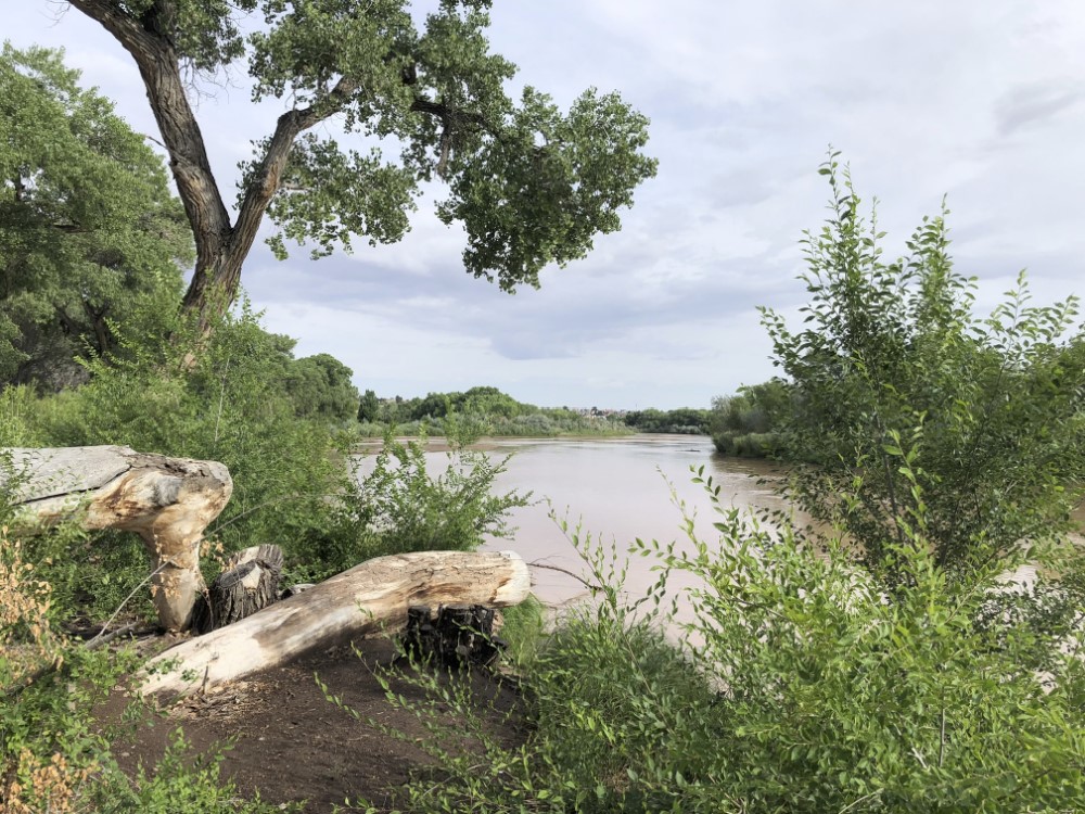
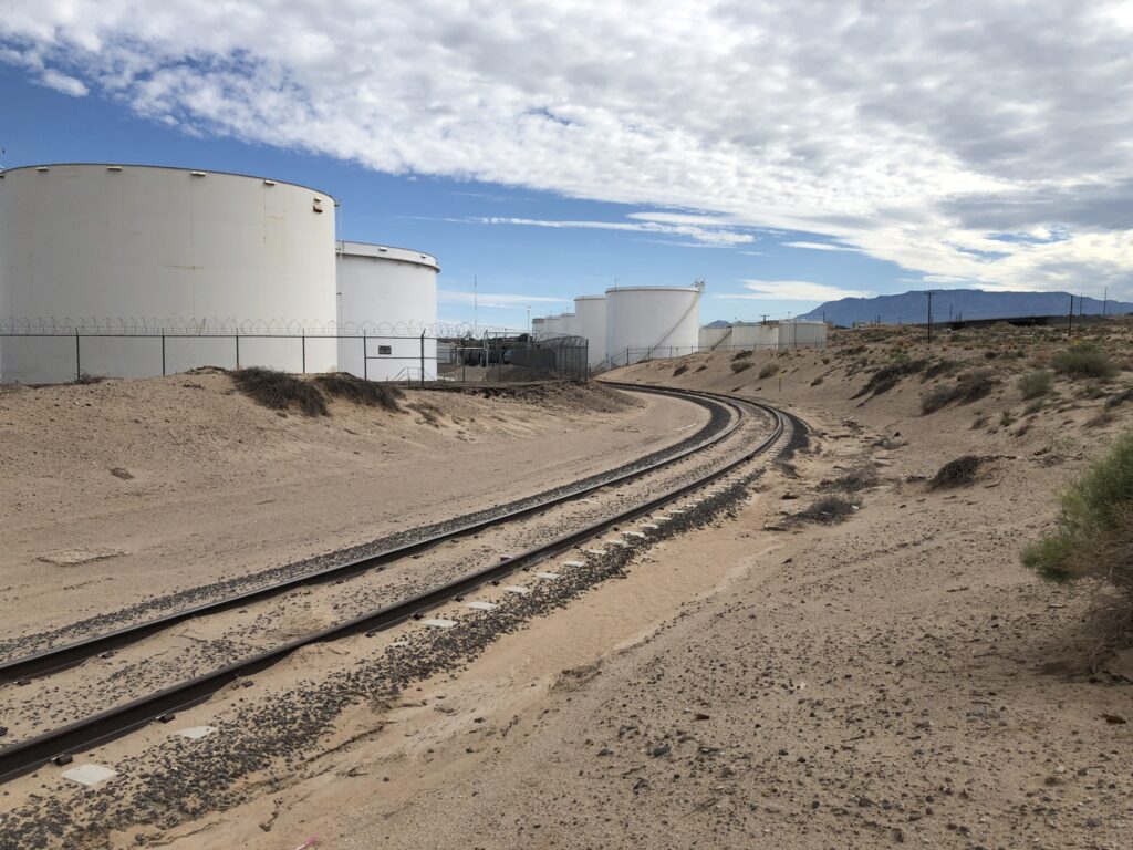
Albuquerque’s “Barr Irrigation District”, circa July 2022

Barr Irrigation District

The home of the ill-fated “Barr Irrigation District” is not one of Albuquerque’s scenic destinations.

Perched on low sand hills between Albuquerque’s soft industrial underbelly and the city’s “Sunport” (our marketing appellation for what a lesser metropolis might call an “airport”), the old irrigation district land is today home to an interstate, a power plant, a couple petroleum tank farms, junkyards, and “Fresh and Clean Portable Restrooms”.

But in 1912, when the Barr Irrigation District first glimmered in the eyes of Albuquerque boosters, it was going to “transform the central Rio Grande valley into a veritable garden spot.” A thousand acres of crops, “marketed here for home consumption and shipment” would be “the best thing for Albuquerque’s growth and prosperity” – “a rich agricultural district with this city as the center and distributing point”. (Albuquerque Journal, Jan. 13, 1912)

All that was needed was water, and H.J. Buell, an “irrigation expert” down from Denver, had the answer – “a pumping system operated by electric power”!

“Water in abundance is found at comparatively shallow depth,” the Albuquerque Journal explained in January 1912. The Journal suggested a great “free water” racket to support the enterprise: farmers could sell their rights to surface water flowing through ditches “for a substantial sum” and use the money to build more pumps and irrigate more land. (Research note: This is one of the earliest references I’ve found to sale of water rights in the valley as an economic scheme.)

As near as we can tell, a few farmers did, in fact, sign up with Buell and pump water up to the sandhills. But as the Middle Rio Grande Conservancy District made farming in the valley below more attractive by draining swampland and re-jiggering the irrigation works, the project faltered. In the ensuing years, the low sandhill area was institionally reconfigured as the ~800-ish acre “Barr Irrigation District”, the the scheme shifted from pumping groundwater to making the area an extension of the Conservancy District’s existing valley floor irrigation system, pumping ditch water instead.

Like much about the valley’s irrigation schemes, success hinged on find a source of “other people’s money” to pay for it, and when efforts at procuring federal cash failed in the 1930s, the Barr Irrigation District faded from view.

Themes from the book

Two holiday weekend diversions took me into this part of the valley south of Albuquerque – me on a Canada Day weekend bike ride with Scot, and Bob in the archives after I returned from the ride and peppered him with questions. (Having a Regents Professor with mad skills as my “research assistant” for the new book is a pretty sweet perk of the current project. Plus #GeographyByBike – Scot’s importance as a research assistant in this part of the project is crucial.)

Down the hill from the never-realized Barr Irrigation District is the Barr Canal. It’s one of those Middle Rio Grande Conservancy District ditches that has a distinctly “modern” feel – the sharp straight lines of 1920s engineering superimposed over the meanders that went before.

When I say this part of our valley might not qualify as one of Albuquerque’s scenic destinations, I say so with tongue slightly askew. It’s actually an aesthetically fascinating area, a strange mix of Charles Sheeler-esque industrial majesty, movie-set post-apocalyptic junk, and farm. My crazy GPS bike riding map games suggested this was an under-explored piece of Albuquerque, a shortcoming that, with Scot’s help, I’m working to correct.

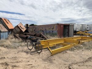
This part of the junkyard included piles of junked dumpsters. It looked like the graffiti was applied before the container’s arrival.

Scot and I this weekend rode up the Barr from the south, where it cuts through the Albuquerque Metal Recycling yards. ‘Round the back, the Barr splits the main recycling yard from its more post-apocalyptic back acres, the place where the junk yard seems to junk its junk.

It includes trashed trucks from UPS and Federal Express, and (my favorite part) an area devoted to junked dumpsters.

Mostly it was just a bike ride, but when we’re riding the valley floor, there really is no such thing as “just a bike ride”. I’m puzzling out the geography of the valley floor – why some places are homes and twisty streets, some areas were left as big farm fields, and some places got stuck with the city’s junkyards.

In his fascinating new book Tributary Voices, Paul Formisano takes on the stories we’ve been telling ourselves about the colonial watering of the west:

Striving to return to the garden once lost through the Fall, nineteenth-century beliefs about the arid West dictated man’s divine right to drastically alter the region for the onward march of progress and civilization.

Standing alongside Frederick Jackson Turner’s frontier myth, the garden myth spilled awkwardly into 20th century Albuquerque in places like the Barr Irrigation District.

I don’t know that the Barr and this stretch of Albuquerque’s southeast valley will make it into the new book Bob and I are writing (Ribbons of Green: The Rio Grande and the Making of a Modern American City, available several years from now, once we finish writing it, at a fine bookseller near you). We have too many stories already. But it illustrates a bunch of our central themes.

  • The myths of agriculture: Albuquerque and the surrounding Rio Grande Valley may never have had the dreamy agricultural past to which the boosters claimed they wanted to return, and to which the modern water policy boosters still often mythologize. But true or not, the vision shaped the city we became.
  • The role of institutions: In addition to the Barr Irrigation District, this part of the valley was home to the brief life of something called the “South Albuquerque Drainage District”. Formed in 1920, the District never seems to have gotten off the ground, and was subsumed into the Middle Rio Grande Conservancy District when it was formed in the years that followed. In developing our water management institutions, scale mattered.
  • The greening (junkyarding?) of the valley floor: The once-swampy lowlands of the valley floor were changed forever when the Conservancy District’s draglines sliced through in the 1930s, digging the low-lying ditches we call “drains” that were the district’s most important accomplishment.

The greening of the valley floor

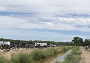
Junkyards and farms along the Barr Canal, Albuquerque, 2022

This stretch of the Barr is my new favorite Albuquerque ditchbank ride (sorry, Los Griegos!).

Up from Rossmoor Road, passage through the junkyard and into the old Schwartzman farm is weird. Smashed cars being ground up for scrap to right of us, scrapped UPS trucks to the left of us, the Barr in between running full and happy right now, and up ahead, one of the last big commercial alfalfa fields in the county being cut.

On lands that seem not to have been farmed or even settled during Albuquerque’s colonial period, the farm and the junkyard sit on land that was an old stockyard and meat processing plant run until the early 1980s by the Schwartzman family. While the sandy soil and lack of drainage may have made this part of the valley relatively less attractive than Astrisco and surrounding villages across the river, the railyards, and then drainage, made the area ideal for Albuquerque’s industrial underbelly.

The Schwartzman land has been slowly but surely carved up in recent decades, but when Scot and I left the awkward confines of the junkyards onto an open ditchbank flanked by fields, a farmer was still on the land, spending their Canada Day holiday weekend methodically cutting hay.

Verdant

Rio Grande at Albuquerque, June 20, 2022

Where peaceful Rivers soft and slow
Amid the verdant Landskip flow.

Addison

My friend Mary Harner, who loves and thinks about rivers more/better than anyone I know, is in town.

We found time this morning for a walk along our shared passion, the Rio Grande. After 78 days without rain, the monsoon bloomed on Friday, and it’s been raining since.

I sat on a downed snag poking over a muddy river as we talked. I picked idly at the moist, crumbling top layer of wood.

Moist.

Smelled good.