It is time for the federal government to further reduce Glen Canyon Dam releases

A 2022-23 forecast fraught with risk for the Colorado River Basin

By Eric Kuhn, John Fleck, and Jack Schmidt

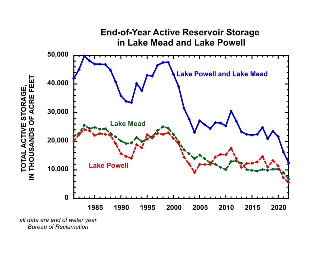
With most forecasts pointing toward another below-average winter of precipitation in the Rocky Mountains in 2022/2023 and with total basin-wide reservoir storage now less than 20 maf (less than 17 months of supply at the rate water has been consumed in the basin since 2000), it is time for the federal government to announce immediate, major reductions in Lake Powell releases for the coming water year (October 1, 2022, to September 30, 2023).

The importance of this leadership by Interior is pressing, because discussions among the basin states to cut their 2023 consumptive uses are at a stalemate and the Bureau of Reclamation is struggling to move the negotiation process along. An announcement by Interior, made no later than the 2022 Colorado River Water Users meeting in December, should set the annual release from Lake Powell for Water Year (WY) 2023 at approximately 5.5 million acre-feet (maf), 20% less than the 7.0 maf releases in water year 2022 and more than 30% less than the long-term release of 8.23 maf. Reductions in monthly releases to accomplish this objective ought to begin in January 2023.

In a news release Thursday, and in conversations at the Water Education Foundation’s Colorado River symposium this week in Santa Fe, officials with the Department of Interior and the Bureau of Reclamation suggested this option is already on the table. And Lower Basin water managers, doing the math for themselves, are already bracing for the possibility. A formal announcement, soon, would thus come as no surprise.

With last year’s decision to only release 7.0 million acre-feet in WY2022 (the water year that ends on September 30), the Secretary of the Interior has already determined that she can and will take actions to protect power generation and the structural integrity of Glen Canyon Dam. We believe it is now time to take bold action and further reduce Lake Powell releases for the following reasons:

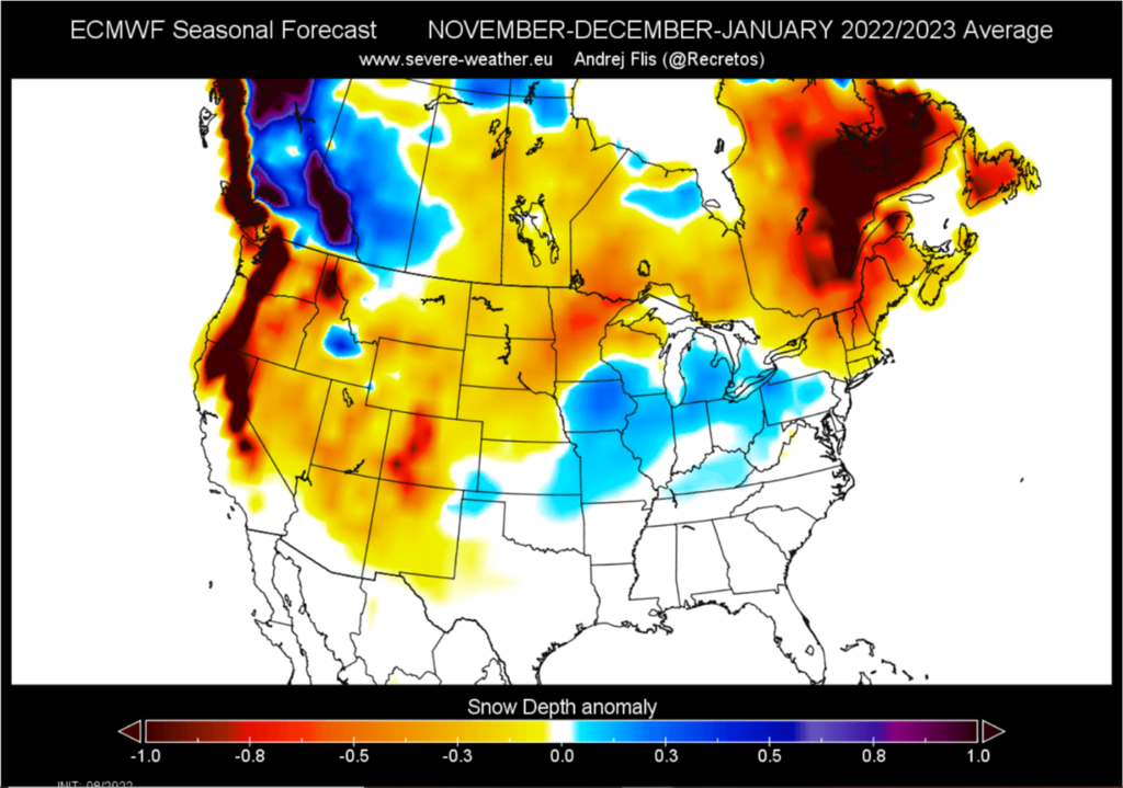
First – The winter forecast justifies an immediate reduction in releases. It is now clear that we’re headed for a La Nina three-peat at least through most of the winter. While there is still a lot of uncertainty, too many forecasts are pointing to a warm, dry winter for most of the Colorado River’s watershed, especially the Rocky Mountains. This warm and dry winter outlook means it’s time to focus on the likelihood that inflows to Powell will probably be similar to Reclamation’s present minimum probable forecast made in its 24-month study.

Second – The projections of the current 24-month study’s minimum probable forecast justify a drastic reduction in releases. Given the dry and warm winter forecasts, basing 2023 reservoir operations on the minimum probable forecast should be considered responsible water-supply management. Based on the latest projections made by Reclamation, storage in Lake Powell would drop to elevation 3469’, only ~2.7 maf of storage above the dead pool, and well below the 3490’ elevation below which hydroelectricity cannot be generated. Keeping the storage level above 3525 ft may not be possible, but an infusion of 2 maf of storage into Lake Powell through a combination of Drought Operations (DROA) deliveries from Flaming Gorge reservoir and reduced releases to Lake Mead would increase the probability of maintaining Lake Powell slightly above 3510 ft, a 20-ft (1 maf) cushion above minimum power pool elevation.  Recognizing recent cautions from Jim Prairie (the UC Region’s lead modeler) that there may only be two years of DROA releases left in Flaming Gorge, a 500,000 af delivery combined with a 1.5-maf reduction in releases from Glen Canyon Dam would be a wise strategy that would leave Reclamation with the flexibility to make one more Flaming Gorge DROA delivery in 2024, if necessary.

Third – A 5.5-maf release would create clear markers to evaluate the impacts of the additional Lower Basin cuts on storage in Lake Mead and show what is necessary to preserve power generation at both Hoover and Glen Canyon Dams. Such an action would show the urgent need for additional system cuts to preserve both Lake Mead and total system storage. A reduction in the annual release by 1.5 maf would drive Lake Mead below elevation 1000 ft, but releases of only 5.5 maf would also be likely to keep Lake Powell above minimum power pool. At the end of WY2023, Lake Mead active storage would fall to 3.7 maf (~elevation 988 ft). Assuming a resumption of 7 maf-Glen Canyon Dam releases in WY2024, Lake Mead storage would drop to elevation ~965-970 ft in July 2024, close to its minimum power elevation of 950’.  Under this scenario, both reservoirs would have only about a 20 ft cushion over minimum power pool elevation, but power generation at both dams would be preserved, albeit at a minimal level.

There are obvious tradeoffs between the reduction of Lake Powell releases to our suggested 5.5 maf and the imposition of additional reductions in Lower Basin consumptive uses. Reduction of Lake Powell releases to 6.0 million acre-feet in WY2023 would be the largest release that ought to be considered for the coming year, because such a release would only increase storage about 20 ft. Reducing releases to 5.5 maf or even 5 maf would be much wiser, but even these radical policies may only be enough to “tread water.” Recovering system storage is likely to take several more years of reduced releases from Lake Powell that might include additional years when annual releases are as low as 5 maf.

Fourth – If the forecast of a dry winter proves to be in error and more precipitation comes in late winter 2023, Reclamation can increase the annual release during the spring.  Reclamation has the flexibility to increase annual releases back to 7.0 maf/year (or more under the possible, but unlikely, event of a big year).  Ideally, if the Lower Basin has a plan in place to cut an additional 1.5-2.0 maf of its uses, the benefits of such an increase in Powell releases later in the water year could also be redirected to recovering storage in Lake Mead.

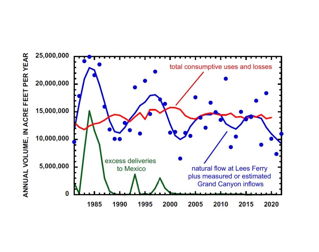
Fifth – A 5.5-maf release in WY2023 could leave the Upper Basin with a future compact deficit that would force resolution of the long-standing dispute over the Upper Basin’s 1944 Treaty obligation to Mexico. The ten-year flow at Lee Ferry for 2013-2022 will be about 85.5 maf, but under our proposed scenario of a 5.5 maf release in WY2023 and a continuation of the Millennium Drought, the ten-year total release would be less than 82.5 maf by 2025 or 2026. Further, as the 9-maf years from 2015-19 fade into the past, the running ten-year tally could stay well below 82.5 maf through the end of the decade.

Denver Water CEO Jim Lochhead has labeled this 82.5 maf metric as the basin’s first hydrologic “compact tripwire.” This observation is based on the Lower Division States’ view that under the 1922 Compact, the Upper Division States have an annual obligation to contribute 50% of the 1944 Treaty delivery to Mexico every year (normally 750,000 af, but a little less when Mexico takes a shortage) plus the 75 maf non-depletion obligation. The Upper Division States, of course, disagree, taking the position that the 750,000 af release for Mexico is a “luxury”, not a requirement under the 1922 Compact. Their view is that their Lee Ferry obligation is no more than 75 maf every ten years.

The Upper Division States’ position, however, puts their post-Compact uses at considerable risk!  If the basins are unable to reach a compromise and turn to litigation instead and the Supreme Court rules in favor of Arizona, Nevada, and California or even finds a middle ground, it’s quite likely that the Upper Division States could end up owing a lot of water or money or both. The Upper Division states would be wise to consider resolving their Mexican Treaty obligation as a part of the post-2026 guidelines negotiations.  Having an effective Upper Basin demand management program (or functional alternative) in place will almost certainly be a part of any negotiated settlement.

Summary If the WY 2023 runoff turns out to be below average, as many forecasts now suggest, maintaining Lake Powell storage elevation above minimum power pool with a reasonable cushion will require a combination of (1) another DROA release from Flaming Gorge Reservoir and (2) a significant reduction of the WY 2023 Lake Powell release to well below 7 maf. At this point, using the most probable 24-month forecast which uses an optimistically wet (1991-2020) hydrologic baseline and totally ignores the available winter forecasts, simply obfuscates reality, and creates obstacles to finding the needed cuts. Using the minimum probable forecast to set the 2023 annual release sooner than later would add both clarity and urgency to the stalled task at hand – finding the necessary additional cuts needed to stabilize and recover the system. Using the minimum probable forecast is a “no regrets approach.”  If the forecast improves, an upward adjustment of annual releases is an easy and welcome fix. The opposite, a downward adjustment made in spring 2023, would create more havoc.

There are associated issues that Reclamation ought to begin to consider immediately.  What would be the impact to the Grand Canyon ecosystem of a 5.5-maf annual release?  How should monthly flows be distributed under such a low annual release? How should the present invasion of smallmouth bass in Grand Canyon be managed under very low annual releases? What might be the impact on commercial river running in Grand Canyon in 2023? How should the ever-increasing temperatures of Powell releases be managed?  These are all questions that need to be addressed in fall 2022 so that our recommendations can be implemented in January 2023.

We’ve suggested the 5.5 maf figure based on the September 24-month study. By November or December, the minimum probable forecast may dictate a different release number.

Whatever that number is, Reclamation should consider letting the basin know as soon as reasonably possible.

  • Jack Schmidt is Janet Quinney Lawson Chair in Colorado River Studies, Center for Colorado River Studies, Watershed Sciences Department, Utah State University
  • John Fleck is Writer in Residence at the Utton Transboundary Resources Center, University of New Mexico School of Law; Professor of Practice in Water Policy and Governance in UNM’s Department of Economics; and former director of UNM’s Water Resources Program.
  • Eric Kuhn is retired general manager of the Colorado River Water Conservation District based in Glenwood Springs, Colorado, and spent 37 years on the Engineering Committee of the Upper Colorado River Commission. Kuhn is the co-author, with Fleck, of the book Science Be Dammed: How Ignoring Inconvenient Science Drained the Colorado River.


Collective Action and the Ribbons of Green

A paragraph from the new book Bob Berrens and I are writing about the Rio Grande and the making of modern Albuquerque:

To understand a community – any community – you can start with its water. Collective problem-solving, collective action, lies at the core of community, and our relationship with our water requires us to come together. Our communities grow up around water – bays around which to fish, harbors for our boats, rivers from which to drink, bathe, and irrigate our crops. The problems posed by those ways of life quickly become collective: How do we share the costs and benefits of diverting water to irrigate lands? How do we ensure the drainage from our irrigation doesn’t leave those living adjacent to the river downstream in a pestilent swamp?

Castle appointed federal rep on Upper Colorado River Commission

The White House announced today it has appointed Anne Castle as the federal representative on the Upper Colorado River Commission.

Anne is former Assistant Secretary of Interior For Water and Science, where she helped steer the federal boat through chaotic Colorado River rapids. She’ll be an important asset now that the rapids seem that much worse.


A reminder that the federal government does not use Colorado River water

Count me among those in the Colorado River community who was disappointed last month with the lack of Department of Interior action on its threats should the states not come up with a plan to sufficiently reduce their water use.

But let’s remember the core issue here: the states of the basin, especially the Lower Basin, and especially California and Arizona, are using too much Colorado River water.

The very fact that we’re having this conversation about a need for federal action is a direct result of the fact that California and Arizona have been unwilling to act to save themselves.

As I’ve written before, I believe in the importance of federal threats in spurring Colorado River progress. But let’s remember why they’re needed.

They’re needed because the water users have been unwilling to save themselves from the increasingly frightening results of their own excesses.

Keys to Past Colorado River progress

As we watch the quivering uncertainty about the nature of the federal threat on the Colorado river, it is perhaps worth a look at past moments of progress in Colorado River governance, and also past roadblocks.

Anne Castle and I ran this stuff down for a paper we published last fall.

Some history shows a pattern – low river flows, combined with a federal threat.

2002-03 California Quantification Settlement Agreement

Low flows

The initial trigger came at the height of the 2002 drought, the worst inflow year in recorded history.

Federal threat

At a meeting of the Colorado River Water Users Association in mid-December 2002, Secretary of the Interior Gale Norton warned that California’s deliveries would be reduced unilaterally by the Interior unless QSA was executed by the end of the year. In fact, however, the Lower Basin states were not able to reach an agreement by the deadline, and surplus water that had previously been available to California water users was cut off. Deliveries to California water users were abruptly limited to 4.4 million acre feet (5.4 bcm) in 2003, a reduction of approximately 800,000 acre feet (1 bcm) from previous levels. Importantly for the future of water agreements in the basin, despite predictions of doom, California absorbed the reductions with only modest impact.

2007 Interim Guidelines

Low flows, federal threat

However, the drought persisted and again, in 2004, Interior officials warned that cutbacks in deliveries would be imposed unless the Basin States agreed to a drought management plan on their own. In 2005, the Secretary of the Interior directed Reclamation to develop additional Colorado River management strategies to address operations of Lake Powell and Lake Mead under low reservoir conditions. After much discussion, haggling, and evaluation of alternatives, the Colorado River Interim Guidelines for Lower Basin Shortages and the Coordinated Operations for Lake Powell and Lake Mead (Interim Guidelines) were adopted in 2007.

Drought Contingency Plan

Low flows

Continuation of low flows in the river system in the second decade of the 21st century resulted in the realization that the accommodations made in the 2007 Guidelines and agreements with Mexico were insufficient to balance supply with demand.

Federal threat

In 2013, Secretary of the Interior Sally Jewell urged the states to take immediate action and come up with a contingency plan to address the potential for lower flows caused by climate change [70]. Referencing her predecessors, she said that she would not ignore her responsibility “to act if conditions worsen and if the states can’t reach consensus on contingency actions

More low flows (and inaction)

However, by the end of 2018, while many component parts of the plan had consensus, there was still no final deal. The remaining hurdles were not disagreements about the basic components but rather the intrastate allocation of reduced supplies and desired commitments for environmental restoration efforts.
During 2018, Lake Powell dropped significantly, but the water levels in Lake Mead remained relatively stable water leaders in Arizona—the key holdout in approving the deal—saw fewer reasons for quick action
Another federal threat
The Commissioner of Reclamation Brenda Burman then warned that if the plans were not completed by 31 January 2019, the Department of the Interior would adopt a course of action prior to the following August.
There seems to have been a pattern.

Visiting the Birds

The Birds, by Irot

Saw the Birds above from the train window yesterday, and went back today on my new ebike for a closer look.

The ebike is primarily an accommodation for my age and failing knee, allowing me to ride more longer when I feel like it – hauling groceries, or books and laptops to work, or searching out distant tacos, that sort of thing. But with its motor and giant everything-proof tires, it also proved a useful workhorse this morning for getting up the railroad tracks in Albuquerque’s near North Valley for a closer look at Irot’s Birds.

Next Steps on the Colorado River

If we have learned anything from the current crisis on the Colorado River, it is that we have to know what we’ll do next if the current thing we’re doing isn’t enough.

That’s a bloggy shorthand for a deep argument that Eric Kuhn, Jack Schmidt, and I made in comments we submitted this week in response to the U.S. Department of Interior’s request for input on the development of new river operating guidelines.

As we begin discussing what replaces the soon-to-expire Colorado River operating guidelines, we argue that there are important lessons to be learned from a careful examination of the way the current guidelines have failed us.

The Failure of the 2007 Guidelines and Drought Contingency Plan(s)

In its Final Environmental Impact Statement in support of the 2007 Interim Guidelines, Interior identified the purpose and need of these Guidelines as an effort to provide “predictability” – “a greater degree of certainty to United States’ Colorado River water users and managers …, thereby allowing water users … to know when, and by how much, water deliveries will be reduced in drought and other low reservoir conditions.”

“Predictability”? “Certainty”? Crisis of 2022 says “nope”.

We’re trying to use language here – “purpose and need”, the National Environmental Policy Act terms of art – that burrows into the heads of the hard-working feds who will be reading it (we wave – you know who you are).

The failure, which Eric, Jack, and I talked about here in an argument developed while we were working on these comments, was a set of operating rules keyed on reservoir elevations in a way that managed to hold them steady, but never refilled them. That left us vulnerable to the crash that we’re now seeing.

Our immodest suggestion

New operating rules must be keyed to the actual flows of the river, not simply the levels of the reservoirs:  “[S]tream flow should be used as a component in triggering different operating regimes, not solely reservoir elevation levels.” This was the great failing of the ’07 guidelines. We need to fix it.

In some sense this seems obvious, because hydrology is now imposing this constraint on us – “long-term average consumptive uses and losses will not exceed the average natural water supply provided by the watershed”.

We recognize that there are multiple devils in the details of this recommendation including the duration of years during which balance is sought and the mechanisms by which reductions in use must be implemented to maintain a balance. Nevertheless, there is no alternative to balancing the system. We estimate that the natural supply for the period 2000-2022, including inflows within Grand Canyon, has been 12.8 maf/yr, and there is no alternative but to at least reduce basinwide water use to that value. Should watershed runoff decline even further, then basin-wide use must be further reduced.

And if or when it gets wetter again?

[I]f relatively wetter periods return, consumptive uses must remain low to recover reservoir storage.

And all of this must be done in a way that recognizes who’s been left out of past discussions like this:

We are fully cognizant of the conflict between full development of currently unused or unquantified Tribal water rights and the need to reduce overall water uses in the Basin. We believe, however, that an appropriate balance of water supplies and uses cannot ignore the unquestioned right of Tribal nations to the water necessary to fulfill the purposes of their reservations.

And this (we wave again – you know who you are):

We recognize that these goals are broad, extending beyond what some in the basin are advocating – a narrow reconsideration of reservoir operations. We are sympathetic to the burden that the breadth of analysis we are advocating will place on the dedicated and hard-working staff at Reclamation and the Department of the Interior during the next years. But anything less than an expansive view of the task at hand will fall far short of what is needed at this moment in history.

There’s lots more in the way of specifics. We encourage those interested in river management to give it a look.

Welcome new readers!

Agricultural heritage?

Welcome new readers!

With the current attention on the Colorado River’s crisis, I’ve had a great many people sign up for my blog feed in recent weeks. I’m so happy to have you join our Inkstain community! But an up front apology may be in order, as this might not be what you expected.

I’m John Fleck, a former journalist turned academic. I spent five years as director of the University of New Mexico Water Resources program, and I’ve recently joined the Utton Center, a natural resources policy group at the University of New Mexico School of Law, as the center’s Writer in Residence.

I’ve written a couple of books about the Colorado River, and at times I use this blog to perform a sort of “post-journalism”, sharing important stuff that I have learned. After 35+ years of daily journalism, it’s a hard habit to break.

I also have active collaborations with a group of friends and colleagues, and the blog is a great place to throw our stuff out into the information sphere when we think it might be of some use.

Ribbons of Green

I had every intention of putting my Colorado River work on simmer in 2022 – still available for snacking, but not the main meal. With my friend and colleague Bob Berrens, I’m hard at work on a new book about Albuquerque and the Rio Grande, a sort of environmental/institutional/literary work on how our community’s relationship with the river shaped both.

We’ve actually signed a contract. We have an actual deadline for the book.

Albuquerque Journal, Oct. 8, 1882

Bob and I teach graduate students in the University of New Mexico’s Water Resources Program and share tidbits like the old newspaper clip to the right, an 1882 real estate advertisement in which a chap named D.B. Emmert (“notary public, real estate and insurance broker”) is selling what seem to be the first explicitly advertised parcels of irrigated suburban land: “Splendid opportunities … for those who want vegetable or fruit gardens or suburban houses”).

The railroad had just arrived in Albuquerque, a moment of profound change that has delightfully weird water policy implications.

We’re fascinated by the cultural evolution of the valley in which we live, as we alternately battled with, and embraced, the Rio Grande, the river that flows through the midst of our town. As a matter of rhetoric and cultural identity, our community celebrates its “agricultural heritage”, but we’ve created more than a century’s distance between those hazy, romantic notions of that heritage and its reality – then and now.

That distance, and those notions, have critical implications for water policy today, which is what dragged Bob and I into this arena. “There’s less water. What do we do?” is the framing question for our students’ journey through the eclectic fall class about to get underway. For the tenth time! This is the tenth fall we’ve taught this class together!

Bodies in Lake Mead

Turns out Casablanca isn’t actually a desert! (I was misinformed.)

Unfortunately for my best-laid plans for 2022 (also, more importantly, for the 40 million people who depend on the Colorado River – my problems don’t amount to a hill of beans here), they’re finding dead bodies in Lake Mead. Because there’s not very much water in it. Which means less water for the people downstream who depend on it, or the people upstream who may or may not bear some responsibility for helping refill it.

This has captured a bit more of my attention this year than I had hoped, which is likely why, dear new readers, many of you have joined our little community. I’m a writer. I can’t help but write about what I’m thinking about. And I’m thinking about the Colorado River.

Sketchbook

This blog has always been my sketchbook – a habit I acquired from my late father, who was an active, productive artist his entire life. His sketchbooks were everpresent in our lives. The twist for me is that, as a lifelong newspaperman, I only know how to write in public. Journaling, diaries, have never worked for me. So when blogging emerged in Internet 1.0 days, I took to it.

I have no editor. There will be typos.

It is my fervent hope, dear new readers, that you’ll read a lot here in coming months about the gardens of early Albuquerque – the crazy early 20th century lawn irrigation patents and swamps-turned-tobacco farms-turned-boutique alfalfa stands.

It is my clear-eyed expectation that you’ll see a lot of my agonized musings about the dark, dead-bodies-in-Lake Mead trajectory of my beloved Colorado River.

It is my promise that, broken-down knee notwithstanding, you’ll still get a healthy dose of bike riding essays. (I just invested in an e-bike! My bad knee celebrates!)

Welcome!


Nevada: lack of a deal threatens the future of the Colorado River

Strongly worded letter today from John Entsminger of the Southern Nevada Water Authority about the failure to reach a deal on Colorado River cutbacks:


More later, I’m supposed to be paying attention to a zoom meeting, but making this as broadly publicly available as possible seemed important. Click the “view document” link to see the whole thing.

How We Got Into This Mess on the Colorado River

By Jack Schmidt, John Fleck, and Eric Kuhn

On the eve of the release of the US Bureau of Reclamation’s August Colorado River reservoir forecasts – freighted with meaning this month because of Reclamation’s ultimatum to the states about the need to cut water use – we look back at the last four decades of water-supply management to pose the central question:

How did we get into this mess? Our answer in brief:

When the Colorado’s flow was up, we used it all.

When it was down, we drained the reservoirs.

The river’s natural flows have been down for a long time.

And during the few stretches of somewhat higher flows, we did not significantly refill the reservoirs.


A failure to set water aside for the future

Colorado River water use outpacing supply. Graph by Jack Schmidt, Utah State University

Operating year to year, it is easy to get lost in the river’s annual ups and downs, and the immediate desire to get water to farm fields and cities – THIS YEAR! NOW!

But the longer view, based on the best available data, makes clear our mistakes during the past 20 years. Since the year 2000, the blue line in the graph above has spent little or no time above the red line. That is water use outpacing supply.

The result – the most recent three consecutive dry years have left us with headline-clear problems:

  • Reservoir storage is 66 percent less than it was in 2000.
  • Reclamation is concerned about the structural integrity of the river outlets at Glen Canyon Dam that will be continuously needed if Lake Powell falls below the minimum power pool elevation.
  • Las Vegas’s old water supply intakes – and dead bodies! – are emerging from the Lake Mead mud.

21st century Colorado River water use has exceeded supply by 1.2 million acre feet per year

The graph’s nuances are worth noting.

Blue dots represent each year’s total natural water supply – the sum of the natural water yield of the entire Upper Basin and of the many springs and tributaries that flow into the Colorado River in the Grand Canyon. This natural supply, not considering the Gila, Bill Williams, or Virgin Rivers, averaged 12.8 maf/yr (million acre feet per year) in the 21st century, 23% less than the average between 1981 and 1999.

To help visualize longer-term trends and cycles, we statistically smoothed the data to create the blue line, which more clearly shows the longer-term ups and downs of the Colorado River’s flow. The smooth line makes clear the wet periods of the 1980s and 1990s, and the deep droughts of the early 2000s and of today. Importantly for our current mess – the “wets” of the 21st century were not as wet, and the “drys” were drier, than those of the late 20th century.

The red line – total basin water use and reservoir evaporation loss (not including uses and losses in the Gila, Bill Williams, Virgin, or Little Colorado watersheds)  – crept up through 2000 as the Central Arizona Project finally grew into the paper water allocations of the 20th century Law of the River.

Total consumptive uses and losses, including treaty deliveries to Mexico, peaked in 2000 at ~15.8 maf and were reduced during the next 2 years. Thereafter, average basin-wide consumptive uses and losses remained ~14.2 maf/yr between 2003 and 2020, and individual years were consistently within 4% of the average of that period. Throughout the 21st century, total Upper Basin uses and losses were ~30% of the basin-wide total.

Sustained consumptive uses and losses that exceed the natural supply can only be sustained by draining the reservoirs – but only so long as there is available water in the reservoirs. Thus, it is no surprise that the 21-year average (2000-2020) rate of water consumption and losses that exceeded the natural supply by ~1.2 maf/yr led to today’s crisis.

There were a few opportunities to rebuild reservoir storage, especially in 2005, 2008, 2009, 2011, 2017, and 2019, but a decades’ long water consumption rate that exceeds natural supply is unsustainable. The reservoirs are now mostly drained.

The failure to refill

The reservoirs’ decline. Graph by Jack Schmidt, Utah State University

The history of water storage, described in the two graphs, has gone like this:

  • The reservoirs were brim full in the mid-1980s and lots of water passed through the delta to the Gulf of California
  • Reservoirs were somewhat depleted in the late 1980s and early 1990s when basin-wide consumption exceeded natural supply, but the reservoirs refilled in the late 1990s due to three years when supply greatly exceeded consumption (1993, 1995, and 1997). Thus, the reservoirs were relatively full in 2000 when the Millennium Drought began.
  • Reservoir storage greatly decreased thereafter when the natural supply was never greater than 11.7 maf/yr (2001) and was as low as 6.39 maf/yr (2002).
  • Reservoir storage stabilized at a new lower level thereafter when there were a few wetter years between 2006 and 2011. The last relatively wet year was 2019, but our continued use of large quantities of water was such that this sequence of somewhat wetter years was not used to rebuild reservoir storage.
  • Natural supply has been especially low between 2020 to 2022, averaging 9.4 maf/yr, which is far less than the basin-wide consumptive uses and losses that are approximately 14 maf/yr (we note that basin-wide consumptive use data are not available for 2021.)

Thus, today’s crisis – two decades of low natural supply, including some short, very dry periods, cannot sustain consumption and losses that exceed the natural supply and that have not significantly changed since 2003.

Policy Implications

What are the policy implications of this analysis?

  • There has been a natural cyclicity of somewhat wetter and somewhat drier years, but the recent wet periods, when the reservoirs might have been refilled, have not been as wet as in the 1980s and 1990s.
  • The recent dry period that we are experiencing today since 2020 is comparable to the dry period of 2000-2005.
  • Reductions in consumptive water use and losses mandated by Commissioner Touton will need to remain in place through the end of the present very dry cycle and well into any future wetter cycle in order to rebuild reservoir storage.
  • The call for an immediate reduction of 2-4 maf/yr in consumptive uses and losses is an unprecedented reduction in relation to the pattern of use in the watershed since 2003.
  • Anything less than sustained reductions of the scale demanded by Touton’s ultimatum risks crashing the system – certainly if we get another year or two of very low runoff from the Rocky Mountains.

An explanation of our methodology

The present water-supply crisis is a simple mass balance problem and we sought to describe this mass balance in the simplest way – averaging for the entire watershed

How did we consider inflows?

  • We used Reclamation’s estimates of natural flow at Lees Ferry, including the provisional data that are available for 2022. We used ~40 years of data.
  • We estimated inflows downstream from Lees Ferry that flow into Lake Mead based on the difference between USGS measurements made at Lees Ferry at the upstream end of the Grand Canyon and near Peach Springs, just upstream from Diamond Creek at the downstream end of the Grand Canyon. These data are available for 1990-2021, and we used the average for the 1990s as the estimated inflows of the 1980s. We used the average for the 2010s as the inflow in 2022. These data include inflows from the Paria and Little Colorado Rivers.
  • We added these two data sets as the available natural supply available for water users. We did not consider the natural inflow of the Virgin, Bill Williams, or Gila River because these rivers, with only rare exceptions like year 2005, are fully depleted and considered the sole domain for use by the Lower Basin states. Note that 2001-2005, Lower Basin use of these three tributaries was 2.2 maf/yr (the last years for which these data are available).

How did we estimate consumptive uses and losses?

  • We used Reclamation’s Consumptive Uses and Losses reports and Water Accounting reports
    • For the Upper Basin, we used revised and peer reviewed data prior to 1995 and provisional data 1996 to 2020. Data for 2021 are not available.
    • For the Lower Basin, we used Colorado River system summaries prior to 2005.
    • For the Lower Basin, we used Water Accounting reports 2006-2021.
    • We assumed that Lower Basin mainstem reservoir evaporation 2006-present was same as the average for 2001-2005 (1.1 maf/yr).
    • We only considered Treaty deliveries to Mexico as a use, and large surplus flows of the 1980s and 1990s were assumed to have passed to the sea.

We assumed that the uncertainty of all values was 2 or 3 significant digits and rounded off our calculations accordingly.

the authors

  • Jack Schmidt is Janet Quinney Lawson Chair in Colorado River Studies, Center for Colorado River Studies, Watershed Sciences Department, Utah State University
  • John Fleck is Writer in Residence at the Utton Transboundary Resources Center, University of New Mexico School of Law; Professor of Practice in Water Policy and Governance in UNM’s Department of Economics; and former director of UNM’s Water Resources Program.
  • Eric Kuhn is retired general manager of the Colorado River Water Conservation District based in Glenwood Springs, Colorado, and spent 37 years on the Engineering Committee of the Upper Colorado River Commission. Kuhn is the co-author, with Fleck, of the book Science Be Dammed: How Ignoring Inconvenient Science Drained the Colorado River.