Clouds over the neighbors’ house, June 2014

Clouds over the neighbors’ house, June 2014

Capital, by Thomas Piketty, at Costco
Berkeley agricultural economist E. Phillip Leveen seems to have been* the person who coined the term “iron triangle” to describe the political structure behind large scale 20th century water development in the western United Staes. The “triangle” is an attempt to describe the relationship between federal water agencies, members of key congressional committees responsible for allocating tax money for the great water works, and water users – generally agricultural water users. Here’s Leveen describing the U.S. Bueau of Reclamation in 1972:
The Bureau must find political support for its program to be successful. Congress provides the funds for the program, but only in response to political pressures from constituents. Thus, the Bureau must form an alliance with a powerful political constituency which can “demand” its product from Congress. The most effective political groups are generally small, cohesive producer groups rather than large, amorphous constituencies. These latter groups, even if given benefits equivalent to the small group, are less likely to organize politically because the costs of organizing large groups are higher and the benefits per individual are lower in comparison to the small group. According to this model, then, the Bureau’s support of the large landowners was dictated largely by the need to form an effective constituency.
Over most of the 20th century, that seems to have been a reasonable model for how things worked. But has it broken down?
Consider my story from this morning’s newspaper, about new water legislation from Sen. Tom Udall, D-N.M., aimed at drought and water management targets, primarily on the Rio Grande:
Saying the days of big water projects and large federal investment are over, Udall said in an interview Wednesday that the legislation looks instead at the full range of the federal government’s water operations in the state, and ways current laws could be tweaked and additional financial support provided to stretch the state’s limited supplies.
It is not a criticism when I characterize this bill as “small ball”, a series of legal tweaks and relatively small financial incentives aimed at the narrow piece of New Mexico water management that involves federal control and/or room for discretionary action. It rather, I think, describes a new state of affairs that seems to look nothing like an “iron triangle”, where the opportunities and constraints have changed and we’re still sorting out what a new role for the federal government, and a new political structure, might look like in a time of scarcity.
* Leveen’s 1972 piece is the earliest use of the phrase “iron triangle” to describe western water management that I’ve been able to find. (I’d love any earlier references.) Leveen, in a footnote, attributes the underlying concept to Theodore Lowi’s 1969 book The End of Liberalism. In it, Lowi describes a “triangle” in federal agricultural policy and politics through several examples, including the Extension Service and the Soil Conservation Service. Lowi doesn’t specifically mention water agencies.
Last night, I shared Part I of an interesting discussion by Arizona water managers of the risk facing Lake Mead and Lower Colorado River Basin water users in Nevada, Arizona and California:
Absent some big wet years or management intervention, Lake Mead could drop to levels in the next five to eight years that would make it nearly unusable – especially for power generation and water for Las Vegas, but also at some risk for other downstream users.
The evaluation by the Central Arizona Project water managers is pretty grim. But Part II, in the morning light, may be more interesting. It’s the boldest proposal I’ve seen in public from inside the water management community for fixing the lower basin’s “structural deficit” – the fact that routine Colorado River water use in the three states is greater than the river can supply.
It’s a “share the pain” proposal, and calls for taking steps ahead of the problem to slow Lake Mead’s decline “based on principal that all Colorado River water and power users share risk”.
It would:
So maybe I was too gloomy blogging into the late hours last night? Does the “Drought Response and Sustainability Plan” now in the works offer the chance to get ahead of the problem?
Here’s the full CAP slide deck. The stuff about the solution space begins on page 32:
From the morning newspaper, a column about the assumption embedded in Albuquerque’s water utility budget – that Albuquerque water conservation has hit bottom:
[T]he Albuquerque Bernalillo County Water Utility Authority’s latest spending plan bets you’ve finally hit the conservation wall, projecting that from the current 134 gallons per person per day, you’ll go up to 135 next year. That’s an extra 250 million gallons over the course of the year.
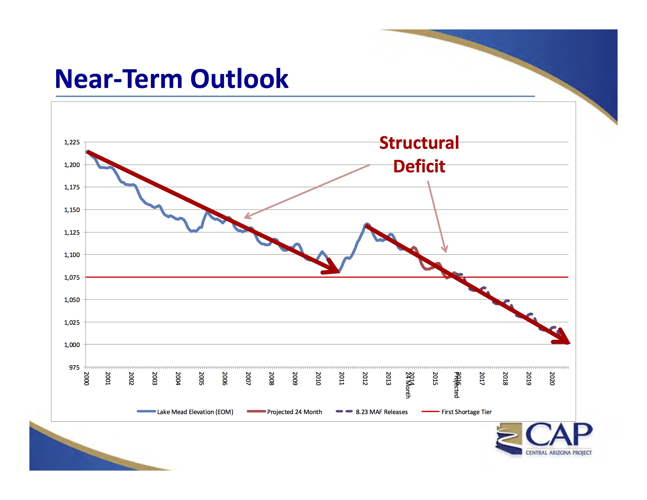
Near Term Lake Mead Outlook, courtesy CAP
update: see also Part II, discussing Arizona’s suggestion regarding what it might take to fix this problem
Absent some big wet years or management intervention, Lake Mead could drop to levels in the next five to eight years that would make it nearly unusable – especially for power generation and water for Las Vegas, but also at some risk for other downstream users – according to a presentation last week by staff at the Central Arizona Project to the agency’s board of directors.
That five-to-eight year time frame is how long it might take, under the scenario sketched by CAP staff, for the surface elevation of Lake Mead to drop to 1,000 feet above sea level – like Four Minutes to Midnight on the Colorado River Doomsday Clock or something. It’s still not midnight, but scary close.
The problem is not drought, though drought makes it harder to dig out of the hole now being created. Rather, it is a “structural deficit,” according to the presentation by the CAP’s Tom McCann and Chuck Collum. The Lower Colorado River Basin’s full legally required allotment each year from the Upper Basin – 8.23 million acre feet – is not enough to meet all the Lower Basin’s water needs. Only with periodic infusions of what I’ve been calling “bonus water” – extra water during unusually wet years – can the Lower Basin make ends meet.
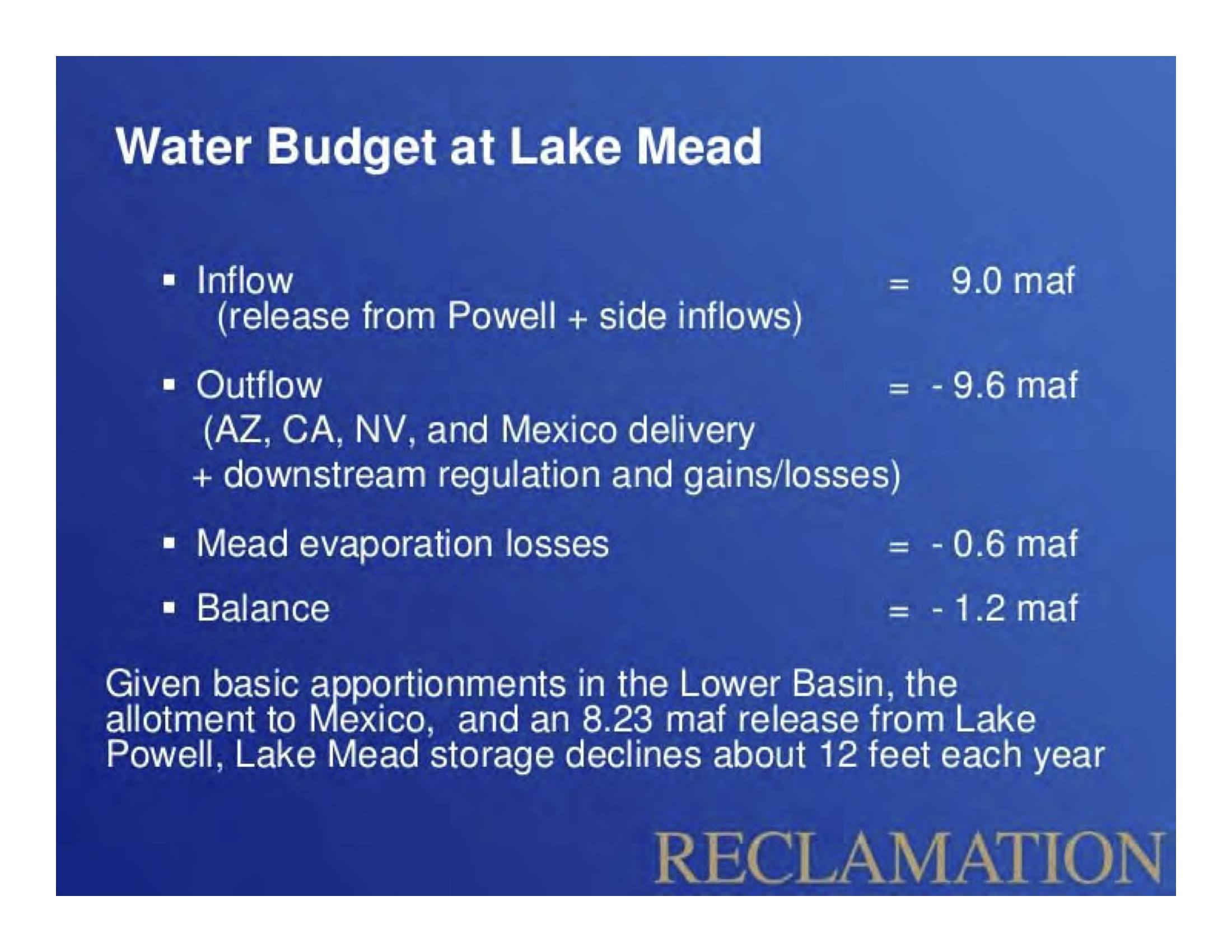
Lower Basin Water Budget, courtesy USBR
The basic deficit spending math is not new. (See for example Why is Lake Mead Dropping from four years ago or my personal favorite, Hookers and Blow on the Lower Colorado.) What’s new is to hear the analysis of the problem and its dire implications come in the form of a stark public warning from the staff one of the most important water-using agencies in the Lower Basin. This is not some snarky blogger talking. This is coming from the number crunchers at CAP.
I first saw the key math involved in the Lower Basin water budget at a reservoir management meeting in Las Vegas back in the spring of 2010, but the numbers have been around for longer than that. It was a talk by Paul Miller, who then worked for the USBR, and he used exactly the same slide as the one to the left – the slide used in the CAP presentation last week. The math is really simple – a full delivery into Lake Mead is about 9 million acre feet, while evaporation is 0.6 million acre feet and downstream requirements are 9.6 million acre feet.
That’s a 1.2 million acre foot “structural deficit” that’s only made up for when there’s extra water above and beyond the Colorado River Compact’s required deliveries.
That graph at the top shows Lake Mead dropping in 12 out of the last 15 years despite the fact that the big reservoir has gotten its full allotment every single year. That’s the structural deficit.
So what happens if nothing is done and Mead hits 1,000 feet above sea level? A couple of the impacts are the results of physical constraints on the system.
Beyond that, if nature (in the form of unusually wet years) or the federal government (in the form of intervention to conserve before Mead hits the breaking point) doesn’t intervene, the CAP analysis suggests we’ll be left with what water managers call “run of the river” operations – the only water available each year is the water nature provides. Hoover Dam could be used to smooth out the timing a bit, holding during high flow times of year to deliver water during low flow times of year. But in terms of year-to-year storage, it would be almost like we don’t have a dam at all.
Here’s the full CAP slide deck:

Hay bales at Valle do Oro in Bernalillo County’s south valley, June 2014
In 2012 cattle, calves and dairy made up 78.6 percent of New Mexico’s farm receipts. Hay to feed them was the next-largest component of the state’s ag economy at 4.3 percent. Pecans were next at 2.7 percent, and our famous chile made up 1.6 percent of farm receipts.
Source: USDA ERS
In the background, you also can see some cottonwoods.
It seems like a no brainer.
Stop wasting that water! Put it to good use! But when we’re talking about things like lining irrigation canals (see for exmample the All-American Canal saga, pdf here) or cleaning up and re-using sewage, it’s critical to ask the question: If we don’t do this, where will that water end up?
Two city agencies are drafting a new proposal to purify treated sewage and refill the groundwater basin, where wells would pump it up, eventually leading to the taps of homes and businesses.
Right now that very same treated water that used to be sewage flows into the Los Angeles River from a Van Nuys plant. Under this new plan, much of it would instead be pumped into the ground, leaving the river’s water levels substantially lower.
“Maybe 60 years from now we won’t be kayaking on the river,” said Council for Watershed Health program director Mike Antos, who leads the Los Angeles Basin Water Augmentation Study.
“We’ll be mountain biking.”
That’s Mike Reicher in a smart story in the L.A. Daily News looking at the dilemma of sewage reuse in Los Angeles.
The value of steps like lining an irrigation canal or reusing sewage depends entirely on where the “wasted” water was ending up before we tried to fix whatever problem it is we think we’re fixing.
Los Algodones in the morning, looking south from entry gate, March 27, 2014
In other words, the international line created a sharp gradient, over which money from Northside accordingly spilled; and Mexicans came from all over Southside to be nourished by that money.
– William T. Vollman, Imperial
Phoenix is following a pattern I’ve frequently noted here – water conservation is, at least for now, outpacing population growth:
Research by Phoenix’s Water Service Department shows 1.5 million people lived in Phoenix in 2013, and about 375,000 homeowners had city water accounts. In 1998, about 1.2 million called Phoenix home, and 301,475 had water accounts. (Apartments and townhouses were not included in those numbers.)
Residential water use totaled 159 million gallons per day in 2013, down from 169 million in 1998, according to Gerard Silvani, a principal planner for the department.
That’s 25 percent population growth, 6 percent water use decline.