By Eric Kuhn
One of the commentors to our January 19th, 2024, blog post titled “Are We headed for the First Colorado River Compact Tripwire?” – John C. (who, by-the-way runs a very talented water resources engineering firm) raised several finer points to explore further:
The first point deals with obligations of each Basin to contribute water needed to meet U.S. obligations to Mexico under the 1944 Treaty. The second deals with the question of how to measure, and therefore manage, in the context of overall Colorado River Basin management, the use of tributary water in the Lower Basin. Both represent unresolved legal questions with enormous potential impacts on the allocation and distribution of the shrinking Colorado River – questions we have avoided dealing with by draining the Basin’s reservoirs. We no longer have that option.
The two issues have been disputed for decades. They are, of course, totally inter-related, and when one peels back the layers of each, the problems get so complicated that the only real solution may be for the Basin’s states and other stakeholders to ignore their past positions and grievances and negotiate a river management approach that works on the river we have today, even if that means changes to the foundation of the Law of the River, the 1922 Compact.
Mexico Obligation
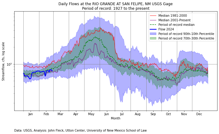
The different interpretations of the Upper Basin’s delivery obligations to Mexico under Article III(c) are well understood throughout the Basin. III(c) says that water for Mexico should be provided from “surplus”. If there is no surplus, the Upper and Lower Basins much each provide half the necessary water. But there has never been agreement on what that language means in practice. This unresolved uncertainty has enormous implications for how much water is available to each basin in the future.
The Lower Division States take the position that there’s no current “surplus,” as defined by Article III (c), thus the Upper Division States must deliver at Lee Ferry 50% of however much water is required to be delivered under the Treaty. The annual delivery is normally 1.5 maf/year, but under either the “extraordinary drought” provision of the Treaty, or Minutes, it could be less. In 2023, it was 1.4 maf.
The Lower Division States’ position would dictate an average annual delivery of 8.25 maf/year at Lee Ferry, 7.5 maf under Article III(d) + 750,000 af under Article III(c). The 8.25 maf includes an average contribution of 20,000 af/year from the Paria River and would be adjusted for the occasional annual delivery of less than 1.5 maf. Veterans of the negotiations that led to the 2007 Interim Guidelines will recall that Arizona’s Herb Guenther always brought with him to the meetings a posterboard sign with “8.25” written on it.
Going back to the 1970 decision by the Secretary of the Interior to set the “minimum objective release” from Glen Canyon Dam at 8.23 maf/year, the Upper Division States have consistently taken the position that their annual obligation Mexico has never been formally defined and, whatever it is, it is not 750,000 af/year, every year. While they vigorously complained, they never chose to formally challenge the issue in court or in Congress, perhaps because they concluded that they couldn’t show that any of their interests were injured. Today, based on post-2000 hydrology, that dynamic may have fundamentally changed.
The basic position of each basin has not changed. If anything, because the stakes are much higher, the positions have hardened. In a December 20, 2022, scoping letter to Reclamation, Arizona’s Tom Buschatzke, and Ted Cooke, wrote: “Article III(d) and (c) prohibits the Upper Division States from depleting the flow of the river at Lee Ferry below a rolling 10-year aggregate of 75 maf plus one-half of the Mexico delivery obligation. With reduced releases from Glen Canyon Dam potentially analyzed under the SEIS, if the 10-year rolling aggregate falls below the required aggregate volume, the Upper Division States could be subject to a “Compact call” that would require a reduction in consumptive use in the Upper Basin. In footnote 1, they add “A “surplus” currently does not exist because natural flows in the Colorado River have not exceeded 16 maf in the past 10 years.” In their August 15, 2023, scoping letter, the three Lower Division States write: “The Post-2026 EIS must analyze whether alternatives are consistent with the 1922 Colorado River Compact non-depletion obligations and delivery obligations to Mexico. Alternatives should include actions necessary to ensure compliance with such obligations.”
The Upper Division States are equally adamant that because of overuse in the Lower Basin, they currently have no annual obligation to Mexico under Article III(c). Note that I used the term “Lower Basin” because under the 1922 Compact, the Lower Basin includes the upper Gila River in New Mexico, where uses are small, Kanab Creek in Utah and Arizona, again uses are small, and the Virgin River, shared by Nevada, Arizona, and Utah, where uses are not small. The Virgin River is the water supply for the rapidly growing St. George area. As a state, Utah consumes the second largest amount of Lower Basin tributary water, about 150,000 af/year, albeit much less than Arizona.
In recent public presentations, Colorado Commissioner Becky Mitchell has stated that the Lower Basin’s total annual use, including tributaries and reservoir evaporation, were 10.5 maf in 2020, 10.8 maf in 2021, and 10.4 maf in 2022, far more than the Lower Basin’s compact apportionment (7.5 maf under Article III(a) plus 1.0 maf under Article III(b)). Their position is that the Lower Basin’s overuse is “surplus” water that must first be used to meet the 1944 Treaty obligations to Mexico before the Upper Division States have any obligation to Mexico, a position the Lower Division States do not agree with.
The situation is messy. As I explain below, Mitchell’s 10-plus million acre foot calculation is based on analysis that contains a hidden assumption about the correct way to measure water use, an assumption at odds with the method the Upper Basin has traditionally used to measure its own water use. But when one peels back the layers, it’s even messier. First, there is no agreement on whether the obligation of the Upper Division States to Mexico is calculated on an annual basis, a ten-year rolling aggregate basis, or something else (I’m in the something else camp). The predominant position the Upper Division States is, as mentioned in John’s comments, that the since the 1944 treaty provides for an annual delivery to Mexico (which can change), therefore, the obligation of the Upper Division States is determined annually. As can be seen by the language in the Arizona and Lower Division States letter, the Lower Basin states’ position is based on a ten-year rolling aggregate. The logic of this position is that the last sentence of Article III(c) states: “whenever necessary the States of the Upper Division shall deliver at Lee Ferry water to supply one-half of the deficiency so recognized in addition to that provided in paragraph (d).” Paragraph (d) is a ten-year requirement; does it make sense to add an annual requirement to a ten-year requirement? Further, the data necessary to determine whether a deficiency exists (and thus the obligation of each basin) would not be available until well after the water year is over.
My reading of the reports of the compact commissioners, their Congressional testimony, and the minutes of both the 1922 and 1948 suggests a third possible alternative. The negotiators of the 1922 Compact, the 1944 Treaty, and the 1948 Compact considered the surplus to be the difference between the average long-term natural flow of the river at the international boundary and 16 million acre-feet, the aggregate of the apportionments made by Articles III(a) and III(b). During the negotiations of the 1948 Compact, Colorado’s Royce Tipton and Arizona’s Charles Carson laid out the logic. Based on the comprehensive hydrologic analysis conducted by Reclamation (Appendix I of the 1947 Comprehensive Report), the estimated long-term natural flow below the confluence of the Colorado and Gila Rivers was 17.7 maf/year. Subtracting 16 maf left an average surplus of 1.7 maf, 1.5 maf for Mexico and about 200 kaf for surplus uses within the United States. Upper Division State officials argued that with this hydrology there was no deficiency. Colorado’s Tipton and Clifford Stone (its 1948 Compact Commissioner), however, did acknowledge that the location of the surplus was an important factor.
With their 1940s understanding of the river hydrology, the Upper Division States did not want the deficiency calculated either on an annual basis or a ten-year running average. They understood that in both cases, they would be required to deliver more water to Mexico than using the long-term average. Under an annual determination, there would be many years (~50%) when there was a deficiency. Under the ten-year rolling average, there would be long periods when it would be below 16 maf/year and there would be a deficiency (the 1930s drought period for example) but provided the long-term average was more than 17.5 maf/year, there would be no deficiency. Tipton also made the point that in the future, the construction of additional storage reservoirs (like Lake Powell) would effectively “equate” the river. Today’s problem with this approach is that in the 1940s, the basin’s water managers assumed a level of “stationarity” (future river flows can be predicted by what happened in the past) that because of climate change does not exist today.
An additional problem we have today is the calculation of the deficiency is based on the natural flow at the international border with Mexico, not Lee Ferry. Note that the Arizona letter states, “natural flows in the Colorado River have not exceeded 16 maf/year.” That statement is very likely true, but there are no data to back it up. Unlike Lee Ferry, there are no recent calculations of annual natural flows at the international border. There is no Colorado River system natural flow database. The existing database includes natural flows to Lee’s Ferry, but downstream to the Imperial Diversion Dam, Reclamation acknowledges that they have little confidence in these data and much of it is not based on reconstructed natural flows. Importantly, the existing natural flow database does not include the Gila River system.
The last widely published estimate of natural flows at the international border was completed by the Bureau of Reclamation nearly eighty years ago (Appendix I). These data were used during the 1944 Treaty ratification hearings and, to a lesser extent, by the 1948 Compact negotiators. Appendix I shows an average natural flow at the border of 17.72 maf/year. At Lee Ferry, it was 16.41 maf/year (based on1898-1943). Assuming a similar relationship between the flows today, from 2000-2023 the estimated natural flow at the border, including the Gila, would be approximately 13.5 maf/year (12.44/16.41 x 17.72). Note, because of climate change, which appears to have a greater impact on the southern tributaries of the Colorado River system, the relationship may no longer be reasonable.
Updating the natural flow database to include the Gila River has been suggested by Upper Division State officials, but Arizona has historically objected. Clearly this would not be an easy task and there would be large uncertainties, especially estimating with any certainty natural losses on the Colorado River below Hoover Dam and on the Gila River from the Phoenix area to Yuma under today’s climatic conditions.
Lower Basin Tributary Use
The Gila River is also the central subject of John C.’s second comment that Arizona, California, and Nevada should be concerned that including mainstem consumptive uses, tributary consumptive uses (including those in Utah and New Mexico), reservoir evaporation, and maybe system losses, the Lower Basin total consumptive uses exceed its compact apportionment of 8.5 maf/year. Alternatively, Lower Basin tributary consumptive uses far exceed 1.0 million acre-feet – if one believes Article III(b) was intended to only cover Lower Basin tributaries. The problem with this argument is that there is no 1922 Compact definition of “beneficial consumptive use” (the “commodity” the Compact apportions). This is especially important for the Lower Basin tributaries.
There are different interpretations among the states and between the basins of how “beneficial consumptive use” should be defined and therefore measured. Each has a strong legal argument in its favor. But their approaches result in vastly different numbers, and as my co-author John Fleck has written, “There’s not enough water for all the lawyers to be right.”
Article VI of 1948 Compact defines and provides a method measuring compact apportionments for the Upper Basin. The 1964 decree in Arizona v. California defines how to measure the mainstem apportionments made to the Lower Division States under the 1928 Boulder Canyon Project Act. Since the 1963 decision did not interpret the 1922 Compact and there is no Lower Basin Sub-Compact, there is no accepted or defined method for measuring 1922 Compact apportionments on the Lower Basin tributaries (and arguably the entire Lower Basin). The methods used by the 1948 Compact and the 1964 Decree are very different. The 1964 Decree uses the concept of “diversions minus return flows.” It comes from the language of the Boulder Canyon Project Act. Stream losses and reservoir evaporation from Hoover Dam to the points of diversion are not considered a use, but rather a limitation on the available supply.
The 1948 Compact approach for defining and measuring consumptive use under Article VI is based on what was referred to as the “stream depletion” theory. Consumptive uses for the Upper Basin and for the individual states are measured as the net impact of man-made depletions on the natural (AKA virgin) flow of the Colorado River at Lee Ferry using the “input-output” method. The 1948 Compact gives the UCRC the authority to change the method by unanimous approval. The UCRC has instructed its staff to identify an alternative to the input-output method, so this may happen soon. Article VI was one of the most debated and carefully written articles in the 1948 Compact. The negotiators had a clear objective in mind. They wanted to carefully define how to measure compact apportionments so that water made available for consumption through “salvage by use” would not count as compact apportioned use.
The issue of salvaged water was a major dispute among the basin states in the 1940s and 1950s. Simply put, salvaged water is water made available for use by the reduction of natural losses caused by the development of the river. The best example of salvage by use is Arizona’s Gila River. As the Gila River and its two major tributaries, the Salt and Verde Rivers, leave the rim country upstream of Phoenix, they have a combined average natural flow of over 2.0 maf/year (2.3 according to the 1947 report). As the river flows to its confluence at Yuma, in its natural state it loses about 1.0 maf/per year. By diverting and using the entirety of Gila River’s waters upstream, these losses are eliminated. Thus, Arizona can consume a million af/year more water than what the Gila River contributes to the natural flow of the Colorado River system. Under the “stream depletion” theory, which was favored by Arizona and the Upper Division States, Arizona is only charged for a million acre-feet of 1922 Compact apportionment. Under California’s “diversions minus return flows” theory, also favored by Nevada, all 2+ maf/year of Arizona’s Gila River consumptive use would be charged as 1922 Compact apportionment.
The Upper Basin adopted the stream depletion theory during an era when the states were competing for every acre-foot possible. They thought could benefit by 400,000 -600,000 af per year. Simply put, in years when the water was physically available, the Upper Basin could consume 7.9 – 8.1 maf/year while only depleting the natural flow of the river at Lee Ferry by 7.5 maf/year (their compact apportionment). The negotiators never contemplated that 75 years later, the water available to the Upper Basin would be far less than 7.5 maf.
During the negotiations of the 1948 Upper Basin Compact, the decision to use the stream depletion theory was thoroughly debated. Wyoming’s legal advisor, W. J. Wehrli, warned the other states that using this definition would benefit the Lower Basin far more than the Upper Basin. Additionally, he noted that it could reduce the amount of surplus water under Article III(c), potentially increasing the obligation of the Upper Division States to Mexico. Wyoming ultimately fell in line and agreed to the Article VI definition. During the Congressional debate over the authorization of the Central Arizona Project, Upper Division State officials (primarily Tipton and Stone) testified in favor of the stream depletion theory, arguing that the negotiators of the 1922 Compact intended this method to measure apportionments. Note, the compact does not include a definition of “beneficial consumptive use,” they made their case based on an analysis of the minutes and the use of the term “depleted” in Article III(d).
The Upper Division States make a rhetorically powerful public argument that in the face of climate change, overuse in the Lower Basin is the central problem in the Colorado River Basin that must be solved to reach a sustainable future where water use, and the available supply are in balance. The argument is that when mainstem uses, reservoir evaporation, system conveyance losses, and tributary consumptive uses (in Arizona, Nevada, New Mexico, and Utah) are added together, the Lower Basin’s total use exceeds ten maf/year, perhaps as high as eleven maf/year. The Lower Basin’s compact apportionment, however, is only 8.5 maf/year (perhaps 7.5 maf/year depending on how Article III(b) is interpreted), resulting in an overuse of at least 1.5 maf/year. Such an overuse has major policy implications:
- If the Lower Basin is overusing its compact entitlement, why should the Upper Basin, which is using far less than its apportionment, reduce its uses to help bring the system into balance?
- Should the Lower Basin’s overuse be considered “surplus” water under Article III(c)? If so, should this surplus water be delivered to Mexico before the Upper Division States have any obligation to deliver half of the deficiency to Mexico?
- These two questions have implications for Mexico, if the Lower Basin is overusing its compact apportionment, why should Mexico reduce its annual use?
The problem with the Upper Basin’s argument is that it’s based on the diversions less return flow theory. If the Lower Basin’s uses are calculated based on the stream depletion theory – the methodology the Upper Basin adopted in its own 1948 Upper Basin Compact, uses may not be greater than 8.5 maf/year.
|
Stream Depletion |
Diversions less Return Flows |
| Mainstem uses (a) |
6.6 maf/year |
6.6 maf/year |
| Reservoir Evaporation (b) |
0.5 maf/year |
0.86 maf/year |
| System Losses (c) |
0 |
0.45 maf/year |
| Tributary Uses (d) |
1.2 maf/year |
2.2 maf/year |
| Total |
8.3 maf/year |
10.1 maf/year |
Explanation:
a) Mainstem uses (deliveries from Hoover Dam) are very similar under both theories. Almost all mainstem uses are either fully consumptive or located low in the system. The average mainstem use by the Lower Division States over the last five years (2019-2023) is approximately 6.6 maf/year.
b) Under diversions less return flows the 0.86 maf/year is the average evaporation (2017-2021) from the December 2023 Reclamation study. Under the stream depletion theory, reservoir evaporation is calculated as surface evaporation less the natural losses in the inundation area that would have occurred had the reservoir not been built. This is how evaporation on Lake Powell is calculated. I estimated natural losses as .36 maf/year.
c) The 0.45 maf/year is from the December 2023 Reclamation study. Under the stream depletion theory, system losses are offset by salvaged water. As a practical matter, we have no idea how much salvaged water is currently generated on the mainstem below Hoover Dam, but we do know that the channel is much smaller today than it was before development. In 1945 during the Mexican Treaty ratification hearings, Colorado’s Royce Tipton estimated the number to be 400,000 af/year. I’ll assume they offset.
d)Under diversion less return flows, tributary uses are 2.2 maf/year, the latest data from the 2001-2005 Consumptive Uses and Losses and Report. Under the stream depletion theory, it’s reduced by 1.0 maf/year, the estimated salvage on the Gila River from the 1947 study. Because of climate change, losses today may be greater, but no data are available.
Thus, using the diversions less return flows theory, the Lower Basin is clearly using more than 8.5 maf/year, but under Upper Basin’s own stream depletion theory, it is not. Since the 1922 Compact neither defines nor prescribes a way to measure “beneficial consumptive use,” the basic question – “is the Lower Basin overusing its compact apportionment?” simply cannot be answered.
These disputes also point to the fundamental flaw with the states’ talking point that the 1922 Compact, the 1948 Upper Basin Compact, and the Mexican Treaty will serve as the foundation of the post-2026 operating rules. There is no agreement on what they say or mean. As the states continue their discussions with the goal of agreeing on a state proposal, they need to consider addressing the disputed compact issues in a straight-forward manner. Leaving these critical uncertainties for future generations to handle (like we have in the past) is no longer possible and asking the Supreme Court for a resolution will likely make matters worse, not better.