That giant pipeline from a wet place? Not gonna happen….

This comes up every drought, and people in the Pacific Northwest are worried again that we’re gonna steal their water:

It may sound like a loopy idea, but there have been a lot loopier ideas that came true. And this is the American West, where we make a living taking water and moving it someplace else. And the divert-the-Columbia-to-California has been in the pipeline since the 1960s at least. Every time a new generation comes across the idea it sounds fresh, even sensible to some people. “Each day, the Columbia River dumps in the Pacific Ocean 90 billion gallons of fresh water,” said Los Angeles County Supervisor Kenneth Hahn in 1990. “That is 3.7 billion gallons an hour, 61 million gallons a minute and 1 million gallons a second. That is wasteful and sinful.”

Robert Young, in his wonderful book on the value of water, explains why water is different than most other commodities we happily move long distances:

[T]he economic value per unit weight or volume of water tends to be relatively low, placing water among commodities which economists call “bulky”. Capital and energy costs for transportation, lifting, and storage tend to be high relative to the economic value at the point of use.

We talk about how water is essential for life, and therefore of extremely high value, but the portion the water we use that falls into that “we’d die if we didn’t have it” category is tiny. Again, Young:

In the arid western United States, for example, average residential water withdrawal frequently reaches 500 liters per capita per day. Only a fraction of a percent of this use is for drinking; nearly half may be applied to irrigate lawns and gardens, and most of the remainder is for bathing, flushing toilets, and washing cars.

Or, as George Skelton more colloquially explains of the sudden rash of water importation schemes popping out as California slips ever deeper into drought:

Let’s get right to the point: They’re all nutty. Politically and financially unfeasible.

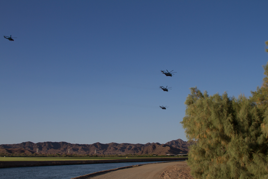
Yuma’s economy in a single photo

military helicopters over Gila main, Yuma County. By John Fleck

military helicopters over Gila main, Yuma County. By John Fleck

People I talked to on my recent trip to Yuma repeatedly ticked off the three components of the regional economy:

  1. ag
  2. federal (mostly military)
  3. tourism

If you count me as “3” on a Gila main canal ditch bank as a squadron of military helicopters flew over, this picture captures them all.

I think it’s fair to say the salt cedar on the right is not contributing to the local economy, though the Yuma area versions of this eurasian visitor are pretty impressive.

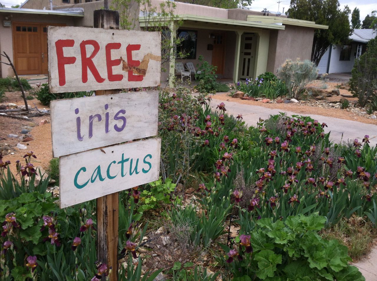
Lissa’s iris and cacti, in the manner of Johnny Appleseed

Free iris and cactus day at the Heineman-Fleck house

Free iris and cactus day at the Heineman-Fleck house

It was free iris (and a little cactus) day today at the Lissa Heineman Garden and Art Emporium.

The garden, a project of 20-plus years’ duration, has come to be Lissa’s best work of art (at least that’s what I think), a constantly evolving thing that is great in part because it will never be done. The purple iris (and maybe a few brown ones you can’t see here) are the only remnants of the landscaping we inherited when we bought the house in 1993. They started as a clump of maybe a dozen, living off to the left of this picture where the cholla and some other cacti dominate a mound. Lissa’s been separating and spreading the iris out for years, and culling extras that she puts in bags on the sidewalk. Their offspring are all over the neighborhood now.

The color is wonderful at bloom time, but it shifts through the seasons and is always lovely. Like the rules that constrain a haiku, our attitudes toward water use place boundaries that influence its direction, and the color palette of the desert is an integral part of the piece – both the desert colors of the soil and cactus, and the counterpoints of the small wetter bits that Lissa arranges within it.

It’s sculptural, with the great forms of three piñon of varying sizes and the wonderful mass of the cactus, but a tendentious physicality – more within Lissa’s influence than control, which is part of what makes watching her relationship with this particular piece of art so enchanting.

Free iris today was fun, with neighbors and visitors to a garage sale across the street grabbing them up as fast as I could bag up Lissa’s culls and put them out on the sidewalk. The audience loves this work of art, and the bags give them a chance to join in.

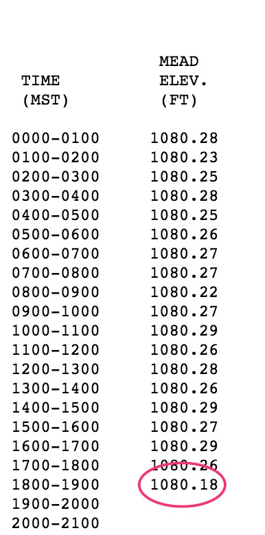
1080.18: Lake Mead breaks another record, lowest since it was filled

At the 7 p.m. Pacific Time reading this evening, the surface elevation of Lake Mead dropped to 1080.18 feet above sea level, surpassing the previous low set last August to mark the lowest the big Colorado River Reservoir has been since it was filled in the 1930s:

Another Lake Mead record

Another Lake Mead record

The record came as Hoover Dam’s operators ramped up water releases to meet Saturday evening power demands. Current projections call for Mead to continue dropping through June, as continued downstream demand in Arizona, California and Nevada outpace upstream inflows.

It is again worth noting that this is in large part a demand-driving decline in Lake Mead. Water deliveries from the Colorado River’s Upper Basin are meeting that basin’s legal requirements, and in fact this year are projected to be above the minimum legal requirement. But the Lower Basin states have still not come to grips with what has been called a “structural deficit” – higher legal entitlements to water than the river system can provide under these circumstances. That has left the Lower Basin dependent on wet year surpluses. With the drought, those surpluses have evaporated, and 1080.18 is the result.

The previous record was set last August, which broke a record set in 2010. In other words, the reservoir keeps stair-stepping down, what you’d expect from a system in which water use exceeds supply.

There is an argument to be made that an empty Lake Mead is, in fact, the reservoir being used precisely for the purpose for it was built: storage in wet years, for use in dry years (now). The question now is one of risk tolerance: how much more risk are downstream water users willing to tolerate as Mead drops further, and what if any additional steps need be taken to protect the Lower Basin’s “junior users” – those whose water rights will be curtailed (particularly Arizona’s – here are the basics of what happens there should Mead continue to drop) should the lack of surpluses continue.


In Coachella Valley, poor people who are always in drought

The Desert Sun has been doing a great series on California’s drought, but this is surely the most important of the stories. While the rest of California worries about a dwindling supply, some poor residents of the palmy, leafy, lawny Coachella Valley, playground of Southern California wealth, don’t have a safe drinking supply at all, drought or not:

Carmen Vargas has been buying bottled drinking water for more than 20 years. Like cooking, cleaning and gardening, it’s a weekly ritual of family life on her patch of the California dream.

Harmful, naturally-occurring contaminants such as arsenic have made it impossible for Vargas and her family to drink the well water pumped to the mobile home park near the San Jose Community Center in Thermal.
The only alternative is costly and inconvenient.

So every week Vargas, 66, journeys 13 miles to Cardenas Market in Coachella or 21 miles to Costco Wholesale in La Quinta, lugging 24-packs of bottled water and 5-gallon jugs to her car and then home, where she stores the rations of clean water in the living room.

And it’s not just Coachella. Poor water quality plagues poor communities. If drought is not having enough clean, safe water to do the things you need, these people are always in drought. Read the story.

update: Interesting comment from Peter Gleick


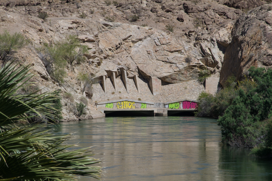
“I’m stuck in my ways.”

Gila Gravity Main tunnel, Arizona

Gila Gravity Main tunnel, Arizona

It was only when I was captioning and filing my pictures from my recent tours of the old bits of Arizona’s Lower Colorado River water infrastructure that I noticed what the graffiti here said: “I’m stuck in my ways.”

It’s a surreal spot – springing from the side of a harsh desert canyon, a remarkable flow of water, bigger than the Rio Grande. It’s one of the two tunnels on the Gila Gravity Main Canal, which carries about 200 billion gallons of water per year (an average in the neighborhood of 1,000 cubic feet per second, or 700,000-plus acre feet per year for you water nerds) from Imperial Dam to farmers to the south. Mittry Brothers Construction Company built two tunnels in 1937-38 under a contract with the U.S. Bureau of Reclamation. The canal hugs the foothills of the Laguna Mountains as it winds down the valley, often with the east bank simply carved out of mountain rock.

In winter, this water grows your lettuce.

Sources:

  • History: Gila Project, by Tina Marie Bell, USBR, 1997 (pdf)
  • Water numbers: Colorado River Accounting and Water Use Report, Arizona, California, and Nevada, 2013 (pdf)
  • Current Gila Main diversions: USGS

Lake Mead, always with the record setting lows

As I write, the surface elevation of Lake Mead is 2 1/2 inches away from setting yet another record for its lowest levels since it was filled in the 1930s.

Henry Brean, with characteristic flair, writes that the threshold will likely be crossed Sunday:

The last time Lake Mead was this low was May 1937, the same month as the Hindenburg explosion.

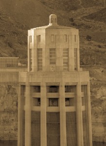
Hoover Dam from the Arizona side at sunset, Feb. 27, 2015

Hoover Dam from the Arizona side at sunset, Feb. 27, 2015

For what it’s worth, my money’s on late Saturday evening. I’ll probably stay up late and watch, maybe livetweet it or something. Water policy, especially in the Colorado River Basin, lacks for grand drama, so we storytellers must take it where we find it.

Two records ago I made a mad dash across two states to be there when the reservoir’s level dropped below a similar record and groped unsuccessfully for a storyline that might help me explain:

I tried this morning to explain to one of the tourists visiting Lake Mead the historic significance of the bathtub ring. He had jumped out of his car on an overlook on the Arizona side of Hoover Dam, and he was doing that thing where you hold your digital camera out at arms length to get yourself in the picture.

I told him it was a historic picture – that today Lake Mead had dropped to its lowest level since they built Hoover Dam in the 1930s. He looked puzzled.

Him: “Why’s it so low?”

Me: “Drought upstream. Water use downstream.”

Him: “It’ll fill up some day.”

And he jumped back in his car, headed for Vegas. This is how we do drought, American style.

Brean’s headline writers blamed “savage drought” for the problems, but drought’s a slippery word. My Oxford American defines it as “a very long period of little or no rainfall,” and I have a lot of respect for a good dictionary’s ability to capture the meaning a word actually carries in its common usage. But in this sense of the word, “drought” falls short.

We are, indeed, laboring under a very long period of less precipitation in the Colorado River Basin than we had come to expect, but Lake Mead is empty because, as that slow burn has unfolded, we have continued to take just as much water as ever out of the great reservoir.

That cannot continue indefinitely.

In a Colorado River shortage, Central Arizona will be fine for now

The folks at the Central Arizona Project and Arizona Department of Water Resources held a workshop yesterday to discuss the implications of Colorado River shortage. I didn’t have time to get down there, but Summer Pauli covered the basic message for Cronkite News Service:

Arizona’s communities, industries, mines and Native American tribes aren’t likely to be affected during the next five years if federal officials declare a shortage on the Colorado River, officials said Wednesday.

While Central Arizona Project rates may rise, deliveries for groundwater replenishment would be eliminated and central Arizona agriculture would take a hit, leaders of a workshop held at the Arizona Department of Water Resources said the state is ready for a shortage on the Colorado.

(My attempt at sussing out the excruciating details is here.)


Some breathtakingly bad California drought journalism

I’ve been avoiding wasting time on the “someone’s wrong on the Internet about California drought” genre – so much is being written that is so bad. But Elijah Wolfson’s Newsweek cover story (I won’t link, find it if you must) is so breathtakingly well-researched-and-written-ly bad that I’ll let it stand in for the genre:

We’re driving in my beat-up Volkswagen through the Central Valley, just south of Sacramento, and even here the effects of the drought are stunning: the hills to the west, usually soft and green, are burnt-crisp and yellowed. The fields spreading for miles in both directions are also toast; they look as if they would crumble under your feet. Here and there, crops still live, but they are hedged in on all sides by death.

Let’s compare that image with the reality of California agriculture, as authoritatively described in U.S. Department of Agriculture crop data. Acreage for almonds, grapes, and strawberries, California’s money crops, have been flat or even trending up during the drought. Yields have been down in some cases, and the struggle for water has been real. Farmers in many cases have been fallowing lower value crops to move water to those money crops (hay is down 114,000 acres, cotton is down 125,000 acres, for example). The drought is real. Land is being fallowed, but the majority of California’s agricultural land remains in production.

Wolfson visits an almond orchard where the farmer has run out of water, and the trees are dying. This is an important, and sad anecdote.

But ethically responsible journalism requires you to match up your anecdotes with data. In the big picture, almond acreage is up. An anecdote that suggests the opposite is bad journalism.

To be fair, Wolfson at one point slips in some data (5 percent of California cropland fallowed) that undercuts his “hedged in on all sides by death” imagery, but when imagery higher in a story overpowers data buried deep within, we can see the rhetorical game being played. And at that, he does it poorly, noting that agriculture “losses of over $2 billion and 17,000 jobs.” There, again, no context. Q: $2 billion of an agricultural economy of what size? A (which he doesn’t give): $33 billion. Ditto the jobs? Again, he doesn’t say, but in the latest data from the Bureau of Labor Statistics, California jobs in crop production (the key sector Wolfson seems to be laboring to describe) have actually gone up in the last couple of years. What explains that? The answer, as Jeff Michael has explained, is adaptation to the conditions of drought, not fleeing to a wetter part of the country as death presses in on Californians from all sides. There are so many caveats that I’m being as dangerous as Wolfson, but isn’t the point of journalism to help negotiate that dangerous terrain for your readers?

Scattered crops “hedged in on all sides by death” is great rhetoric, and it may describe the subset of the land he saw. Yes, in some places, things are very bad. In others, less so. The differences matter. Real drought in California is important, and serious, but it is a far richer, more complex story than the misleading picture Wolfson sketches from the window of his battered VW.

Santa Fe NM’s water rates are really high

Brett Walton’s annual U.S. municipal water rates survey is out. They show that, as post-World War II infrastructure nears the end of its useful lifespan, the cost of keeping things together is rising:

Continuing a trend that reflects the disrepair and shows no sign of slowing, the price of residential water service in 30 major U.S. cities rose faster than the cost of nearly every other household staple last year, according to Circle of Blue’s annual water pricing survey.

Brett’s analysis confirms the conservation story we’ve been hearing. Here’s a discussion of Austin, which is not alone:

Though rates are steadily increasing, residents are lowering bills by using less water.

Indeed, many households are conserving. Austin, Texas, for example, sold nearly 10 billion gallons less water in 2014 than in 2011, a 20 percent reduction. The city achieved this by dramatically increasing its rates for the highest-volume users while enforcing lawn-watering restrictions that were prompted by a record drought, according to David Anders, assistant director of finance for Austin Water.

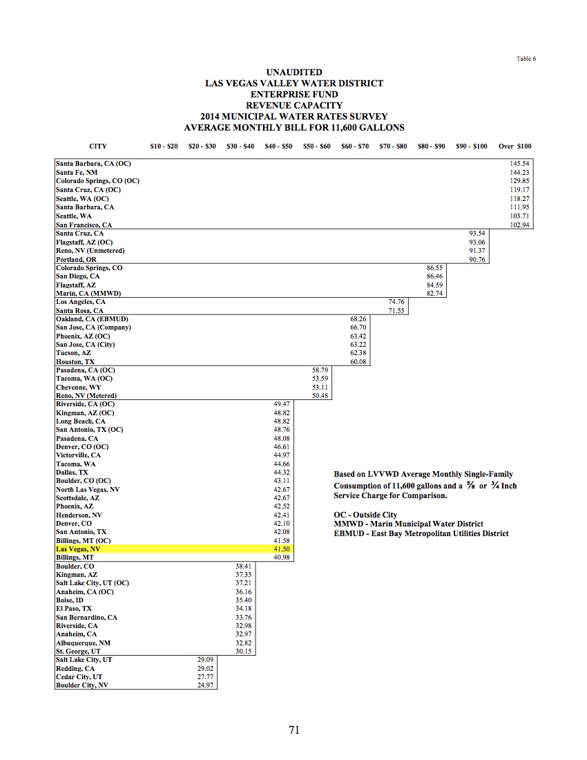
The news for New Mexicans is that Santa Few has the highest water rates among the 30 cities surveyed, with an average of $157.78 using Brett’s methodology, a family of four using 100 gallons per person per day.

That’s consistent with a survey done by the Las Vegas Valley Water Authority, which shows Santa Fe with the second highest water rates among their sample of 70-plus western U.S. municipal water agencies:

Courtesy Las Vegas Valley Water Authority

Courtesy Las Vegas Valley Water Authority


Only Santa Barbara, Calif., is higher in the LVVWA survey.

My home town of Albuquerque has insanely cheap water.