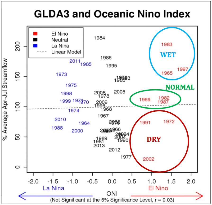
What does the growing El Niño oceanic pattern mean for the Colorado River Basin? Best to just shrug, and say the statistics are too small to say much of anything conclusive. In the nine El Niño years since the 1960s, three have been wet, three have been in the middle, and three have been dry. Here’s a graph from the agenda packet for Thursday’s meeting of the Central Arizona Water Conservation District board (“GLDA3” is jargon for natural flow at Glen Canyon):
El Niño on the Colorado River
When you think about the geography, this makes sense. El Niño’s strongest effect is the southern tier of states, but most of the Colorado River’s flow comes from mountains to the north, which is in the no-man’s land between wet and dry during El Niño years. Eyeballing the chart, it looks like stronger El Niño’s tip the odds slightly in the direction of wet, and this is a strong El Niño. But now the statistics are so small as to be meaningless.
We love to talk about “the big El Niño year of 1983 when we nearly lost Glen Canyon Dam,” but as you can see our little oceanic friend is no guarantee.
I would say “warm climate” is a fair description of the Imperial Valley in California’s southeastern corner. It’s 109 degrees there this afternoon (43C).
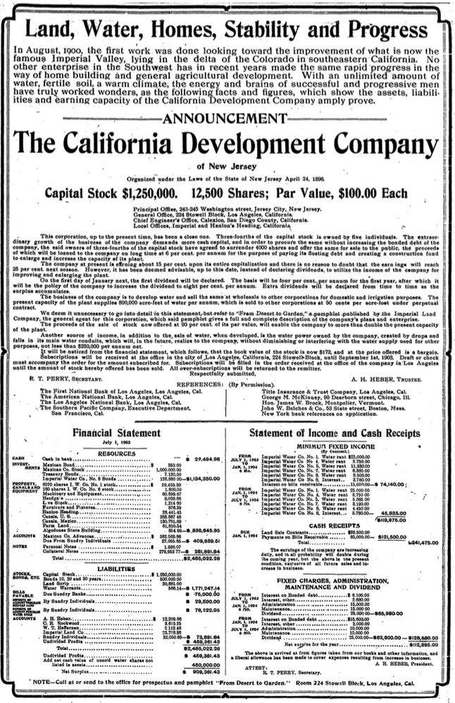
Below is a great addition to my collection of adverts as the real estate boosters tried to lure folks to the desert during that oddly magical time when waves of immigrants were first imagining what to do with this place. This is from an Aug. 9, 1903 display ad in the Los Angeles Times by the California Development Company, hustling for investors in the “California Development Company.” This is the outfit, run by Charles Rockwood, that first brought water to the Imperial Valley. Rockwood was always hustling money, and never quite had enough to make a go of it. It was one of the most spectacular early failures of the private irrigation movement, and eventually it took government to make it work. Bill deBuys’ Salt Dreams, one of my favorite Colorado River books, is a great account of that crazy time.
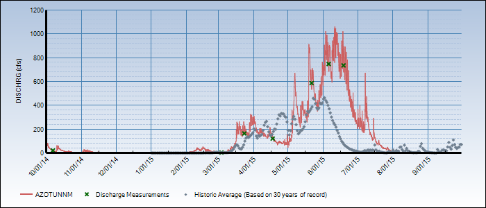
Our remarkably rainy spring and summer in New Mexico and southern Colorado has increased the allocation of San Juan-Chama Project water, which brings some of New Mexico’s Colorado River Basin water to the central part of the state. After a bad start to the year, flows have been above average basically continuously since the first of May:
San Juan-Chama Project flows
The mid-June allocation was just half of a normal year supply, but that’s been steadily rising, and now is up to 85 percent, according to the Bureau of Reclamation. And that’s based on what we’ve got now. With the rainy season underway, that could continue rising, with 90 to 95 percent looking like a real possibility. That’s still a shortfall, for only the second time in the project’s 40 years history. But less of a shortfall, but by a significant margin, than water managers had feared.
The water provides supply to Santa Fe and Albuquerque. Both cities have buffers so a shortfall in any one year doesn’t have an immediate effect.
For context for those in other parts of the “greater” Colorado River Basin (those places that use Colorado River water, whether they’re in the actual physical basin or not), the total San Juan-Chama Project allocation is less than 1 percent of the basin’s human water use. It’s one of those crazy-sounding projects we did back in the day to move water long distances from where the rivers are to where the people live, with three dams in San Juan Mountain headwaters in Colorado diverting water through 27 miles of concrete-lined tunnels beneath the continental divide.
People who fly into desert cities often look down out of the airplane on approach and comment on golf courses. I have nothing against golf. If I had swimming pool data, that would make a fun post too.
Counties are a super troublesome geographic unit of measure for water, because they lack uniformity. Like Jefferson County, Colorado, for example. That’s a weird county.
Percentages are a super troublesome measurement, because if you’ve got farming in your county (like, say, Maricopa and Bernalillo) that throws off the calculation by making golf look, in comparison, small.
I’ve got some reservations about the data. I left Clark County, NV (Las Vegas) off the chart because the numbers there just didn’t seem to jive with other data I have.
This is in no way comprehensive. I just picked some counties here that I’m interested in because I’ve always wanted to experiment with one of those “Ten BLANKS that BLANK” clickbait headlines.
“Regulatory arbitrage” is the business practice of shifting one’s operations to exploit differences in regulatory regimes. This often involves a geographical change, such as moving a factory to a place where environmental regulations are less stringent.
That seems to be what’s going on in southeastern Arizona, where California nut farmers are moving into the San Simon Valley, planting pistachios and pecans, and pumping groundwater. From a great Tony Davis story discussing the trend:
Chima and Barton Heuler are California transplants who sit on opposite sides of the issue. They both moved their farming operations here because they were tired of seeing water transferred away from crops due to the drought. Chima says he was tired of excessive regulation in his former state.
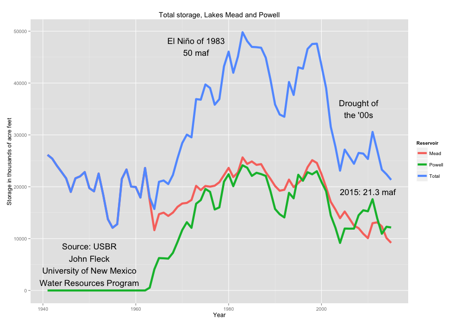
Updating my Colorado River reservoir storage spreadsheet today to make a graph for a friend was a pretty discouraging exercise. Lake Mead and Lake Powell, the system’s two massive reservoirs on which 9 states and a gazillion people and farm acres depend, are at their lowest combined level since 1967, when they were filling Powell for the first time:
Colorado River storage
I style myself as the optimist in the room. Staring dimly into the future, I think I can see what solutions to the West’s water problems might look like. My optimism comes from things like this, which appears on the agenda of tomorrow’s meeting of the Imperial Irrigation District board of directors. It’s an information item about an Arizona plan to conserve close to 100,000 acre feet of water this year, primarily by fallowing agricultural land in central Arizona:
This is water that will sit in Lake Mead, unused. It’s the kind of step that encourages me, but the details of what’s needed to carry it out help explain why Lake Mead is dropping faster than my optimism can keep it propped up.
It’s encouraging because it shows flexibility in the water use system. To slow or stop Lake Mead’s fall, we need to use less water by doing things like this. Central Arizona’s got an agricultural buffer to work with, imported Colorado River water pumped uphill via the Central Arizona Project. This agreement calls on some of that buffer.
But the friction here is discouraging. This is not as simple as just saving water. Dustin Garrick’s fascinating new book, Water Allocation in Rivers Under Pressure, goes a long way toward articulating what I’ve only been seeing dimly as I watch this process. Garrick’s work takes a deep look at the “transaction costs” of moving water around and, more importantly, in making the institutional changes (the changes in governance structures and rules) needed to change the way we move water around. (The “Coase” of the headline is economist Ronald Coase, whose work on transaction costs is incredibly important here if you wanna go full wonk on this stuff.) One of the key takeaways from Garrick’s book is that it’s not enough to point to how the rules are all messed up and Lake Mead is dropping as a result. We’ve got to really understand why the rules are hard to change. Those are transaction costs.
We’ve got a mechanism here that’s relatively straightforward on the water conservation side – fallow land in Arizona, leave water in Lake Mead. But the bureaucratic side is a nightmare of transaction costs. Load up the full document linked above and scroll down, and you’ll see that in order for Arizona to get credit for this arrangement under the Colorado River’s formal water accounting system, the agreement needs 16 signatures.
From the newly released archive of British Movietone newsreels, U.S. Secretary of the Interior Harold Ickes in October 1938 hits the button to open the gates on Imperial Dam, diverting the first Colorado River water into the All-American Canal and on its way to irrigate the farms of the Imperial Valley:
The newsreel makes it sound as though the parched desert had never before seen water, but that is untrue. The dam and canal simplified delivery of water the Imperial Valley, but irrigation had been underway there for decades. In 1934, there were 245,117 acres of farmland in Imperial County, according to the Census of Agriculture. In 1939, that had risen to 274,808. Alfalfa was a dominant crop, with 114,164 acres yielding 2.99 tons per acre. (2012 production was 7.4 tons per acre, according to latest ag census data. Like much of agriculture, productivity has risen.)
Even then, this was vegetable and melon farming country. In 1939, 56,728 acres were reported in various vegetable and related crops, nearly half of that in carrots, cantaloupes, muskmelons, and the like.
New Mexico’s Interstate Stream Commission yesterday formally approved the creation of a “New Mexico Central Arizona Project Entity,” a governance gizmo needed to move forward with a proposal to divert Colorado River tributary water from the Gila River in New Mexico:
Interstate Stream Commission members have approved a resolution designating a 14-member unit to design and build the Gila River diversion project in southwestern New Mexico.
The resolution, OK’d during Wednesday’s commission meeting in Albuquerque, identifies the parties making up the so-called New Mexico CAP, or Central Arizona Project, entity. The creation of the unit was necessary to proceed with the project that provides for the annual diversion of water from the Gila River for use in Catron, Grant, Luna and Hidalgo counties.
Parties making up the unit are the county commissions of Catron, Grant, Luna and Hildalgo; the governing bodies of the cities of Deming and Lordsburg and the village of Santa Clara; the Fort West Irrigation Association; the Gila Farm Irrigation Association; the Gila Hotsprings Irrigation Association; the Hidalgo Soil and Water Conservation District; the San Francisco Soil and Water Conservation District and the Upper Gila Irrigation Association.
There are many reasons to be skeptical about this project, the most important of which is that someone has to come up with gazillions of dollars in return for very little water. But there’s also reason to be skeptical on governance grounds.
All along, this project has been driven by the staff of the New Mexico Interstate Stream Commission, a state agency. Now it is being handed off to what, at this point, is a thing of paper. One of the central points scholars who study water governance institutions have found is that building good ones is really hard, taking a concerted effort that is most effective when it grows out of repeated interactions among the communities that live within the boundaries to be governed (see here, here, and here). This process has not played out that way, which means that the “New Mexico CAP Entity” is not made up of people and entities that have done the heavy lifting needed to develop the levels of trust, reciprocity, and shared understanding of the region’s resource issues that will be required to make this thing work.
This would be different if the project had been driven all along by the people and entities now tasked with carrying it forward. You can’t just slap down some governance and expect it to succeed at a problem like this.