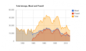
More than a million acre feet of water disappeared from Lake Powell in the latest U.S. Bureau of Reclamation operational forecast for the 2015 water year, translating to a 13 foot drop in the big Colorado River reservoir’s projected end-of-September elevation in this month’s forecast compared to just a month ago.
The change in this month’s USBR “24-Month Study” (pdf) is the latest fallout from a dismal March, with hot temperatures and little snow across the Colorado River Basin.
For now, the forecast will have little impact downstream at Lake Mead, the reservoir that supplies Arizona, Nevada, and California. Mead is at historically low levels (where by “historically” I mean “lowest since it was filled”) and is teetering on the brink of a shortage declaration, so the numbers here matter, but the latest forecast suggests the odds remain against a 2016 formal shortage declaration (gory details of what “shortage” means here). But the forecast contains a caveat that, if the crappy weather continues, released from upstream Powell to downstream Mead could be throttled back later this year, which would Mead closer to the shortage line by the end of the year.


As a long-time member of California’s water industry and someone who knew John from his Pasadena days I very much enjoy reading his observations.
As I read BuRec’s quarterly report (the supplement that accompanies the April 24-month study but wasn’t released until the 16th), BuRec officially declared Powell/Mead level balancing tier logic of 3575+,1075- was satisfied (as expected) on 31 Mar 15 which triggers the release of an additional 0.77 maf (from 8.23 up to 9.0) from Lake Powell under the “Upper Elevation Balancing Tier” per Section 6.B, pages 50-52 of the Interim Guidelines. See http://www.usbr.gov/lc/region/g4000/24mo/2015/April-Chart.pdf
At today’s 3590′, Lake Powell’s topography is such that it will lose 1 foot of elevation per 90,860 acre feet drop in content so if the extra 0.77 maf is sent down to Lake Mead (a near certainty), Lake Powell will lose an additional 8.47 vertical feet attributable to operation under the “Upper Elevation Balancing Tier”. http://lakepowell.water-data.com/?use_af=1.9835
Looking today at the remaining snowpack (graph at http://snowpack.water-data.com/uppercolorado/index.php), we see it is tracking 2012 almost exactly, being 53.5% of the April 25th average. It follows that there will be no runoff bump in Lake Powell elevation this spring; indeed BuRec is holding Lake Powell flat at 3590′ (~ minimum launch depth for Antelope Point), in effect scraping off the snowmelt to get a start on the extra 0.77 maf that needs to be released.
In fact, calendar year 2012 is so similar to 2015 that we might append 2012’s tail (copy/paste in Photoshop) to the 15 April 2015 Lake Powell graphic to estimate where it will be on 1 Jan 16 (which automatically builds in the summer monsoon). After subtracting off the extra 8.47 feet from balancing, this works out to an elevation of 3545′, which renders Wahweap unusable (minimal elevation 3558′) and finalizes the economic death spiral of Page, AZ.
As you know, academic scientists are not on the same page as BuRec in terms of optimal use of historic water data, the Bureau seeing cause for optimism from equal weighting of wetter decades from the distant past whereas Bayesian statistics and global warming paint a very different predictive picture for the near future.
If 2016 has a mediocre snowpack with Lake Powell starting the year at 3545′, we may wish to revisit a couple of easy conservation steps — the 0.38 maf per year of irreversible seepage into Navajo sandstone (Nevada’s entire Colorado River allocation) per 1999 and 2013 publications of hydrologist T Myers (cv here: http://tinyurl.com/qxn5t2p) but especially the two million acres in irrigated alfalfa and dairy forage (10 maf/yr per UC Davis) before asking the public not to shower or brush their teeth. It seems the rain didn’t follow the plow into the Mojave either.
Disclosure: Our home abuts the CAP terminus; our well draws from the Avra Valley aquifer though not via Tucson’s controversial recharge ponds.