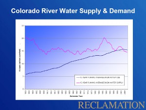
There’s a U.S. Bureau of Reclamation graph making the rounds that captures the core issue going forward on the Colorado River Basin.
I first noticed it in Jennifer Pitt’s congressional testimony in early April. At the “Implications of Lower Lake Levels” symposium I just attended in Las Vegas, it showed up in three different talks (Terry Fulp, Brad Udall and Paul Miller – all links to PDFs of their slides).
It also features prominently in the proposal submitted last year by the Colorado River Basin states (another big PDF) that evolved into the Colorado River Basin Water Supply and Demand Study now underway. Here’s how that proposal described the problem in a nutshell:
The Basin States include some of the fastest growing urban and industrial areas in the United States. Nevada, Arizona, and Utah are each ranked among the five fastest growing states in the country. The continued growth and sustainability of the communities and economies of metropolitan areas such as Albuquerque, Denver, Las Vegas, Los Angeles, Phoenix, Salt Lake City and San Diego is tied to future water availability from the Colorado River. Based on a compilation of population projections from various water districts throughout the Basin States, the population dependent on the Colorado River and its tributaries could grow by 25 million over the next 40 years, leading to an increase in water demand of as much as 5 maf annually. Demand for water for other uses including the environment, recreation, and Native American water rights settlements also continues to increase. Potential future increases in temperatures in the Basin, as have been observed in most of the Basin over the past 30 to 40 years, would increase evaporation-transpiration from vegetation, leading to further increases in water use and water lost from evaporation from reservoirs.
There are a lot of embedded assumptions lurking behind The Graph that I haven’t yet worked through. But I like to think of its simplicity in Darwinian terms. Its rapid reproduction and dispersal in the wild suggests it is telling a story that serves a lot of our needs.


Yep, that really does tell the story in a nutshell. I’m going to link to your post in a new water blog the Colorado River Water Conservation District is helping to support at Summit Voice and try to follow up on this myself. Hoping to do a Colorado River tweet-n-blog tour this summer, from the headwaters all the way to the delta, if I can find a few supporters and sponsors. Keep up the good work!
What the graph tells me is that Powell and Mead will never be full again. And while everyone insists it’s absolutely impossible to re-open the Compact, the fact is that we are in a new paradigm on the river – one that calls for new management strategies. And the Shortage Sharing Agreement doesn’t fully address the needs of the basin going forward.
Pingback: The water blog: Because everybody needs it « Summit County Citizens Voice
Pingback: Waterblog: An age of limits on the Colorado River? « Summit County Citizens Voice
The Colorado seems to have hit its “peak water” point, and now any new discussion of compact politics will have to re-apportion according to the long-term average, hopefully while considering ecosystem needs (yes, “environmental flows” is such a stupid term). Thanks for sharing John.
This graph is inaccurate because it uses the typical “straight line” method of projecting demand on trend. Engineers love it, but social scientists (me!) will tell you that demand is a lot more flexible. Will it happen? Only if we continue with business as usual.
Oh, and don’t forget that I’ve said this for years…http://aguanomics.com/2009/05/lake-mead-still-draining.html and http://aguanomics.com/2008/02/lake-mead-in-trouble.html
David –
I think you misunderstood the X axis. This isn’t a projection of future supply/demand. These are historical numbers.
Pingback: River Beat: The Conversation About Limits : jfleck at inkstain
Pingback: Colorado River water & climate change summary (illustrated) | Peaceful Uprising
The graph is useful information, but doesn’t tell the whole story as far as New Mexico is concerned. We do receive some Colorado basin water from the San Juan River, via the Azotea tunnel to Heron L. (through the Continental Divide), thence down through Abiquiu and Cochiti lakes to Albuquerque. However, we also receive the bulk of our water via the Rio Grande, on the east side of the divide, which furnishes replenishment of the Santa Fe group of rocks, thus providing the main aquifer for Santa Fe, Albuquerque, Las Cruces and points in between, and then south to Texas and Mexico. This major regional river is fed from the Southern Rockies (including the Sangre de Cristo mtn.) mainly in southern Colorado and northern New Mexico.
There is no doubt that we are in serious times water-wise, and as a lifelong southwestern desert dweller, it pains me to see multitudes entering from the east who want to plant fruit trees and have huge grass lawns, and other multitudes coming up from the south with no legal right of passage. These are ongoing major stresses to our water supply.
I hope you continue to follow up on this story, as it is our life blood.