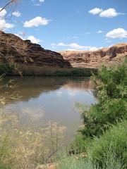
There’s a moment when you’re driving across the deserts of the southwest as the road tops a rise and you get your first view of the ribbon of green along a river.
That’s where the towns are, and that’s where the cool is, a break in both temperature and color – from hot to a bit cooler, from the reds, browns and yellows of desert rock and earth to the riparian greens of cottonwoods and, now, salt cedar, dipping their roots in the groundwater that leaves as much or more river underground as you see above. The striking thing is always how sharp the boundary is between dry and wet. Add a town, and you often have irrigation, a few fields tacked along the bottonlands on either side of the river. And, often, a place to buy ice cream. I learned this as a kid, on epic ’60s family car trips through The West, before the days of air conditioning, and I’ve loved the moment ever since.
Lissa and I shared the experience numerous times over the last week on a road trip up through Four Corners country – in Bloomfield on the San Juan, at Hite where the Colorado meets the Dirty Devil in the canyon country of southern Utah, as the interstate meets the Green. And one of my favorites, the site where this picture was taken, on the Colorado River just upstream from where the highway drops down from the north, past the entrance to Arches National Park.
I had occasion on this trip to pick up a copy of John Van Dyke’s “The Desert”, an essay written a century ago about Van Dyke’s strange and wonderful wanderings of the lower Colorado. He saw it too:
The desert terraces on either side (sometimes there is a row of sand-dunes) come down to meet these “bottom” lands, and the line where the one leaves off and the other begins is drawn as with the sharp edge of a knife. Seen from the distant mountain tops the river moves between two long ribbons of green, and the borders and the gray and gold mesas of the desert.

