Aquifer replenishment works. Sort of. And depending on what you mean by “works”.
That’s the message in a new paper ($$$-walled) from Brian Thomas and Jay Famiglietti at NASA’s Jet Propulsion Laboratory looking at groundwater levels in California’s Coachella Valley.
Coachella is the northwestern extension of the Salton trough, edging the Salton Sea and spreading up across some pretty sweet desert farm land (add irrigation water and you get dates!) into the golfy oases of Palm Springs. With very little surface water (it’s a desert), it depended for years on unsustainable groundwater pumping. Unsurprisingly, groundwater levels dropped. But beginning in the 1970s, Coachella followed a well-trod path in the West – the use of imported water to recharge depleting aquifers (see LA, Albuquerque, Central Arizona, etc. for other models of this approach, which have worked with varying degrees of success).
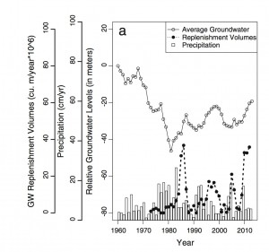
As the graph shows, the overall average groundwater level in the basin appears to have “recovered” to ’round about the level it was at in the 1970s when the recharge efforts began. But the key point in the new Thomas and Famiglietti paper is that aquifers and complicated, and a single overall average is misleading. It’s not like a big lake down there, with water easily moving about hither and yon. If you’re an individual pumper, you’re not pumping from the “Average Groundwater”, you’re pumping from a particular spot.
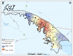
And their spatial work showing where aquifers are rising and falling shows that replenishment is concentrated in a couple of areas, with a large area in between where the aquifer is falling.
This is where governance becomes important. This map shows a region that will succeed or fail depending on the adaptive capacity provided by its water governance structure to move water around, share surplus and shortage, and create the needed equity among the pumpers and water users of a heterogeneous community. The authors write:
Despite a legally complex mix of agreements to secure surface water allocations for groundwater replenishment and irrigation, the spatial patterns of overdraft remain evident.
The paper is:


