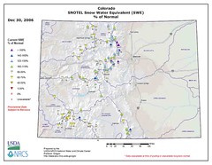
It’ll be another few days before the InterWeb data sources catch up with what the eastern two Four Corners states must call the Big Storm of 2006, but the preliminary data suggests that the water supply implications are less significant than the enormous pile of snow in my Albuquerque backyard might indicate.
Here, in terms of snowfall, December precip, etc., it’s the storm of record.: 16 inches of snow at the official weather station out at the airport, 1.13 inches of snow water equivalent, with reports ranging from 10 inches to 2 feet across the city. For us, that’s epic.
But if you look at the preliminary mountain snowpack numbers, you can see that this storm was not epic everywhere. The nature of the storm, with lots of wrap-around moisture streaming in counter-clockwise around the storm’s center and piling up along the front range in Colorado and mostly east of the continental divide in New Mexico, means that for the big water supply regions, this looks like just a normal winter storm – not at all epic.
The map above is from the NRCS Portland office. Folks there, especially Tom Pagano, have been doing a great job of improving the packaging of the data from their Snotel sites to make it more user-friendly.


Pingback: jfleck at inkstain » Blog Archive » Water Supply Update