On the inevitability of change

I spent an unhappy evening yesterday staring at data, trying to make sense of the inevitability of change. I slept poorly.

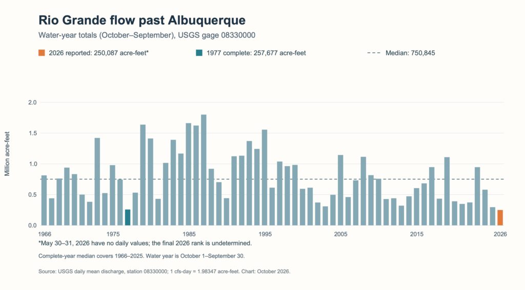
The Rio Grande through Albuquerque is dry, the Colorado River’s reservoirs are rapidly emptying and, unable to come to grips with this reality we have thrown up our hands and tossed the future of the West to the courts.

As a result of Federal Defendants’ issuance of the Final FEIS, ROD, and 2027-2028 Operating Guidelines, Nevada stands to experience a shortfall of 213,556 acre-feet at a 3.6 maf shortage, which constitutes approximately 71% of Nevada’s Colorado River entitlement. This shortfall will cause devastating environmental, socioeconomic, and health and human safety impacts to southern Nevada and its citizens.

Nevada is perhaps the best place to engage this conversation. I turned to Las Vegas back in 2015 when I was writing Water is For Fighting Over because it offered a perfect bait and switch: its Bellagio-fountained image of opulence and water waste contrasted with a reality of the most clear-eyed understanding of the inevitability that there will be less water.

The reality is that every community in the West can use less water than it is using now. We will all have to. But there is an absurdity to a plan that would require Las Vegas to cut 71 percent. That’s existential. Of course Nevada sued.

I’m reminded of what my friend John Entsminger said last December at the Colorado River Water Users Association meeting.

If you distill down what my six partners just said, I believe there’s three common things: Here’s all the great things my state has done. Here’s how hard/impossible it is to do any more. And here are all the reasons why other people should have to do more.

As long as we keep polishing those arguments and repeating them to each other, we are going nowhere.

The irony here is that Las Vegas is a community that has clearly demonstrated what the response to climate change in the West must look like – that has aggressively developed the tools of adaptation and water use reductions.

the Albuquerque story

Map of Albuquerque showing 40 years of greenness trends, with vegetation and therefore, by implication, use declining in NE Heights and stable or rising along the Rio Grande

40 years of declining outdoor vegetation and, by implication, water use reductions (browns and reds) and vegetation increases (greens) in Albuquerque. Map by John Fleck/Google Earth Engine/Claude

For my morning bike ride, I headed out into one of the reddish brown areas in the map above, in Albuquerque’s Northeast Heights. These are places where greenness – trees, lawns, gardens – has declined, as measured by satellite observations that go back to the 1980s. It’s a good proxy for consumptive use of water. While our indoor water is largely recycled, returned to the Rio Grande to support downstream ecosystems and water users, outdoor green is where the real water conservation action is. These oranges and browns represent places where the consumptive use of water has been reduced. My neighborhood. We, as a community, recognized that the amount of green around us was unsustainable. We reduced it.

I could have used Albuquerque as an example 10 years ago in Water is For Fighting Over – in fact, I did a bit in the book. Las Vegas was bigger and offered more storytelling juice, though. Plus Albuquerque’s ambiguities – the green bits on the map – pose a challenge to the narrative. Large areas of the Rio Grande Valley floor, neighborhoods with municipal service but where many homes use domestic wells and irrigation ditch water for outdoor landscaping, are beyond the reach of municipal water conservation programs.

Satellite data map of Albuquerque showing higher water use along the river and the valley floor

Water use in Albuquerque, 2025, via OpenET. Blue is highest, yellows and browns are lowest

Here’s 2025 for the greater Albuquerque area via OpenET. The colors represent a rate of water use, which water nerds could think of as acre-feet per acre – blue is highest, then green-yellow-brown are lower. When you combine the rate – acre-feet per acre – with lower population density (fewer people per acre, much larger lots on the valley floor, many of them served with domestic wells and ditch water) you have a clear disparity in water use. Neighborhoods that have much lower per capita consumptive use of water (less green + smaller lots) are the ones most likely to have been conserving water, reducing their use. Neighborhoods that, because of the combination of large lots, greener landscapes and access to relatively unregulated supplemental water from shallow wells and ditches, have higher per capita use and are more likely to be increasing that use. (Our first cut at the data on pages 31 and following here.)

obligations

As I’ve written previously in this space, that big blue stripe down the middle of the map, the riverside forest we call the bosque, is seeing significant dieback.

We don’t have the science yet, or at least I don’t, to understand the multiple factors that are leading to the dieback. The obvious immediate causal element is that the river that feeds the shallow aquifer that feeds the cottonwood roots has gone dry. Whether the pressure from shallow aquifer pumping from domestic wells adjacent to the river, or deeper pumping from municipal wells, played a role in hastening the water table’s drop away from the cottonwoods’ roots is a question for the groundwater hydrologists.

Folks are working hard and fast on this.

But in the long run we face hard choices as a community. There is less water. There will be less green.

The Colorado River Compact is a dead parrot

A man holds a cage containing a dead parrot and glares at the pet shop owner.

BBC image

A guest post from longtime friend of Inkstain (and friend of the Colorado River) Karl Flessa.

By Karl Flessa

In the classic Monty Python sketch, a customer returns to the pet shop where, just 30 minutes ago, he purchased a parrot.  He complains that the parrot is dead.  The shopkeeper tries to convince the customer the parrot is only resting or is stunned. 

In the ensuing argument, the customer uses no fewer than eighteen euphemisms: “This parrot is definitely deceased…demised…passed on…no more…ceased to be…expired…gone to meet his maker…a stiff…bereft of life…rests in peace…pushing up the daisies…metabolic processes are now history…off the twig…kicked the bucket…shuffled off his mortal coil…run down the curtain…joined the bleedin’ choir invisible.”

Indeed, the parrot was nailed to its perch, already dead when the customer bought it.

The Compact and its subsequent agreements are as dead as that parrot.

  • The Compact is dead because it is founded on a false premise: a river that can produce the prescribed amount of water.
  • The Compact is dead because it is unjust: neither the Tribes nor nature participate in negotiations.
  • The Compact is dead because it doesn’t work.  The Basin States are locked in battle; the Federal government tinkers and dithers.

In the longer version of the sketch, the shopkeeper goes to the back in search of a live replacement, returning to report “…we’re right out of parrots.”

So are we. 

We need a new Compact. 

Proposals are not lacking: proportional allocations, Tribal standing, a whole-basin approach, adjustments based on actual flows, a basin authority, nature’s fair share, interstate trading… .

What’s lacking is the courage to change.    

The Compact is a dead parrot.

Bulldozers at Big Bend

My Rio Grande thinking is almost entirely about the bits in New Mexico, but this, happening now at Big Bend, on the US-Mexico border, is worthy of note:

Bulldozers have begun plowing up ground at the mouth of Big Bend national park’s famed Santa Elena Canyon as part of the Trump administration’s multibillion-dollar “smart wall” expansion on the US-Mexico border, according to new footage taken by activists who have been monitoring the site.

h/t Jack Schmidt

Rapid dieback in Albuquerque’s Rio Grande bosque

An aerial image of a dry riverbed with browning riparian vegetation on either side.

The Albuquerque bosque north of Central. Drone photo by Paul Tashjian, Audubon Southwest.

Albuquerque’s bosque has been suffering a rapid dieback, as shallow aquifers drop away from the roots of the community’s beloved cottonwood gallery forest.

This is uncharted territory for our modern bosque, which grew into its present state after Bureau of Reclamation channeling in the 1950s created the modern river corridor, and flood control and water management practices created a stable source of water that allowed the forest to grow into its present state. From the late 1970s until the last couple of years, the river through Albuquerque essentially never dried, creating conditions under which the bosque could flourish. And it has become a much beloved part of our lives.

In 2026, the bottom has fallen out. We are at 58 days of dry river at the Central Avenue Bridge, where Audubon’s Paul Tashjian took this drone photo. What is usually green is rapidly browning, and it’s not clear how much longer the trees can hold out – what the point of no return might be for, by my quick-and-dirty estimate, ~1,000 acres of normally green bosque forest that is now rapidly browning.

Map showing a line of black pixels representing dieback along the Rio Grande in central Albuquerque

Black: dying bosque. Map by John Fleck, using ESA Sentinel data, Google Earth Engine.

The black pixels in the above image are my best first pass at dying bosque – pixels that are normally green at this time of year that are rapidly browning. (Full map for all of the Bernalillo County Bosque, essentially the last 10 days, here.)

I had reason to hope this would not happen – that the trees with their roots in the shallow aquifer would hang on. There was good evidence for this hope – strips of bosque that have held their green in river reaches farther south as the river routinely dries, and the bosque’s relative stability during last year’s river drying. But the scale of the dieback this year, and its rapidity, shows how wrong I was.

This reflects a deep challenge in our community’s water management systems. We have well developed systems to remove water from the river and the aquifer, to take it out of the river channel and the shallow aquifer – MRGCD irrigation water diversions and the dense network of domestic wells alongside the river irrigating yards that remain green in the midst of this year’s epic drought.

But, as beloved as the bosque is, it grew up as a happy side effect of water management systems developed for other purposes. We have no effective system for leaving water in the river, or for protecting the shallow aquifer on which the bosque depends.

Another Mead-Powell milestone

Line graph showing Lake Mead and Lake Powell storage declining to record or near-record lows, with combined live storage approaching the previous record low set in May 1957 and Lake Mead nearing its pre–May 1937 record low.

For Mead and Powell, fresh record lows. Data: USBR; Graph: Jack Schmidt

By Jack Schmidt and John Fleck

John C. Page, Commissioner of Reclamation, reported to Secretary of the Interior Harold L. Ickes, in announcing the growth of Lake Mead, that the indications are enough water will be caught and stored by Boulder Dam this spring to put the operations of the Boulder Dam plant on a firm or continuous power basis in June. – Kerrville Times, Kerrville Texas, May 13, 1937

Old newspaper headline: "Lake Mead, Largest Man-Mad Body of Water in World, 100 miles long"

Kerrville Times, Kerrville Texas, May 13, 1937

When Lake Mead’s elevation crossed the threshold of 1,040 feet above sea level in the spring of 1937, stretching upstream 100 miles behind Hoover Dam in the deserts of the Arizona Nevada border, it was national news.

So much water!

As Mead drops past that threshold in the opposite direction in the summer of 2026, it’s telling a different story. So little water.

Two milestones in the last few days are worthy of note. The first is Lake Mead itself, which in the last two days dropped past the previous lowest levels in history set in 2022, meaning it is now the lowest it has been since the reservoir was first filled in the 1930s.

Lake Mead was at 7.012 maf yesterday (Aug. 6, 2026) (1040.5 ft).  The previous record low was 7.018 maf (1040.58 ft) that was set on July 28, 2022.  Thus, yesterday’s reservoir contents in Lake Mead are the lowest since at least May 1937.

Meanwhile, Lake Powell is now 85,000 af (1.51 ft) above its lowest historical amount since it was first filled in the 1960s.

But that does not fully capture the extent of the crisis. Total reservoir contents of all 46 reservoirs in the Reclamation data base (extending from Fontenelle and Grand Lakes to Lake Havasu) was at 21.27 maf on July 1, the lowest since at least May 29, 1965 (probably earlier, since the Reclamation data base doesn’t report many reservoir contents at that early date).

“Super” El Niño meh in the Rio Grande and Colorado River headwaters?

Map showing December-January-February forecast for 2026-27 - neutral or dry in Rio Grande and Colorado River headwaters

ECMWF Four Corners December-January-February forecast. Map ECMWF->Fleck->Codex

The latest European Centre for Medium-Range Weather Forecasts got some ink/bits for their strong forecast for a wet winter in California (h/t Daniel Swain), but what do they say for us?

Sorry for the blocky look, but when you drill down, the map gets pretty coarse – these are big pixels. But the headline is that the ECMWF outlook is wet for Arizona, but not much El Niño-bullish for the headwaters of the Rio Grande and the Colorado.

Green returning to the Sahel

Near-extinct oryx are returning. Farms are prospering as irrigation water reaches fields for the first time in decades. Farmers are even nurturing new trees on their land. Once a byword for drought and famine, the African Sahel region on the southern flank of the Sahara Desert now has more water than it has for decades. Wells are filling as water tables have risen by 13 feet or more in places. Lake Chad, which was one of Africa’s largest expanses of water before shriveling during the droughts, is recovering. 

Fred Pearce in YaleEnvironment360

Boats Against the Current

So we beat on, boats against the current, borne back ceaselessly into the past.

– F. Scott Fitzgerald, The Great Gatsby

George Cukor’s solid 1938 screwball comedy Holiday follows a classically satisfying three-act structure.

In Act I, Cukor reveals the problem facing our protagonist, Johnny Case (Cary Grant). Case is going to visit the home of his newly met newfound true love, only to find that she’s the daughter of staggering Park Avenue wealth. Hilarity ensues as Case meets Julia Seton’s (Doris Nolan) family (notably Katherine Hepburn as sister Linda) and the scale of their wealth is revealed room by Park Avenue mansion room. But as the first Act closes, we are introduced to the problem, as Julia breaks the news to her stuffy, wealthy father that she is engaged to be married. In classic screwball comedy fashion, this does not go well.

In Act II, the tension builds, as the Setons’ wealth and daddy’s expectations clash with Case’s values and desires for his life. The peril grows (it’s a screwball comedy, so the peril is of a certain sort) as we see how unhappy Julia’s sister Linda and brother Ned are, trapped by the wealth. (It’s fun in a Monopoly moneybags guy kinda way to see how Depression-era filmmakers treat gilded age wealth.) You see the tension building as the veil slowly lifts from Case’s eyes (Cary Grant is so good here.).

In Act III, the crisis comes to a head at the New Years Eve party/engagement announcement at the Seton mansion. Cue gowns, and tails, and lots of up and down the stairs. (“The third act must build, build, build in tempo and action until the last event,” to quote Billy Wilder.) Cukor’s good but not great here, because of the way he lets the energy flag a bit with a time gap before the crisis blows up. But then the resolution – Case walks out on Julia, but Linda follows, she’s really the girl for Case, which of course we saw coming because Hepburn got the film’s top billing alongside Grant. Satisfying ending, happily ever after, QED.

It’s not exactly classic – it was nominated for the Best Art Direction Oscar, who remembers that – but it’s a solid piece of work from the Columbia factory line. Cukor stuck with a reliable formula, the script is sharp and funny, and you can’t go wrong with Hepburn and Grant (and Edward Everett Horton, we made a note to run down as many of Horton’s movies as we can find for free or cheap).

on structure

I’m at that point in the new book project where I’m wrestling with structure. My co-author Bob Berrens and I have assembled a ton of material, driven by our shared love of deep and slightly chaotic research. (Slightly? Eye roll.)

My deep dive into classic Hollywood is mostly just shared fun (Lissa and I love watching old movies) but I can’t watch a good storyteller assemble a piece without thinking about how they did it. Bob and I have a growing pile of building blocks. How to assemble them?

There’s a scene in Cameron Crowe’s book of interviews with Billy Wilder, Conversations with Wilder where Wilder asks Crowe if he has an ending for the book. It’s part of the book’s meta-narrative, as Crowe or Wilder or sometimes both turn to discussing the making of a book in which they are the two lead characters. (It’s a great book.) Crowe hedges, and Wilder suggests the obvious solution. Wilder should die!

Of course this is real life, and Wilder doesn’t die. The book has a nice kicker, a hilarious Wilder quote, but there is no closure.

And that is the challenge of writing about rivers and people. There is no ending, no closure.

One of the core themes of the new book is the question of obligation – obligations to those upstream and downstream, of the past toward the future, of the obligations to the river itself. Our interest is people and the rivers with which they share the landscape, the manifold ways that relationship plays out. At the heart of that is the question of obligation. When people disconnect a river from its flood plain, they take on a forever obligation of maintaining the river in its new form. Or more generally, the forever obligation associated with the linkage of people and their water.

The river changes, people change, values change, institutions change. This, I have read, is the classic innovation of Shakespeare – the ideas that characters evolve over the course of the play.

This version of narrative structure works great in my stories about rivers. Until it doesn’t.

People embrace a river, but by the end of Act I it’s clear that the river is pushing back, revealing its true self. That’s the pre-story in Ribbons of Green as Puebloans, Spanish colonizers and early Americans settle in the Middle Rio Grande Valley.

Act II is filled with the struggles to respond to that riverine true self – the floods, the swamps, the droughts. The struggles build, the communities evolve in response. There are half-solutions, and change, and more half-solutions, and more change.

Act III is where the classic Hollywood three-act structure falls apart for me, because I can’t build toward a catastrophic moment that in a flash changes everything, what Wilder calls “the last event,” followed by a tidy tying up of loose ends.

This is where Wilder shines, because like F. Scott Fitzgerald’s famed kicker in The Great Gatsby, the great problems of their narratives, and mine, are never done.