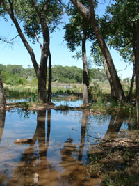
Lissa and I took a wander south this afternoon through the Rio Grande Valley south of Albuquerque.
Our bosque - the riverside woods - is usually dry, but the river has crested its banks and spread into the cottonwoods. I've never seen this before in the 15 years I've lived here, and it's been fascinating. (Tania Soussan has a good story about all this in today's Journal (sub. req.)
(click through for more)
For those of you who live in the Albuquerque area, I recommend the drive south to Los Lunas to see it. The pictures above were taken at the park on the south side of the river where the main Los Lunas bridge crosses.
In Albuquerque itself, the river is largely staying within its banks. That is because the river channel is deeper in the northern reaches of the middle Rio Grande Valley. It's a result of the hydrologic changes in the system created by Cochiti Dam. As the clear water leaves the dam, it tends to downcut the upper reaches of this stretch of the river, depositing its silt further south. So up north it's downcutting, and farther south it's aggrading, deposit its silt and shallowing the channel. So as you get farther south, there's more tendency to spill over the old banks and into the bosque.
The risk of flooding here is pretty much zero right now, because they can control the output from Cochiti. They've been releasing 6,000 to 6,500 cubic feet per second lately, and you can see on the downstream river gauges that the flow through Albuquerque and points south pretty much mirrors the amount they release from Cochiti.
Posted by John Fleck at June 05, 2005 04:26 PM