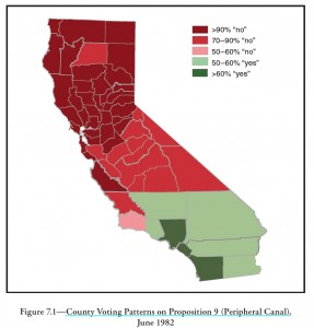
Here’s a cool map for folks thinking about California’s current discussions about building some sort of Peripheral Thingie to carry water around (through? beneath?) the Sacramento-San Joaquin Delta:
That’s the vote thirty years ago on a ballot initiative asking voters whether the state might build a Peripheral Canal to do the same thing. The red bits show level of pissed-off-ness about the idea. The green bits show where people liked it.
In governance terms, California’s always been an unwieldy beast – divided north-south, divided urban-rural, divided in some sense east-west (coastal-inland?).
Map courtesy PPIC. (pdf) Nice interactive web version of the map here.


AFAIK this voting pattern is unique in the history of CA ballot measures. I don’t think views have changed much since then. There’s a bit more of a population tilt toward the south but, even assuming no shift in sentiment there, nothing like what would be needed to overcome the intensity in the north.
What I really don’t get about the current process is how the people running it ever thought they could get away with designing a Thingie big enough to practically dewater the Delta (well, strictly speaking turn it into a brackish sump).